
Journal of Tropical Oceanography >
Remote sensing estimation of green macroalgae Ulva pertusa based on unmanned aerial vehicle and satellite image
Copy editor: LIN Qiang
Received date: 2021-07-09
Revised date: 2021-09-02
Online published: 2021-09-19
Supported by
National Natural Science Foundation of China(42076188)
National Natural Science Foundation of China(41676171)
The Strategic Priority Research Program of the Chinese Academy of Sciences(XDA1906000)
The Strategic Priority Research Program of the Chinese Academy of Sciences(XDA19060203)
The Strategic Priority Research Program of the Chinese Academy of Sciences(XDA19060501)
The Instrument Developing Project of the Chinese Academy of Sciences(YJKYYQ20170048)
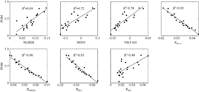
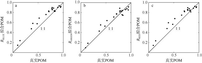
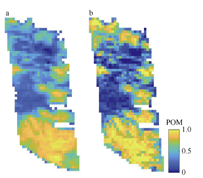
Satellite images are valuable data sources for monitoring floating green macroalgae on the sea surface. However, there are large errors in green macroalgae coverage derived on mixed pixels. It is thus important to solve the problem of sub-pixel coverage of green macroalgae, for precise monitoring of benthic green macroalgae in coastal area. In this paper, retrieval models were established to link sub-pixel coverage of green macroalgae with vegetation indexes and reflectance of characteristic bands by analyzing spectral characteristics of green macroalgae from the Landsat images, based on the results of green macroalgae coverage derived from unmanned aerial vehicle (UAV). The results show excellent linear relationships between the reflectance of blue, green, and red bands and the sub-pixel coverage of green macroalgae, and the reflectance decreases monotonically with increasing sub-pixel coverage. These three models were verified, and the results show that the model based on the reflectance of green band was more accuracy than the other indexes or index combination, with the highest coefficient of determination (R2), root mean square error (RMSE), and mean relative error (MRE) values of 0.92, 0.07, and 10.85%, respectively. Hence, we provide a model that can estimate the sub-pixel coverage of green macroalgae, and realize the precise monitoring of the coverage of green macroalgae extracted from Landsat images.
MENG Miaomiao , ZHENG Xiangyang , XING Qianguo , LIU Hailong . Remote sensing estimation of green macroalgae Ulva pertusa based on unmanned aerial vehicle and satellite image[J]. Journal of Tropical Oceanography, 2022 , 41(3) : 46 -53 . DOI: 10.11978/2021088
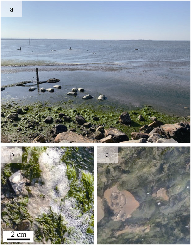
图1 研究区现场照片(a)及沉水状态(b)和低潮干出状态(c)下的孔石莼Fig. 1 Field photo of the study area (a) and Ulva pertusa under submerged condition (b), as well as under emerged condition during low tide (c) |
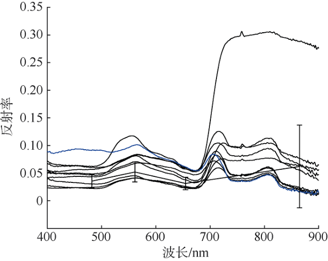
图2 孔石莼与海水的光谱反射率粗体黑线表示绿藻光谱曲线对应landsat-8第二到第五波段重采样的平均值, “┬”表示标准差 Fig. 2 Reflectance spectra of the Ulva pertusa and sea water, with the bold black line showing the mean reflectance of Ulva pertusa corresponding to the second to the fifth band of Landsat-8. “┬” is for standard deviation (S.D.) |
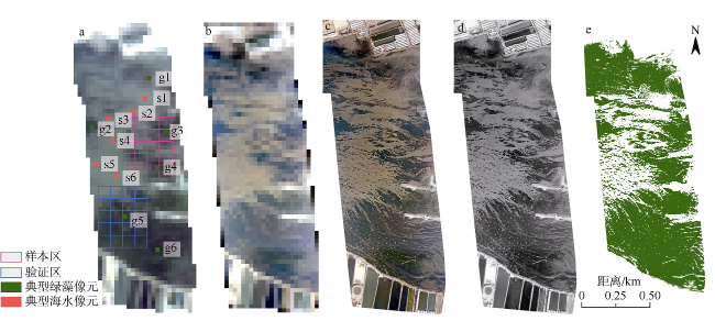
图3 研究区遥感影像及绿藻提取结果a. Landsat-8图像; b. 无人机影像重采样; c. 无人机影像; d. 红波段灰度图; e. 无人机影像绿藻提取结果 Fig. 3 Remote sensing images of the study area and the results of green macroalgae extraction. (a) Landsat-8 image; (b) Unmanned aerial vehicle (UAV) image resampling; (c) UAV image; (d) gray image of red band; (e) green macroalgae information extracted from UAV image |
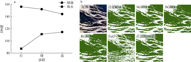
表1 不同绿藻提取方法精度对比Tab. 1 Comparation on accuracy of green macroalgae extraction with different methods |
| 动态阈值法 | 提取一致性 | Kappa | F1 score |
|---|---|---|---|
| NGRDI | 89% | 0.72 | 0.83 |
| NGBDI | 83% | 0.68 | 0.79 |
| RGRI | 79% | 0.62 | 0.74 |
| ExG | 77% | 0.38 | 0.65 |
| 红波段DN值 | 94% | 0.88 | 0.92 |
图7 验证区蓝(a)、绿(b)、红(c)波段反演模型散点图Fig. 7 Scatter plots for retrieval models of blue (a), green (b) and red (c) bands of the verification area |
表2 蓝、绿、红波段反演模型结果比较Tab. 2 Comparison of retrieval results for blue, green and red bands' retrieval models |
| 输入值 | 公式 | R2 | 均方根误差(RMSE) | 平均相对误差(MRE) |
|---|---|---|---|---|
| RRED RGREEN RBLUE | y=-20.08x+1.31 y=-22.73x+1.6 y=-33.86x+1.53 | 0.87 0.92 0.86 | 0.09 0.07 0.09 | 17.64% 10.85% 18.11% |
| [1] |
安德玉, 邢前国, 魏振宁, 等, 2018. 黄海典型漂浮大型藻类光谱特征分析[J]. 海洋与湖沼, 49(5): 1054-1060.
|
| [2] |
丁一, 黄娟, 崔廷伟, 等, 2015. 基于NDVI与丰度关系的MODIS影像浒苔混合像元分解方法[J]. 海洋学报, 37(7): 123-131.
|
| [3] |
樊彦国, 白羽, 陈潘潘, 等, 2015. 青岛近海浒苔光谱特征研究[J]. 海洋科学, 39(4): 87-91.
|
| [4] |
蒋兴伟, 刘建强, 邹斌, 等, 2009. 浒苔灾害卫星遥感应急监视监测系统及其应用[J]. 海洋学报, 31(1): 52-64.
|
| [5] |
刘岩, 刘涛, 于丹, 等, 2010. 常见石莼科绿藻的生物学特征及分子系统学分析[J]. 中国海洋大学学报, 40(12): 71-80.
|
| [6] |
邢前国, 郑向阳, 施平, 等, 2011. 基于多源、多时相遥感影像的黄、东海绿潮影响区检测[J]. 光谱学与光谱分析, 31(6): 1644-1647.
|
| [7] |
|
| [8] |
|
| [9] |
|
| [10] |
|
| [11] |
|
| [12] |
|
| [13] |
|
| [14] |
|
| [15] |
|
| [16] |
|
| [17] |
|
| [18] |
|
| [19] |
|
| [20] |
|
| [21] |
|
| [22] |
|
| [23] |
|
| [24] |
|
| [25] |
|
| [26] |
|
| [27] |
|
| [28] |
|
| [29] |
|
/
| 〈 |
|
〉 |

