
Journal of Tropical Oceanography >
Structure study of the northeastern Zhongsha Trough Basin in the South China Sea based on prestack depth migration seismic imaging
Received date: 2018-06-22
Request revised date: 2018-08-20
Online published: 2019-04-15
Supported by
China Geological Survey Project (DD20160138, DD20189823)
National Natural Science Foundation of China (41604110)
Copyright
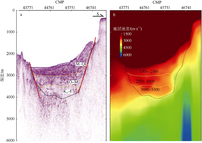
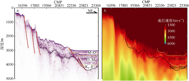
Based on analysis of the seismic images from prestack depth migration, combining previous results inverted from geophysical data, e.g., gravity and magnetic inversions and so on, we investigate the structure of the northeastern Zhongsha Trough Basin in the South China Sea. The results indicate that the Cenozoic strata are developed with a thickness of 1500~2500 m, and the stratum velocity is 1500~3500 m·s-1. There is no Mesozoic sedimentary layer. The base of the basin could be seamount, Precambrian bedrock, or magma uplift. The abundance of Cenozoic terrigenous marine source rocks, the thick layer of the Cenozoic strata, and well-developed basin depressions and faults all suggest that the northeastern Zhongsha Trough Basin has a certain potential for oil and gas exploration.
ZHAO Bin , GAO Hongfang , ZHANG Heng , LI Liqing . Structure study of the northeastern Zhongsha Trough Basin in the South China Sea based on prestack depth migration seismic imaging[J]. Journal of Tropical Oceanography, 2019 , 38(2) : 95 -102 . DOI: 10.11978/2018066
Fig. 1 Geographical location map of the study area. The boundary of the Zhongsha Trough Basin modified after Liang et al (2013). Lines DD′ and EE′ are gravity and magnetic inversion profiles, according to Hao et al (2011)图1 研究区地理位置图 |
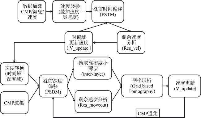
Fig. 2 Flow chart of prestack depth migration processing for multi-channel seismic data used in this paper图2 本文采用的多道地震数据叠前深度偏移处理流程, 据赵斌等(2018) |
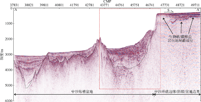
Fig. 3 Prestack depth migration profile of line AA′图3 测线AA′叠前深度偏移剖面 |
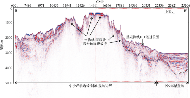
Fig. 4 Prestack depth migration profile of line BB′图4 测线BB′叠前深度偏移剖面 |
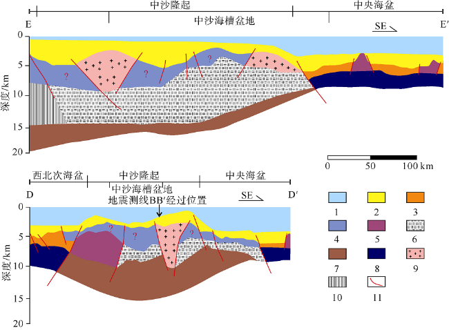
Fig. 5 Geologic interpretation map of the gravity and magnetic inversion section of the Zhongsha Trough Basin. Modified from Hao et al (2011). The location of the section is shown in |
Fig. 6 The northeastern Zhongsha Trough Basin structure interpreted from depth migration profile. Location of line AA′ is indicated in |
Fig. 7 The northeastern Zhongsha Trough Basin structure interpreted from depth migration profile. Location of line BB′ is indicated in |
The authors have declared that no competing interests exist.
| [1] |
|
| [2] |
|
| [3] |
|
| [4] |
|
| [5] |
|
| [6] |
|
| [7] |
|
| [8] |
|
| [9] |
|
| [10] |
|
| [11] |
|
| [12] |
|
| [13] |
|
| [14] |
|
| [15] |
|
| [16] |
|
| [17] |
|
| [18] |
|
| [19] |
|
| [20] |
|
| [21] |
|
| [22] |
|
| [23] |
|
| [24] |
|
| [25] |
|
| [26] |
|
| [27] |
|
| [28] |
|
| [29] |
|
| [30] |
|
| [31] |
|
/
| 〈 |
|
〉 |

