
Journal of Tropical Oceanography ›› 2019, Vol. 38 ›› Issue (2): 95-102.doi: 10.11978/2018066CSTR: 32234.14.2018066
• Marine Geophysics • Previous Articles
Structure study of the northeastern Zhongsha Trough Basin in the South China Sea based on prestack depth migration seismic imaging
Bin ZHAO1,2( ), Hongfang GAO1,3, Heng ZHANG1,2, Liqing LI1,2
- 1. Ministry of Natural Resources Key Laboratory of Marine Mineral Resources, Guangzhou 510075, China
2. Data Processing Institute of Guangzhou Marine Geological Survey, Guangzhou 510760, China
3. Institute of Geology Survey, Guangzhou Marine Geological Survey, Guangzhou 510760, China
-
Received:2018-06-22Revised:2018-08-20Online:2019-03-20Published:2019-04-15 -
Supported by:China Geological Survey Project (DD20160138, DD20189823);National Natural Science Foundation of China (41604110)
CLC Number:
- P738.4
Cite this article
Bin ZHAO, Hongfang GAO, Heng ZHANG, Liqing LI. Structure study of the northeastern Zhongsha Trough Basin in the South China Sea based on prestack depth migration seismic imaging[J].Journal of Tropical Oceanography, 2019, 38(2): 95-102.
share this article
Add to citation manager EndNote|Reference Manager|ProCite|BibTeX|RefWorks
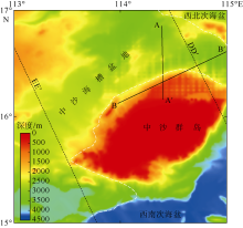
Fig. 1
Geographical location map of the study area. The boundary of the Zhongsha Trough Basin modified after Liang et al (2013). Lines DD′ and EE′ are gravity and magnetic inversion profiles, according to Hao et al (2011)"

Fig. 1

Fig. 2
Flow chart of prestack depth migration processing for multi-channel seismic data used in this paper"
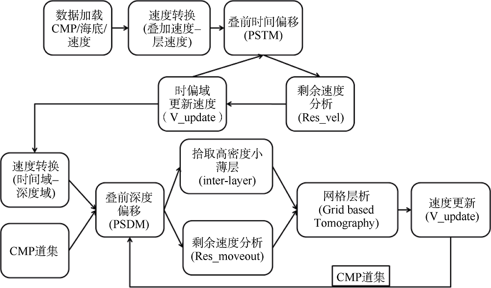
Fig. 2
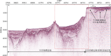
Fig. 3
Prestack depth migration profile of line AA′"
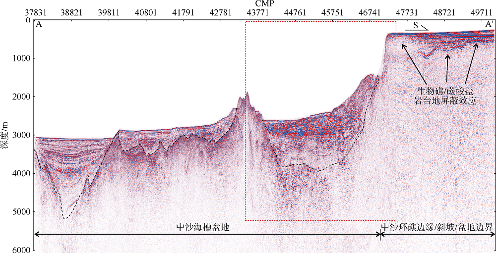
Fig. 3
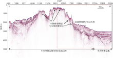
Fig. 4
Prestack depth migration profile of line BB′"
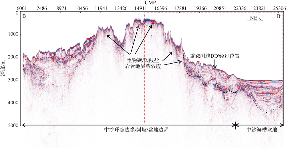
Fig. 4
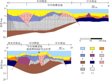
Fig. 5
Geologic interpretation map of the gravity and magnetic inversion section of the Zhongsha Trough Basin. Modified from Hao et al (2011). The location of the section is shown in Fig. 1. 1: Sea water; 2: Cenozoic/Ocean layer 1; 3: Ocean layer 2; 4: Mesozoic; 5: Seamount; 6: Precambrian basement and magma uplift; 7: Lower crust; 8: Oceanic layer 3; 9: Magmatic rock; 10: Metamorphic basement in depression; and 11: Fault"

Fig. 5
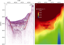
Fig. 6
The northeastern Zhongsha Trough Basin structure interpreted from depth migration profile. Location of line AA′ is indicated in Fig. 3. (a) interpretation of the seismic profile; (b) interpretation of the layer velocity profile. K2: Late Cretaceous; E: Eocene; O: Oligocene; M: Miocene; Q: Quaternary"
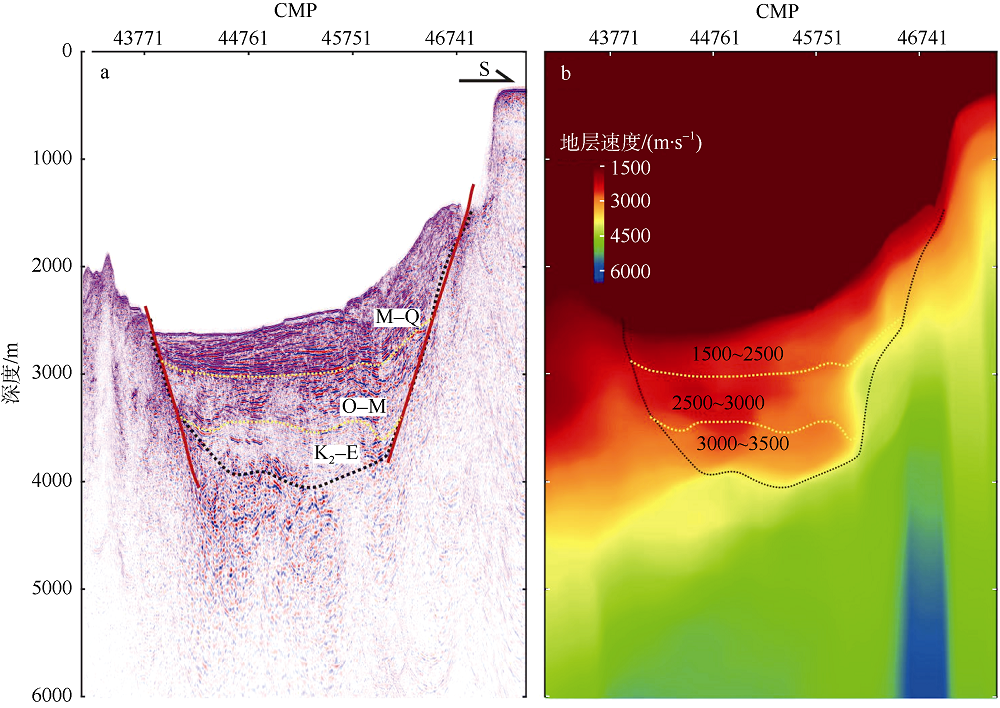
Fig. 6
Fig. 7
The northeastern Zhongsha Trough Basin structure interpreted from depth migration profile. Location of line BB′ is indicated in Fig. 4. (a) Interpretation of the seismic profile; (b) interpretation of the layer velocity profile. K2: Late Cretaceous; E: Eocene; O: Oligocene; M: Miocene; Q: Quaternary"

Fig. 7
| [1] |
高红芳, 陈玲, 2006. 南海西部中建南盆地构造格架及形成机制分析[J]. 石油与天然气地质, 27(4): 512-516.
doi: 10.11743/ogg20060411 |
|
GAO HONGFANG, CHEN LING, 2006. An analysis of structural framework and formation mechanism of Zhongjiannan basin in the west of South China Sea[J]. Oil & Gas Geology, 27(4): 512-516 (in Chinese with English abstract).
doi: 10.11743/ogg20060411 |
|
| [2] |
高红芳, 王衍棠, 郭丽华, 2007. 南海西部中建南盆地油气地质条件和勘探前景分析[J]. 中国地质, 34(4): 592-598.
doi: 10.3969/j.issn.1000-3657.2007.04.006 |
|
GAO HONGFANG, WANG YANTANG, GUO LIHUA, 2007. Petroleum geological conditions and prospects in the Zhongjiannan basin in the western South China Sea[J]. Geology in China, 34(4): 592-598 (in Chinese with English abstract).
doi: 10.3969/j.issn.1000-3657.2007.04.006 |
|
| [3] |
郝天珧, 徐亚, 孙福利, 等, 2011. 南海共轭大陆边缘构造属性的综合地球物理研究[J]. 地球物理学报, 54(12): 3098-3116.
doi: 10.3969/j.issn.0001-5733.2011.12.011 |
|
HAO TIANYAO, XU YA, SUN FULI, et al, 2011. Integrated geophysical research on the tectonic attribute of conjugate continental margin of South China Sea[J]. Chinese Journal of Geophysics, 54(12): 3098-3116 (in Chinese with English abstract).
doi: 10.3969/j.issn.0001-5733.2011.12.011 |
|
| [4] |
胡卫剑, 江为为, 郝天珧, 等, 2011. 南海前新生代残留盆地分布综合地球物理研究[J]. 地球物理学报, 54(12): 3315-3324.
doi: 10.3969/j.issn.0001-5733.2011.12.029 |
|
HU WEIJIAN, JIANG WEIWEI, HAO TIANYAO, et al, 2011. Integrated geophysical research on the distribution of Pre-Cenozoic residual basins in the South China Sea[J]. Chinese Journal of Geophysics, 54(12): 3315-3324 (in Chinese with English abstract).
doi: 10.3969/j.issn.0001-5733.2011.12.029 |
|
| [5] | 黄金森, 1987. 中沙环礁特征[J]. 海洋地质与第四纪地质, 7(2): 21-24. |
| HUANG JINSEN, 1987. Features of the Zhongsha atoll in the South China Sea[J]. Marine Geology & Quaternary Geology, 7(2): 21-24 (in Chinese with English abstract). | |
| [6] | 李绪深, 张迎朝, 杨希冰, 等, 2017. 莺歌海—琼东南盆地天然气勘探新认识与新进展[J]. 中国海上油气, 29(6): 1-11. |
| LI XUSHEN, ZHANG YINGZHAO, YANG XIBING, et al, 2017. New understandings and achievements of natural gas exploration in Yinggehai-Qiongdongnan Basin, South China Sea[J]. China Offshore Oil and Gas, 29(6): 1-11 (in Chinese with English abstract). | |
| [7] | 梁建设, 张功成, 王璞珺, 等, 2013. 南海陆缘盆地构造演化与烃源岩特征[J]. 吉林大学学报(地球科学版), 43(5): 1309-1319. |
| LIANG JIANSHE, ZHANG GONGCHENG, WANG PUJUN, et al, 2013. Tectonic evolution of epicontinental basins in South China Sea and their feature of source rocks[J]. Journal of Jilin University (Earth Science Edition), 43(5): 1309-1319 (in Chinese with English abstract). | |
| [8] | 刘宝明, 刘海龄, 2011. 南海及邻区中生界——新的油气勘探领域[J]. 海洋地质与第四纪地质, 31(2): 105-109. |
| LIU BAOMING, LIU HAILING, 2011. The Mesozoic in the South China Sea and adjacent areas: new targets for hydrocarbon exploration[J]. Marine Geology & Quaternary Geology, 31(2): 105-109 (in Chinese with English abstract). | |
| [9] |
刘昭蜀, 赵岩, 李希宗, 等, 1995. 珠江口盆地的扩张旋回及其与含油气性的关系[J]. 热带海洋, 14(3): 8-15.
doi: 10.1088/0256-307X/12/7/010 |
|
LIU ZHAOSHU, ZHAO YAN, LI XIZONG, et al, 1995. Spreading cycle and relation to the hydrocarbon potential of Zhujiang River Mouth Basin[J]. Tropic Oceanology, 14(3): 8-15 (in Chinese with English abstract).
doi: 10.1088/0256-307X/12/7/010 |
|
| [10] |
鲁宝亮, 王璞珺, 吴景富, 等, 2014. 南海陆缘盆地中生界分布特征及其油气地质意义[J]. 石油勘探与开发, 41(4): 497-503.
doi: 10.11698/PED.2014.04.17 |
|
LU BAOLIANG, WANG PUJUN, WU JINGFU, et al, 2014. Distribution of the Mesozoic in the continental margin basins of the South China Sea and its petroliferous significance[J]. Petroleum Exploration and Development, 41(4): 497-503 (in Chinese with English abstract).
doi: 10.11698/PED.2014.04.17 |
|
| [11] |
鲁宝亮, 王璞珺, 张功成, 等, 2011. 南海北部陆缘盆地基底结构及其油气勘探意义[J]. 石油学报, 32(4): 580-587.
doi: 10.1007/s12182-011-0123-3 |
|
LU BAOLIANG, WANG PUJUN, ZHANG GONGCHENG, et al, 2011. Basement structures of an epicontinental basin in the northern South China Sea and their significance in petroleum prospect[J]. Acta Petrolei Sinica, 32(4): 580-587 (in Chinese with English abstract).
doi: 10.1007/s12182-011-0123-3 |
|
| [12] | 栾锡武, 张亮, 2009. 南海构造演化模式: 综合作用下的被动扩张[J]. 海洋地质与第四纪地质, 29(6): 59-74. |
| LUAN XIWU, ZHANG LIANG, 2009. Tectonic evolution modes of South China Sea: passive spreading under complex actions[J]. Marine Geology & Quaternary Geology, 29(6): 59-74 (in Chinese with English abstract). | |
| [13] |
潘兴祥, 秦宁, 曲志鹏, 等, 2013. 叠前深度偏移层析速度建模及应用[J]. 地球物理学进展, 28(6): 3080-3085.
doi: 10.6038/pg20130632 |
|
PAN XINGXIANG, QIN NING, QU ZHIPENG, et al, 2013. Tomography velocity modeling and application of prestack depth migration[J]. Progress in Geophysics, 28(6): 3080-3085 (in Chinese with English abstract).
doi: 10.6038/pg20130632 |
|
| [14] | 施和生, 何敏, 张丽丽, 等, 2014. 珠江口盆地(东部)油气地质特征、成藏规律及下一步勘探策略[J]. 中国海上油气, 26(3): 11-22. |
| SHI HESHENG, HE MIN, ZHANG LILI, et al, 2014. Hydrocarbon geology, accumulation pattern and the next exploration strategy in the eastern Pearl River Mouth basin[J]. China Offshore Oil and Gas, 26(3): 11-22 (in Chinese with English abstract). | |
| [15] | 孙万元, 刘仕友, 李洋森, 等, 2017. 深度域高分辨率地震资料反演应用研究——以琼东南盆地深度域反演为例[J]. 地球物理学进展, 32(4): 1643-1649. |
| SUN WANYUAN, LIU SHIYOU, LI YANGSEN, et al, 2017. Research of the depth domain inversion of the seismic data: a case of depth domain inversion in Qiongdongnan basin[J]. Progress in Geophysics, 32(4): 1643-1649 (in Chinese with English abstract). | |
| [16] |
王维红, 林春华, 陈志德, 等, 2011. 古龙断陷深层火山岩地震资料成像方法及应用研究[J]. 地球物理学报, 54(2): 310-319.
doi: 10.3969/j.issn.0001-5733.2011.02.006 |
|
WANG WEIHONG, LIN CHUNHUA, CHEN ZHIDE, et al, 2011. Seismic data imaging techniques and their application for igneous rock formation in Gulong fault depression[J]. Chinese Journal of Geophysics, 54(2): 310-319 (in Chinese with English abstract).
doi: 10.3969/j.issn.0001-5733.2011.02.006 |
|
| [17] |
魏喜, 邓晋福, 谢文彦, 等, 2005. 南海盆地演化对生物礁的控制及礁油气藏勘探潜力分析[J]. 地学前缘, 12(3): 245-252.
doi: 10.3321/j.issn:1005-2321.2005.03.026 |
|
WEI XI, DENG JINFU, XIE WENYAN, et al, 2005. Constraints on biogenetic reef formation during evolution of the South China Sea and exploration potential analysis[J]. Earth Science Frontiers, 12(3): 245-252 (in Chinese with English abstract).
doi: 10.3321/j.issn:1005-2321.2005.03.026 |
|
| [18] | 吴能友, 曾维军, 杜德莉, 等, 1999. 南海区域岩石圈的壳-幔耦合关系幔耦合关系纵向演化[J]. 海洋地质与第四纪地质, 19(1): 31-38. |
| WU NENGYOU, ZENG WEIJUN, DU DELI, et al, 1999. Crust-mantle coupling model and vertical evolution of lithosphere of South China Sea region[J]. Marine Geology & Quaternary Geology, 19(1): 31-38 (in Chinese with English abstract). | |
| [19] | 吴能友, 曾维军, 宋海斌, 等, 2003. 南海区域构造沉降特征[J]. 海洋地质与第四纪地质, 23(1): 55-56. |
| WU NENGYOU, ZENG WEIJUN, SONG HAIBIN, et al, 2003. Tectonic subsidence of the South China Sea[J]. Marine Geology & Quaternary Geology, 23(1): 55-56 (in Chinese with English abstract). | |
| [20] | 许自强, 但志伟, 王新领, 等, 2013. 深水区各向异性叠前深度偏移成像[J]. 石油地球物理勘探, 48(S1): 17-22. |
| XU ZIQIANG, DAN ZHIWEI, WANG XINLING, et al, 2013. Anisotropic prestack depth migration imaging in Deepwater area[J]. Oil Geophysical Prospecting, 48(S1): 17-22 (in Chinese with English abstract). | |
| [21] | 杨胜雄, 邱燕, 朱本铎, 2015. 南海地质地球物理图系[M]. 天津: 中国航海图书出版社. |
| YANG SHENGXIONG, QIU YAN, ZHU BENDUO, 2015. Atlas of Geology and Geophysicsof the South China Sea[M]. Tianjin: China Navigation Publications Press (in Chinese). | |
| [22] |
杨希冰, 2016. 南海北部北部湾盆地油气藏形成条件[J]. 中国石油勘探, 21(4): 85-92.
doi: 10.3969/j.issn.1672-7703.2016.04.009 |
|
YANG XIBING, 2016. Hydrocarbon accumulation conditions in Beibu-gulf Basin northern South China Sea[J]. China Petroleum Exploration, 21(4): 85-92 (in Chinese with English abstract).
doi: 10.3969/j.issn.1672-7703.2016.04.009 |
|
| [23] | 姚伯初, 1998. 南海新生代的构造演化与沉积盆地[J]. 南海地质研究, 1-17. |
| YAO BOCHU, 1998. The tectonic evolution and sedimentary basins of south China in Cenozoic[J]. Geological Research of South China Sea, 1-17 (in Chinese with English abstract). | |
| [24] | 张功成, 谢晓军, 王万银, 等, 2013. 中国南海含油气盆地构造类型及勘探潜力[J]. 石油学报, 34(4): 611-627. |
| ZHANG GONGCHENG, XIE XIAOJUN, WANG WANYIN, et al, 2013. Tectonic types of petroliferous basins and its exploration potential in the South China Sea[J]. Acta Petrolei Sinica, 34(4): 611-627 (in Chinese with English abstract). | |
| [25] | 张功成, 朱伟林, 米立军, 等, 2010. “源热共控论”: 来自南海海域油气田“外油内气”环带有序分布的新认识[J]. 沉积学报, 28(5): 987-1005. |
| ZHANG GONGCHENG, ZHU WEILIN, MI LIJUN, et al, 2010. The theory of hydrocarbon genernation controlled by source rock and heat from circle distribution of outside-oil fields and inside-gas fields in South China Sea[J]. Acta Sedimentologica Sinica, 28(5): 987-1005 (in Chinese with English abstract). | |
| [26] | 张强, 吕福亮, 贺晓苏, 等, 2018. 南海近5年油气勘探进展与启示[J]. 中国石油勘探, 23(1): 54-61. |
| ZHANG QIANG, LV FULIANG, HE XIAOSU, et al, 2018. Progress and enlightenment of oil and gas exploration in the South China Sea in recent five years[J]. China Petroleum Exploration, 23(1): 54-61 (in Chinese with English abstract). | |
| [27] | 赵斌, 张衡, 高红芳, 等, 2018. 叠前深度偏移技术在珠江口盆地的应用及其地质意义[J]. 海洋地质前沿, 34(7): 65-70. |
| ZHAO BIN, ZHANG HENG, GAO HONGFANG, et al, 2018. Seismic data processing based on prestack depth migration and its application to the Pearl River Mouth Basin[J]. Marine Geology Frontiers, 34(7): 65-70 (in Chinese with English abstract). | |
| [28] |
钟广见, 吴世敏, 冯常茂, 2011. 南海北部中生代沉积模式[J]. 热带海洋学报, 30(1): 43-48.
doi: 10.3969/j.issn.1009-5470.2011.01.006 |
|
ZHONG GUANGJIAN, WU SHIMIN, FENG CHANGMAO, 2011. Sedimentary model of Mesozoic in the northern South China Sea[J]. Journal of Tropical Oceanography, 30(1): 43-48 (in Chinese with English abstract).
doi: 10.3969/j.issn.1009-5470.2011.01.006 |
|
| [29] |
BAYSAL E, KOSLOFF D D, SHERWOOD J W C, 1983. Reverse time migration[J]. Geophysics, 48(11): 1514-1524.
doi: 10.1190/1.1441434 |
| [30] | DAI HENGCHANG, LI XIANGYANG, CONWAY P, 2004. 3D pre-stack Kirchhoff time migration of PS-waves and migration velocity model building[C]//Proceedings of the 2004 SEG annual meeting. Denver: SEG, 23: 1115-1118. |
| [31] |
WU NENGYOU, ZENG WEIJUN, LI ZHENWU, et al, 1999. Characteristics of upper mantle activity in the South China sea region and the Indochina mantle plume[J]. Acta Geologica Sinica, 73(4): 464-476.
doi: 10.1111/acgs.1999.73.issue-4 |
| [1] | LI Bo’an, HU Shanzheng, YAN Pin, YU Junhui, WANG Xiao, TANG Qunshu. Property analysis and lithology identification of seismic reflection anomalies on the continental slope of northeastern South China Sea [J]. Journal of Tropical Oceanography, 2022, 41(1): 204-214. |
| [2] | ZHANG Haoyu, QIU Xuelin, HUANG Haibo. Automatic search and non-uniqueness analysis of shear wave models from active Ocean Bottom Seismometer data [J]. Journal of Tropical Oceanography, 2022, 41(1): 194-203. |
| [3] | LI Yunjie, ZHOU Pengxiang, XIA Shaohong, WAN Kuiyuan, SUN Jinlong. The b-value mapping in the Kyushu subduction zone and its tectonic significance [J]. Journal of Tropical Oceanography, 2021, 40(1): 122-132. |
| [4] | Maochuan ZHANG, Min XU, Xu ZHAO, Jiazheng ZHANG, Caicai ZHA, M. V. P. Vithana, Huizhe DI, Xin ZENG. Application of Kirchhoff downward-continued method to travel-time inversion of synthetic multi-channel seismic data [J]. Journal of Tropical Oceanography, 2020, 39(4): 80-90. |
| [5] | Zizheng LI, Xuelin QIU, Lei XING. Velocity features of gas-hydrate stratigraphy based on OBS and MCS data [J]. Journal of Tropical Oceanography, 2020, 39(2): 25-34. |
| [6] | YANG Bifeng, XIONG Cheng, CAO Jinghe, SUN Jinlong, WAN Kuiyuan, XIA Shaohong. Constrains of sliding wave phases on the low-velocity layer in the Pearl River Estuary [J]. Journal of Tropical Oceanography, 2020, 39(1): 106-119. |
| [7] | Ziying XU, Jun WANG, Hongfang GAO, Guihua SUN, Meijing SUN, Xin NIE, Rongwei ZHU. Research progress on the Zhongnan-Liyue Fault Zone in the South China Sea Basin* [J]. Journal of Tropical Oceanography, 2019, 38(2): 86-94. |
| [8] | Hao YI, Zhe WEI, Xuefei YI, Zhaoming CHEN, Jianyao WU. Seismic data depth correction of strata beneath the carbonate in the Pearl River Mouth Basin [J]. Journal of Tropical Oceanography, 2018, 37(4): 97-104. |
| [9] | Shuji YANG, Chenglong WEI, Zhongliang WU, Xielai LIU, Ce YANG, Cong WANG. Dual-azimuth seismic survey technology and application using dual vessels [J]. Journal of Tropical Oceanography, 2018, 37(1): 98-104. |
| [10] | Qiang WANG, Minghui ZHAO, Jiazheng ZHANG, Longtao SUN, Xuelin QIU. Analysis and tests on an OBS layout for deep seismic survey in the IODP legs 367-368 area of the South China Sea [J]. Journal of Tropical Oceanography, 2018, 37(1): 90-97. |
| [11] | Xu ZHAO, Min XU, Xin ZENG, Jian LIN. Review of tsunami caused by large earthquakes along the Sumatra and Makran subduction zones in the North Indian Ocean [J]. Journal of Tropical Oceanography, 2017, 36(6): 62-70. |
| [12] | Jiazheng ZHANG, Jianping ZHOU, Minghui ZHAO, Xuelin QIU. Progress and prospect of anisotropic study of hydrothermal field (49º39'E) on the Southwest Indian Ridge [J]. Journal of Tropical Oceanography, 2017, 36(6): 71-81. |
| [13] | HE Min, ZHU Yan-hui, LEI Yong-chang, LIU Jun. An application of improving lateral seismic resolution in HZ25-7 study [J]. Journal of Tropical Oceanography, 2014, 33(5): 60-66. |
| [14] | DING Wei-wei, LI Jia-biao, LI Jun, HAN Xi-bin. Formation process and controlling factors of the Pearl River Canyon in the South China Sea [J]. Journal of Tropical Oceanography, 2013, 32(6): 63-72. |
| [15] | YANG Tao-tao, WANG Bin, Lü Fu-liang, FAN Guo-zhang, YANG Zhi-li, WU Jing-wu. Seismic coherence technology and its application in petroleum exploration in deepwater area offshore off Xisha Island [J]. Journal of Tropical Oceanography, 2013, 32(3): 16-21. |
|
||