
Journal of Tropical Oceanography >
The particular influence caused by typhoon path on salt intrusion in the Modaomen Waterway, China
Copy editor: LIN Qiang
Received date: 2018-08-06
Request revised date: 2018-11-24
Online published: 2019-06-17
Supported by
Open Research Fund of Key Laboratory of Pearl River Estuary Dynamics and Associated Process Regulation, Ministry of Water Resources([2018]KJ07)
Open Fund for Key Laboratory of the Ministry of Coastal Disaster and Protection Education(201706)
Copyright
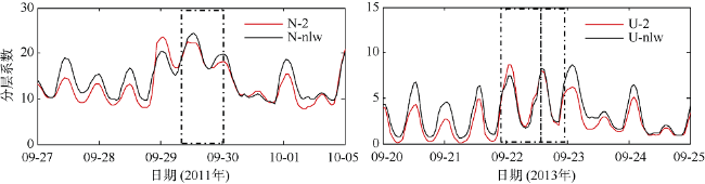
As global warming intensifies, the intensity of typhoon and the number of powerful typhoons have been increasing, which exacerbate the changing situation of salty tide disaster in the Modaomen Waterway. A three-dimensional baroclinic model was applied with SCHISM (semi-implicit cross-scale hydroscience integrated system model) in the Modaomen Waterway to analyze the effect of typhoon path on saltwater intrusion. Taking Typhoon Nesat (the west-path typhoon) and Typhoon Usagi (the east-path typhoon) as examples, different dynamic responses of saltwater transport and stratification were revealed. The east-path typhoon led to the set-down of coastal sea level, which increased the oceanward advective flux. However, the west-path typhoon led to the set-up of coastal sea level, which promoted the oceanward advective flux landward and caused more serious saltwater intrusion. Apart from the effect on coastal sea level, typhoons also cause strong local winds, which have important influences on velocity field and saltwater transport. The up-estuary local wind caused by the west-path typhoon tended to reduce stratification and increase the oceanward advective flux. However, the down-estuary local wind caused by the east-path typhoon tended to enhance stratification under moderate wind, but it reduced stratification when the wind stress increased.
Key words: saltwater intrusion; typhoon path; numerical model; Modaomen Waterway
PAN Mingjie , KONG Jun , YANG Fang , LUO Zhaoyang , ZHANG Weisheng , JING Li , WANG Qing , LI Zhanchen . The particular influence caused by typhoon path on salt intrusion in the Modaomen Waterway, China[J]. Journal of Tropical Oceanography, 2019 , 38(3) : 53 -67 . DOI: 10.11978/2018081
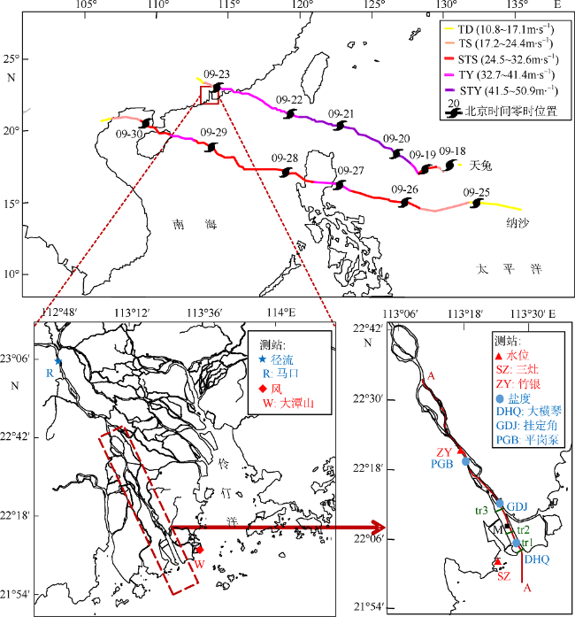
图1 研究区域及台风路径图TD: 热带低压; TS: 热带风暴; STS: 强热带风暴; TY: 台风; STY: 强台风; tr1、tr2、tr3为所选横断面; M为所选分析点; A-A为所选纵断面 Fig. 1 Map of the study area and typhoon tracks (TD: tropical depression; TS: tropical storm; STS: severe tropical storm; TY: typhoon; STY: severe typhoon; tr1, tr2 and tr3 are the selected cross sections; M is the selected analysis point; A-A is the selected along section) |
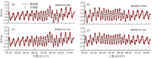
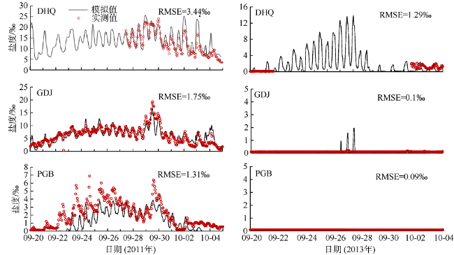
图5 纳沙(2011年)、天兔(2013年)期间不同测站实测和模拟水位对比图Fig. 5 Water level comparison between observed (red) and predicted (black) at different stations during Nesat (2011) and Usagi (2013) |
表1 数值试验汇总表Tab. 1 Summary of numerical experiments performed |
| 试验 | 路径 | 径流量/(m3·s-1) | 风况 |
|---|---|---|---|
| N-1 | 纳沙 | 1000 | 全局风 |
| U-1 | 天兔 | 1000 | 全局风 |
| N-2 | 纳沙 | 2000 | 全局风 |
| U-2 | 天兔 | 2000 | 全局风 |
| N-3 | 纳沙 | 3000 | 全局风 |
| U-3 | 天兔 | 3000 | 全局风 |
| N-4 | 纳沙 | 4000 | 全局风 |
| U-4 | 天兔 | 4000 | 全局风 |
| N-6 | 纳沙 | 6000 | 全局风 |
| U-6 | 天兔 | 6000 | 全局风 |
| N-8 | 纳沙 | 8000 | 全局风 |
| U-8 | 天兔 | 8000 | 全局风 |
| N-nlw | 纳沙 | 2000 | 无局地风 |
| U-nlw | 天兔 | 2000 | 无局地风 |
| N-nw | 纳沙 | 实测流量过程 | 去除台风作用(即9月28日至10月1日期间无风) |
注: “无局地风”即磨刀门水道三维模型没有风输入 |
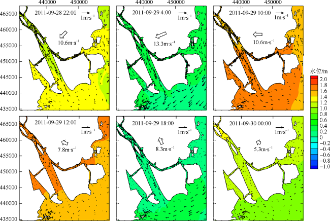
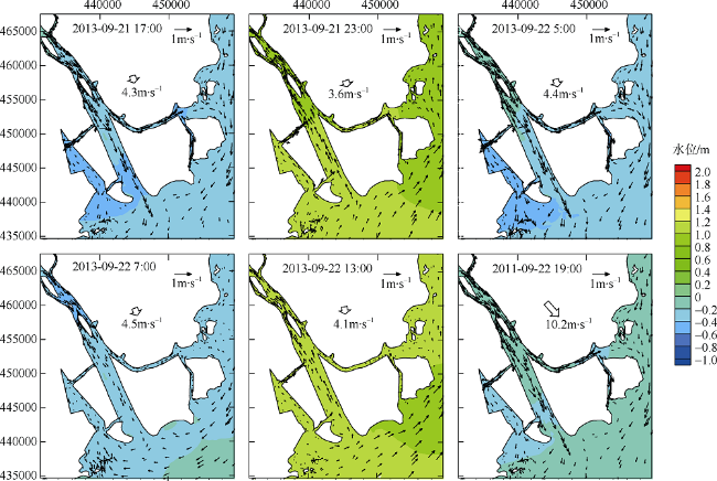
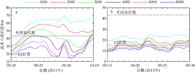
图7 2000m3·s-1 流量下纳沙期间磨刀门水道水位和水深平均流速过程图空心箭头表示风速 Fig. 7 Horizontal distribution of water level and depth-integrated velocity with 2000 m3·s-1 river discharge during Nesat (2011) in the Modaomen Waterway (the hollow arrows specifying wind speed) |
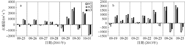
图9 2000m3·s-1流量下纳沙(a)、天兔(b)期间横断面 tr1、tr2和tr3的半日平均水体积输运正值表示向海, 负值表示向陆 Fig. 9 Tidally-averaged volumetric transport of transects at half-day interval with 2000 m3·s-1 river discharge during Nesat (2011) and Usagi (2013), with positive value for seaward and negative value for landward |
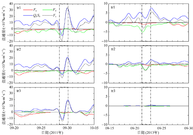
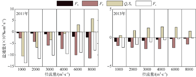
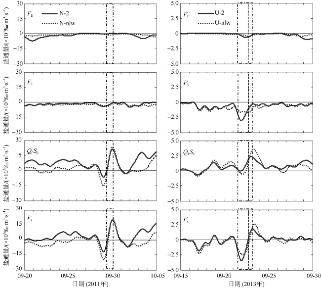
图11 2000m3·s-1流量下纳沙(左)、天兔(右)期间的盐通量33h滤波, 正值表示向海, 负值表示向陆, 虚线框表示台风影响阶段; FE、FT、QFS0、FS分别指剪切扩散盐通量、潮汐震荡盐通量、平流输运盐通量和总盐通量 Fig. 11 Temporal changes of 33-h low-pass-filtered salt flux transects with 2000 m3·s-1 river discharge during Nesat (2011) and Usagi (2013). Positive value means seaward, negative value means landward, and the dashed box marks the typhoon effect period; FE、FT、QFS0、FS refer to the steady shear salt flux, the tidal oscillatory salt flux, the advective salt flux and the net salt flux, respectively |
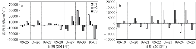
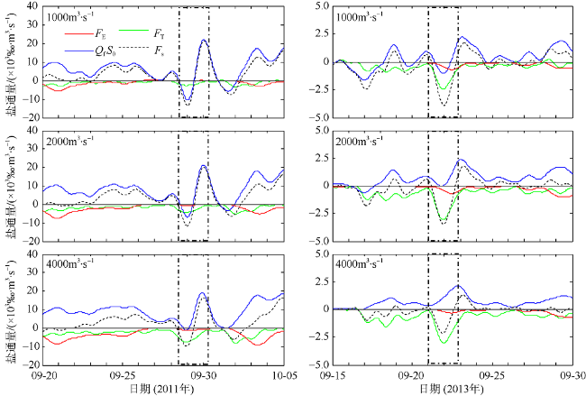
图12 1000、2000、4000m3·s-1流量下纳沙(左)、天兔(右)期间断面2盐通量图(33h滤波)Fig. 12 Temporal changes of 33-h low-pass-filtered salt flux transects with 1000, 2000 and 4000 m3·s-1 river discharges during Nesat (2011) and Usagi (2013) |
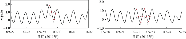
图15 纳沙(2011年)、天兔(2013年)期间选取分析的时刻标志a、b、c、d分别对应涨憩、落急、落憩、涨急四个时刻 Fig. 15 The moment of selected tidal cycle during Nesat (2011) and Usagi (2013) with a, b, c, and d represent flood slack, maximum ebb, ebb slack, and maximum flood, respectively |
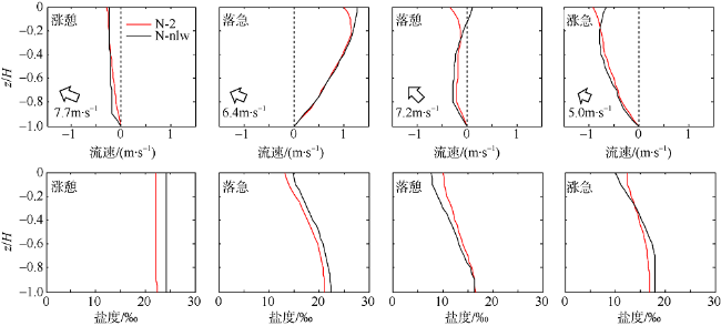
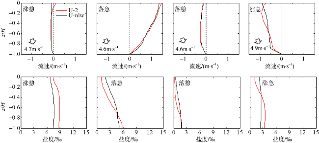
图16 纳沙(2011年)期间有无局地风条件下(N-2和N-nlw)水道M点垂线流速、盐度分布图中虚线为流速方向区分线, 流速正值表示向海, 负值表示向陆; z为水深值, H为总水深值 Fig. 16 Comparison of vertical velocity and salinity distribution of up-estuary wind case (N-2) and no local wind case (N-nlw) during selected tidal cycle in the Nesat (2011) The dotted line in the figure is the velocity direction distinguishing line, positive value of velocity means seaward, and negative value means landward; z is the water depth value and H is the total water depth value |
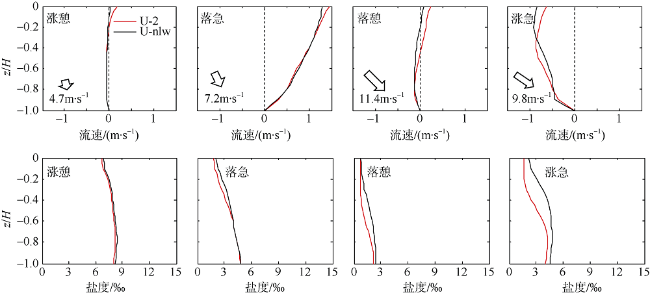
图17 天兔(2013年)期间有无局地风条件下(U-2和U-nlw)第一阶段水道M点垂线流速、盐度分布Fig. 17 Comparison of vertical velocity and salinity distribution of the moderate down-estuary wind case (U-2) and no local wind case (U-nlw) during the first selected tidal cycle in the Usagi (2013) |
The authors have declared that no competing interests exist.
作者已声明无竞争性利益关系。
| [1] |
吕爱琴, 杜文印 , 2006. 磨刀门水道咸潮上溯成因分析[J]. 广东水利水电, ( 5):50-53.
|
| [2] |
叶荣辉, 钱燕, 孔俊 , 等, 2013. 珠江三角洲大系统风暴潮数学模型建立与验证[J]. 人民长江, 44(21):76-80.
|
| [3] |
|
| [4] |
|
| [5] |
|
| [6] |
|
| [7] |
|
| [8] |
|
| [9] |
|
| [10] |
|
| [11] |
|
| [12] |
|
| [13] |
|
| [14] |
|
| [15] |
|
| [16] |
|
| [17] |
|
| [18] |
|
| [19] |
|
/
| 〈 |
|
〉 |
