
热带海洋学报 ›› 2026, Vol. 45 ›› Issue (3): 174-187.doi: 10.11978/2025119CSTR: 32234.14.2025119
南流江河口红树林潮滩沉积物碳含量的空间分异特征
黄春梅1( ), 王日明1(), 谢晓雯2, 戴志军3, 谢小魁1, 李兴荣4
- 1
北部湾大学 ,广西北部湾海洋环境变化与灾害研究重点实验室/资源与环境学院
2南宁师范大学 ,北部湾环境演变与资源利用教育部重点实验室
3华东师范大学 ,河口海岸学国家重点实验室
4中交第四航务工程勘察设计院有限公司
-
收稿日期:2025-07-30修回日期:2025-09-12出版日期:2026-05-10发布日期:2026-05-28 -
通讯作者:王日明(1971—), 男, 湖南省邵阳市人, 博士, 教授, 主要研究方向为滨海景观生态修复。email: wangriming@bbgu.edu.cn -
作者简介:黄春梅(2000—), 女, 贵州省毕节市人, 主要研究方向为滨海景观生态修复。email: 15761472038@163.com
-
基金资助:国家自然科学基金项目(42366009); 国家自然科学重点基金项目(41930537)
Spatial heterogeneity of carbon content in sediments from mangrove tidal flats at the Nanliu River estuary
HUANG Chunmei1(), WANG Riming1(), XIE Xiaowen2, DAI Zhijun3, XIE Xiaokui1, LI Xingrong4
- 1
Guangxi Key Laboratory of Marine Environmental Change and Disaster in Beibu Gulf /College of Resources and Environment ,Beibu Gulf University
2Key Laboratory of Environmental Change and Resource Use in Beibu Gulf ,Ministry of Education, Nanning Normal University
3State Key Laboratory of Estuarine and Coastal Research ,East China Normal University
4CCCC-FHDI Engineering Co. ,Ltd.
-
Received:2025-07-30Revised:2025-09-12Online:2026-05-10Published:2026-05-28 -
Contact:WANG Riming, email: wangriming@bbgu.edu.cn -
Supported by:National Natural Science Foundation of China(42366009); Key Program of the National Natural Science Foundation of China(41930537)
摘要:
红树林作为重要的海洋蓝碳生态系统, 其沉积物碳含量具有显著的时空变异性, 这给其碳储量精准评估带来重要挑战。本研究选择南流江河口桐花树潮滩作为研究对象, 采集表层1~5cm厚的沉积物样品74个, 以系统分析不同植被覆盖区表层沉积物碳含量及其空间分布特征。结果表明: (1)桐花树潮滩沉积物碳含量存在显著空间分异: 基于林缘距离梯度分析显示, 碳含量自陆向海依次为林内区域(1.01±0.17)%>近林区域(0.58±0.16)%>远林区域(0.52±0.19)%; 同时, 不同生物地貌单元间碳含量差异显著, 表现为茂密林区(0.99±0.19)%>幼苗区(0.68±0.23)%>裸滩区(0.49±0.12)%, 分布格局与地上植被植株高度耦合; (2)桐花树潮滩沉积物碳含量主要受沉积物细颗粒物质、植被群落结构特征以及有机质输入情况等关键环境因子调控; (3)区域不同碳输入的差异是引起红树林潮滩碳含量空间分异的基础, 裸滩区以水体携带的碳通过悬沙落淤产生的物理沉积为主, 林区则受细颗粒截留、落叶凋零产生的有机质输入和土壤氧化还原环境共同影响。林外潮滩因红树林聚集生长效应和伴生植被作用可形成局部碳富集。研究结果可为红树林生态修复和蓝碳储存提供部分理论支撑, 为海岸带碳汇评估建立科学基础。
中图分类号:
- P736.41
引用本文
黄春梅, 王日明, 谢晓雯, 戴志军, 谢小魁, 李兴荣. 南流江河口红树林潮滩沉积物碳含量的空间分异特征[J]. 热带海洋学报, 2026, 45(3): 174-187.
HUANG Chunmei, WANG Riming, XIE Xiaowen, DAI Zhijun, XIE Xiaokui, LI Xingrong. Spatial heterogeneity of carbon content in sediments from mangrove tidal flats at the Nanliu River estuary[J]. Journal of Tropical Oceanography, 2026, 45(3): 174-187.
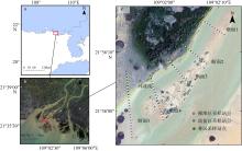
图1
研究区域与河口沙洲位置 a: 北部湾地区(局部) b: 南流江河口 c: 七星岛岛尾潮滩及实验断面设置。图 a 基于自然资源部标准地图网站下载的审图号为 GS(2024) 0650 号的标准地图制作, 底图无修改; 矢量地图来源于地理空间数据云, 卫星影像图来源于四维地球"
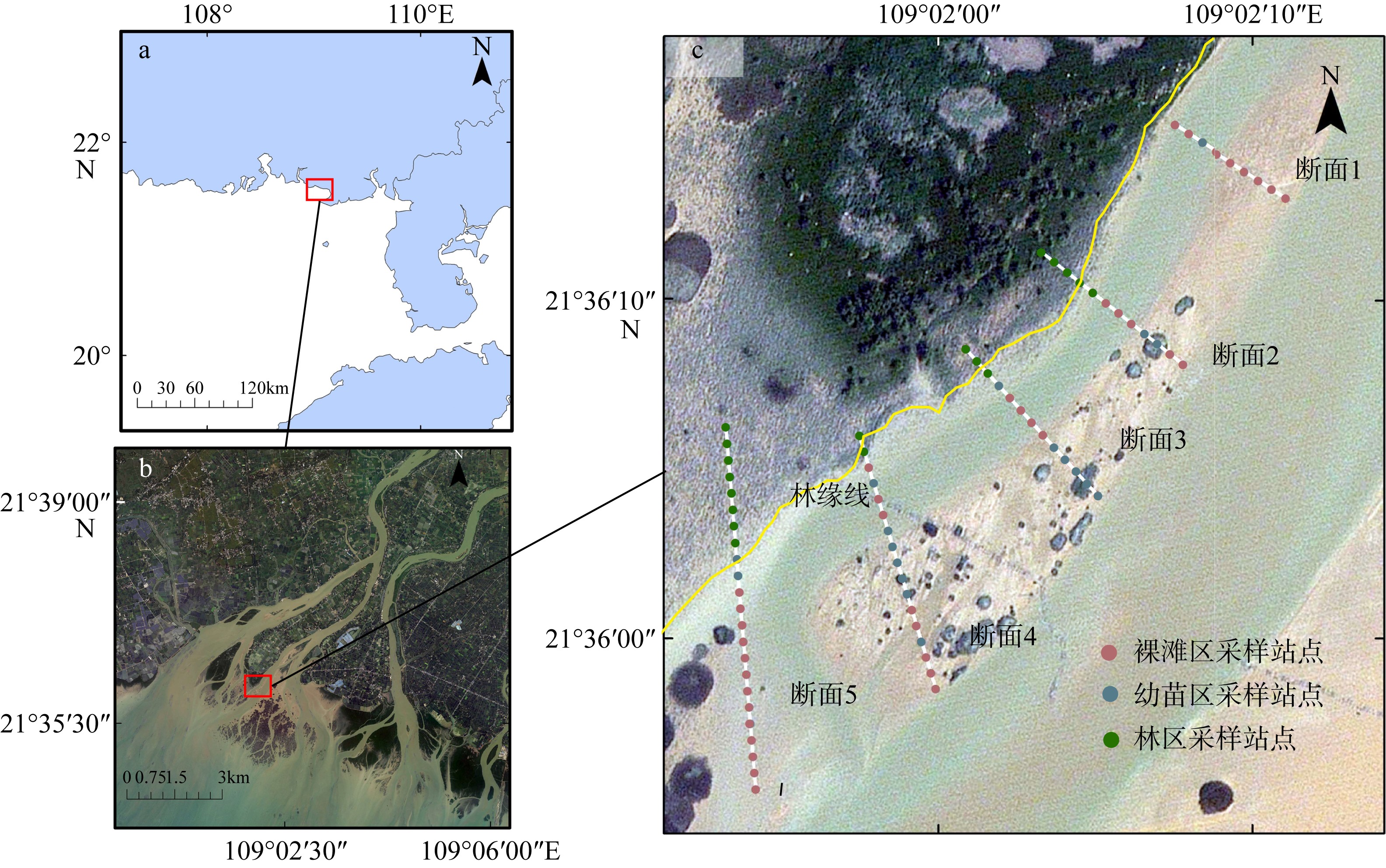
图1

图2
桐花树潮滩植被空间分异格局"
图2
图3
桐花树潮滩不同区域沉积物组分差异性分析 不同小写字母表示不同生物地貌单元沉积物对应组分含量在P<0.01水平上差异显著性"
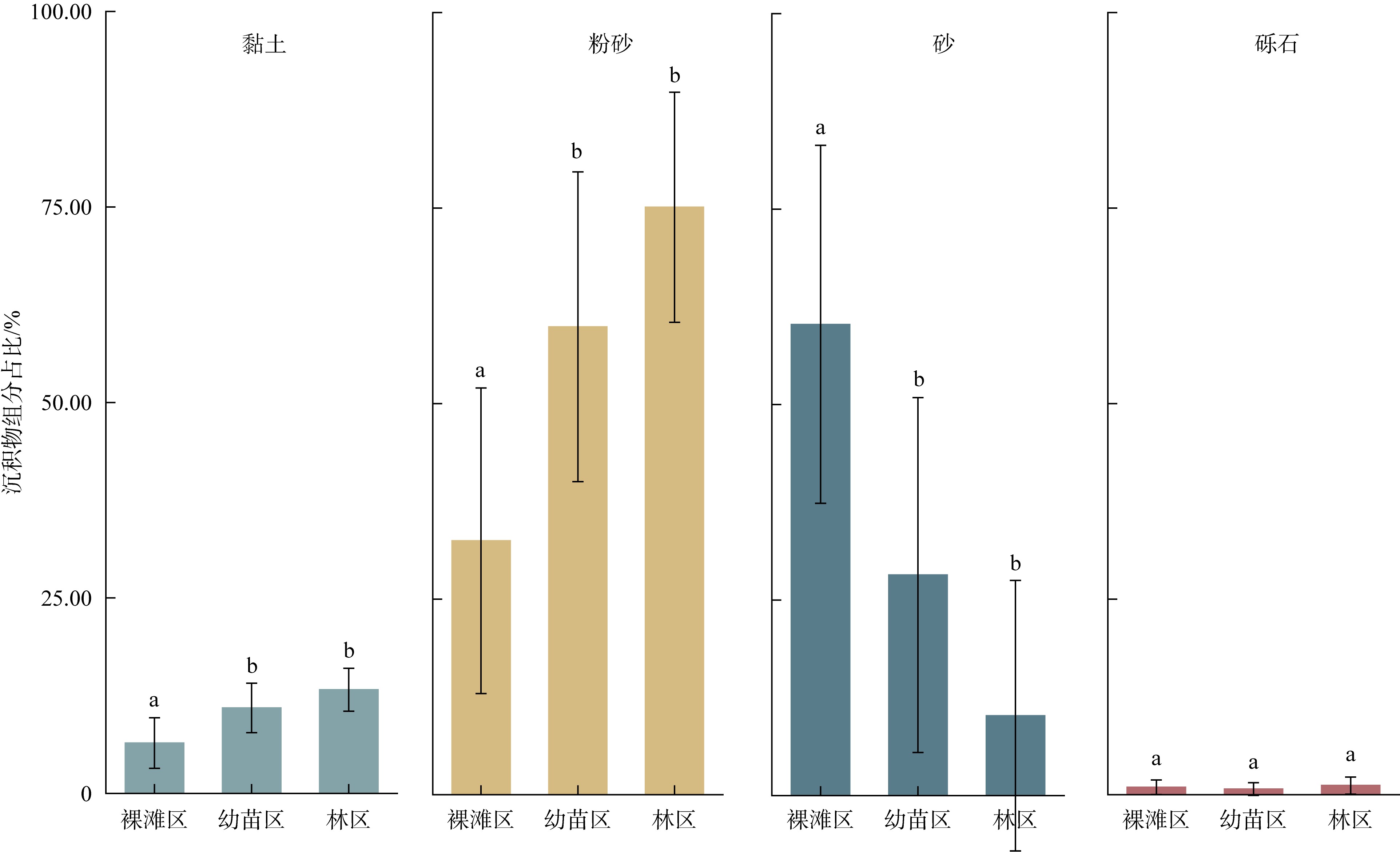
图3
图4
桐花树潮滩不同区域沉积物三元相图"
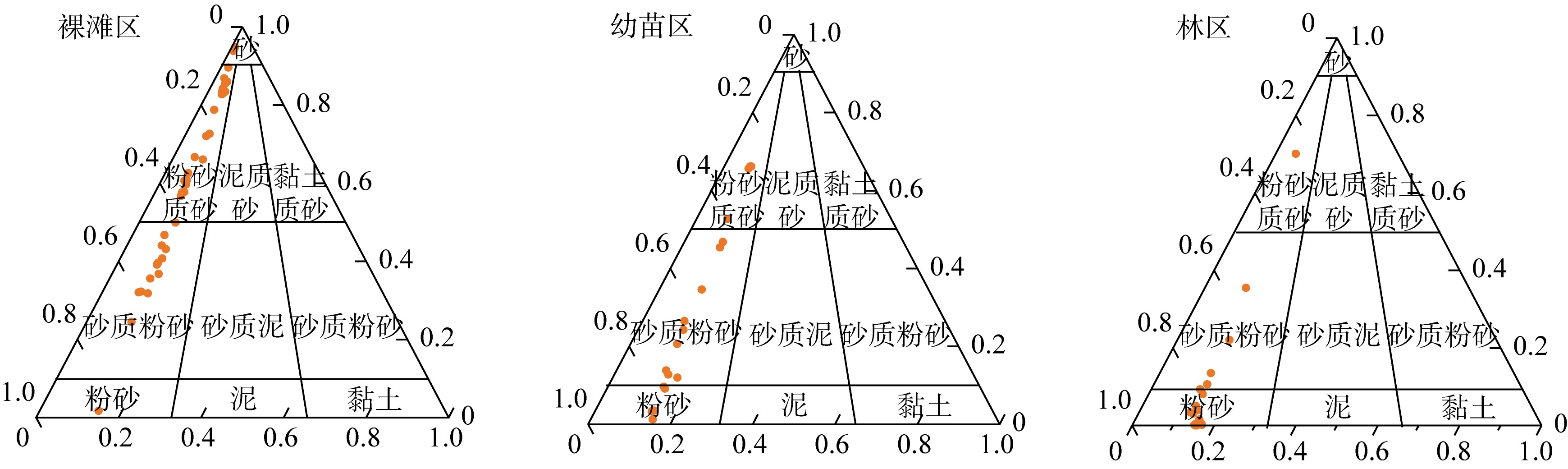
图4
表1
桐花树潮滩不同生物地貌单元沉积物碳含量统计"
| 不同区域 | 最大值/% | 最小值/% | 平均值/% |
|---|---|---|---|
| 裸滩区 | 0.789 | 0.263 | 0.493±0.117a |
| 幼苗区 | 1.091 | 0.393 | 0.682±0.226b |
| 林区 | 1.440 | 0.699 | 0.990±0.186c |
表1
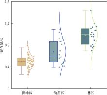
图5
桐花树潮滩不同区域沉积物碳含量分析"

图5

图6
桐花树潮滩沉积物碳含量与粒径特征的空间关联分析"
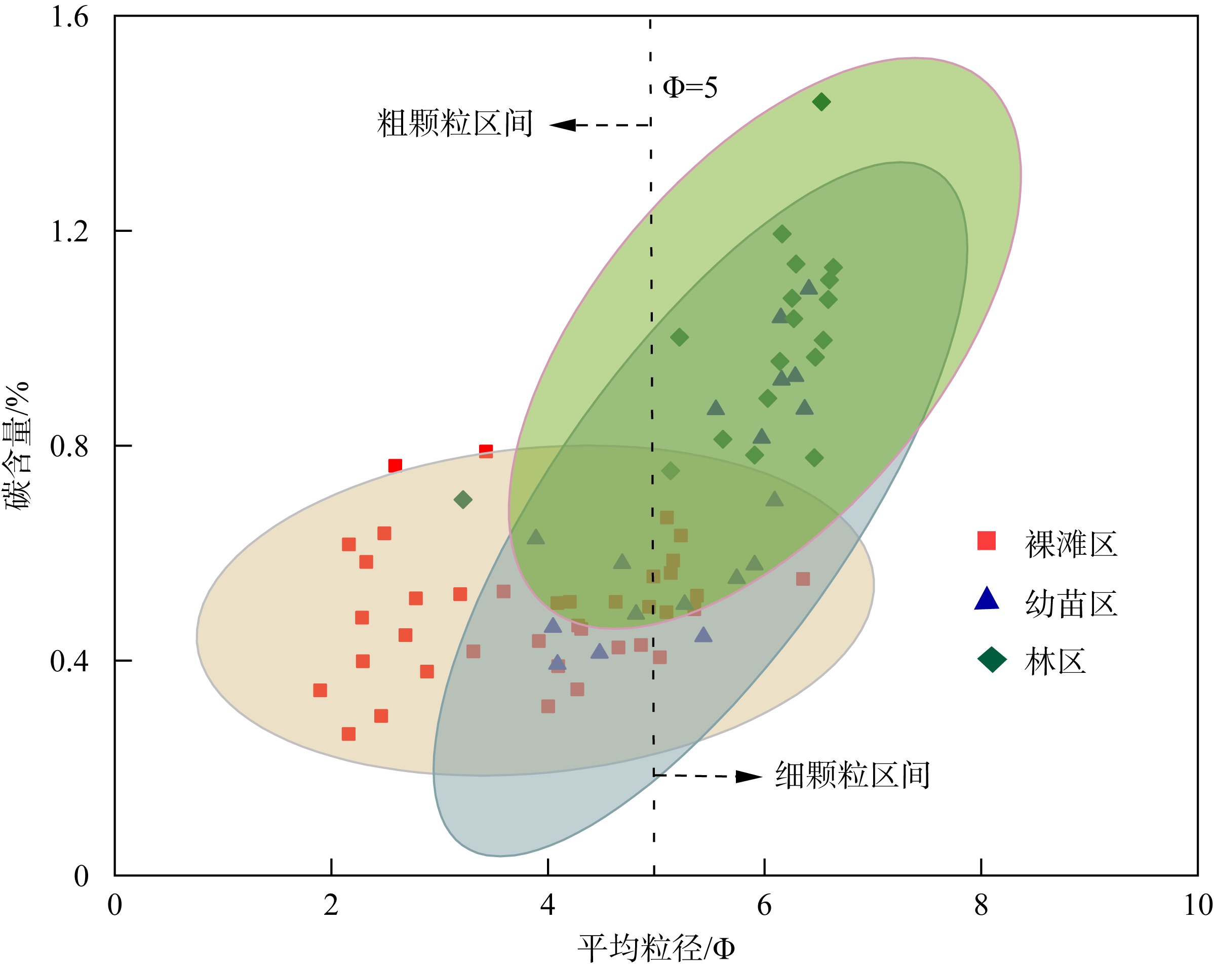
图6
表2
桐花树潮滩不同分区沉积物碳含量统计"
| 测量项目 | 林内区域(n=17) | 近林区域(n=32) | 远林区域(n=25) |
|---|---|---|---|
| 沉积物总碳含量/% | 1.014±0.171a | 0.580±0.164b | 0.522±0.191b |
表2
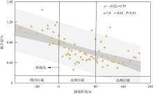
图7
桐花树潮滩沉积物碳含量随林缘距离变化分析"
图7
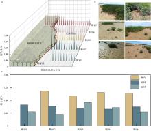
图8
桐花树潮滩沉积物碳储量的空间分布与断面变化规律分析 a. 桐花树潮滩沉积物碳含量空间分布; b. 裸滩区碳含量异常高点实地调查照片(部分); c. 桐花树潮滩各断面沉积物碳含量分析"

图8
图9
桐花树潮滩沉积物各组分与碳含量相关性分析"
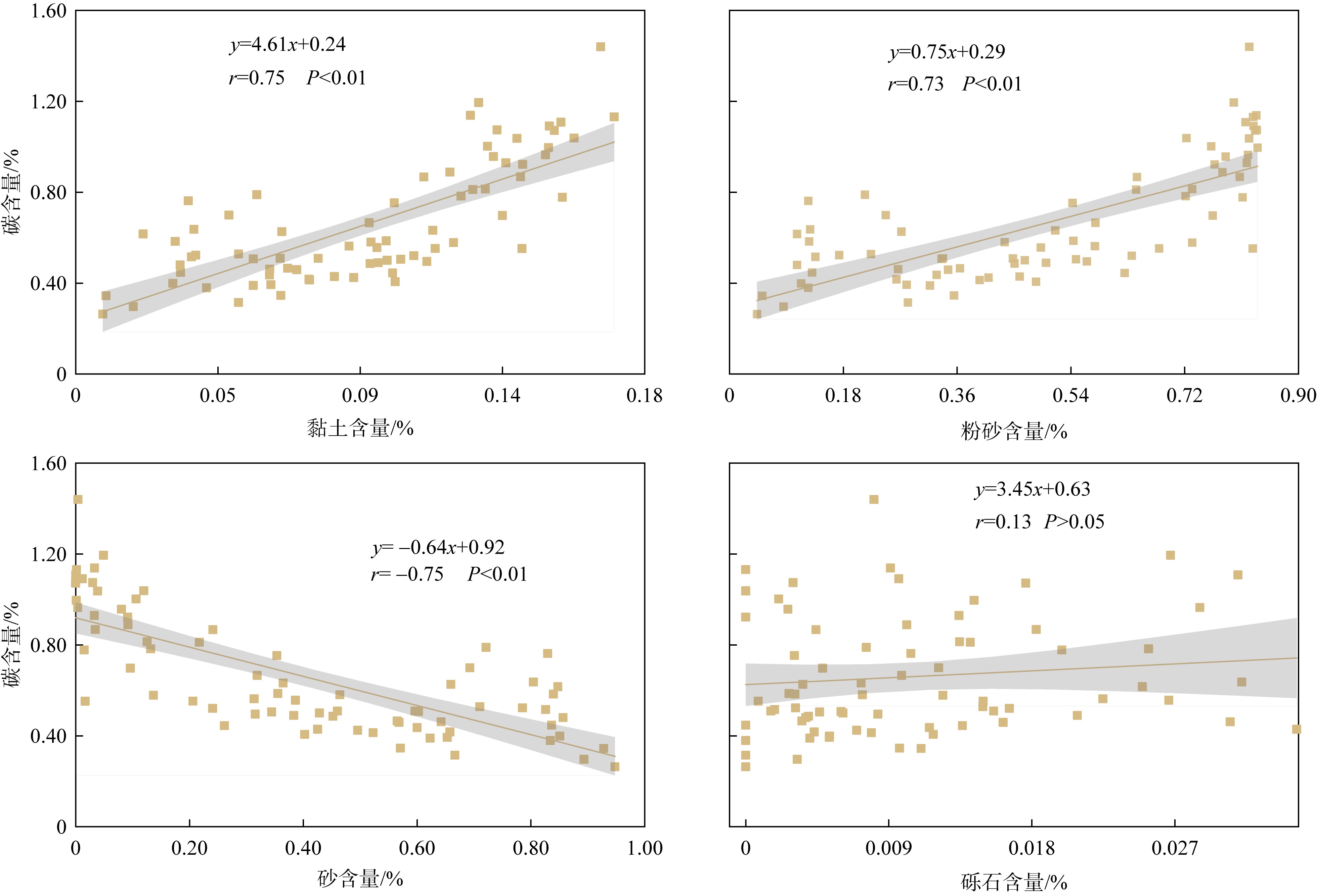
图9
表3
桐花树潮滩不同植被覆盖区地上生物量调查"
| 测量项目 | 裸滩区(n=38) | 幼苗区(n=18) | 林区(n=18) |
|---|---|---|---|
| 植被密度/(plants·m-2) | 0.000 | 0.224 | 1.244 |
| 数目/棵 | 0.000 | 5.600 | 31.111 |
| 高度/cm | 0.000 | 71.360 | 103.098 |
| 基径/cm | 0.000 | 20.120 | 12.941 |
| 冠幅/cm | 0.000 | 79.325 | 60.189 |
| 单株地上生物量/g | 0.000 | 1403.352 | 1167.333 |
| 生物量密度/(g·m-2) | 0.000 | 314.351 | 1516.923 |
表3
图10
桐花树群落演化过程中沉积物碳累积过程"
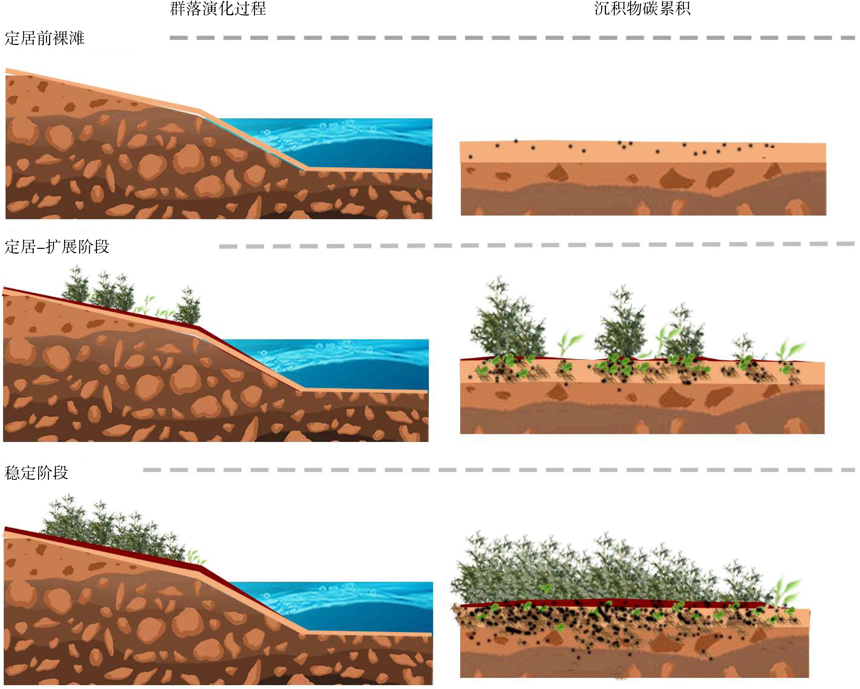
图10
表4
桐花树潮滩不同植被覆盖区沉积物组分与碳含量相关性统计"
| 沉积物组分 | ||||
|---|---|---|---|---|
| 黏土 | 粉砂 | 砂 | 砾石 | |
| 裸滩区 | 0.264 | 0.205 | -0.222 | 0.302 |
| 幼苗区 | 0.864* | 0.736* | -0.753* | -0.156 |
| 林区 | 0.639* | 0.628* | -0.632* | 0.069 |
表4
| [1] |
曹磊, 宋金明, 李学刚, 等, 2013. 滨海盐沼湿地有机碳的沉积与埋藏研究进展[J]. 应用生态学报, 24(7): 2040-2048.
|
|
|
|
| [2] |
陈怀璞, 张天雨, 葛振鸣, 等, 2017. 崇明东滩盐沼湿地土壤碳氮储量分布特征[J]. 生态与农村环境学报, 33(3): 242-251.
|
|
|
|
| [3] |
胡刚, 黎洁, 覃盈盈, 等, 2018. 广西北仑河口红树植物种群结构与动态特征[J]. 生态学报, 38(9): 3022-3034.
|
|
|
|
| [4] |
黄鹄, 戴志军, 盛凯, 2011. 广西北海银滩侵蚀及其与海平面上升的关系[J]. 台湾海峡, 30(2): 275-279.
|
|
|
|
| [5] |
何琴飞, 郑威, 黄小荣, 等, 2017. 广西钦州湾红树林碳储量与分配特征[J]. 中南林业科技大学学报, 37(11): 121-126.
|
|
|
|
| [6] |
江鎞倩, 李瑞利, 沈小雪, 等, 2022. 红树植物耐盐-耐淹性的荟萃分析及其应用对策[J]. 北京大学学报(自然科学版), 58(4): 687-699.
|
|
|
|
| [7] |
廖宝文, 2010. 三种红树植物对潮水淹浸与水体盐度适应能力的研究[D]. 北京: 中国林业科学研究院.
|
|
|
|
| [8] |
林家洋, 宋哲岳, 李自民, 等, 2023. 滨海湿地碳汇和碳负排放技术研究进展[J]. 湿地科学, 21(2): 302-311.
|
|
|
|
| [9] |
林鹏, 1997. 中国红树林生态系[M]. 北京: 科学出版社 (in Chinese).
|
| [10] |
刘婷, 鲍锟山, 周种乐, 等, 2025. 广东海丰红树林湿地140年来有机碳累积过程和来源解析[J]. 第四纪研究, 45(3): 752-765.
|
|
|
|
| [11] |
刘雨薇, 于培松, 郑旻辉, 等, 2023. 不同植被类型对淤泥质潮滩有机碳来源和储量的影响: 以茅埏岛为例[J]. 海洋学研究, 41(4): 94-101.
doi: 10.3969/j.issn.1001-909X.2023.04.009 |
|
doi: 10.3969/j.issn.1001-909X.2023.04.009 |
|
| [12] |
缪绅裕, 陈桂珠, 李海生, 2007. 红树林植物桐花树和白骨壤及其湿地系统[M]. 广州: 中山大学出版社 (in Chinese).
|
| [13] |
彭逸生, 庄雪茵, 赵丽丽, 等, 2023. 树种选择和滩地高程对红树林修复早期系统碳储量的影响[J]. 中山大学学报(自然科学版)(中英文), 62(2): 37-46.
|
|
|
|
| [14] |
宋雪, 王辉, 石建娅, 等, 2022. 深圳湾困难立地红树林修复技术与应用研究[J]. 北京大学学报(自然科学版), 58(5): 929-936.
|
|
|
|
| [15] |
王日明, 戴志军, 黄鹄, 等, 2021. 南流江河口桐花树生物动力地貌过程研究[J]. 海洋学报, 43(9): 102-114.
|
|
|
|
| [16] |
王日明, 梁喜幸, 周晓妍, 等, 2022. 钦江河口潮滩红树林群落空间分布[J]. 遥感学报, 26(6): 1143-1154.
|
|
|
|
| [17] |
吴天亮, 戴志军, 王日明, 等, 2023. 淹水时长与盐度对桐花树胚胎萌根与生长发育过程的影响研究[J]. 海洋学报, 45(11): 101-111.
|
|
|
|
| [18] |
徐蒂, 廖宝文, 朱宁华, 等, 2014. 海南东寨港红树林退化原因初探[J]. 生态科学, 33(2): 294-300.
|
|
|
|
| [19] |
杨慧荣, 方畅, 高均超, 等, 2023. 红树林沉积物微生物空间分布特征及碳汇能力评估[J]. 中山大学学报(自然科学版)(中英文), 62(2): 28-36.
|
|
|
|
| [20] |
杨娟,
|
|
|
|
| [21] |
张莉, 郭志华, 李志勇, 2013. 红树林湿地碳储量及碳汇研究进展[J]. 应用生态学报, 24(4): 1153-1159.
|
|
|
|
| [22] |
赵华显, 阎冰, 徐悦, 等, 2020. 北部湾红树林沉积物中微生物群落结构的时空变化分析[J]. 基因组学与应用生物学, 39(5): 2161-2169.
|
|
|
|
| [23] |
中华人民共和国生态环境部, 2011. 土壤有机碳的测定重铬酸钾氧化-分光光度法HJ615—2011[S]. 北京: 中国环境科学出版社.
|
|
Ministry of Environmental Protection of the People’s Republic of China, 2011. Soil-Determination of Organic Carbon-Potassium Dichromate Oxidation:HJ615—2011[S]. Beijing: China Environmental Science Press. (in Chinese)
|
|
| [24] |
中国海湾志编纂委员会, 1998. 中国海湾志-第十四分册-重要河口[M]. 北京: 海洋出版社 (in Chinese).
|
| [25] |
周元慧, 张忠华, 黎洁, 等, 2020. 广西北仑河口红树植物叶片和土壤的碳氮磷生态化学计量特征[J]. 地球与环境, 48(1): 58-65.
|
|
|
|
| [26] |
|
| [27] |
|
| [28] |
doi: 10.1146/annurev-marine-010213-135020 pmid: 24405426 |
| [29] |
doi: 10.3390/jmse8100767 |
| [30] |
|
| [31] |
doi: 10.1016/j.foreco.2018.03.044 |
| [32] |
doi: 10.1002/ecs2.2017.8.issue-6 |
| [33] |
doi: 10.3389/fmars.2022.900896 |
| [34] |
|
| [35] |
doi: 10.1080/00288306.1970.10418211 |
| [36] |
doi: 10.3389/fmars.2024.1410183 |
| [37] |
|
| [38] |
doi: 10.3390/f11090981 |
| [39] |
doi: 10.1007/s11356-016-6086-6 |
| [40] |
doi: 10.1016/j.aquabot.2007.12.005 |
| [41] |
doi: 10.1016/j.quaint.2016.02.065 |
| [42] |
doi: 10.1016/j.jenvman.2013.11.037 pmid: 24374165 |
| [43] |
doi: 10.1186/s40645-020-00387-3 |
| [44] |
doi: 10.1016/j.foreco.2021.119855 |
| [45] |
doi: 10.1111/ejs.2006.57.issue-4 |
| [46] |
doi: 10.3390/f7060116 |
| [47] |
doi: 10.3390/jmse9090992 |
| [48] |
|
| [49] |
|
| [50] |
doi: 10.1098/rsbl.2018.0237 |
| [51] |
doi: 10.1016/j.catena.2020.104980 |
| [52] |
doi: 10.5194/bg-20-911-2023 |
| [53] |
doi: 10.1126/science.aba2656 pmid: 32499441 |
| [54] |
doi: 10.1038/nature10386 |
| [55] |
doi: 10.3390/f14020421 |
| [56] |
doi: 10.1007/s11274-025-04345-3 |
| [57] |
doi: 10.1016/j.scitotenv.2023.164897 |
| [58] |
doi: 10.1007/s13131-022-2126-x |
| [59] |
doi: 10.1086/622910 |
| [60] |
doi: 10.1016/j.scitotenv.2020.136742 |
| [61] |
doi: 10.1186/s13717-025-00581-5 |
| [62] |
doi: 10.5194/bg-13-4343-2016 |
| [63] |
doi: 10.1016/j.jclepro.2024.143537 |
| [64] |
doi: 10.3390/su14148448 |
| [65] |
doi: 10.3389/fmars.2022.874818 |
| [66] |
doi: 10.1016/j.scitotenv.2022.161168 |
| [1] | 张强, 赵中伟, 苏翔, 赵璇, 李伟. 两种测定海洋沉积物中碳酸盐含量的非器测方法对比分析*[J]. 热带海洋学报, 2026, 45(3): 25-38. |
| [2] | 孟耀文, 蒋艳, 刘旭佳, 蔡德建, 钟声平, 彭银辉, 蔡小辉, 陆洁, 黄国强. 方格星虫对碳和氮稳定同位素的分馏: 养殖试验与滩涂调查[J]. 热带海洋学报, 2026, 45(3): 143-152. |
| [3] | 谭清碧, 郭泓瀛, 孙思旗, 钟宇航, 聂会, 牛丽霞. 稳定同位素示踪浙江清江口红树林沉积物氮源及其影响因子分析[J]. 热带海洋学报, 2026, 45(3): 202-211. |
| [4] | 蒋守殿, 胡鑫, 蓝珮心, 姚李勤, 水柏年, 纪建达, 何茂求. 浙江西门岛红树林细菌群落季节性特征及环境驱动因素[J]. 热带海洋学报, 2026, 45(2): 117-128. |
| [5] | 钟福昌, 向荣, 杨艺萍, 毛华斌. 东北印度洋海岭区表层沉积物底栖有孔虫分布特征及其影响因素初探*[J]. 热带海洋学报, 2026, 45(1): 81-90. |
| [6] | 杜恕环, 向荣, 苏翔, 张兰兰, 潘子锐, 谢金沃, 罗传秀, 万随. 东北印度洋90°E海岭表层沉积物碳酸钙组成与影响因子*[J]. 热带海洋学报, 2026, 45(1): 73-80. |
| [7] | 林明智, 覃茂刚, 陈旸, 陈波, 王雪木, 刘艳锐, 宋家伟, 孙龙飞. Folk分类的海底沉积物类型赋值制图方法研究[J]. 热带海洋学报, 2026, 45(1): 178-187. |
| [8] | 粟春青, 高育慧, 罗炘武, 韩梦梦, 宫彦章, 郑卫国. 深圳不同红树林群落生物量和碳储量[J]. 热带海洋学报, 2025, 44(6): 155-164. |
| [9] | 林明智, 陈波, 陈旸. 适用于海砂勘查的碎屑沉积物分类方法探讨[J]. 热带海洋学报, 2025, 44(6): 165-175. |
| [10] | 陈建勇. 厦门杏林湾沉积物有机质、氮、磷污染空间分布及治理对策[J]. 热带海洋学报, 2025, 44(4): 200-209. |
| [11] | 庞小艳, 李晓琳, 王俊锋, 田新朋, 徐石海, 刘永宏. 印度洋深海来源真菌Penicillium sp. SCSIO 06871次级代谢产物研究[J]. 热带海洋学报, 2024, 43(6): 190-195. |
| [12] | 莫丹杨, 宁志铭, 杨斌, 夏荣林, 刘志金. 涠洲岛珊瑚礁区沉积物硝酸盐异化还原过程对温度变化的响应[J]. 热带海洋学报, 2024, 43(4): 137-143. |
| [13] | 高洁, 余克服, 许慎栋, 黄学勇, 陈飚, 王永刚. 西沙群岛永乐环礁礁外坡沉积物中有机碳的含量与来源分析[J]. 热带海洋学报, 2024, 43(3): 131-145. |
| [14] | 邢楠楠, 任润馨, 唐振洲, 罗志宏, 夏辰曦, 刘永宏, 彭亮, 陈显强. 涠洲岛海洋沉积物来源真菌Aspergillus sp. GXIMD02003的代谢产物研究[J]. 热带海洋学报, 2023, 42(5): 154-160. |
| [15] | 孙翠慈, 岳维忠, 赵文杰, 王友绍. 大亚湾表层沉积物碳水化合物活性酶基因分布特征[J]. 热带海洋学报, 2023, 42(5): 76-91. |
|
||