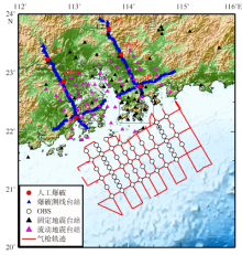
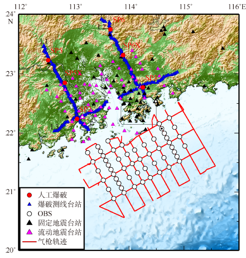
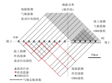
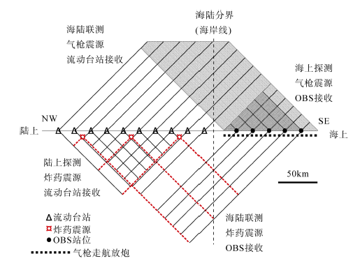
| [1] |
曹敬贺, 孙金龙, 徐辉龙, 等, 2014. 珠江口海域滨海断裂带的地震学特征[J]. 地球物理学报, 57(2): 498-508.
|
|
CAO JINHE, SUN JINLONG, XU HUILONG, et al, 2014. Seismological features of the littoral fault zone in the Pearl River Estuary[J]. Chinese Journal of Geophysics, 57(2): 498-508 (in Chinese).
|
| [2] |
陈恩民, 黄咏茵, 1984. 华南十九次强震暨南海北部陆缘地震带概述[J]. 华南地震, 4(1): 11-32.
|
| [3] |
陈颙, 张先康, 丘学林, 等, 2007. 陆地人工激发地震波的一种新方法[J]. 科学通报, 52(11): 1317-1321.
|
|
CHEN YONG, ZHANG XIANKANG, QIU XUELIN, et al, 2007. A new way to generate seismic waves for continental crustal exploration[J]. Chinese Science Bulletin, 2007, 52(16): 2264-2268 (in Chinese).
|
| [4] |
廖其林, 王振明, 王屏路, 等, 1988. 福州—泉州—汕头地区地壳结构的爆炸地震研究[J]. 地球物理学报, 31(3): 270-280.
|
|
LIAO QILIN, WANG ZHENMING, WNAG PINGLU, et al, 1988. Explosion seismic study of the crustal structure in Fuzhou-Quanzhou-Shantou region[J]. Chinese Journal of Geophysics, 31(3): 270-280 (in Chinese).
|
| [5] |
刘以宣, 钟建强, 詹文欢, 1994. 南海北部陆缘地震带基本特征及区域稳定性初步分析[J]. 华南地震, 14(4): 41-46.
|
|
LIU YIXUAN, ZHONG JIANQIANG, ZHAN WENHUAN, 1994. The Basic characteristics of seismic belts and preliminary analyses of regional stability in north continental margin of South China Sea[J]. South China Journal of Seismology, 14(4): 41-46 (in Chinese).
|
| [6] |
丘学林, 施小斌, 阎贫, 等, 2003a. 南海北部地壳结构的深地震探测和研究新进展[J]. 自然科学进展, 13(3): 231-236.
|
|
QIU XUELIN, SHI XIAOBIN, YAN PIN, et al, 2003a. Recent progress of deep seismic experiments and studies of crustal structure in northern South China Sea[J]. Progress in Natural Science, 13(7): 481-488 (in Chinese).
|
| [7] |
丘学林, 赵明辉, 叶春明, 等, 2003b. 南海东北部海陆联测与海底地震仪探测[J]. 大地构造与成矿学, 27(4): 295-300.
|
|
QIU XUELIN, ZHAO MINGHUI, YE CHUNMING, et al, 2003b. Ocean bottom seismometer and onshore-offshore seismic experiment in northeastern South China Sea[J]. Geotectonica et Metallogenia, 27(4): 295-300 (in Chinese).
|
| [8] |
丘学林, 陈颙, 朱日祥, 等, 2007. 大容量气枪震源在海陆联测中的应用: 南海北部试验结果分析[J]. 科学通报, 52(4): 463-469.
|
|
QIU XUELIN, CHEN YONG, ZHU RIXIANG, et al, 2007. The application of large volume airgun sources to the onshore-offshore seismic surveys: implication of the experimental results in northern South China Sea[J]. Chinese Science Bulletin, 52(4): 553-560 (in Chinese).
|
| [9] |
魏柏林, 冯绚敏, 陈定国, 等, 2001. 东南沿海地震活动特征[M]. 北京: 地震出版社.
|
| [10] |
夏少红, 丘学林, 赵明辉, 等, 2008. 香港地区海陆地震联测及深部地壳结构研究[J]. 地球物理学进展, 23(5): 1389-1397.
|
|
XIA SHAOHONG, QIU XUELIN, ZHAO MINGHUI, et al, 2008. Investigation on deep crustal structure along the onshore-offshore seismic profile near Hongkong[J]. Progress in Geophysics, 23(5): 1389-1397 (in Chinese).
|
| [11] |
赵明辉, 丘学林, 叶春明, 等, 2004a. 南海东北部海陆深地震联测与滨海断裂带两侧地壳结构分析[J]. 地球物理学报, 47(5): 845-852.
|
|
ZHAO MINGHUI, QIU XUELIN, YE CHUNMING, et al, 2004a. An analysis on deep crustal structure along the onshore-offshore seismic profile across the Binhai (littoral) fault zone in northeastern South China Sea[J]. Chinese Journal of Geophysics, 47(5): 845-852 (in Chinese).
|
| [12] |
赵明辉, 丘学林, 夏戡原, 等, 2004b. 南海东北部海陆联测地震数据处理及初步结果[J]. 热带海洋学报, 23(1): 58-63.
|
|
ZHAO MINGHUI, QIU XUELIN, XIA KANYUAN, et al, 2004b. Onshore-offshore seismic data processing and preliminary results in NE South China Sea[J]. Journal of Tropical Oceanography, 23(1): 58-63 (in Chinese).
|
| [13] |
钟建强, 詹文欢, 古森昌, 等, 1996. 珠江三角洲新构造运动与地壳稳定性分析[J]. 华南地震, 16(2): 57-63.
|
|
ZHONG JIANQIANG, ZHAN WENHUAN, GU SENCHANG, et al, 1996. Study on neotectonic movement and crustal stability in Pearl River delta[J]. South China Journal of Seismology, 16(2): 57-63 (in Chinese).
|
| [14] |
钟贻军, 任镇寰, 2003. 1969年阳江6.4级地震发震构造研究[J]. 大地测量与地球动力学, 23(4): 92-98.
|
|
ZHONG YIJUN, REN ZHENHUAN, 2003. Study on seismogenic tectonic of Yangjiang M6.4 earthquake[J]. Journal of Geodesy and Geodynamics, 23(4): 92-98 (in Chinese).
|
| [15] |
COHEN J K, STOCKWELL JR J W, 1995. The SU user’s manual[M]. Mines: Colorado School of Mines: 1-40.
|

 ), 丘学林1,4(