
Journal of Tropical Oceanography ›› 2020, Vol. 39 ›› Issue (1): 106-119.doi: 10.11978/2019020CSTR: 32234.14.2019020
• Marine Geophysics • Previous Articles Next Articles
Constrains of sliding wave phases on the low-velocity layer in the Pearl River Estuary
YANG Bifeng1,2, XIONG Cheng1, CAO Jinghe1, SUN Jinlong1( ), WAN Kuiyuan1, XIA Shaohong1
- 1. CAS Key Laboratory of Ocean and Marginal Sea Geology, South China Sea Institute of Oceanology, Guangzhou 510301, China
2. University of Chinese Academy of Sciences, Beijing 100049, China
-
Received:2019-03-01Revised:2019-04-09Online:2020-01-20Published:2020-01-09 -
Contact:Jinlong SUN E-mail:sunjl@scsio.ac.cn -
Supported by:National Natural Science Foundation of China(41576046);National Natural Science Foundation of China(41506046)
CLC Number:
- P738.4
Cite this article
YANG Bifeng, XIONG Cheng, CAO Jinghe, SUN Jinlong, WAN Kuiyuan, XIA Shaohong. Constrains of sliding wave phases on the low-velocity layer in the Pearl River Estuary[J].Journal of Tropical Oceanography, 2020, 39(1): 106-119.
share this article
Add to citation manager EndNote|Reference Manager|ProCite|BibTeX|RefWorks
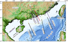
Fig.1
Location map of the onshore-offshore deep seismic survey lines in South China and transition zone. The yellow box is the study area, the purple line is the survey lines of the low-velocity layer, and the red line is the survey line used in this study"
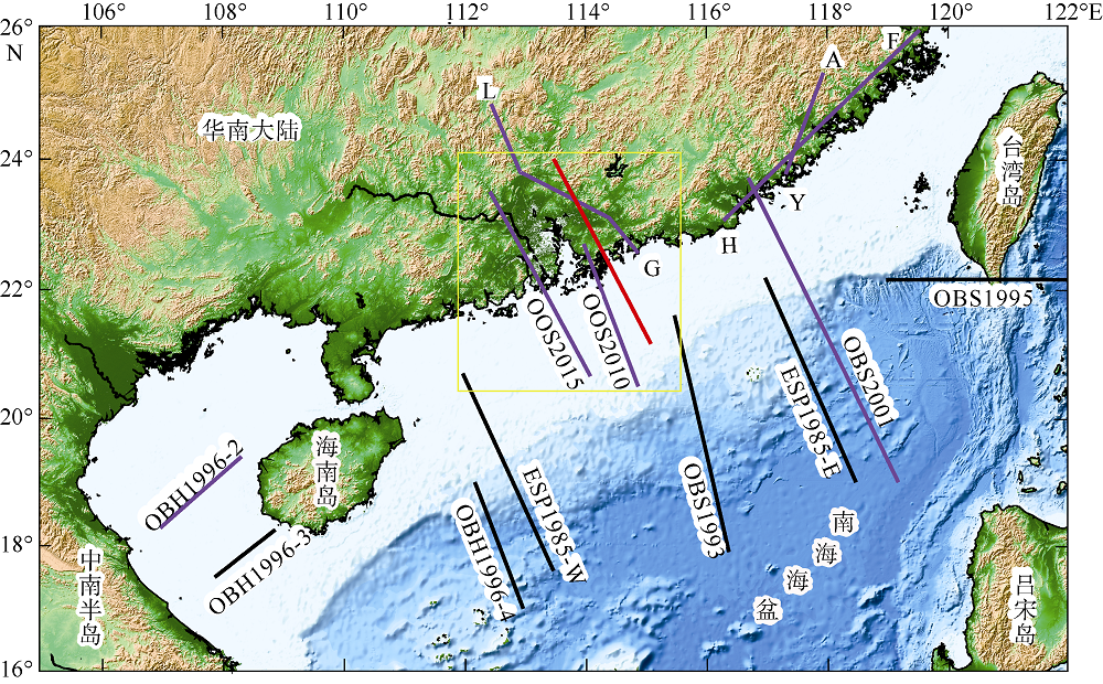
Fig.1
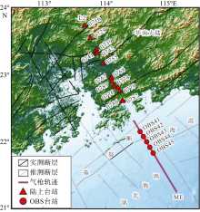
Fig. 2
Distribution of seismic stations along seismic line L2-ME"

Fig. 2
Tab. 1
The number and pick error of different phases"
| 震相 | 拾取数量 | 拾取误差/ms |
|---|---|---|
| Ps | 63 | 50 |
| Pg1 | 2960 | 80 |
| Pg2 | 191 | 80 |
| PmP | 2982 | 100 |
| 合计 | 6196 |
Tab. 1
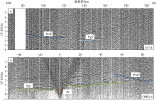
Fig. 3
Pick-up of seismic phase of station 0774 (a) and station OBS44 (b). (T-D/6) is the reduced travel time, T is the value of time, D is the value of offset, and reduced velocity is 6 km·s-1"
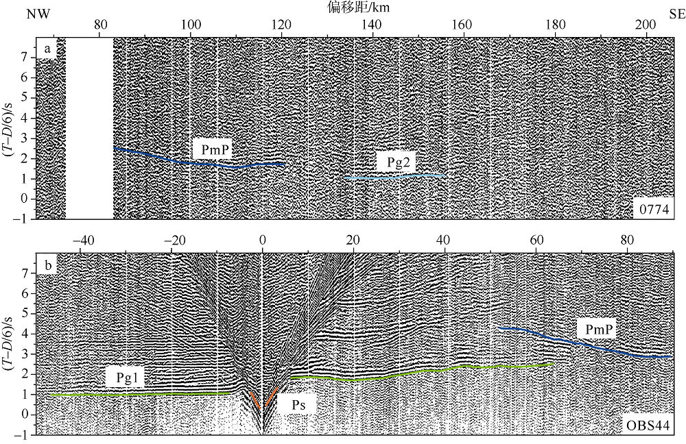
Fig. 3
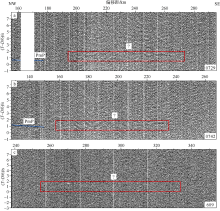
Fig. 4
The unknown phase found in seismic line L2 (a, b) and in seismic line L1 (c, After Xiong (2018)). (T-D/6) is the reduced travel time, T is the value of time, D is the value of offset, and reduced velocity is 6 km·s-1"

Fig. 4
Fig. 5
The initial crustal structure model of the onshore-offshore seismic line L2-ME. The number 2-6 represent different layer and the right side digital represent P-wave velocity of upper and lower interface of each layer"
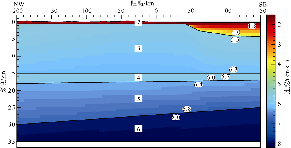
Fig. 5
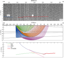
Fig. 6
The contrast of typical seismic phase with unknown phase in calculated travel time of station 0742. (T-D/6) is the reduced travel time, T is the value of time, D is the value of offset, and reduced velocity is 6 km·s-1"

Fig. 6

Fig. 7
The contrast of possible sliding wave phase with unknown phase in calculated travel time of station 0742. (T-D/6) is the reduced travel time, T is the value of time, D is the value of offset, and reduced velocity is 6 km·s-1"

Fig. 7
Tab. 2
Number of travel times, Root Mean Square misfit and normalized χ2 of Ph phases for onshore seismic stations"
| 地震台站 | 分量 | 拾取误差/ms | Ph震相数 | 走时残差/s | χ2 |
|---|---|---|---|---|---|
| 0716 | 垂直 | 80 | 216 | 0.094 | 1.378 |
| 0729 | 垂直 | 50 | 293 | 0.047 | 0.886 |
| 0739 | 垂直 | 50 | 159 | 0.059 | 1.406 |
| 0741 | 垂直 | 80 | 250 | 0.107 | 1.782 |
| 0742 | 垂直 | 50 | 351 | 0.051 | 1.040 |
| 0755 | 垂直 | 80 | 137 | 0.098 | 1.523 |
| 0779 | 垂直 | 80 | 133 | 0.083 | 1.088 |
| 0789 | 垂直 | 80 | 251 | 0.076 | 1.113 |
| 合计 | 1790 |
Tab. 2
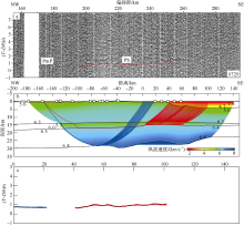
Fig. 8
Seismic record section (a), ray-tracing (b) and travel time fits (c) of station 0729. (T-D/6) is the reduced travel time, T is the value of time, D is the value of offset, and reduced velocity is 6 km·s-1"

Fig. 8

Fig. 9
Seismic record section (a), ray-tracing (b) and travel time fits (c) of station 0742. (T-D/6) is the reduced travel time, T is the value of time, D is the value of offset, and reduced velocity is 6 km·s-1"
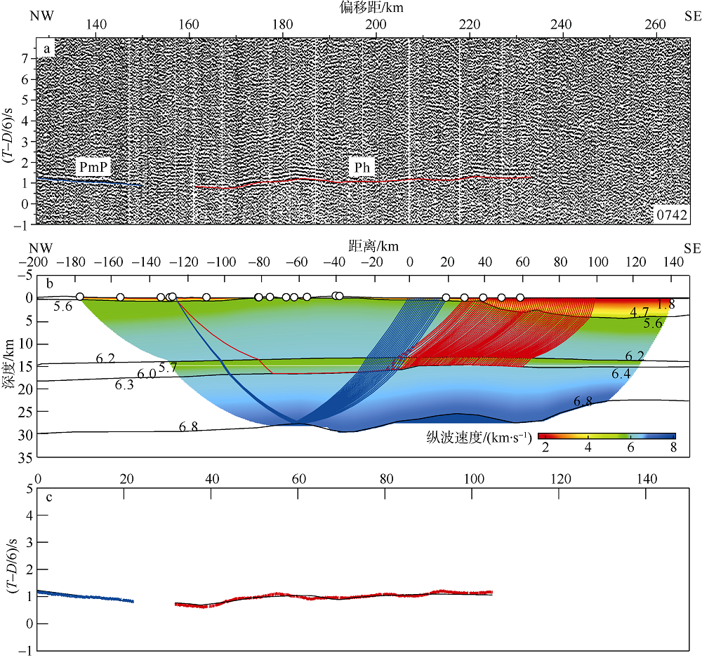
Fig. 9

Fig. 10
Ray-tracing (a) and travel time fits (b) of the sliding wave phase of low-velocity layer in seismic line L2-ME. (T-D/6) is the reduced travel time, T is the value of time, D is the value of offset, and reduced velocity is 6 km·s-1"
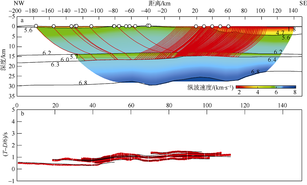
Fig. 10
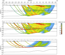
Fig. 11
Distribution of ray coverage density including Ph phases (b) or not (a), and the difference of ray coverage density between the two (c)"

Fig. 11
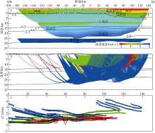
Fig. 12
P-wave velocity structure model (a), ray-tracing (b) and travel time fits (c) of seismic line L2-ME. The dilution ratio of ray in (b) is 5. (T-D/6) is the reduced travel time, T is the value of time, D is the value of offset, and reduced velocity is 6 km·s-1"

Fig. 12
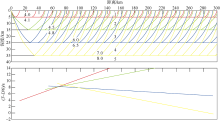
Fig. 13
Ray-tracing and travel time of theoretical sliding wave phase on different velocity discontinuity surfaces. The number 1~5 represent different layer and the left side digital represent P-wave velocity of upper and lower interface of each layer. (T-D/6) is the reduced travel time, T is the value of time, D is the value of offset, and reduced velocity is 6 km·s-1"
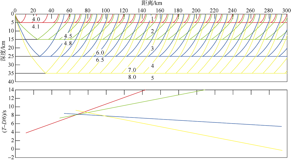
Fig. 13
| [1] | 曹敬贺 , 2014. 南海北部珠江口海域滨海断裂带的地震学特征研究[D]. 北京: 中国科学院大学: 1-133. |
| CAO JINGHE , 2014. Research on seismology of Littoral Fault Zone in the Pearl River Estuary of northern South China Sea[D]. Beijing: University of Chinese Academy of Sciences: 1-133 (in Chinese). | |
| [2] |
曹敬贺, 孙金龙, 徐辉龙 , 等, 2014. 珠江口海域滨海断裂带的地震学特征[J]. 地球物理学报, 57(2):498-508.
doi: 10.6038/cjg20140215 |
|
CAO JINGHE, SUN JINLONG, XU HUILONG , et al, 2014. Seismological features of the littoral fault zone in the Pearl River Estuary[J]. Chinese Journal of Geophysics, 57(2):498-508 (in Chinese with English abstract).
doi: 10.6038/cjg20140215 |
|
| [3] | 陈冰, 王家林, 钟慧智 , 等, 2005. 南海东北部的断裂分布及其构造格局研究[J]. 热带海洋学报, 24(2):42-51. |
| CHEN BING, WANG JIALIN, ZHONG HUIZHI , et al, 2005. A study on fault distribution and tectonic framework in northeastern South China Sea[J]. Journal of Tropical Oceanography, 24(2):42-51 (in Chinese with English abstract). | |
| [4] | 陈剑雄, 王宝善, 葛洪魁 , 等, 2011. 气枪探测资料对华北地区地壳低速带的约束[J]. 中国地震, 27(1):49-55. |
| CHEN JIANXIONG, WANG BAOSHAN, GE HONGKUI , et al, 2011. Using information of airgun to contract the low velocity zone in crustal in North China[J]. Earthquake Research in China, 27(1):49-55 (in Chinese with English abstract). | |
| [5] |
邓阳凡, 李守林, 范蔚茗 , 等, 2011. 深地震测深揭示的华南地区地壳结构及其动力学意义[J]. 地球物理学报, 54(10):2560-2574.
doi: 10.3969/j.issn.0001-5733.2011.10.013 |
|
DENG YANGFAN, LI SHOULIN, FAN WEIMING , et al, 2011. Crustal structure beneath South China revealed by deep seismic soundings and its dynamics implications[J]. Chinese Journal of Geophysics, 54(10):2560-2574 (in Chinese with English abstract).
doi: 10.3969/j.issn.0001-5733.2011.10.013 |
|
| [6] | 丁原章, 黄新辉 , 1998. 珠江三角洲地区未来地震危险性预测[J]. 华南地震, 18(1):56-63. |
| DING YUANZHANG, HUANG XINHUI , 1998. Seismic hazard prediction in the Pearl River Delta Area[J]. South China Journal of Seismology, 18(1):56-63 (in Chinese with English abstract). | |
| [7] | 胡小幸, 林邦慧 , 1989. 邢台地震空间分布随时间变化的立体图象与地震发生过程[J]. 地震学报, 11(1):1-11. |
| HU XIAOXING, LIN BANGHUI , 1989. Stereoscopic figures of the time-variation in the space distribution of foci of the Xingtai earthquakes and their occurrence procedure[J]. Acta Seismologica Sinica, 11(1):1-11 (in Chinese with English abstract). | |
| [8] | 姜本鸿, 袁登维, 吴玉华 , 1992. 壳内低速层与地震活动关系[J]. 地质科技情报, 11(4):9-15. |
| JIANG BENHONG, YUAN DENGWEI, WU YUHUA , 1992. Relation of low-velocity crustal layers with earthquake activities[J]. Geological Science and Technology Information, 11(4):9-15 (in Chinese with English abstract). | |
| [9] | 李秋生 , 1998. 壳内低速层与大陆多震层[J]. 中国地质科学院562综合大队集刊, 13:28-40. |
| LI QIUSHENG , 1998. Intracrustal low-velocity layer and continental seismogenic layer[J]. Bulletin of the 562 Comprehensive Geological Brigade, Chinese Academy of Geological Sciences, 13:28-40 (in Chinese). | |
| [10] | 李松林, 苗琪, 王旭 , 2011. 华北地区的地壳低速层[J]. 大地测量与地球动力学, 31(5):35-38. |
| LI SONGLIN, MIAO QI, WANG XU , 2011. Low velocity layers of the crust in North China[J]. Journal of Geodesy and Geodynamics, 31(5):35-38 (in Chinese with English abstract). | |
| [11] | 李新胜, 周俊乐 , 2007. 声幅-变密度测井原理及测井解释方法[J]. 陕西地质, 25(2):54-59. |
| LI XINSHENG, ZHOU JUNLE , 2007. Principles and interpretation method of acoustic amplitude variable density logging[J]. Geology of Shaanxi, 25(2):54-59 (in Chinese with English abstract). | |
| [12] | 李占咸, 王秀明, 杨建绥 , 等, 1992. 声波测井中几何声学的滑行波理论与波动力学理论的一致性[J]. 大庆石油学院学报, 16(4):1-7. |
| LI ZHANXIAN, WANG XIUMING, YANG JIANSUI , et al, 1992. Coindence between slide wave theory in geometric and wave motion theory[J]. Journal of Daqing Petroleum Institute, 16(4):1-7 (in Chinese with English abstract). | |
| [13] | 林纪曾, 梁国昭, 赵毅 , 等, 1980. 东南沿海地区的震源机制与构造应力场[J]. 地震学报, 2(3):245-257. |
| LIN JIZENG, LIANG GUOZHAO, ZHAO YI , et al, 1980. Focal mechanism and tectonic stress field of coastal southeast China[J]. Acta Seismologica Sinica, 2(3):245-257 (in Chinese with English abstract). | |
| [14] | 刘国栋, 顾群, 史书林 , 等, 1983. 京津唐渤和周围地区地壳上地幔电性结构及其与地震活动性的关系[J]. 地球物理学报, 26(2):149-157. |
| LIU GUODONG, GU QUN, SHI SHULIN , et al, 1983. The electrical structure of the crust and upper mantle and its relationship with seismicity in the Beijing-Tianjin-Tangshan region and adjacent area[J]. Acta Geophysica Sinica, 26(2):149-157 (in Chinese with English abstract). | |
| [15] | 吕作勇, 丘学林, 叶春明 , 等, 2017. 珠江口区域海陆联合三维地震构造探测的数据处理与震相识别[J]. 热带海洋学报, 36(3):80-85. |
| LV ZUOYONG, QIU XUELIN, YE CHUNMING , et al, 2017. Data processing and phase identification of onshore-offshore 3D seismic exploration in Zhujiangkou area[J]. Journal of Tropical Oceanography, 36(3):80-85 (in Chinese with English abstract). | |
| [16] | 宋海斌, 郝天珧, 江为为 , 等, 2002. 南海地球物理场特征与基底断裂体系研究[J]. 地球物理学进展, 17(1):24-34. |
| SONG HAIBIN, HAO TIANYAO, JIANG WEIWEI , et al, 2002. Researches on geophysical field characteristics and basement fault system of South China Sea[J]. Progress in Geophysics, 17(1):24-34 (in Chinese with English abstract). | |
| [17] | 隋志强 , 2008. 声波测井中泥饼折射滑行波分析方法初探[J]. 石油地球物理勘探, 43(3):340-342. |
| SUI ZHIQIANG , 2008. Preliminary analysis on refracted slide wave of mudcake in sonic logging[J]. Oil Geophysical Prospecting, 43(3):340-342 (in Chinese with English abstract). | |
| [18] | 孙武城, 李松林, 罗力雷 , 等, 1987. 初论华北地区的地壳低速层[J]. 地震地质, 9(1):17-26. |
| SUN WUCHENG, LI SONGLIN, LUO LILEI , et al, 1987. A preliminary study on low velocity layer in the crust in North China[J]. Seismology and Geology, 9(1):17-26 (in Chinese with English abstract). | |
| [19] | 滕吉文, 白登海, 杨辉 , 等, 2008. 2008汶川Ms8.0地震发生的深层过程和动力学响应[J]. 地球物理学报, 51(5):1385-1402. |
| TENG JIWEN, BAI DENGHAI, YANG HUI , et al, 2008. Deep processes and dynamic responses associated with the Wenchuan Ms8.0 earthquake of 2008[J]. Chinese Journal of Geophysics, 51(5):1385-1402 (in Chinese with English abstract). | |
| [20] |
滕吉文 , 2010. 强烈地震孕育与发生的地点、时间及强度预测的思考与探讨[J]. 地球物理学报, 53(8):1749-1766.
doi: 10.3969/j.issn.0001-5733.2010.08.001 |
|
TENG JIWEN , 2010. Ponder and research on the genesis and occurrence of strong earthquakes and the prediction of their place, time and intensity[J]. Chinese Journal of Geophysics, 53(8):1749-1766 (in Chinese with English abstract).
doi: 10.3969/j.issn.0001-5733.2010.08.001 |
|
| [21] | 王妙月 , 1994. 板内地震成因与物理预报[J]. 地球物理学报, 37(S1):208-213. |
| WANG MIAOYUE , 1994. Cause and physical prediction of intraplate earthquakes[J]. Acta Geophysica Sinica, 37(S1):208-213 (in Chinese with English abstract). | |
| [22] | 魏柏林 , 2001. 东南沿海地震活动特征[M]. 北京: 地震出版社: 1-516. |
| WEI BOLIN , 2001. Characteristics of earthquakes in southeastern onshore region in China[M]. Beijing: Seismologic Publishing House: 1-516(in Chinese). | |
| [23] | 夏少红, 丘学林, 赵明辉 , 等, 2008. 香港地区海陆地震联测及深部地壳结构研究[J]. 地球物理学进展, 23(5):1389-1397. |
| XIA SHAOHONG, QIU XUELIN, ZHAO MINGHUI , et al, 2008. Investigation on deep crustal structure along the onshore-offshore seismic profile near Hongkong[J]. Progress in Geophysics, 23(5):1389-1397 (in Chinese with English abstract). | |
| [24] | 夏少红, 丘学林, 赵明辉 , 等, 2011. 南海共轭大陆边缘地壳结构及其类型特征[J]. 地球科学, 36(5):877-885. |
| XIA SHAOHONG, QIU XUELIN, ZHAO MINGHUI , et al, 2011. Crustal structure and features in the conjugate margins of South China Sea[J]. Earth Science, 36(5):877-885 (in Chinese with English abstract). | |
| [25] | 熊成 , 2018. 珠江口西侧跨海陆过渡带的地壳结构研究[D]. 北京: 中国科学院大学: 1-88. |
| XIONG CHENG , 2018. Research on the crustal structure crossing the sea-land transition zone in western Pearl River Estuary[D]. Beijing: University of Chinese Academy of Sciences: 1-88 (in Chinese with English abstract). | |
| [26] | 徐辉龙, 叶春明, 丘学林 , 等, 2010. 南海北部滨海断裂带的深部地球物理探测及其发震构造研究[J]. 华南地震, 30(S1):10-18. |
| XU HUILONG, YE CHUNMING, QIU XUELIN , et al, Studies on the Binhai Fault Zone in the northern South China Sea by the deep geophysical exploration and its seismogenic structure[J]. South China Journal of Seismology, 30(S1):10-18 (in Chinese with English abstract). | |
| [27] |
徐辉龙, 夏少红, 孙金龙 , 等, 2012. 南海北部海陆联合深地震探测及其地质学意义[J]. 热带海洋学报, 31(3):21-27.
doi: 10.3969/j.issn.1009-5470.2012.03.003 |
|
XU HUILONG, XIA SHAOHONG, SUN JINLONG , et al, 2012. Joint onshore-offshore deep seismic prospect in the northern South China Sea and its geological implication[J]. Journal of Tropical Oceanography, 31(3):21-27 (in Chinese with English abstract).
doi: 10.3969/j.issn.1009-5470.2012.03.003 |
|
| [28] |
胥颐, 杨晓涛, 刘建华 , 2013. 云南地区地壳速度结构的层析成像研究[J]. 地球物理学报, 56(6):1904-1914.
doi: 10.6038/cjg20130613 |
|
XU YI, YANG XIAOTAO, LIU JIANHUA , 2013. Tomographic study of crustal velocity structures in the Yunnan region southwest China[J]. Chinese Journal of Geophysics, 56(6):1904-1914 (in Chinese with English abstract).
doi: 10.6038/cjg20130613 |
|
| [29] | 阎贫, 刘海龄 , 2002. 南海北部陆缘地壳结构探测结果分析[J]. 热带海洋学报, 21(2):1-12. |
| YAN PIN, LIU HAILING , 2002. Analysis on deep crust sounding results in northern margin of South China Sea[J]. Journal of Tropical Oceanography, 21(2):1-12 (in Chinese with English abstract). | |
| [30] | 姚伯初 , 1993. 南海北部陆缘新生代构造运动初探[J]. 南海地质研究, (5):1-12. |
| YAO BOCHU , 1993. Probing into Cenozoic tectonic movements of the continental margin in northern South China Sea[J]. Geological Research of South China Sea, (5):1-12 (in Chinese). | |
| [31] | 尹周勋, 赖明惠, 熊绍柏 , 等, 1999. 华南连县-博罗-港口地带地壳结构及速度分布的爆炸地震探测结果[J]. 地球物理学报, 42(3):383-392. |
| YIN ZHOUXUN, LAI MINGHUI, XIONG SHAOBO , et al, 1999. Crustal structure and velocity distribution from deep seismic sounding along the profile of Lianxian-Boluo-Gangkou in South China[J]. Chinese Journal of Geophysics, 42(3):383-392 (in Chinese with English abstract). | |
| [32] | 张虎男, 吴堑虹 , 1994. 华南沿海主要活动断裂带的比较构造研究[J]. 地震地质, 16(1):43-52. |
| ZHANG HUNAN, WU QIANHONG , 1994. A comparative study of main active fault zones along the coast of South China[J]. Seismology and Geology, 16(1):43-52 (in Chinese with English abstract). | |
| [33] |
张佳政, 赵明辉, 丘学林 , 等, 2012. 西南印度洋洋中脊热液A区海底地震仪数据处理初步成果[J]. 热带海洋学报, 31(3):79-89.
doi: 10.3969/j.issn.1009-5470.2012.03.011 |
|
ZHANG JIAZHENG, ZHAO MINGHUI, QIU XUELIN , et al, 2012. OBS seismic data processing and preliminary results on the hydrothermal field of the Southwest Indian Ridge[J]. Journal of Tropical Oceanography, 31(3):79-89 (in Chinese with English abstract).
doi: 10.3969/j.issn.1009-5470.2012.03.011 |
|
| [34] | 张景廉, 杜乐天, 张虎权 , 等, 2008. 汶川大地震与中地壳低速、高导层的成因关系初探[J]. 西北地震学报, 30(4):405-412. |
| ZHANG JINGLIAN, DU LETIAN, ZHANG HUQUAN , et al, 2008. Discussion on the relationship between Wenchuan Mw 8 great earthquake and the low velocity and high conductive layer in mid-crust[J]. Northwestern Seismological Journal, 30(4):405-412 (in Chinese with English abstract). | |
| [35] | 赵明辉, 丘学林, 夏戡原 , 等, 2004a. 南海东北部海陆联测地震数据处理及初步结果[J]. 热带海洋学报, 23(1):58-63. |
| ZHAO MINGHUI, QIU XUELIN, XIA KANYUAN , et al, 2004a. Onshore-offshore seismic data processing and preliminary results in NE South China Sea[J]. Journal of Tropical Oceanography, 23(1):58-63 (in Chinese with English abstract). | |
| [36] | 赵明辉, 丘学林, 叶春明 , 等, 2004b. 南海东北部海陆深地震联测与滨海断裂带两侧地壳结构分析[J]. 地球物理学报, 47(5):845-852. |
| ZHAO MINGHUI, QIU XUELIN, YE CHUNMING , et al, 2004b. Analysis on deep crustal structure along the onshore-offshore seismic profile across the Binhai (littoral) fault zone in northeastern South China Sea[J]. Chinese Journal of Geophysics, 47(5):845-852 (in Chinese with English abstract). | |
| [37] | 赵明辉, 丘学林, 徐辉龙 , 等, 2006. 华南海陆过渡带的地壳结构与壳内低速层[J]. 热带海洋学报, 25(5):36-42. |
| ZHAO MINGHUI, QIU XUELIN, XU HUILONG , et al, 2006. Crustal structure and its low-velocity layer in transition zone of South China[J]. Journal of Tropical Oceanography, 25(5):36-42 (in Chinese with English abstract). | |
| [38] | 赵明辉, 丘学林, 徐辉龙 , 等, 2007. 南海北部沉积层和地壳内低速层的分布与识别[J]. 自然科学进展, 17(4):471-479. |
| ZHAO MINGHUI, QIU XUELIN, XU HUILONG , et al, 2007. The distribution and identification of the low-velocity layer in the northern South China Sea[J]. Progress in Nature Science, 17(4):471-479 (in Chinese with English abstract). | |
| [39] |
BAI DENGHAI, UNSWORTH M J, MEJU M A , et al, 2010. Crustal deformation of the eastern Tibetan plateau revealed by magnetotelluric imaging[J]. Nature Geoscience, 3(5):358-362.
doi: 10.1038/ngeo830 |
| [40] |
BAO XUEWEI, SUN XIAOXIAO, XU MINGJIE , et al, 2015. Two crustal low-velocity channels beneath SE Tibet revealed by joint inversion of Rayleigh wave dispersion and receiver functions[J]. Earth & Planetary Science Letters, 415:16-24.
doi: 10.1016/j.cub.2019.10.039 pmid: 31910378 |
| [41] | BEAUMONT C, JAMIESON R A, NGUYEN M H , et al, 2004. Crustal channel flows: 1. Numerical models with applications to the tectonics of the Himalayan-Tibetan orogen[J]. Journal of Geophysical Research: Solid Earth, 109(B6):B06406. |
| [42] | BECK S L, ZANDT G , 2002. The nature of orogenic crust in the central Andes[J]. Journal of Geophysical Research: Solid Earth, 107(B10): ESE 7-1-ESE 7-16. |
| [43] |
CAO JINGHE, XIA SHAOHONG, SUN JINGLONG , et al, 2018. Offshore fault geometrics in the Pearl River Estuary, southeastern China: evidence from seismic reflection data[J]. Journal of Ocean University of China, 17(4):799-810.
doi: 10.1007/s11802-018-3499-5 |
| [44] |
CHEN HAOPENG, ZHU LIANGBAO, SU YOUJIN , 2016. Low velocity crustal flow and crust-mantle coupling mechanism in Yunnan, SE Tibet, revealed by 3D S-wave velocity and azimuthal anisotropy[J]. Tectonophysics, 685:8-20.
doi: 10.1016/j.tecto.2016.07.007 |
| [45] |
DOYLE H A, EVERINGHAM I B, HOGAN T K , 1959. Seismic recordings of large explosions in south-eastern Australia[J]. Australian Journal of Physics, 12(3):222-230.
doi: 10.1071/PH590222 |
| [46] | GUTENBERG B , 1951. Crustal layers of the continents and oceans[J]. Geological Society of America Bulletin, 62(5):427-440. |
| [47] |
LI SONGLIN, MOONEY W D, FAN JICHANG , 2006. Crustal structure of mainland China from deep seismic sounding data[J]. Tectonophysics, 420(1-2):239-252.
doi: 10.1016/j.tecto.2006.01.026 |
| [48] |
LV ZUOYONG, QIU XUELIN, LV JINSHUI , et al, 2018. Crustal structure beneath the east side of Pearl River Estuary from onshore-offshore seismic experiment[J]. International Geology Review, DOI: 10.1080/00206814.2018.1553114.
doi: 10.1080/00206811003679737 pmid: 20640226 |
| [49] |
MUELLER S, LANDISMAN M , 1966. Seismic studies of the earth's crust in continents I: evidence for a low-velocity zone in the upper part of the lithosphere[J]. Geophysical Journal International, 10(5):525-538.
doi: 10.1111/gji.1966.10.issue-5 |
| [50] |
WANG JIAN, ZHAO DAPENG, YAO ZHENXING , 2013. Crustal and uppermost mantle structure and seismotectonics of North China Craton[J]. Tectonophysics, 582(1):177-187.
doi: 10.1016/j.tecto.2012.10.004 |
| [51] |
WANG T K, CHEN MINGKAI, LEE C S , et al, 2006. Seismic imaging of the transitional crust across the northeastern margin of the South China Sea[J]. Tectonophysics, 412(3-4):237-254.
doi: 10.1016/j.tecto.2005.10.039 |
| [52] |
XIA SHAOHONG, ZHAO MINGHUI, QIU XUELIN , et al, 2010. Crustal structure in an onshore-offshore transitional zone near Hong Kong, northern South China Sea[J]. Journal of Asian Earth Sciences, 37(5-6):460-472.
doi: 10.1016/j.jseaes.2009.11.004 |
| [53] |
YAN PIN, ZHOU DI, LIU ZHAOSHU , 2001. A crustal structure profile across the northern continental margin of the South China Sea[J]. Tectonophysics, 338(1):1-21.
doi: 10.1016/S0040-1951(01)00062-2 |
| [54] | YANG YINGJIE, RITZWOLLER M H, ZHENG YONG , et al, 2012. A synoptic view of the distribution and connectivity of the mid-crustal low velocity zone beneath Tibet[J]. Journal of Geophysical Research: Solid Earth, 117(B4):B04303. |
| [55] |
ZELT C A, SMITH R B , 1992. Seismic traveltime inversion for 2-D crustal velocity structure[J]. Geophysical Journal International, 108(1):16-34.
doi: 10.1111/gji.1992.108.issue-1 |
| [56] |
ZHANG XIANG, YE XIUWEI, LV JINSHUI , et al, 2018. Crustal structure revealed by a deep seismic sounding profile of Baijing-Gaoming-Jinwan in the Pearl River Delta[J]. Journal of Ocean University of China, 17(1):186-194.
doi: 10.1007/s11802-018-3489-7 |
| [57] |
ZHANG ZHONGJIE, WANG YANGHUA , 2007. Crustal structure and contact relationship revealed from deep seismic sounding data in South China[J]. Physics of the Earth and Planetary Interiors, 165(1-2):114-126.
doi: 10.1016/j.pepi.2007.08.005 |
| [58] |
ZHAO BING, ZHANG ZHI, BAI ZHIMING , et al, 2013. Shear velocity and Vp/Vs ratio structure of the crust beneath the southern margin of South China continent[J]. Journal of Asian Earth Sciences, 62:167-179.
doi: 10.1016/j.jseaes.2012.08.013 |
| [1] | GUO Xiaoran, LIU Shanhu. Characteristics of secondary Ps phases recorded by ocean bottom seismometer in the Taiwan Strait and its application [J]. Journal of Tropical Oceanography, 2022, 41(5): 57-63. |
| [2] | GUO Jian, QIU Xuelin, LI Zizheng, HUANG Haibo. Data processing and phase identification of OBS2019-2 in Nansha Block* [J]. Journal of Tropical Oceanography, 2022, 41(5): 43-56. |
| [3] | CAO Jing-he, XIA Shao-hong, SUN Jin-long, ZHU Jun-jiang, XU Hui-long. Preliminary results of onshore-offshore seismic experiments in a potential strong earthquake area off the Pearl River Estuary [J]. Journal of Tropical Oceanography, 2012, 31(3): 71-78. |
| [4] | XU Hui-long, XIA Shao-hong, SUN Jin-long, QIU Xue-lin, CAO Jing-he. Joint onshore-offshore deep seismic prospect in the northern South China Sea and its geological implication [J]. Journal of Tropical Oceanography, 2012, 31(3): 21-27. |
| [5] | QIU Xue-lin, ZHAO Ming-hui, XU Hui-long, LI Jia-biao, RUAN Ai-guo, HAO Tian-yao, YOU Qing-yu. Important processes of deep seismic surveys in the South China Sea: Retrospection and expectation [J]. Journal of Tropical Oceanography, 2012, 31(3): 1-9. |
| [6] | HUANG Hai-bo,XIA Shao-hong,QIU Xue-lin,ZHAO Ming-hui,WEI Xiao-dong,. Onshore-offshore seismic experiment: signal characteristics and seismic phases re-ceived by two adjacent seismic stations [J]. Journal of Tropical Oceanography, 2010, 29(6): 153-161. |
| [7] | SUN Cui-ci,WANG You-shao,WU Mei-lin,LI Nan,LIN Li,SONG Hui,WANG . Distribution of transparent exopolymer particles in the Pearl River Estuary in summer [J]. Journal of Tropical Oceanography, 2010, 29(5): 81-87. |
| [8] | HUANG Xiao-ping,TIAN Lei,PENG Bo,ZHANG Da-wen. Environmental pollution in the Pearl River Estuary: a review [J]. Journal of Tropical Oceanography, 2010, 29(1): 1-7. |
| [9] | ZHANG Ling,CHEN Fan-rong,YIN Ke-dong,LÜ Ying,YANG Yong-qiang,ZHANG De-rong. The characteristics and sources of surface sediments in the Pearl River Estuary and its adjacent shelves [J]. Journal of Tropical Oceanography, 2010, 29(1): 98-103. |
| [10] | Luo Wen Zhao,Wen Ning,Wang Lao Liang. Ocean Bottom Seismometer Experiment across Chaoshan Sag in the northern South China Sea [J]. Journal of Tropical Oceanography, 2009, 28(4): 59-65. |
|
||