
Journal of Tropical Oceanography ›› 2022, Vol. 41 ›› Issue (5): 43-56.doi: 10.11978/2021162CSTR: 32234.14.2021162
Special Issue: 海洋大数据及应用
• Marine Geophysics • Previous Articles Next Articles
Data processing and phase identification of OBS2019-2 in Nansha Block*
GUO Jian1,2,3,4( ), QIU Xuelin1,2,3,4(), LI Zizheng1,2,3,4, HUANG Haibo1,2,3
- 1. Key Laboratory of Ocean and Marginal Sea Geology, South China Sea Institute of Oceanology, Chinese Academy of Sciences, Guangzhou 510301, China
2. Southern Marine Science and Engineering Guangdong Laboratory (Guangzhou), Guangzhou 511458, China
3. Innovation Academy of South China Sea Ecology and Environmental Engineering, Chinese Academy of Sciences, Guangzhou 510301, China
4. University of Chinese Academy of Sciences, Beijing 100049, China
-
Received:2021-11-22Revised:2022-01-18Online:2022-09-10Published:2022-01-19 -
Contact:QIU Xuelin E-mail:guojian@scsio.ac.cn;xlqiu@scsio.ac.cn -
Supported by:National Natural Science Foundation of China(42174110);National Natural Science Foundation of China(42176081);National Natural Science Foundation of China(41674092);Key Special Project for Introduced Talents Team of Southern Marine Science and Engineering Guangdong Laboratory (Guangzhou)(GML2019ZD0204)
CLC Number:
- P712.83
Cite this article
GUO Jian, QIU Xuelin, LI Zizheng, HUANG Haibo. Data processing and phase identification of OBS2019-2 in Nansha Block*[J].Journal of Tropical Oceanography, 2022, 41(5): 43-56.
share this article
Add to citation manager EndNote|Reference Manager|ProCite|BibTeX|RefWorks
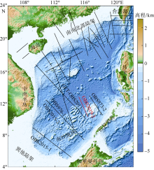
Fig. 1
The bathymetric map and main deep seismic survey lines in the South China Sea (modified from Qiu et al, 2012). Black lines show the locations of deep seismic survey lines. Red line indicates the OBS2019-2 survey line"

Fig. 1
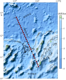
Fig. 2
The bathymetry map and location of OBS2019-2 in the Nansha Block. Red markers are the stations with successful data processing. Black points are the stations with abnormal data. White dots are the positions of lost instruments. The numbers in the figure indicate the OBS station number"

Fig. 2
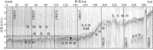
Fig. 3
Single-channel seismic profile along OBS2019-2 and its shallow geological interpretations. The vertical lines indicate the OBS positions on the profile"
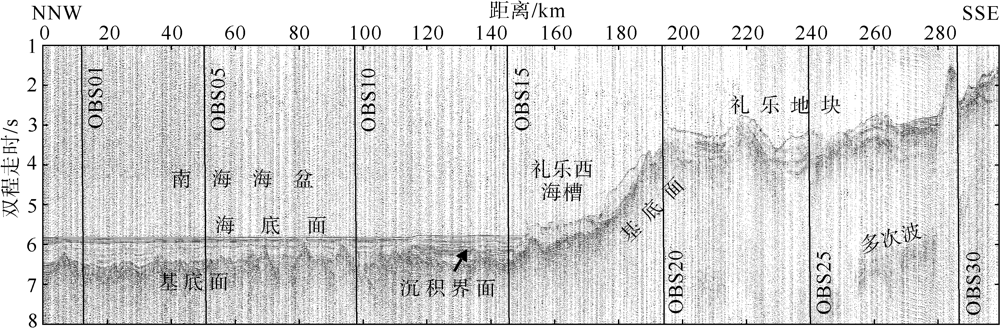
Fig. 3
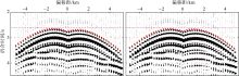
Fig. 4
Contrast of direct water phases (Pdw) before and after the relocation of OBS10. The reduced velocity is 6.0 km·s-1. The red points show the trave-times of direct water phases we picked and the purple dashed lines are used to judge the symmetry of direct water phases"
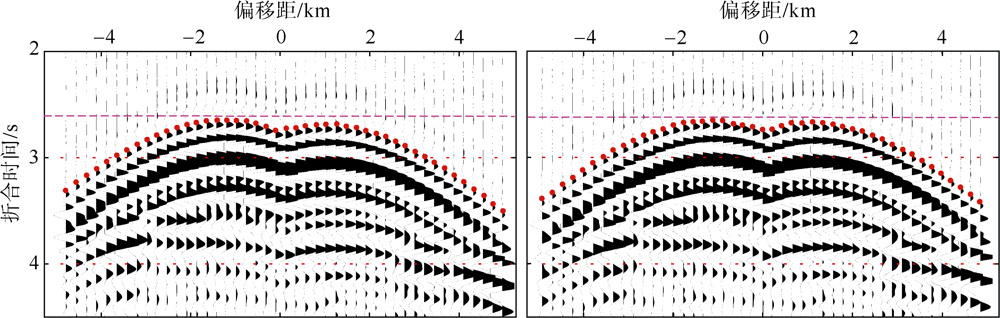
Fig. 4
Tab. 1
OBS relocation results of OBS2019-2"
| 站位 编号 | OBS 编号 | 投放点位置 | 校正后位置 | 校正后 水深/m | RMS/ms | t_adjust/s | ||
|---|---|---|---|---|---|---|---|---|
| 经度/E | 纬度/N | 经度/E | 纬度/N | |||||
| 01 | A37 | 115°05′35.48″ | 12°49′05.95″ | 115°05′40.02″ | 12°49′06.31″ | 4360 | 2.6 | -3.033 |
| 02 | L26 | 115°07′43.72″ | 12°44′24.97″ | 115°07′51.46″ | 12°44′28.46″ | 4361 | 1.3 | -0.144 |
| 03 | S11 | 115°09′51.84″ | 12°39′43.92″ | 115°09′46.73″ | 12°39′40.97″ | 4363 | 1.8 | -0.117 |
| 04 | L23 | 115°12′00.40″ | 12°35′03.62″ | 115°11′48.66″ | 12°34′58.58″ | 4358 | 3.4 | -0.124 |
| 05 | L85 | 115°14′07.84″ | 12°30′21.82″ | 115°14′09.71″ | 12°30′20.84″ | 4360 | 1.2 | -1.157 |
| 06 | B41 | 115°16′15.74″ | 12°25′40.76″ | 115°16′11.39″ | 12°25′40.58″ | 4357 | 1.4 | -0.011 |
| 07 | L54 | 115°18′23.54″ | 12°20′59.68″ | 115°18′19.80″ | 12°20′59.53″ | 4359 | 1.5 | -0.144 |
| 08 | L16 | 115°20′31.31″ | 12°16′18.55″ | 115°20′44.09″ | 12°16′24.71″ | 4357 | 1.9 | -0.126 |
| 09 | H56 | 115°22′38.96″ | 12°11′37.43″ | 115°22′24.17″ | 12°11′32.75″ | 4357 | 1.5 | -0.108 |
| 10 | L17 | 115°24′46.55″ | 12°06′56.30″ | 115°24′48.20″ | 12°07′00.08″ | 4359 | 1.9 | -0.130 |
| 11 | B29 | 115°26′54.06″ | 12°02′15.14″ | 115°26′31.38″ | 12°02′07.55″ | 4369 | 3.1 | -2.928 |
| 12 | L94 | 115°29′01.50″ | 11°57′33.95″ | 115°28′58.40″ | 11°57′33.95″ | 4326 | 0.7 | -1.115 |
| 13 | L96 | 115°31′08.87″ | 11°52′52.75″ | 115°31′09.48″ | 11°52′54.84″ | 4328 | 2.2 | -0.111 |
| 14 | L93 | 115°33′16.16″ | 11°48′11.56″ | 115°33′22.93″ | 11°48′14.18″ | 4321 | 1.7 | -0.122 |
| 15 | L35 | 115°35′23.39″ | 11°43′30.32″ | 115°35′12.37″ | 11°43′25.46″ | 4332 | 2.0 | -0.028 |
| 17 | B87 | 115°39′37.62″ | 11°34′07.86″ | 115°39′22.03″ | 11°34′00.05″ | 4070 | 2.3 | -0.027 |
| 18 | L70 | 115°41′45.31″ | 11°29′27.67″ | 115°41′31.38″ | 11°29′21.12″ | 3936 | 1.4 | -0.115 |
| 19 | L98 | 115°43′51.56″ | 11°24′45.29″ | 115°44′03.70″ | 11°24′49.57″ | 3104 | 3.3 | -0.076 |
| 20 | L95 | 115°45′58.43″ | 11°20′03.98″ | 115°45′38.92″ | 11°19′55.81″ | 2700 | 1.8 | -0.093 |
| 23 | B40 | 115°52′18.59″ | 11°05′60.00″ | 115°52′18.84″ | 11°06′00.07″ | 2142 | 4.2 | 0.039 |
| 24 | L31 | 115°54′25.20″ | 11°01′18.66″ | 115°53′52.12″ | 11°01′04.76″ | 2675 | 5.2 | -2.093 |
| 25 | L64 | 115°56′31.70″ | 10°56′37.28″ | 115°56′36.89″ | 10°56′40.06″ | 2350 | 5.5 | -0.099 |
| 27 | D28 | 116°00′44.57″ | 10°47′14.50″ | 116°00′43.31″ | 10°47′14.32″ | 2114 | 3.1 | -0.192 |
| 28 | L89 | 116°02′50.89″ | 12°49′05.95″ | 116°02′50.82″ | 10°42′33.16″ | 2228 | 3.5 | -1.893 |
| 29 | H52 | 116°04′57.14″ | 12°44′24.97″ | 116°04′43.25″ | 10°37′45.48″ | 2103 | 2.1 | 0.068 |
| 30 | L99 | 116°07′03.07″ | 12°39′43.92″ | 116°07′02.82″ | 10°33′09.86″ | 1794 | 3.9 | 0.054 |
Tab. 1
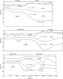
Fig. 5
The cross-section of crustal structure adjacent to the OBS2019-2. (a) The crustal structure profile of OBS973-2 (Ruan et al, 2011); (b) The crustal structure profile of OBS973-1 (Qiu et al, 2011); (c) The crustal structure profile of CFT-OBS2011 in the Nansha Block (Pichot et al, 2014)"
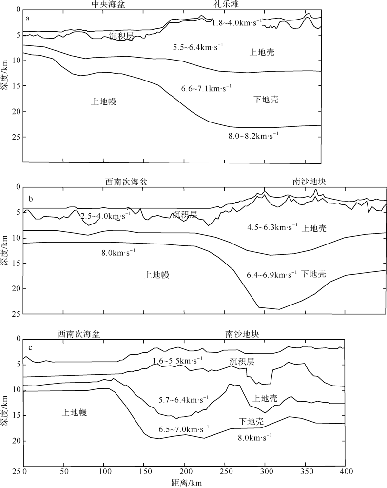
Fig. 5
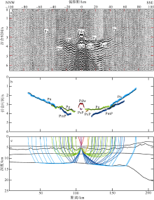
Fig. 6
Seismic phase identification and the travel-time ray tracing in the vertical component of seismic record of OBS11. (a) The seismic record profile and the seismic phase identification (the reduced velocity is 6.0 km·s-1); (b) Travel-time fitting (the black thin lines show the calculated travel-times and the thick colored lines show the picked travel-times); (c) The initial model of P-wave and ray-tracing of the seismic phases"

Fig. 6

Fig. 7
Vertical component of the seismic record in OBS14 and the seismic phase identification. (a) The seismic record profile and the seismic phase identification (the reduced velocity is 6.0 km·s-1); (b) Travel-time fitting (the black thin lines show the calculated travel-times and the thick colored lines show the picked travel-times); (c) The initial model of P-wave and ray-tracing of the seismic phases"
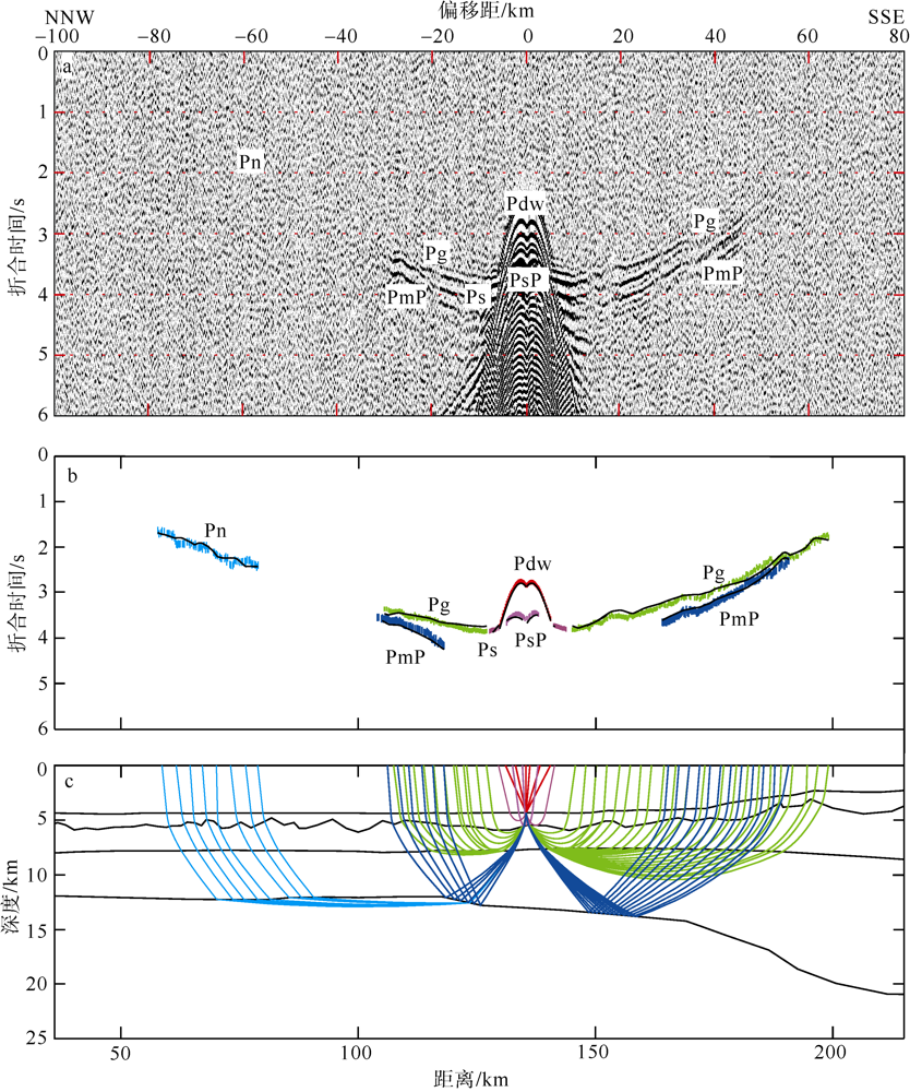
Fig. 7
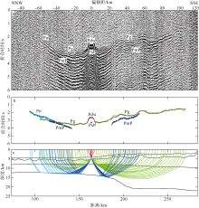
Fig. 8
Vertical component of the seismic record in OBS17 and the seismic phase identification. (a) The seismic record profile and the seismic phase identification (the reduced velocity is 6.0 km·s-1); (b) Travel-time fitting (the black thin lines show the calculated travel-times and the thick colored lines show the picked travel-times); (c) The initial model of P-wave and ray-tracing of the seismic phases"

Fig. 8

Fig. 9
Vertical component of the seismic record in OBS23 and the seismic phase identification. (a) The seismic record profile and the seismic phase identification (the reduced velocity is 6.0 km·s-1); (b) Travel-time fitting (the black thin lines show the calculated travel-times and the thick colored lines show the picked travel-times); (c) The initial model of P-wave and ray-tracing of the seismic phases"

Fig. 9
| [1] | 敖威, 赵明辉, 丘学林, 等, 2010. 西南印度洋中脊三维地震探测中炮点与海底地震仪的位置校正[J]. 地球物理学报, 53(12): 2982-2991. |
| AO WEI, ZHAO MINGHUI, QIU XUELIN, et al, 2010. The correction of shot and OBS position in the 3D seismic experiment of the SW Indian Ocean Ridge[J]. Chinese Journal of Geophysics, 53(12): 2982-2991. (in Chinese with English abstract) | |
| [2] | 丁巍伟, 李家彪, 黎明碧, 2011. 南海南部陆缘礼乐盆地新生代的构造-沉积特征及伸展机制: 来自NH973-2多道地震测线的证据[J]. 地球科学—中国地质大学学报, 36(5): 895-904. |
| DING WEIWEI, LI JIABIAO, LI MINGBI, 2011. Seismic stratigraphy, tectonic structure and extension model across the Reed Bank Basin in the south margin of South China Sea: evidence from NH973-2 multichannel seismic profile[J]. Earth Science — Journal of China University of Geosciences, 36(5): 895-904. (in Chinese with English abstract) | |
| [3] | 郭晓然, 赵明辉, 黄海波, 等, 2016. 西沙地块地壳结构及其构造属性[J]. 地球物理学报, 59(4): 1414-1425. |
| GUO XIAORAN, ZHAO MINGHUI, HUANG HAIBO, et al, 2016. Crustal structure of Xisha block and its tectonic attributes[J]. Chinese Journal of Geophysics, 59(4): 1414-1425. (in Chinese with English abstract) | |
| [4] | 郝天珧, 徐亚, 孙福利, 等, 2011. 南海共轭大陆边缘构造属性的综合地球物理研究[J]. 地球物理学报, 54(12): 3098-3116. |
| HAO TIANYAO, XU YA, SUN FULI, et al, 2011. Integrated geophysical research on the tectonic attribute of conjugate continental margin of South China Sea[J]. Chinese Journal of Geophysics, 54(12): 3098-3116. (in Chinese with English abstract) | |
| [5] | 黎雨晗, 黄海波, 丘学林, 等, 2020. 中沙海域的广角与多道地震探测[J]. 地球物理学报, 63(4): 1523-1537. |
| LI YUHAN, HUANG HAIBO, QIU XUELIN, et al, 2020. Wide-angle and multi-channel seismic surveys in Zhongsha waters[J]. Chinese Journal of Geophysics, 63(4): 1523-1537. (in Chinese with English abstract) | |
| [6] |
刘思青, 赵明辉, 张佳政, 等, 2017. 马尼拉海沟俯冲带前缘(21°N)海底地震仪数据处理初步成果[J]. 热带海洋学报, 36(2): 60-69.
doi: 10.11978/2016058 |
| LIU SIQING, ZHAO MINGHUI, ZHANG JIAZHENG, et al, 2017. OBS seismic data processing of the Manila Trench subduction zone (21°N) and some preliminary results[J]. Journal of Tropical Oceanography, 36(2): 60-69. (in Chinese with English abstract) | |
| [7] | 马飞, 黄海波, 丘学林, 等, 2021. 浅层结构不确定性对广角地震走时正演模拟结果的影响——以西沙地块OBS2011-1测线为例[J]. 地球物理学报, 64(10): 3669-3684. |
| MA FEI, HUANG HAIBO, QIU XUELIN, et al, 2021. Influence of shallow structure uncertainty on wide-angle seismic traveltime forward modeling — A case study using OBS2011-1 on the Xisha Block[J]. Chinese Journal of Geophysics, 64(10): 3669-3684. (in Chinese with English abstract) | |
| [8] | 牛雄伟, 卫小冬, 阮爱国, 等, 2014. 海底广角地震剖面反演方法对比——以南海礼乐滩OBS剖面为例[J]. 地球物理学报, 57(8): 2701-2712. |
| NIU XIONGWEI, WEI XIAODONG, RUAN AIGUO, et al, 2014. Comparision of inversion method of wide angle Ocean Bottom Seismometer profile: a case study of profile OBS973-2 across Liyue Bank in the South China Sea[J]. Chinese Journal of Geophysics, 57(8): 2701-2712. (in Chinese with English abstract) | |
| [9] | 丘学林, 陈颙, 朱日祥, 等, 2007. 大容量气枪震源在海陆联测中的应用: 南海北部试验结果分析[J]. 科学通报, 52(4): 463-469. |
|
QIU XUELIN, CHEN YONG, ZHU RIXIANG, et al, 2007. The application of large volume airgun sources to the onshore-offshore seismic surveys: implication of the experimental results in northern South China Sea[J]. Chinese Science Bulletin, 52(4): 553-560.. (in Chinese with English abstract)
doi: 10.1007/s11434-007-0051-1 |
|
| [10] | 丘学林, 赵明辉, 敖威, 等, 2011. 南海西南次海盆与南沙地块的OBS探测和地壳结构[J]. 地球物理学报, 54(12): 3117-3128. |
| QIU XUELIN, ZHAO MINGHUI, AO WEI, et al, 2011. OBS survey and crustal structure of the Southwest Sub-basin and Nansha Block, South China Sea[J]. Chinese Journal of Geophysics, 54(12): 3117-3128. (in Chinese with English abstract) | |
| [11] |
丘学林, 赵明辉, 徐辉龙, 等, 2012. 南海深地震探测的重要科学进程: 回顾和展望[J]. 热带海洋学报, 31(3): 1-9.
doi: 10.11978/j.issn.1009-5470.2012.03.001 |
| QIU XUELIN, ZHAO MINGHUI, XU HUILONG, et al, 2012. Important processes of deep seismic surveys in the South China Sea: retrospection and expectation[J]. Journal of Tropical Oceanography, 31(3): 1-9. (in Chinese with English abstract) | |
| [12] | 阮爱国, 牛雄伟, 丘学林, 等, 2011. 穿越南沙礼乐滩的海底地震仪广角地震试验[J]. 地球物理学报, 54(12): 3139-3149. |
| RUAN AIGUO, NIU XIONGWEI, QIU XUELIN, et al, 2011. A wide angle ocean bottom seismometer profile across Liyue Bank, the southern margin of South China Sea[J]. Chinese Journal of Geophysics, 54(12): 3139-3149. (in Chinese with English abstract) | |
| [13] |
汪俊, 邱燕, 阎贫, 等, 2019. 跨南海西南次海盆OBS、多道地震与重力联合调查[J]. 热带海洋学报, 38(4): 81-90.
doi: 10.11978/2018108 |
|
WANG JUN, QIU YAN, YAN PIN, et al, 2019. A joint investigation using OBS, multi-channel seismic and gravity data across the Southwestern Sub-basin of the South China Sea[J]. Journal of Tropical Oceanography, 38(4): 81-90. (in Chinese with English abstract)
doi: 10.11978/2018108 |
|
| [14] |
汪品先, 2009. 南海——我国深海研究的突破口[J]. 热带海洋学报, 28(3): 1-4.
doi: 10.11978/j.issn.1009-5470.2009.03.001 |
| WANG PINXIAN, 2009. Toward scientific breakthrough in the South China Sea[J]. Journal of Tropical Oceanography, 28(3): 1-4. (in Chinese with English abstract) | |
| [15] | 王强, 丘学林, 赵明辉, 等, 2016. 南海海底地震仪异常数据的分析和处理[J]. 地球物理学报, 59(3): 1102-1112. |
| WANG QIANG, QIU XUELIN, ZHAO MINGHUI, et al, 2016. Analysis and processing on abnormal OBS data in the South China Sea[J]. Chinese Journal of Geophysics, 59(3): 1102-1112. (in Chinese with English abstract) | |
| [16] | 王强, 赵明辉, 张浩宇, 等, 2020. 基于重处理数据的南海西北次海盆地壳速度结构[J]. 中国科学: 地球科学, 50(11): 1553-1568. |
|
WAGN QIANG, ZHAO MINGHUI, ZHANG HAOYU, et al, 2020. Crustal velocity structure of the Northwest Sub-basin of the South China Sea based on seismic data reprocessing[J]. Science China: Earth Sciences, 63(11): 1791-1806.. (in Chinese with English abstract)
doi: 10.1007/s11430-020-9654-4 |
|
| [17] | 杨富东, 张佳政, 杜峰, 等, 2020. 三维OBS探测实验中炮点和OBS位置校正新方法[J]. 地球物理学报, 63(2): 766-777. |
| YANG FUDONG, ZHANG JIAZHENG, DU FENG, et al, 2020. A-new method for shots and OBSs’ relocation applying in three-dimensional seismic survey[J]. Chinese Journal of Geophysics, 63(2): 766-777. (in Chinese with English abstract) | |
| [18] | 姚伯初, 1996. 南海海盆新生代的构造演化史[J]. 海洋地质与第四纪地质, 16(2): 1-13. |
| YAO BOCHU, 1996. Tectonic evolution of the South China Sea in Cenozoic[J]. Marine Geology & Quaternary Geology, 16(2): 1-13. (in Chinese with English abstract) | |
| [19] | 张浩宇, 丘学林, 张佳政, 等, 2019. 国产海底地震仪的时间记录与原始数据精细校正[J]. 地球物理学报, 62(1): 172-182. |
| ZHANG HAOYU, QIU XUELIN, ZHANG JIAZHENG, et al, 2019. Time record and accurate correction of Chinese OBS raw data[J]. Chinese Journal of Geophysics, 62(1): 172-182. (in Chinese with English abstract) | |
| [20] | 张佳政, 丘学林, 赵明辉, 等, 2018. 南海巴士海峡三维OBS探测的异常数据恢复[J]. 地球物理学报, 61(4): 1529-1538. |
| ZHANG JIAZHENG, QIU XUELIN, ZHAO MINGHUI, et al, 2018. Abnormal data retrieval of three-dimensional OBS survey at the Bashi Channel area of the South China Sea[J]. Chinese Journal of Geophysics, 61(4): 1529-1538. (in Chinese with English abstract) | |
| [21] | 张莉, 赵明辉, 王建, 等, 2013. 南海中央次海盆OBS位置校正及三维地震探测新进展[J]. 地球科学—中国地质大学学报, 38(1): 33-42. |
|
ZAHNG LI, ZAHO MINGHUI, WANG JIAN, et al, 2013. Correction of OBS position and recent advances of 3D seismic exploration in the Central Sub-basin of South China Sea[J]. Earth Science — Journal of China University of Geosciences, 38(1): 33-42. (in Chinese with English abstract)
doi: 10.3799/dqkx.2013.004 |
|
| [22] | 赵明辉, 丘学林, 夏戡原, 等, 2004. 南海东北部海陆联测地震数据处理及初步结果[J]. 热带海洋学报, 23(1): 58-63. |
| ZHAO MINGHUI, QIU XUELIN, XIA KANYUAN, et al, 2004. Onshore-offshore seismic data processing and preliminary results in NE South China Sea[J]. Journal of Tropical Oceanography, 23(1): 58-63. (in Chinese with English abstract) | |
| [23] | 赵明辉, 丘学林, 夏少红, 等, 2008. 大容量气枪震源及其波形特征[J]. 地球物理学报, 51(2): 558-565. |
|
ZHAO MINGHUI, QIU XUELIN, XIA SHAOHONG, et al, 2008. Large volume air-gun sources and its seismic waveform characters[J]. Chinese Journal of Geophysics, 51(2): 558-565. (in Chinese with English abstract)
doi: 10.1002/cjg2.1246 |
|
| [24] | BRIAIS A, PATRIAT P, TAPPONNIER P, 1993. Updated interpretation of magnetic anomalies and seafloor spreading stages in the South China Sea: implications for the Tertiary tectonics of Southeast Asia[J]. Journal of Geophysical Research: Solid Earth, 98(B4): 6299-6328. |
| [25] |
DU FENG, ZHANG JIAZHENG, YANG FUDONG, et al, 2018. Combination of least square and monte carlo methods for OBS relocation in 3D seismic survey near Bashi Channel[J]. Marine Geodesy, 41(5): 494-515.
doi: 10.1080/01490419.2018.1479993 |
| [26] |
FULLER M, ALI J R, MOSS S J, et al, 1999. Paleomagnetism of Borneo[J]. Journal of Asian Earth Sciences, 17(1-2): 3-24.
doi: 10.1016/S0743-9547(98)00057-9 |
| [27] |
HOU WENAI, LI CHUNFENG, WAN XIAOLI, et al, 2019. Crustal S-wave velocity structure across the northeastern South China Sea continental margin: implications for lithology and mantle exhumation[J]. Earth and Planetary Physics, 3(4): 314-329.
doi: 10.26464/epp2019033 |
| [28] |
HUANG HAIBO, QIU XUELIN, PICHOT T, et al, 2019. Seismic structure of the northwestern margin of the South China Sea: implication for asymmetric continental extension[J]. Geophysical Journal International, 218(2): 1246-1261.
doi: 10.1093/gji/ggz219 |
| [29] |
LI YUHAN, HUANG HAIBO, GREVEMEYER I, et al, 2021. Crustal structure beneath the Zhongsha Block and the adjacent abyssal basins, South China Sea: new insights into rifting and initiation of seafloor spreading[J]. Gondwana Research, 99: 53-76.
doi: 10.1016/j.gr.2021.06.015 |
| [30] | LIU SIQING, ZHAO MINGHUI, SIBUET J C, et al, 2018. Geophysical constraints on the lithospheric structure in the northeastern South China Sea and its implications for the South China Sea geodynamics[J]. Tectonophysics, 742-743: 101-119. |
| [31] |
LIU YUTAO, LI CHUNFENG, WEN YONGLIN, et al, 2021. Mantle serpentinization beneath a failed rift and post- spreading magmatism in the northeastern South China Sea margin[J]. Geophysical Journal International, 225(2): 811-828.
doi: 10.1093/gji/ggab006 |
| [32] |
MJELDE R, RAUM T, MURAI Y, et al, 2007. Continent - ocean-transitions: review, and a new tectono-magmatic model of the Vøring Plateau, NE Atlantic[J]. Journal of Geodynamics, 43(3): 374-392.
doi: 10.1016/j.jog.2006.09.013 |
| [33] |
PICHOT T, DELESCLUSE M, CHAMOT-ROOKE N, et al, 2014. Deep crustal structure of the conjugate margins of the SW South China Sea from wide-angle refraction seismic data[J]. Marine and Petroleum Geology, 58: 627-643.
doi: 10.1016/j.marpetgeo.2013.10.008 |
| [34] | RU K, PIGOTT J D, 1986. Episodic rifting and subsidence in the South China Sea[J]. AAPG Bulletin, 70(9): 1136-1155. |
| [35] |
SUN ZHEN, ZHONG ZHIHONG, KEEP M, et al, 2009. 3D analogue modeling of the South China Sea: a discussion on breakup pattern[J]. Journal of Asian Earth Sciences, 34(4): 544-556.
doi: 10.1016/j.jseaes.2008.09.002 |
| [36] | TAYLOR B, HAYES D E, 1980. The tectonic evolution of the South China Basin[M]//HAYES D E. The tectonic and geologic evolution of Southeast Asian Seas and Islands. Washington: American Geophysical Union: 89-104. |
| [37] | TAYLOR B, HAYES D E, 1983. Origin and history of the South China Sea basin[M]//HAYES D E. The tectonic and geologic evolution of Southeast Asian Seas and Islands: part 2. Washington: American Geophysical Union:23-56. |
| [38] |
WAN KUIYUAN, XIA SHAOHONG, CAO JINGHE, et al, 2017. Deep seismic structure of the northeastern South China Sea: origin of a high-velocity layer in the lower crust[J]. Journal of Geophysical Research: Solid Earth, 122(4): 2831-2858.
doi: 10.1002/2016JB013481 |
| [39] |
WAN XIAOLI, LI CHUNFENG, ZHAO MINGHUI, et al, 2019. Seismic velocity structure of the magnetic quiet zone and continent - ocean boundary in the northeastern South China Sea[J]. Journal of Geophysical Research: Solid Earth, 124(11): 11866-11899.
doi: 10.1029/2019JB017785 |
| [40] |
WEI XIAODONG, RUAN AIGUO, DING WEIWEI, et al, 2020. Crustal structure and variation in the southwest continental margin of the South China Sea: evidence from a wide-angle seismic profile[J]. Journal of Asian Earth Sciences, 203: 104557.
doi: 10.1016/j.jseaes.2020.104557 |
| [41] |
WHITMARSH R B, MANATSCHAL G, MINSHULL T A, 2001. Evolution of magma-poor continental margins from rifting to seafloor spreading[J]. Nature, 413(6852): 150-154.
doi: 10.1038/35093085 |
| [42] |
ZHAO MINGHUI, QIU XUELIN, XIA SHAOHONG, et al, 2010. Seismic structure in the northeastern South China Sea: S-wave velocity and Vp/Vs ratios derived from three-component OBS data[J]. Tectonophysics, 480(1-4): 183-197.
doi: 10.1016/j.tecto.2009.10.004 |
| [1] | GUO Xiaoran, LIU Shanhu. Characteristics of secondary Ps phases recorded by ocean bottom seismometer in the Taiwan Strait and its application [J]. Journal of Tropical Oceanography, 2022, 41(5): 57-63. |
| [2] | ZHANG Haoyu, QIU Xuelin, HUANG Haibo. Automatic search and non-uniqueness analysis of shear wave models from active Ocean Bottom Seismometer data [J]. Journal of Tropical Oceanography, 2022, 41(1): 194-203. |
| [3] | SU Xiaokang, ZHAO Minghui, LI Zizheng, YUAN Ye, WANG Xingyue, CHENG Jinhui, ZHANG Jiazheng. Preliminary results of the crustal structure along OBS2018-H2 in the northern continental margin of the South China Sea* [J]. Journal of Tropical Oceanography, 2021, 40(5): 111-122. |
| [4] | REN Ziqiang, SHI Xiaobin, WANG Xiaofang, ZHAO Peng, SHEN Yongqiang. Deep thermal state in the Nansha Trough of South China Sea and its tectonic implications [J]. Journal of Tropical Oceanography, 2021, 40(4): 98-109. |
| [5] | Tao XING, Wenhuan ZHAN, Fuyuan LI, Xi CHEN. Single-source, single-cable, long-array, seismic data processing in complex sea conditions of Dongsha sea area [J]. Journal of Tropical Oceanography, 2020, 39(4): 91-99. |
| [6] | Zhen JIN, Xiaoran GUO, Fangying CHEN. Correction of made-in-China OBS raw data based on 2019 Fujian and Taiwan Straits crustal structures in sea-land exploration experiments [J]. Journal of Tropical Oceanography, 2020, 39(3): 42-48. |
| [7] | YANG Bifeng, XIONG Cheng, CAO Jinghe, SUN Jinlong, WAN Kuiyuan, XIA Shaohong. Constrains of sliding wave phases on the low-velocity layer in the Pearl River Estuary [J]. Journal of Tropical Oceanography, 2020, 39(1): 106-119. |
| [8] | Qiang WANG, Minghui ZHAO, Jiazheng ZHANG, Longtao SUN, Xuelin QIU. Analysis and tests on an OBS layout for deep seismic survey in the IODP legs 367-368 area of the South China Sea [J]. Journal of Tropical Oceanography, 2018, 37(1): 90-97. |
| [9] | Jian WANG, Minghui ZHAO, Jiazheng ZHANG, Enyuan HE, Xuelin QIU. The importance of seafloor topographic correction in identifying and picking seismic phases of OBS [J]. Journal of Tropical Oceanography, 2017, 36(5): 93-100. |
| [10] | Fenghua ZHOU, Rongwang ZHANG, Rui SHI, Yunkai HE, Ju CHEN, Dongxiao WANG, Qiang XIE. A study of data processing and quality assessment of the eddy convariance system off Yongxing Island [J]. Journal of Tropical Oceanography, 2017, 36(4): 48-59. |
| [11] | Siqing LIU, Minghui ZHAO, Jiazheng ZHANG, Longtao SUN, Ya XU, Wenhuan ZHAN, Xuelin QIU. OBS seismic data processing of the Manila Trench subduction zone (21°N) and some preliminary results [J]. Journal of Tropical Oceanography, 2017, 36(2): 60-69. |
| [12] | ZHANG Li, ZHAO Minghui, QIU Xuelin, WANG Qiang. Recent progress of converted shear-wave phase identification in Nansha Block using Ocean Bottom Seismometers data [J]. Journal of Tropical Oceanography, 2016, 35(1): 61-71. |
| [13] | QI Jiang-hao, ZHANG Xun-hua, WU Zhi-qiang, QIU Xue-lin, ZHAO Ming-hui, XIA Shao-hong, GUO Xing-wei, HAO Tian-yao, ZHENG Yan-peng, FANG Nian-qiao. Preliminary results of the South Yellow Sea OBS 2013 onshore-offshore joint deep seismic survey [J]. Journal of Tropical Oceanography, 2015, 34(2): 76-84. |
| [14] | ZHANG Jia-zheng, ZHAO Ming-hui, QIU Xue-lin, RUAN Ai-guo, LI Jia-biao, CHEN Yong-shun, AO Wei, WEI Xiao-dong. OBS seismic data processing and preliminary results on the hydrothermal field of the Southwest Indian Ridge [J]. Journal of Tropical Oceanography, 2012, 31(3): 79-89. |
| [15] | CAO Jing-he, XIA Shao-hong, SUN Jin-long, ZHU Jun-jiang, XU Hui-long. Preliminary results of onshore-offshore seismic experiments in a potential strong earthquake area off the Pearl River Estuary [J]. Journal of Tropical Oceanography, 2012, 31(3): 71-78. |
|
||