
Journal of Tropical Oceanography ›› 2023, Vol. 42 ›› Issue (6): 52-62.doi: 10.11978/2023009CSTR: 32234.14.2023009
• Marine Hydrology • Previous Articles Next Articles
Comparative study on different tide level correction methods in remote sensing extraction of coastline under balanced profile model*
WU Tongren1,2( ), LIU Pei2,3(), YU Jitao2,3, WEN Tingting1,2
- 1. Henan Polytechnic University, Jiaozuo 454003, China
2. Hainan Academy of Ocean and Fisheries Sciences, Haikou 571126, China
3. Yazhou Bay Innovation Institute, Hainan Tropical Ocean University, Sanya 572025, China
-
Received:2023-01-24Revised:2023-03-23Online:2023-11-10Published:2023-04-07 -
Supported by:National Natural Science Foundation of China(42071007); The Open project program of Yazhou Bay Innovation Research Institute of Hainan Tropical Ocean University(2022CXYKFKT03); Hainan Provincial Natural Science Foundation of China(423MS120); Foundation of Hainan Academy of Ocean and Fisheries Sciences(KYL-2023-01)
Cite this article
WU Tongren, LIU Pei, YU Jitao, WEN Tingting. Comparative study on different tide level correction methods in remote sensing extraction of coastline under balanced profile model*[J].Journal of Tropical Oceanography, 2023, 42(6): 52-62.
share this article
Add to citation manager EndNote|Reference Manager|ProCite|BibTeX|RefWorks

Fig. 1
Geomorphology of study area. (a) Haimen Bay; (b) Pinghai Bay"

Fig. 1

Fig. 2
Flow chart"

Fig. 2

Fig. 3
Traditional linear tide level correction model"
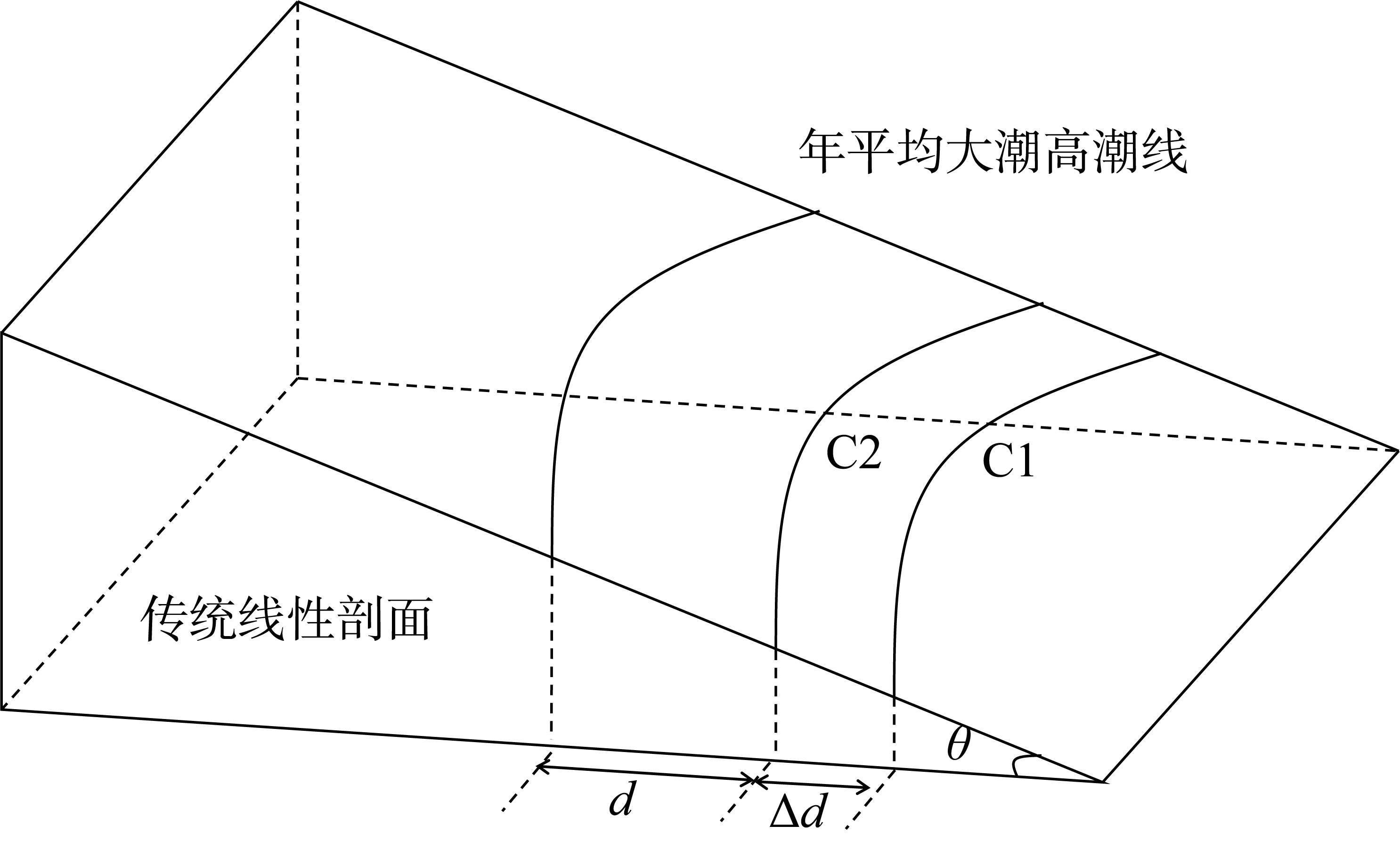
Fig. 3

Fig. 4
Linear fitting tidal correction model"
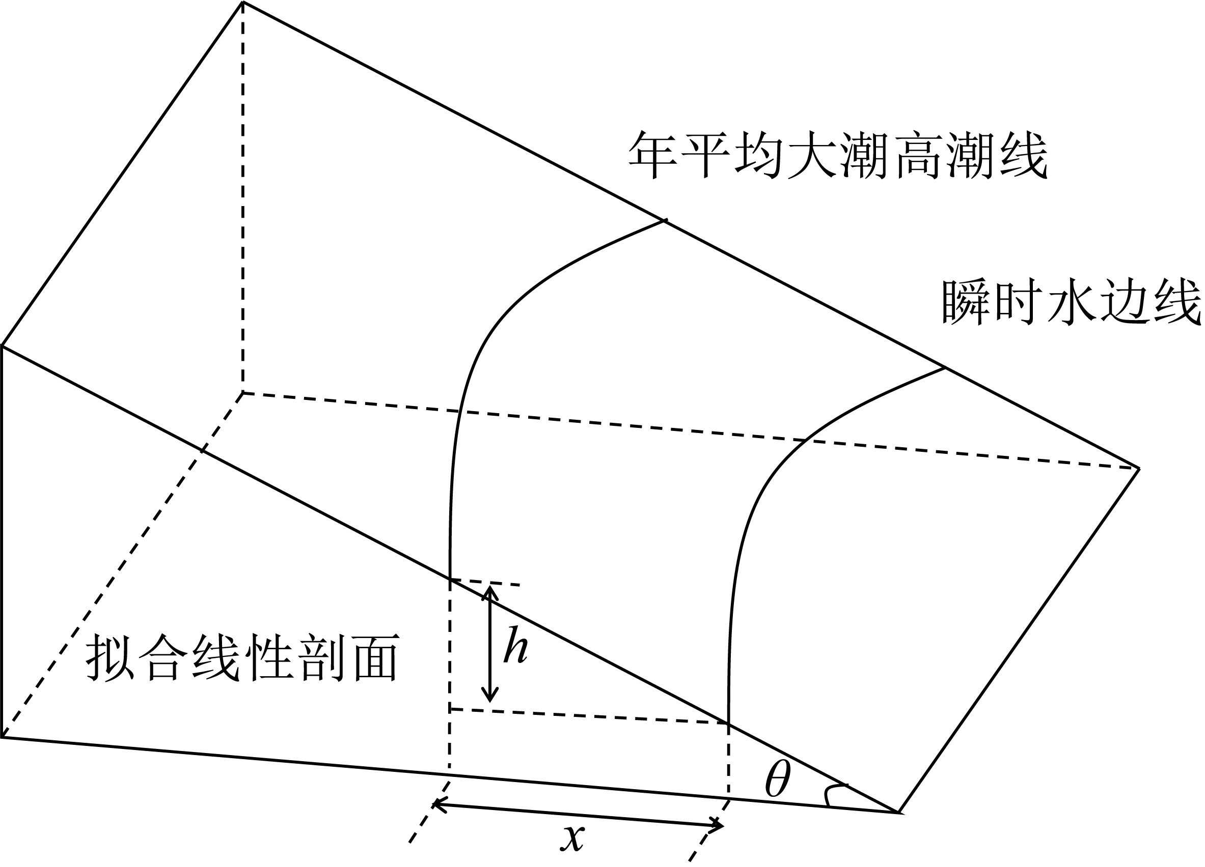
Fig. 4

Fig. 5
Fitting tide level correction model of balanced profile"

Fig. 5

Fig. 6
Water boundary line extraction in Haimen Bay"

Fig. 6

Fig. 7
Water boundary line extraction in Pinghai Bay"
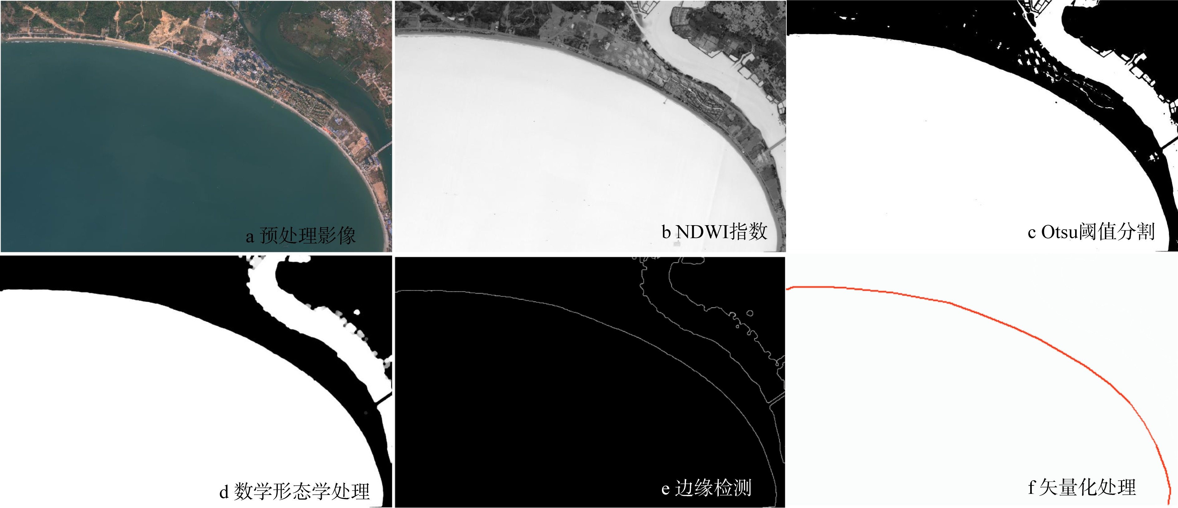
Fig. 7

Fig. 8
Figure a and figure b respectively show the monthly average high tide data of Haimen Bay (a) and Pinghai Bay (b) in 2017"

Fig. 8

Fig. 9
Linear fitting results of Pinghai Bay (a) and Haimen Bay (b)"

Fig. 9

Fig. 10
Fitting results based on balanced profile model"

Fig. 10
Tab. 1
Evaluation metric for fitting model"
| 地区 | 拟合模型 | 确定系数 | 相关系数 | 误差平方和 |
|---|---|---|---|---|
| 海门湾 | Bodge剖面模型 | 0.95 | 0.98 | 3.95 |
| 海门湾 | Bruun-Dean剖面模型 | 0.90 | 0.97 | 8.05 |
| 海门湾 | 线性拟合模型 | 0.43 | 0.92 | 45.16 |
| 平海湾 | Bodge剖面模型 | 0.93 | 0.87 | 3.02 |
| 平海湾 | Bruun-Dean剖面模型 | 0.92 | 0.80 | 4.72 |
| 平海湾 | 线性拟合模型 | 0.90 | 0.71 | 9.76 |
Tab. 1
Tab. 2
Accuracy assessment"
| 潮位校正方法 | 最大偏移量/m | 最小偏移量/m | 平均偏移量/m | 标准差/m |
|---|---|---|---|---|
| Bodge模型潮位校正 | 6.7 | 0.1 | 2.0 | 1.2 |
| Bruun-Dean模型潮位校正 | 8.2 | 0 | 2.6 | 1.8 |
| 线性模型潮位校正 | 9.6 | 2.6 | 3.9 | 2.1 |
| 传统潮位校正 | 8.9 | 1.0 | 3.1 | 2.0 |
Tab. 2

Fig. 11
Statistical of coastline of Haimen bay coastline section offset under Bodge tide correction"
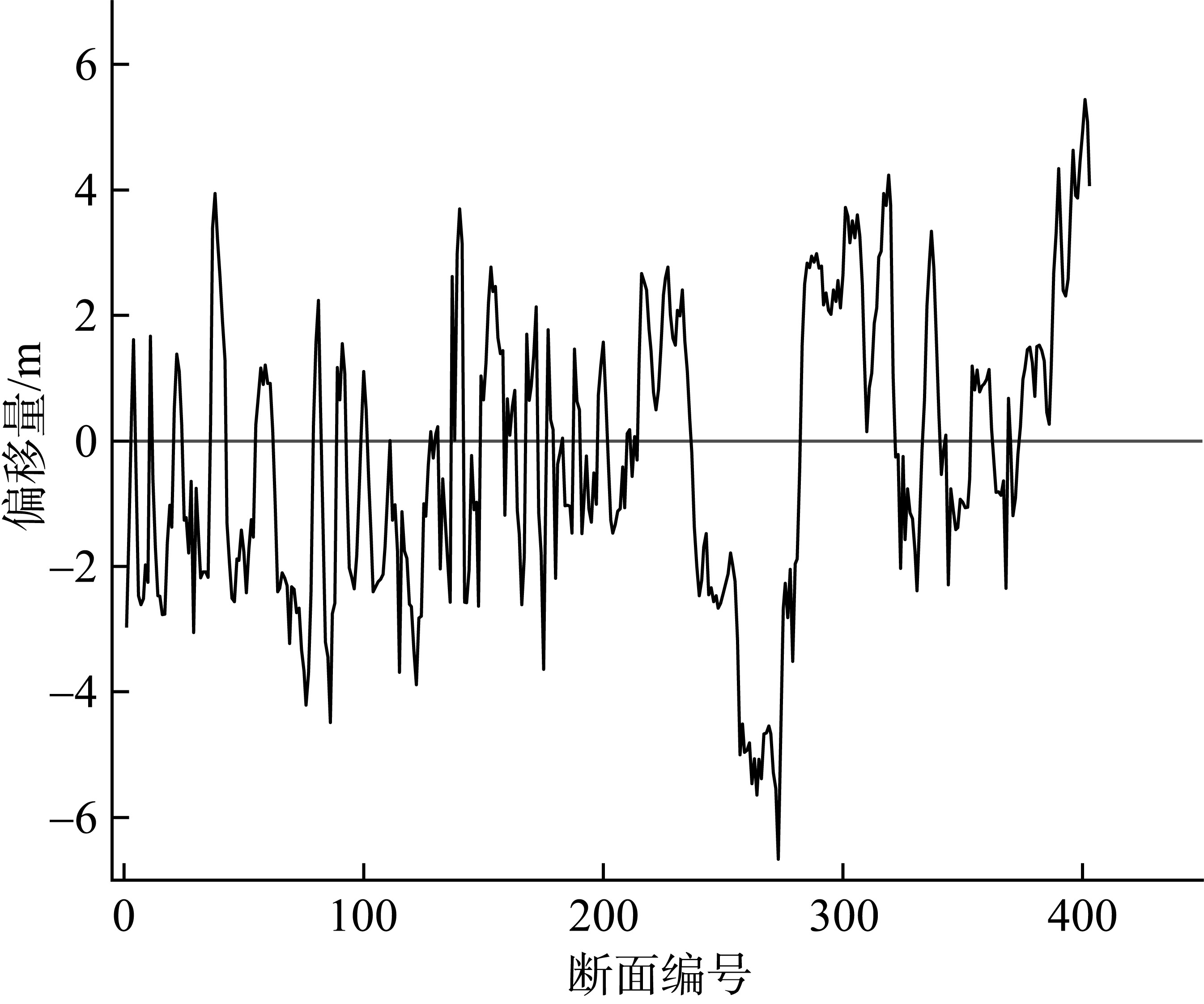
Fig. 11
| [1] |
陈玮彤, 张东, 施顺杰, 等, 2017. 江苏中部淤泥质海岸岸线变化遥感监测研究[J]. 海洋学报, 39(5): 138-148.
|
|
|
|
| [2] |
陈子燊, 1997. 海滩剖面形态与地形动态研究的进展[J]. 海洋通报, (1): 86-91.
|
|
|
|
| [3] |
贾明明, 刘殿伟, 王宗明, 等, 2013. 面向对象方法和多源遥感数据的杭州湾海岸线提取分析[J]. 地球信息科学学报, 15(2): 262-269.
doi: 10.3724/SP.J.1047.2013.00262 |
|
doi: 10.3724/SP.J.1047.2013.001262 |
|
| [4] |
李志强, 陈子燊, 2002. 海滩平衡剖面形态研究进展[J]. 海洋通报, (5): 82-89.
|
|
|
|
| [5] |
李志强, 陈子燊, 2009. 海滩平衡剖面模型中参数意义及相互关系探讨[J]. 海洋工程, 27(4): 108-115.
|
|
|
|
| [6] |
林松, 俞晓牮, 庄小冰, 等, 2020. 厦门岛海岸线分形特性演变规律的研究[J]. 海洋科学进展, 38(1): 121-129.
|
|
|
|
| [7] |
刘百桥, 孟伟庆, 赵建华, 等, 2015. 中国大陆1990—2013年海岸线资源开发利用特征变化[J]. 自然资源学报, 30(12): 2033-2044.
|
|
|
|
| [8] |
刘善伟, 张杰, 马毅, 等, 2011. 遥感与DEM相结合的海岸线高精度提取方法[J]. 遥感技术与应用, 26(5): 613-618.
|
|
|
|
| [9] |
马小峰, 赵冬至, 张丰收, 等, 2007. 海岸线卫星遥感提取方法研究进展[J]. 遥感技术与应用, 22(4): 575-580.
|
|
|
|
| [10] |
邱志伟, 刘晓霞, 章铭诚, 2021. 基于星载SAR影像的苏北地区海岸线提取研究[J]. 地理空间信息, 19(1): 4-7, 141.
|
|
|
|
| [11] |
沈琦, 汪承义, 赵斌, 2012. 几何活动轮廓模型用于高分辨率遥感影像海岸线自动提取[J]. 复旦学报(自然科学版), 51(1): 77-82, 104.
|
|
|
|
| [12] |
盛辉, 张驰, 万剑华, 2021. 基于多时相遥感数据的海岸线自动提取方法[J]. 海洋科学, 45(5): 16-22.
|
|
|
|
| [13] |
孙孟昊, 蔡玉林, 顾晓鹤, 等, 2019. 基于潮汐规律修正的海岸线遥感监测[J]. 遥感信息, 34(6): 105-112.
|
|
|
|
| [14] |
王常颖, 王志锐, 初佳兰, 等, 2017. 基于决策树与密度聚类的高分辨率影像海岸线提取方法[J]. 海洋环境科学, 36(4): 590-595.
|
|
|
|
| [15] |
王靖雯, 牛振国, 2017. 基于潮位校正的盐城滨海潮间带遥感监测及变化分析[J]. 海洋学报, 39(5): 149-160.
|
|
|
|
| [16] |
毋亭, 侯西勇, 2016. 海岸线变化研究综述[J]. 生态学报, 36(4): 1170-1182.
|
|
|
|
| [17] |
吴一全, 刘忠林, 2019. 遥感影像的海岸线自动提取方法研究进展[J]. 遥感学报, 23(4): 582-602.
|
|
|
|
| [18] |
徐涵秋, 2005. 利用改进的归一化差异水体指数(MNDWI)提取水体信息的研究[J]. 遥感学报, (5): 589-595.
|
|
|
|
| [19] |
尹航, 戚洪帅, 蔡锋, 等, 2022. 高分影像砂质海岸线精细提取及校正方法[J]. 海洋学报, 44(4): 143-152.
|
|
|
|
| [20] |
袁欣智, 江洪, 陈芸芝, 等, 2016. 一种应用大津法的自适应阈值水体提取方法[J]. 遥感信息, 31(5): 36-42.
|
|
|
|
| [21] |
张锦, 赖祖龙, 孙杰, 2020. Otsu法、区域生长法及形态学相结合的遥感图像海岸线提取[J]. 测绘通报, (10): 89-92.
doi: 10.13474/j.cnki.11-2246.2020.0325 |
|
doi: 10.13474/j.cnki.11-2246.2020.0325 |
|
| [22] |
张翔, 王霄鹏, 黄安齐, 等, 2021. 基于遥感影像提取山东半岛复杂海岸线及海岸线多年变迁研究[J]. 海洋湖沼通报, 43(2): 171-181.
|
|
|
|
| [23] |
张旭凯, 张霞, 杨邦会, 等, 2013. 结合海岸类型和潮位校正的海岸线遥感提取[J]. 国土资源遥感, 25(4): 91-97.
|
|
|
|
| [24] |
郑修诚, 周斌, 雷惠, 等, 2022. 基于GEE的杭州湾慈溪段潮滩提取及时空变化分析[J]. 自然资源遥感, 34(1): 18-26.
|
|
|
|
| [25] |
朱长明, 张新, 骆剑承, 等, 2013. 基于样本自动选择与SVM结合的海岸线遥感自动提取[J]. 国土资源遥感, 25(2): 69-74.
|
|
|
|
| [26] |
朱萝云, 刘婷婷, 凡仁福, 等, 2022. 1986-2019年粤东企望湾砂质海岸线演变过程与驱动机制研究[J]. 海洋学报, 44(7): 20-32.
|
|
|
|
| [27] |
|
| [28] |
doi: 10.3390/su10020477 |
| [29] |
doi: 10.1080/0143116031000139890 |
| [30] |
doi: 10.1117/1.OE.53.1.013107 |
| [31] |
doi: 10.3390/w14060855 |
| [32] |
doi: 10.1016/j.coastaleng.2019.04.004 |
| [33] |
doi: 10.1007/s13344-016-0041-7 |
| [34] |
doi: 10.3390/jmse10040541 |
| No related articles found! |
|
||