
Journal of Tropical Oceanography ›› 2024, Vol. 43 ›› Issue (6): 50-62.doi: 10.11978/2024022CSTR: 32234.14.2024022
• Marine Meteorology • Previous Articles Next Articles
Diagnostic analysis of a cold vortex persistent rainstorm process along the coast of Shandong Peninsula in early summer
CHU Zihe1( ), MEI Chanjuan2,3(), ZHANG Can3, WAN Fujing4, XIN Wenpeng3
- 1. College of Ocean and Meteorology, Guangdong Ocean University, Zhanjiang 524003, China
2. Key Laboratory for Meteorological Disaster Prevention and Mitigation of Shandong, Jinan 250031, China
3. Weihai Meteorological Bureau of Shandong Province, Weihai 264200, China
4. Qingdao Meteorological Bureau of Shandong Province, Qingdao 266000, China
-
Received:2024-01-18Revised:2024-04-10Online:2024-11-10Published:2024-12-05 -
Contact:MEI Chanjuan -
Supported by:Natural Science Foundation of Shandong Province(ZR2021MD010); Innovation Fund Project of the Public Service Center of China Meteorological Administration(M2021019); Innovative Team of Typhoon and Marine Meteorology of Shandong Province(SDCXTD2021-2); Key Scientific Research Project of Shandong Provincial Meteorological Bureau(2022sdqxz11); Scientific and Technological Research Project of Shandong Provincial Meteorological Bureau(2022sdqxm12)
CLC Number:
- P458.121.1
Cite this article
CHU Zihe, MEI Chanjuan, ZHANG Can, WAN Fujing, XIN Wenpeng. Diagnostic analysis of a cold vortex persistent rainstorm process along the coast of Shandong Peninsula in early summer[J].Journal of Tropical Oceanography, 2024, 43(6): 50-62.
share this article
Add to citation manager EndNote|Reference Manager|ProCite|BibTeX|RefWorks
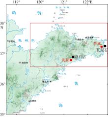
Fig. 1
Topographic map of the eastern Shandong and the study area (the area enclosed by the red line)"
Fig. 1
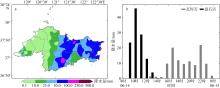
Fig. 2
Cumulative precipitation distribution in Weihai and Yantai from 08:00 CST on June 14 to 08: 00 CST on June 15, 2022 (a)and hourly rainfall evolution at Panshidian and Wawushishi stations from 08:00 CST on June 14 to 01: 00 CST on June 15 (b)"

Fig. 2
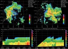
Fig. 3
Combined radar reflectivity factor (a, b) and reflectivity factor vertical profiles (c, d) for June 14, 2022 at 08: 29 CST, 19: 57 CST"

Fig. 3
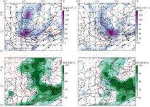
Fig. 4
High-altitude situation at 500hPa 08: 00 CST (a, b) and 850hPa 20: 00 CST (c, d) on June 14, 2022"
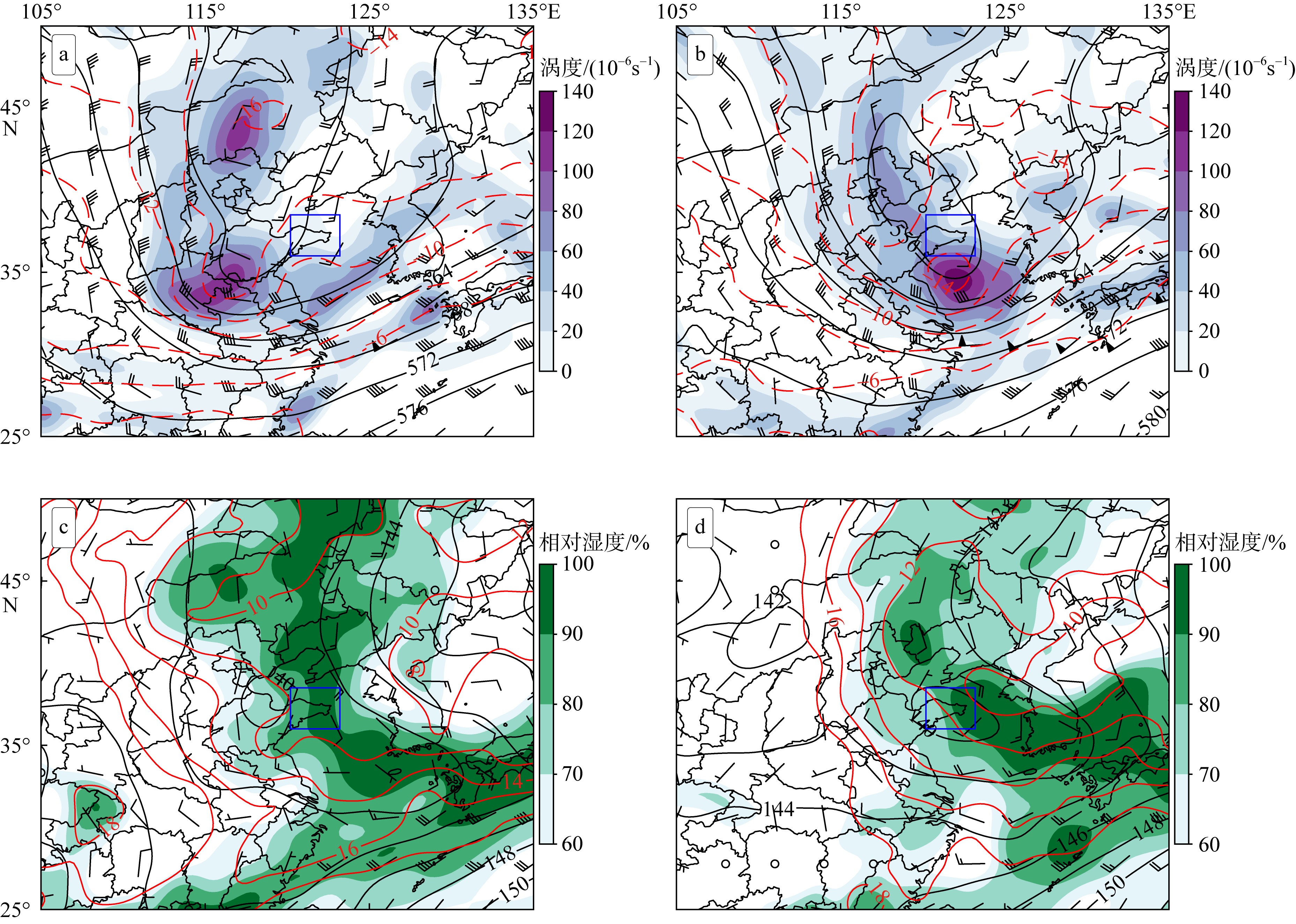
Fig. 4
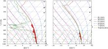
Fig. 5
Sounding curves of Rongcheng sounding station at 08: 00 CST (a) and 20: 00 CST (b) on June 22, 2022"

Fig. 5
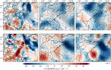
Fig. 6
Water vapor flux, water vapor flux divergence and wind field at 08:00 CST(a-c) and 20:00 CST(d-f) on June 14, 2022"

Fig. 6
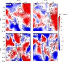
Fig. 7
Hovmöller diagram of the zonal pseudo-equivalent temperature and temperature advection on June 14, 2022"

Fig. 7
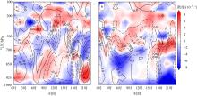
Fig. 8
Vertical velocity and dispersion over time in Haiyang (a) and Rongcheng (b) on June 14, 2022"
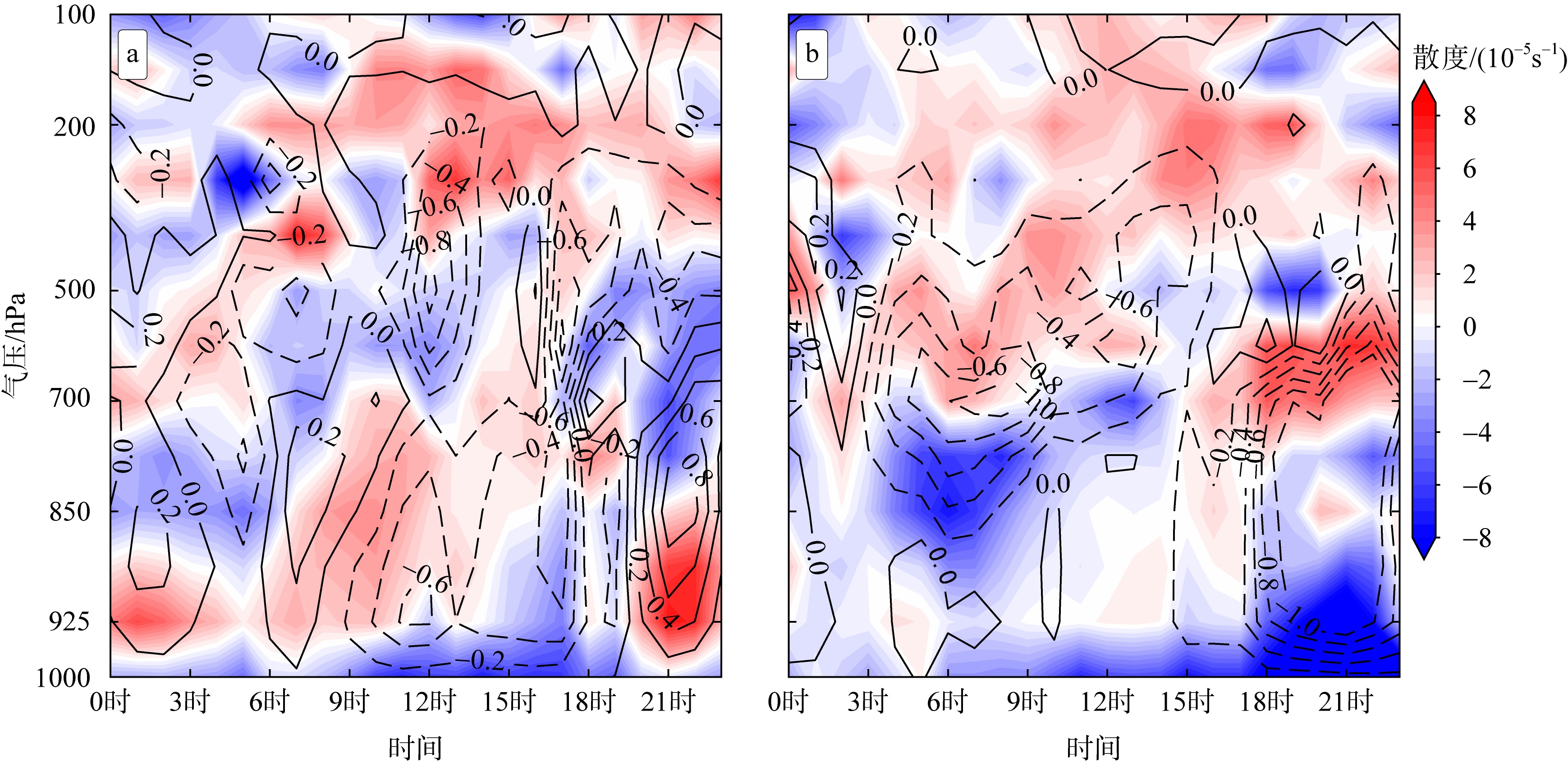
Fig. 8
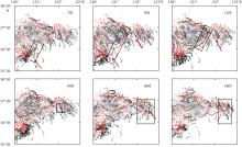
Fig. 9
Ground mapping at different times on 14 June, 2022"
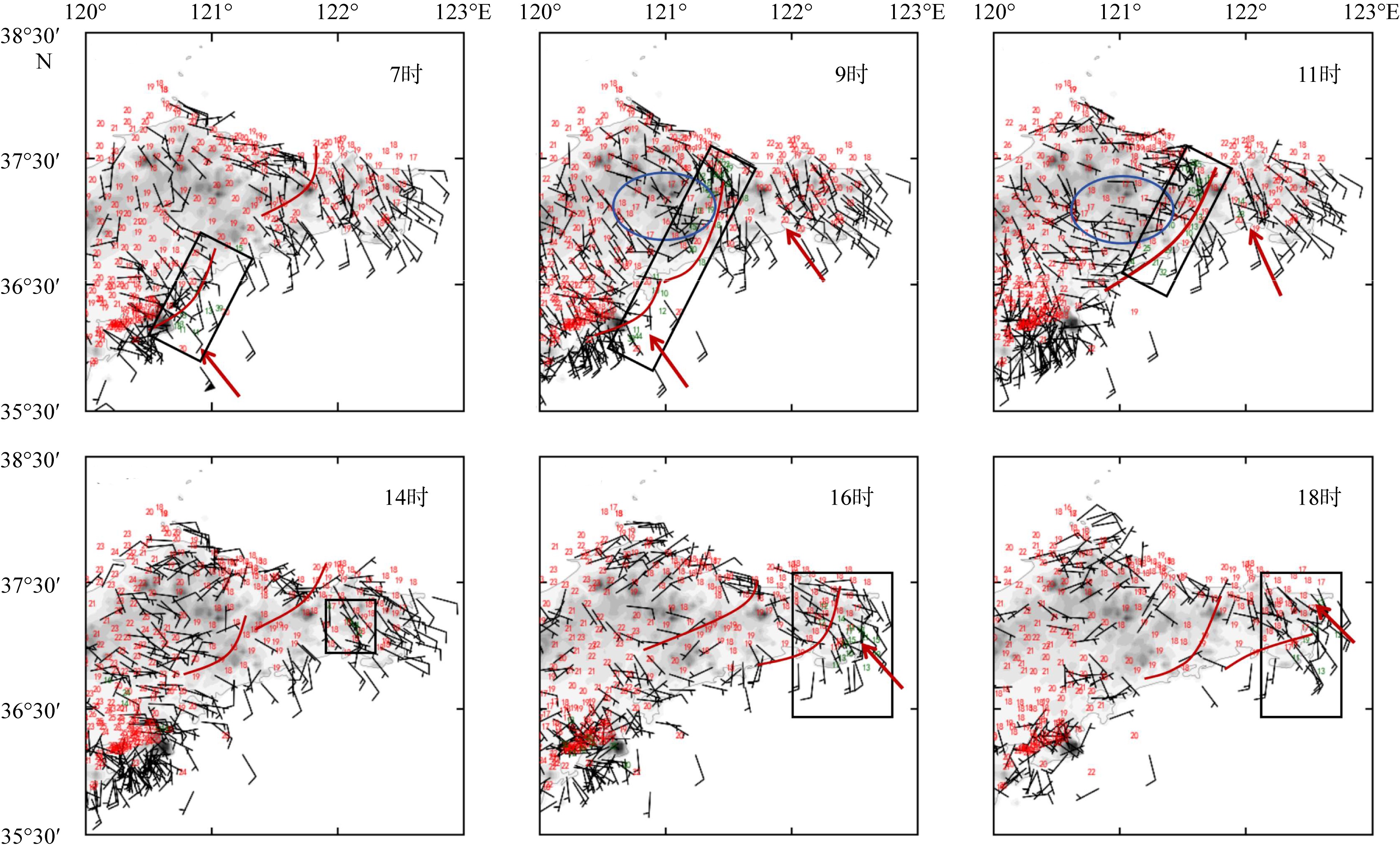
Fig. 9
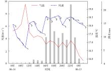
Fig. 10
Hourly factors of Wawushi Station from 08:00 CST on June 14 to 01:00 CST on June 15, 2022"
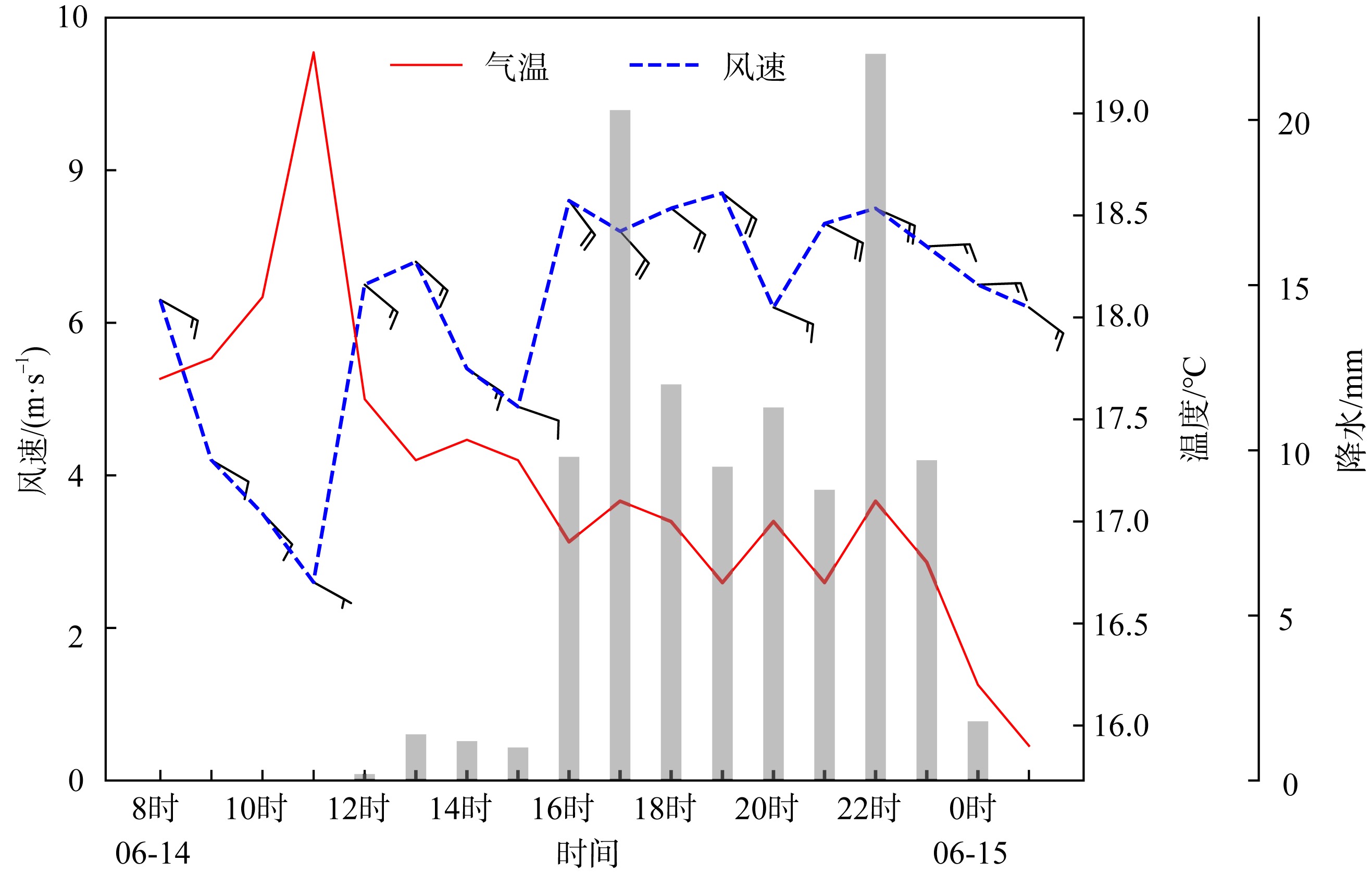
Fig. 10
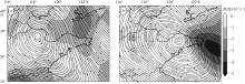
Fig. 11
925hPa flow field and dispersion at 08:00 CST (a) and 18:00 CST (b) on June 14, 2022"

Fig. 11
Fig. 12
Zonal profile of temperature anomaly and frontogenesis function at 37°15′ N on June 14, 2022. (a) 11:00; (b) 16:00; (c) 19:00; (d) 21:00"

Fig. 12
Fig. 13
The local variation of the average vorticity superimposed on the divergence (a), the average absolute vorticity advection term (b), the vorticity vertical transport term (c), the divergence term (d), and the tilting term (e) in the low vortex region (36°—38°N, 120°—122°30′E) of the Shandong Peninsula on June 14, 2022"
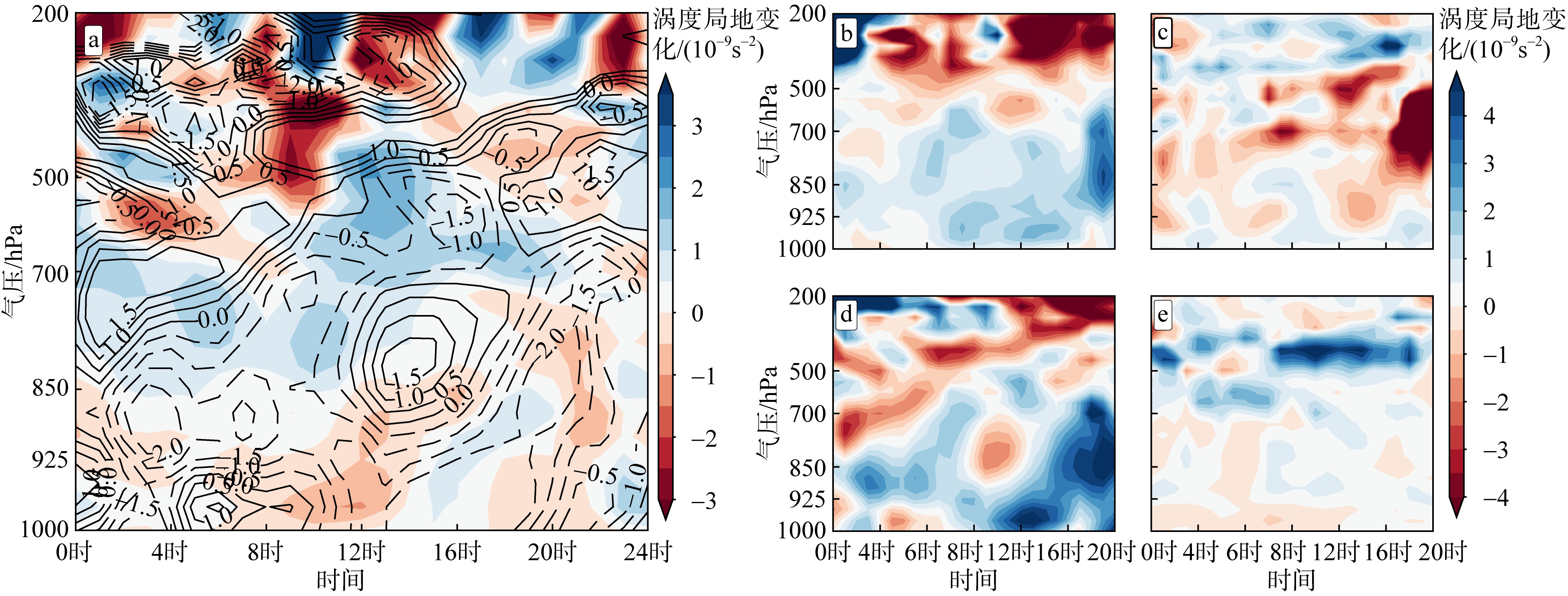
Fig. 13
| [1] |
陈涛, 陈博宇, 于超, 等, 2020. 华南前汛期锋面对流系统和暖区对流系统的多尺度特征和集合预报敏感性对比分析[J]. 气象, 46(9): 1129-1142.
|
|
|
|
| [2] |
邓承之, 张焱, 李强, 等, 2023. 四川盆地一次暖性西南低涡大暴雨的中尺度分析[J]. 暴雨灾害, 42(1): 24-36.
|
|
|
|
| [3] |
冯晋勤, 刘铭, 蔡菁, 2018. 闽西山区“7·22”极端降水过程中尺度对流特征[J]. 应用气象学报, 29(6): 748-758.
|
|
|
|
| [4] |
高晓梅, 白莉娜, 郭蓉, 等, 2023. 台风“利奇马”北上锋生导致山东省创纪录暴雨天气学成因分析[J]. 热带气象学报, 2023, 39(2): 145-158.
|
|
|
|
| [5] |
龚琬丁, 周玉淑, 钟珊珊, 等, 2023. 山东地区一次夏季极端暴雨中尺度系统发展演变过程及机理分析[J]. 大气科学, 47(3): 786-804.
|
|
|
|
| [6] |
何编, 孙照渤, 李忠贤, 2012. 一次华南持续性暴雨的动力诊断分析和数值模拟[J]. 大气科学学报, 35(4): 466-476.
|
|
|
|
| [7] |
侯淑梅, 孙兴池, 范苏丹, 等, 2014. 切变线冷区和暖区暴雨落区分析[J]. 大气科学学报, 37(3): 333-343.
|
|
|
|
| [8] |
黄莉, 詹莹玉, 孙莹, 等, 2011. “黑格比”后期异常强降水形成机理分析[J]. 热带海洋学报, 30(6): 57-63.
doi: 10.11978/j.issn.1009-5470.2011.06.057 |
|
|
|
| [9] |
李卓, 黎伟标, 张奡褀, 2022. 台风登陆前华南地区降水日变化特征分析[J]. 热带海洋学报, 41(2): 26-37.
doi: 10.11978/2021045 |
|
doi: 10.11978/2021045 |
|
| [10] |
林慧敏, 闵锦忠, 朱利剑, 等, 2023. 太行山地形在“7·19”华北持续性低涡暴雨中的作用[J]. 气象科学, 43(1): 46-58.
|
|
|
|
| [11] |
林晓霞, 冯业荣, 张诚忠, 等, 2017. 华南一次暴雨过程热力和动力特征的诊断分析[J]. 热带气象学报, 33(6): 975-984.
|
|
|
|
| [12] |
蒙伟光, 张艳霞, 袁金南, 等, 2014. 华南沿海2011年7月15—18日持续暴雨过程中的季风槽与中尺度对流系统相互作用[J]. 气象学报, 72(3): 508-525.
|
|
|
|
| [13] |
覃皓, 王志毅, 石怡宁, 等, 2023. 广西沿海一次冬季暖区暴雨的多尺度能量诊断[J]. 暴雨灾害, 42(3): 283-292.
|
|
|
|
| [14] |
沈新勇, 张弛, 高焕妍, 等, 2020. 三类高空冷涡的划分及其动态合成分析[J]. 暴雨灾害, 39(1): 1-9.
|
|
|
|
| [15] |
王宁, 张立凤, 彭军, 等, 2014. 局部地形对北京“7. 21”特大暴雨影响的数值研究[J]. 暴雨灾害, 33(1): 10-18.
|
|
|
|
| [16] |
尉英华, 陈宏, 何群英, 等, 2019. 渤海西岸偏东风对天津局地大暴雨的影响分析[J]. 气象, 45(1): 61-72.
|
|
|
|
| [17] |
吴乃庚, 温之平, 邓文剑, 等, 2020. 华南前汛期暖区暴雨研究新进展[J]. 气象科学, 40(5): 605-616.
|
|
|
|
| [18] |
叶朗明, 吴乃庚, 张华龙, 等, 2019. 海陆风和地形对一次弱天气背景下暖区特大暴雨的影响分析[J]. 暴雨灾害, 38(6): 597-605.
|
|
|
|
| [19] |
郑丽娜, 孙兴池, 孟伟, 2015. 夏季两次低槽冷锋型暴雨成因对比分析[J]. 气象科技, 43(6): 1133-1141.
|
|
|
|
| [20] |
郑丽娜, 孙兴池, 2016. 气旋类山东暴雨过程天气学特征分析[J]. 沙漠与绿洲气象, 10(4): 74-80.
|
|
|
|
| [21] |
郑铮, 潘灵杰, 钱燕珍, 等, 2021. 台风“利奇马”造成浙江沿海极端强降水的演变特征[J]. 干旱气象, 39(2): 269-278.
|
|
|
|
| [22] |
|
| [23] |
|
| [24] |
|
| [25] |
|
| [26] |
|
| [27] |
|
| [28] |
|
| [29] |
|
| [30] |
doi: 10.1007/s00376-019-9021-1 |
| [31] |
|
| [32] |
|
| [1] | LUO Shihao, JING Zhiyou, YAN Tong, ZHENG Ruixi, CAO Haijin, QI Yiquan. Seasonal variability of submesoscale flows in the Kuroshio Extension [J]. Journal of Tropical Oceanography, 2021, 40(1): 1-11. |
| [2] | LUO Shihao, JING Zhiyou, QI Yiquan, XIE Qiang. Numerical study on sub-mesoscale processes in the northern South China Sea [J]. Journal of Tropical Oceanography, 2016, 35(5): 10-19. |
|
||