
热带海洋学报 ›› 2026, Vol. 45 ›› Issue (2): 160-172.doi: 10.11978/2025065CSTR: 32234.14.2025065
大鹏湾海域海漂垃圾迁移路径研究
邱家福( ), 刘佳鑫, 段晓伟, 陈胜利()
清华大学深圳国际研究生院海洋工程研究院
-
收稿日期:2025-05-14修回日期:2025-07-17出版日期:2026-03-10发布日期:2026-03-26 -
通讯作者:陈胜利。email: shenglichen@sz.tsinghua.edu.cn -
作者简介:邱家福(1999—), 男, 江西省抚州市人, 硕士研究生。email: qiujiafu1999@163.com
-
基金资助:深圳市重大专项可持续发展专项(KCXFZ20240903093900002); 广东省粤港澳团队联合项目(2022B1515130006)
A study on the migration paths of floating debris in the sea area of Dapeng Bay
QIU Jiafu(), LIU Jiaxin, DUAN Xiaowei, CHEN Shengli()
Institute for Ocean Engineering ,Shenzhen International Graduate School, Tsinghua University
-
Received:2025-05-14Revised:2025-07-17Online:2026-03-10Published:2026-03-26 -
Contact:CHEN Shengli. email: shenglichen@sz.tsinghua.edu.cn -
Supported by:Shenzhen Major Special Project - Sustainable Development Special Project(KCXFZ20240903093900002); Guangdong-Hong Kong-Macao Joint Funding Program(2022B1515130006)
摘要:
大鹏湾是深圳市重要旅游区域, 每年海滩垃圾、海漂垃圾量达上百吨。文章针对大鹏湾区域, 以海流模型(finite volume community ocean model, FVCOM)为基础建立了大鹏湾区域海洋数值模型, 并将模拟的流场和风场数据输入拉格朗日质点追踪模型OpenDrift, 结合观测浮标数据对大鹏湾海漂垃圾的迁移过程开展研究。结果表明, 大鹏湾常见风为东风、东北风和东南风, 在这些风向下, 70%以上的大鹏湾北部和东部的近岸海漂垃圾会聚集在盐田港及其东南部香港的吉澳洲岛、黄泥洲岛、娥眉洲岛、往湾洲岛区域。在大鹏湾海上垃圾日常清理工作中, 需要重点关注上述区域。通过对比不同月份和潮汐的试验, 发现风向主导海漂垃圾整体的运动方向, 风速影响漂移时间和漂移距离, 潮流差异影响搁浅区域和抵达各区域的海漂垃圾数量。
中图分类号:
- P762.8
引用本文
邱家福, 刘佳鑫, 段晓伟, 陈胜利. 大鹏湾海域海漂垃圾迁移路径研究[J]. 热带海洋学报, 2026, 45(2): 160-172.
QIU Jiafu, LIU Jiaxin, DUAN Xiaowei, CHEN Shengli. A study on the migration paths of floating debris in the sea area of Dapeng Bay[J]. Journal of Tropical Oceanography, 2026, 45(2): 160-172.
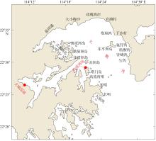
图1
大鹏湾区域主要地形及测站分布图 该图基于自然资源部标准地图服务网站下载的审图号为GS(2019)4342号的标准地图制作, 底图无修改。红点表示测站位置"
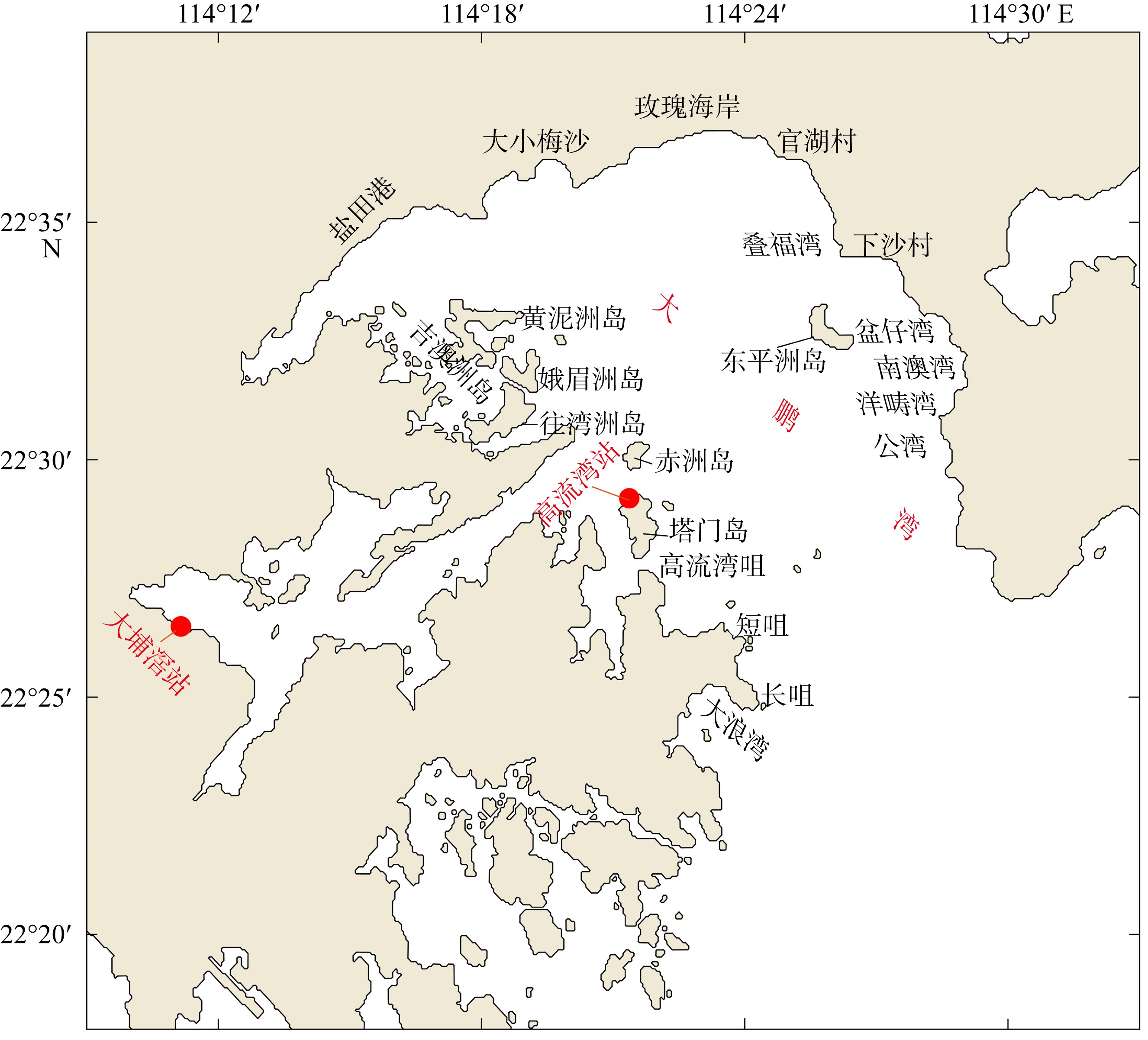
图1

图2
浮标结构示意图"
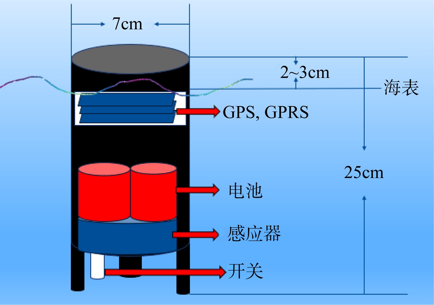
图2
图3
模型区域网格图"

图3
表1
FVCOM模型配置及参数化方案选择表"
| 模型相关参数 | 具体配置及参数选择 |
|---|---|
| 开边界驱动 | 潮汐(OTIS)、温盐(HYCOM) |
| 海表强迫 | 风(ECMWF) 气温、气压、长短波辐射和蒸发降水(NCEP/NCAR) |
| 计算时段 | 202301010000—202302010000 (UTC) 202304010000—202305010000 (UTC) 202307010000—202308010000 (UTC) 202310010000—202311010000 (UTC) |
| 计算时间步长 | 外模1s、内模10s |
| 水平扩散 | Smagorinsky湍流闭合方案 |
| 垂向扩散 | MY-2.5阶垂向混合参数化方案 |
| 结果输出频率 | 5min·次-1 |
表1
表2
2023年不同月份大鹏湾风场情况表"
| 时间 | 主要风向(占比) | 最频风速/(m·s-1)区间 | 当月平均风速/(m·s-1) |
|---|---|---|---|
| 2023年1月 | 东北风(>70%) | 4~5 | 4.47 |
| 2023年4月 | 东风(38%)、东北风(36%) | 3~4 | 4.49 |
| 2023年7月 | 西南风(40%)、东南风(30%) | 3~4 | 3.41 |
| 2023年10月 | 东南风(54%)、东风(20%) | 3~4 | 4.49 |
表2
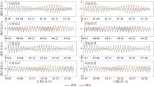
图4
大埔滘站和高流湾站模型天文潮水位模拟结果与实测数据(2023年)对比图"
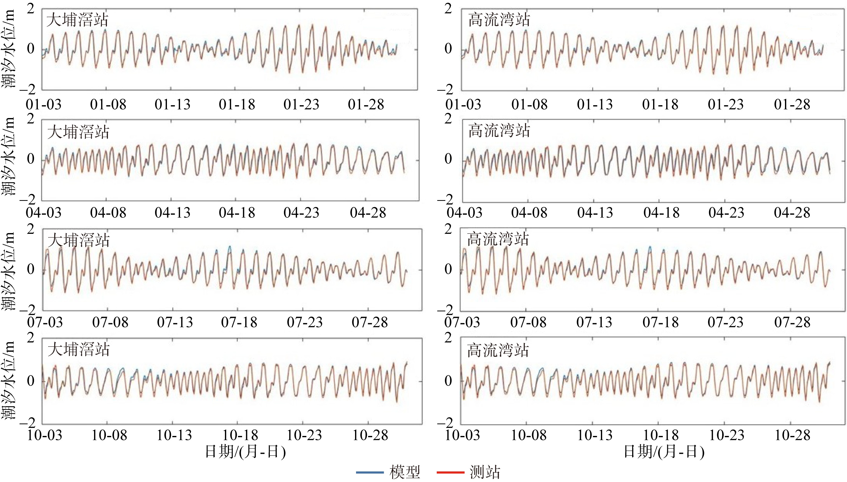
图4
图5
OpenDrift模型模拟轨迹与实际浮标轨迹对比图 a. 2023年4月23日16:00释放; b. 2023年4月20日10:59释放; c. 2023年4月21日16:00释放; d. 2023年4月21日16:20释放; e. 2023年4月19日14:00释放; f. 2023年4月20日13:00释放; g. 2023年4月21日16:25释放; h. 2023年4月20日17:05释放。该图基于自然资源部标准地图服务网站下载的审图号为GS(2019)4342号的标准地图制作, 底图无修改。图中黑色轨迹为实际浮标轨迹, 黑线远岸端点为浮标投放时初始位置, 红色圆点为轨迹模拟实验中粒子的初始投放位置, 彩色线为不同风漂移系数下模型模拟轨迹, 每段轨迹模拟时长为12h"
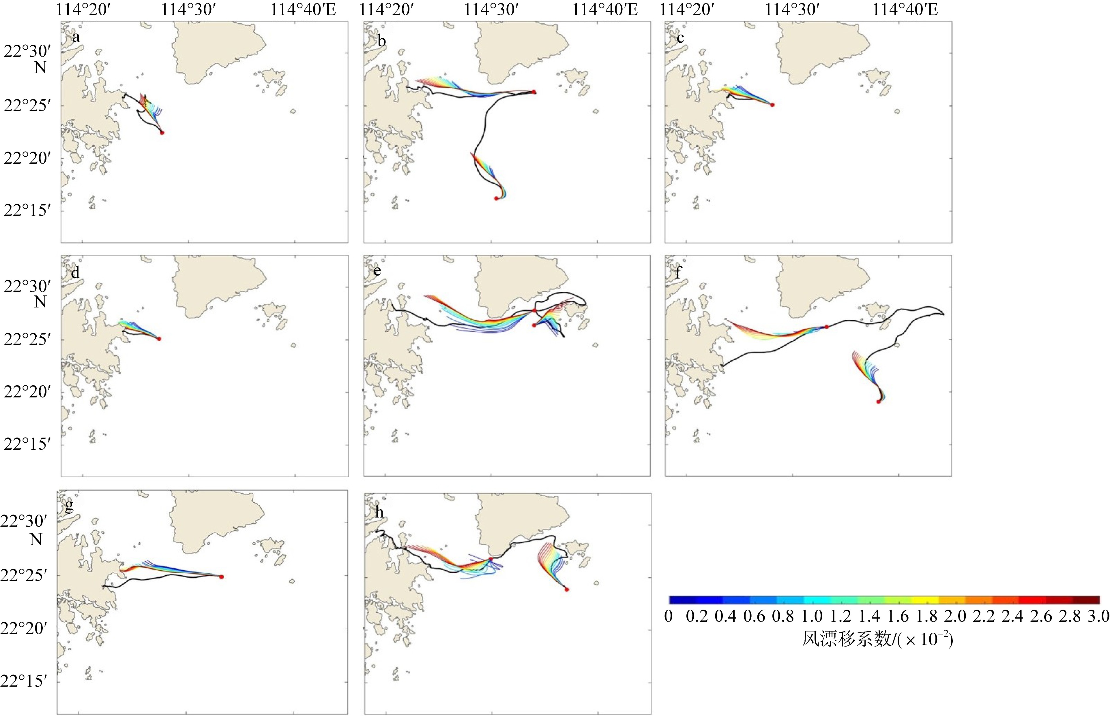
图5
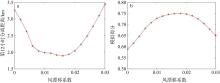
图6
不同风漂移系数下第12小时平均分离距离(a)及模拟平均得分(b)"
图6
图7
不同风向不同潮汐时期下沙区域粒子试验结果图 a. 大潮时期东南风; b. 大潮时期东风; c. 大潮时期东北风; d. 小潮时期东南风; e. 小潮时期东风; f. 小潮时期东北风。该图基于自然资源部标准地图服务网站下载的审图号为GS(2019)4342号的标准地图制作, 底图无修改。图示为风速2m·s-1时试验结果, 蓝色区域为粒子投放区, 总计均匀投放约2000个粒子, 红色点为粒子最终位置, 灰色曲线为粒子运动轨迹, 红色箭头为风速增大时粒子运动轨迹及搁浅区域的偏移趋势, 红色方框为粒子最终的搁浅聚集区域"
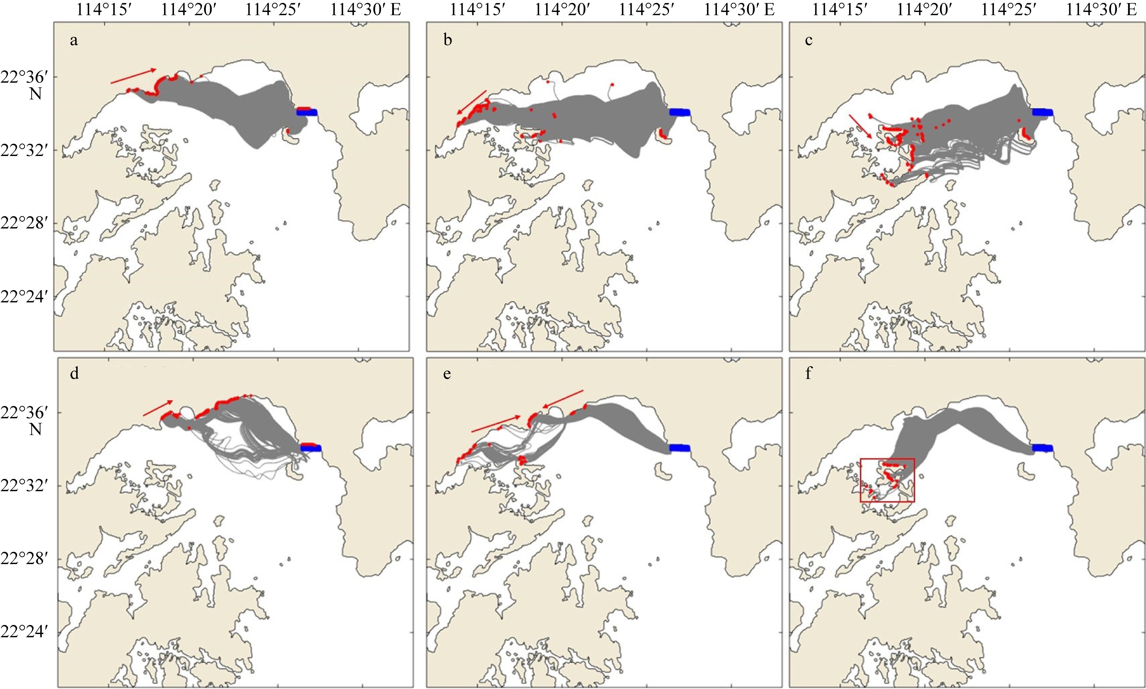
图7
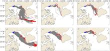
图8
不同风向不同潮汐时期大小梅沙区域粒子试验结果图 a. 大潮时期东南风; b. 大潮时期东风; c. 大潮时期东北风; d. 小潮时期东南风; e. 小潮时期东风; f. 小潮时期东北风。该图基于自然资源部标准地图服务网站下载的审图号为GS(2019)4342号的标准地图制作, 底图无修改。图示为风速2m·s-1时试验结果, 蓝色区域为粒子投放区, 总计均匀投放约6000个粒子, 红色点为粒子最终位置, 灰色曲线为粒子运动轨迹, 红色箭头显示风速增大时粒子运动轨迹及搁浅区域的偏移趋势"

图8

图9
不同月份不同潮汐时期大鹏湾北部及东部近海区域粒子试验结果图 a. 1月大潮时期; b. 1月小潮时期; c. 4月大潮时期; d. 4月小潮时期; e. 7月大潮时期; f. 7月小潮时期; g. 10月大潮时期; h. 10月小潮时期。该图基于自然资源部标准地图服务网站下载的审图号为GS(2019)4342号的标准地图制作, 底图无修改。图中蓝色区域为粒子投放区, 沿海岸均匀投放约6000个粒子, 红色点为粒子最终位置, 灰色曲线为粒子运动轨迹"
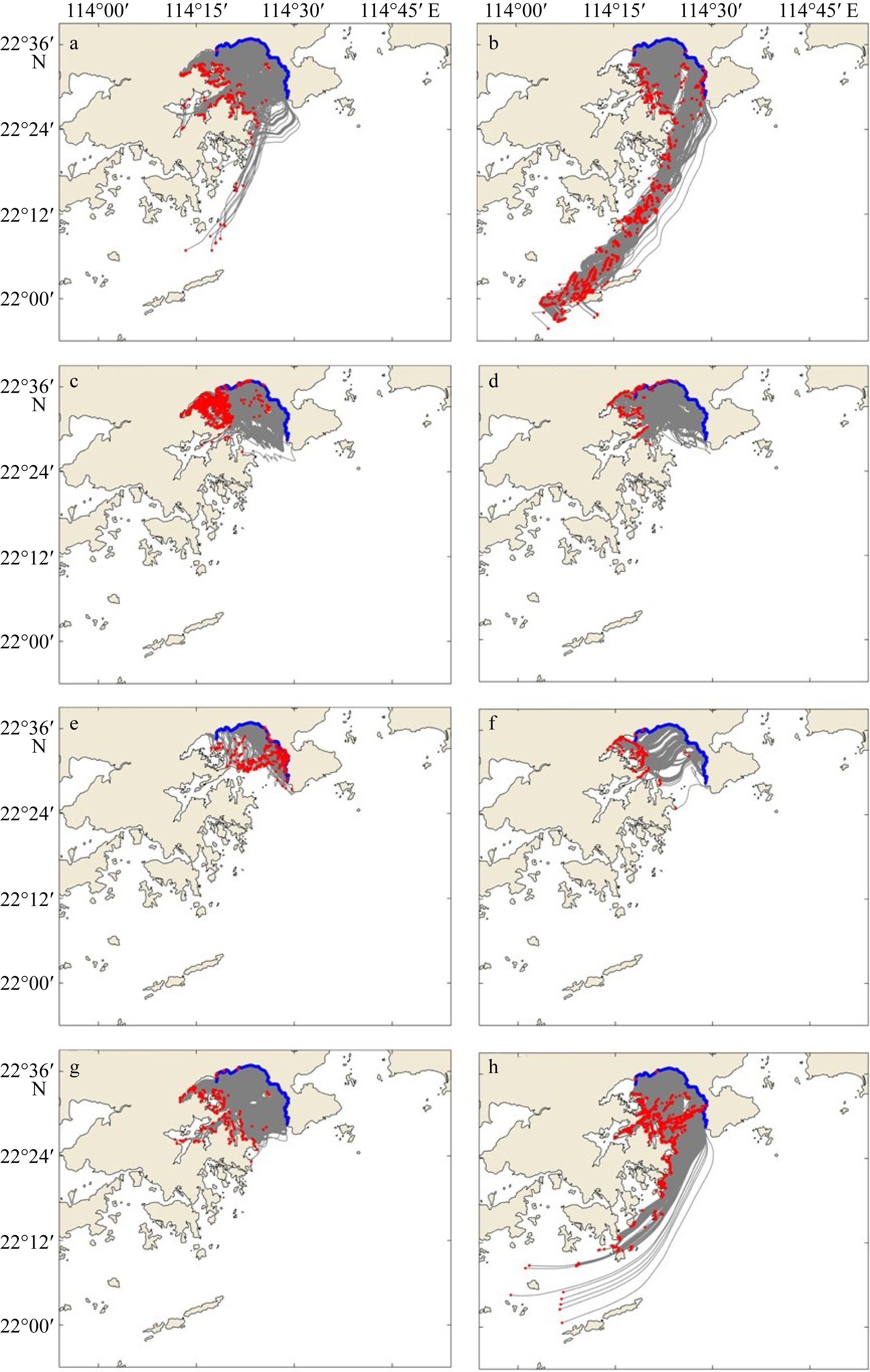
图9
表3
不同月份大鹏湾北部及东部近海区域粒子去向试验结果表"
| 时间 | 潮汐 | 主要风 | 粒子去向主要聚集区域 |
|---|---|---|---|
| 2023年1月 | 大潮 | 东北风 | 大鹏湾西侧海岸 |
| 小潮 | 东北风 | 大鹏湾西侧海岸、湾外(香港南部, 出湾口往西南方向运动至珠江口) | |
| 2023年4月 | 大潮 | 东风、东北风 | 盐田港、吉澳洲岛、黄泥洲岛、娥眉洲岛、往湾洲岛 |
| 小潮 | 东风、东北风 | 盐田港、吉澳洲岛、黄泥洲岛、娥眉洲岛、往湾洲岛 | |
| 2023年7月 | 大潮 | 西南风 | 南澳湾及其周边区域 |
| 小潮 | 东南风 | 盐田港、吉澳洲岛、黄泥洲岛、娥眉洲岛、往湾洲岛 | |
| 2023年10月 | 大潮 | 东风、东南风 | 大鹏湾西侧海岸及西北角 |
| 小潮 | 东风、东南风 | 大鹏湾西侧海岸、湾外(香港南部, 出湾口往西南方向运动至珠江口) |
表3
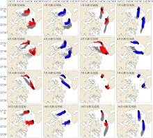
图10
不同月份不同潮汐时期各动力强迫分量下粒子运动轨迹图 该图基于自然资源部标准地图服务网站下载的审图号为GS(2019)4342号的标准地图制作, 底图无修改。图中黑色区域为粒子投放区, 每个区域投放约200个粒子, 红色、蓝色、灰色曲线分别为流场单独作用、风场单独作用、流场与风场共同作用下粒子运动轨迹"
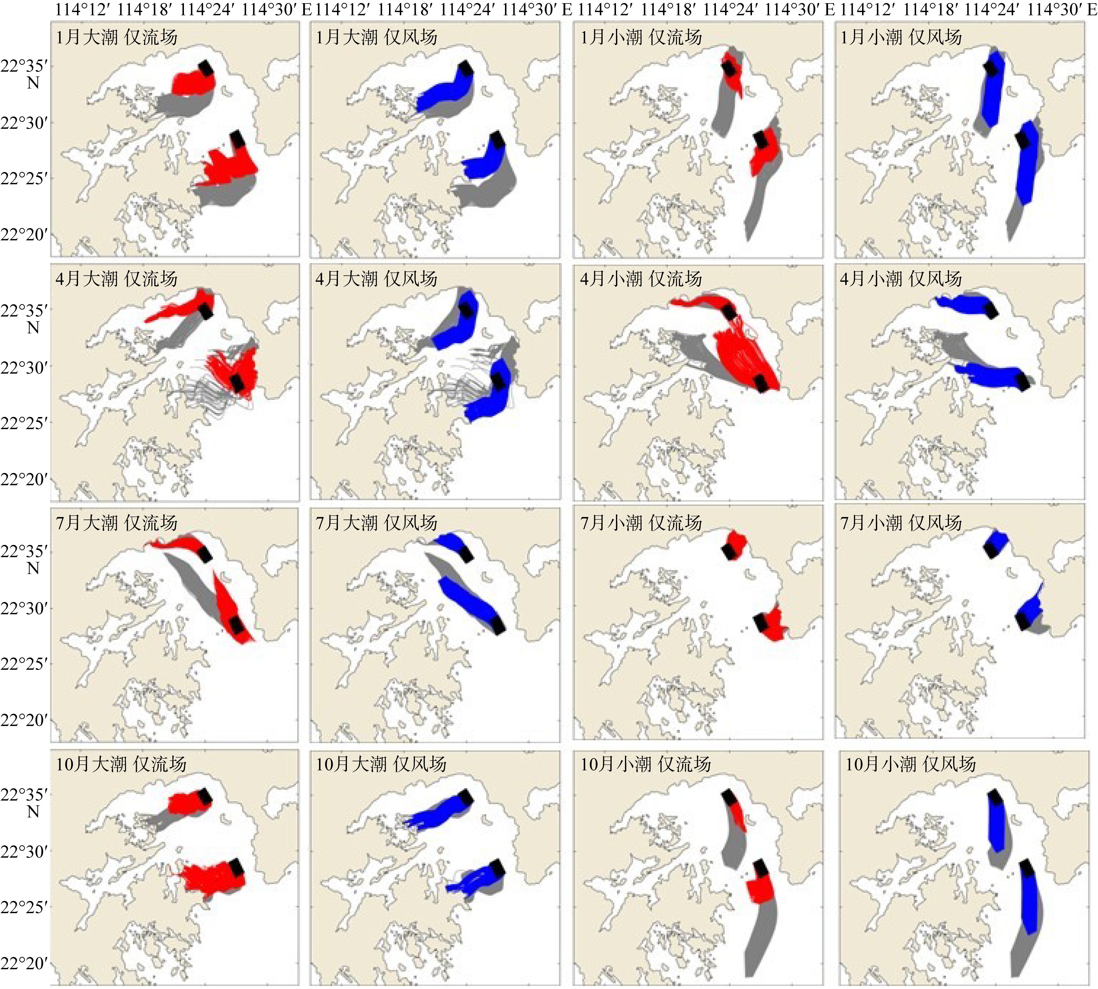
图10
表4
各月份风场、流场单独作用与共同作用下粒子轨迹归一化累计拉格朗日分离距离(s)表"
| 区域 | 潮汐 | 驱动因素 | 1月 | 4月 | 7月 | 10月 |
|---|---|---|---|---|---|---|
| 靠近湾顶 | 大潮 | 仅流场 | 0.4839 | 0.2968 | 0.5702 | 0.5421 |
| 仅风场 | 0.2682 | 0.3213 | 0.2095 | 0.2394 | ||
| 小潮 | 仅流场 | 0.3477 | 0.3684 | 0.3136 | 0.5676 | |
| 仅风场 | 0.1264 | 0.2084 | 0.1783 | 0.1343 | ||
| 靠近湾口 | 大潮 | 仅流场 | 0.3394 | 0.3431 | 0.5900 | 0.3158 |
| 仅风场 | 0.3672 | 0.5772 | 0.1988 | 0.2335 | ||
| 小潮 | 仅流场 | 0.3212 | 0.5227 | 0.2264 | 0.7430 | |
| 仅风场 | 0.2845 | 0.3615 | 0.5181 | 0.5317 |
表4
| [1] |
陈熙, 高翊尧, 凌玮, 等, 2019. 辽东湾河口区海洋垃圾赋存特征及管理对策[J]. 环境科学研究, 32(12): 1959-1965.
|
|
|
|
| [2] |
褚芹芹, 张万磊, 吴玲娟, 等, 2019. 秦皇岛近岸海域保守污染物漂移的数值模拟与分析[J]. 海洋预报, 36(5): 39-46.
|
|
|
|
| [3] |
郭民权, 曾银东, 李雪丁, 等, 2014. 平潭近岸海域浮子漂移轨迹及其数值模拟[J]. 应用海洋学学报, 33(4): 449-454.
|
|
|
|
| [4] |
刘璇, 孙鑫, 朱宏楠, 等, 2021. 我国近海漂浮垃圾污染现状及应对建议[J]. 环境卫生工程, 29(5): 23-29.
|
|
|
|
| [5] |
秦绮蔚, 2022. 大鹏湾将建国家级海洋牧场[N]. 深圳特区报, 2022-08-16(A07) (in Chinese).
|
| [6] |
孙承君, 蒋凤华, 李景喜, 等, 2016. 海洋中微塑料的来源、分布及生态环境影响研究进展[J]. 海洋科学进展, 34(4): 449-461.
|
|
|
|
| [7] |
王倩, 向静雅, 陈钦冬, 等, 2020. 深圳市全海岸线垃圾成分及其特性研究[J]. 环境卫生工程, 28(2): 30-36.
|
|
|
|
| [8] |
许敬波, 袁承仪, 2024. 基于OpenDrift模型的渤海微塑料分布与输运数值模拟[J]. 天津科技大学学报, 39(6): 38-48.
|
|
|
|
| [9] |
于海晴, 梁迪隽, 谭全银, 等, 2018. 海洋垃圾和微塑料污染问题及其国际进程[J]. 世界环境, (2): 50-53.
|
|
|
|
| [10] |
余学芳, 朱嵩, 李继选, 2016. 海湾潮流运动的三维数值模拟研究[J]. 人民黄河, 38(3): 22-24.
|
|
|
|
| [11] |
曾银东, 郭民权, 方许闻, 等, 2023. 福建近海漂移物漂移轨迹分析及模拟[J]. 厦门大学学报(自然科学版), 62(3): 435-443.
|
|
|
|
| [12] |
张哲然, 胡俊洋, 周凯, 等, 2023. 不同类型台风气象场对深圳近海海域风暴潮模拟的比较研究: 以台风“山竹”为例[J]. 热带海洋学报, 42(6): 1-14.
|
|
|
|
| [13] |
郑沛楠, 宋军, 张芳苒, 等, 2008. 常用海洋数值模式简介[J]. 海洋预报, 25(4): 108-120.
|
|
|
|
| [14] |
周倩, 2016. 典型滨海潮滩及近海环境中微塑料污染特征与生态风险[D]. 烟台: 中国科学院烟台海岸带研究所.
|
|
|
|
| [15] |
doi: 10.1016/j.rsase.2025.101475 |
| [16] |
doi: 10.1016/j.jmarsys.2005.09.016 |
| [17] |
doi: 10.1175/1520-0426(2003)020<0159:AUGFVT>2.0.CO;2 |
| [18] |
doi: 10.1016/j.rse.2019.01.001 |
| [19] |
doi: 10.5194/gmd-11-1405-2018 |
| [20] |
doi: 10.1016/S0079-6611(98)00008-1 |
| [21] |
doi: 10.1016/j.ecss.2024.108919 |
| [22] |
doi: 10.1016/j.marpolbul.2024.117494 |
| [23] |
doi: 10.1016/j.jmarsys.2023.103917 |
| [24] |
doi: 10.1002/qj.v146.730 |
| [25] |
doi: 10.1016/j.marpolbul.2022.114362 |
| [26] |
doi: 10.1175/1520-0477(1996)077<0437:TNYRP>2.0.CO;2 |
| [27] |
doi: 10.1007/s13131-019-1425-3 |
| [28] |
|
| [29] |
|
| [30] |
|
| [31] |
doi: 10.1016/j.ocemod.2004.08.002 |
| [32] |
doi: 10.3390/rs15153806 |
| [33] |
doi: 10.1088/1748-9326/ab6d7d |
| [34] |
doi: 10.4031/MTSJ.55.5.7 |
| [1] | 乔光全, 徐润刚. 广海湾海域潮位多峰特征及原因分析[J]. 热带海洋学报, 2025, 44(6): 12-20. |
| [2] | 刘文明, 刘羽乔. 液化天然气接收站冷排水余氯对近岸海域生态环境影响的三维数值模拟[J]. 热带海洋学报, 2025, 44(3): 217-223. |
| [3] | 王旭, 屈科, 王梓峻, 杨元平, 王超, 张良斌. 风对波状涌潮海塘越浪水动力特性影响的数值研究[J]. 热带海洋学报, 2024, 43(5): 116-130. |
| [4] | 吴鸿博, 罗锋, 陈治澎, 朱飞, 曾靖伟, 张弛, 李瑞杰. 红树林生态重建效果预测研究新模式[J]. 热带海洋学报, 2024, 43(4): 86-97. |
| [5] | 张哲然, 胡俊洋, 周凯, 张鹏晖, 邢久星, 陈胜利. 不同类型台风气象场对深圳近海海域风暴潮模拟的比较研究—以台风“山竹”为例*[J]. 热带海洋学报, 2023, 42(6): 1-14. |
| [6] | 严静, 韦惺. 珠江黄茅海河口地貌形态变化及其动力响应[J]. 热带海洋学报, 2023, 42(2): 9-20. |
| [7] | 张敏, 吴航星, 陆逸彬, 陆迪文, 米婕, 朱冬琳, 陈波. 海岸线围垦对广西钦州湾地形演变的影响分析[J]. 热带海洋学报, 2023, 42(2): 124-131. |
| [8] | 顾靖华, 朱建荣, 金智. 长江口宝钢码头溢油事故油膜漂移扩散数值模拟[J]. 热带海洋学报, 2022, 41(6): 159-170. |
| [9] | 邓国通, 刘敏聪, 邢久星, 申锦瑜, 周凯, 陈胜利. 深圳近海风暴潮影响因素分析[J]. 热带海洋学报, 2022, 41(3): 91-100. |
| [10] | 刘悦, 李丽, 翟晓辉, 周娟, 叶鹏浩, 黄盛东. 深圳大鹏湾一次球形棕囊藻藻华的发生过程及成因分析[J]. 热带海洋学报, 2022, 41(3): 164-171. |
| [11] | 王仁政, 单正垛, 孟思雨, 宫响. 南海北部次表层叶绿素最大值年际变化特征分析*[J]. 热带海洋学报, 2021, 40(6): 63-75. |
| [12] | 张华, 温茜茜, 彭世球. 莫桑比克海峡及其邻近海区正压潮流数值模拟与能量收支分析*[J]. 热带海洋学报, 2021, 40(2): 7-16. |
| [13] | 李娟, 刘军亮, 蔡树群. 台风“康森”产生的海洋近惯性能量的数值模拟研究[J]. 热带海洋学报, 2020, 39(2): 35-43. |
| [14] | 林夏艳, 董昌明, 陈大可. 台湾岛西南部一个暖涡的跨海盆粒子输运[J]. 热带海洋学报, 2018, 37(3): 9-18. |
| [15] | 武文, 严聿晗, 宋德海. 大亚湾的潮汐动力学研究——I.潮波系统的观测分析与数值模拟*[J]. 热带海洋学报, 2017, 36(3): 34-45. |
|
||