
Journal of Tropical Oceanography ›› 2021, Vol. 40 ›› Issue (3): 25-33.doi: 10.11978/YG2020011CSTR: 32234.14.YG2020011
• Review • Previous Articles Next Articles
New development on crustal structures of the Manila subduction in the eastern South China Sea
ZHAO Minghui1,2,6( ), CHENG Jinhui1,2,6, GAO Jinwei3, SUN Longtao1,2, XU Ya4, ZHANG Jiazheng1,2, DU Feng5
- 1. Key Laboratory of Ocean and Marginal Sea Geology, South China Sea Institute of Oceanology, Chinese Academy of Sciences, Guangzhou 511458, China
2. Guangdong Laboratory of Marine Science and Engineering, Guangzhou 511458, China
3. Institute of Deep-sea Science and Engineering, Chinese Academy of Sciences, Sanya 572000, China
4. Key Laboratory of Petroleum Resources Research, Institute of Geology and Geophysics, Chinese Academy of Sciences, Beijing 100029, China
5. Hubei Key Laboratory of Earthquake Early Warning, Hubei Earthquake Agency, Wuhan 430071, China
6. University of Chinese Academy of Sciences, Beijing 100049, China
-
Received:2020-12-29Revised:2021-01-20Online:2021-05-10Published:2021-01-20 -
Contact:ZHAO Minghui E-mail:mhzhao@scsio.ac.cn -
Supported by:Natural Science Foundation of China(91958212);Natural Science Foundation of China(41730532);Natural Science Foundation of China(91428204);Natural Science Foundation of China(91858212);Key Special Project for Introduced Talents Team of Southern Marine Science and Engineering Guangdong Laboratory (Guangzhou)(GML2019ZD0204);Guangdong Natural Science Foundation research team project(2017A030312002)
CLC Number:
- P738
Cite this article
ZHAO Minghui, CHENG Jinhui, GAO Jinwei, SUN Longtao, XU Ya, ZHANG Jiazheng, DU Feng. New development on crustal structures of the Manila subduction in the eastern South China Sea[J].Journal of Tropical Oceanography, 2021, 40(3): 25-33.
share this article
Add to citation manager EndNote|Reference Manager|ProCite|BibTeX|RefWorks
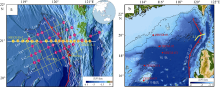
Fig. 1
Significant scientific experiments and key data acquired during this project. Circles and a triangle represent Ocean Bottom Seismometers (OBS) stations recording signals caused by active airgun-shooting and passive earthquakes, respectively, in (a). Circles in (b) indicate the Ocean Bottom ElectroMagnetometers (OBEM) stations; and the seismic line L1 corresponds to the multichannel reflection profile in Fig. 4"
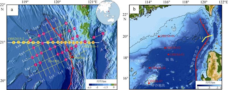
Fig. 1
Fig. 2
Velocity structure along the profile OBS2015-2. (a) and (b) showing the forward and inverted velocity structures, respectively. (c) and (d) are one-dimensional velocity structures beneath each OBS station, which was extracted from the forward (a) and inverse velocity structures (b), respectively"
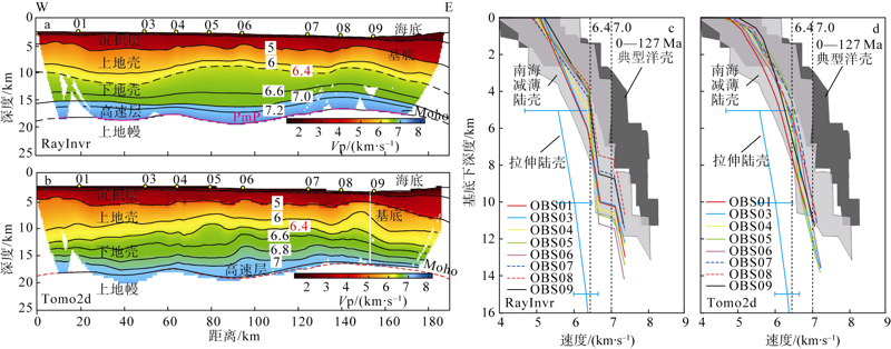
Fig. 2
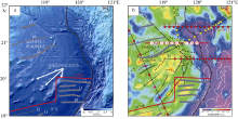
Fig. 3
Continent-Ocean Boundaries in the northeastern continental margin of the South China Sea. (a) The bathymetry map in the northeastern SCS. (b) The free-air gravity map in the northeastern SCS. Grey lines indicate magnetic anomalies, and black lines with crosses in (b) indicate structural highs (elongated volcanic intrusions) referenced by Briais et al (1993), Hsu et al (2004), and Sibuet et al (2016)"

Fig. 3
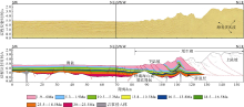
Fig. 4
Multi-channel seismic reflection profile (upper) and interpretation (lower) of accretionary prism of northern Manila subduction (after Gao et al, 2018). The location of this profile is shown in Fig. 1b"
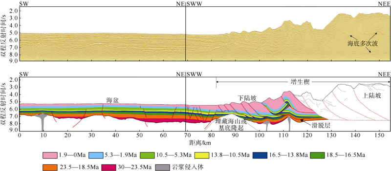
Fig. 4
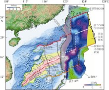
Fig. 5
The whole oceanic crust domain when the SCS seafloor spreading stopped (15Ma); after Zhao et al (2019). The subducted SCS plate (dVP) is unfolded and restored on the surface of the Earth, and the plate extends 400-500 km east along the Manila trench. The green line is the current SCS domain (Sibuet et al, 2016), and the east part is the domain of subducted SCS oceanic crust. The grey shaded area (<100 km width) is probable artifacts. The SCS oceanic domain, characterized by N055°, N075° and N085° seafloor spreading directions, is delimited by pink, yellow and light blue areas, respectively. The red double dashed line indicates the extinct spreading ridge of the SCS (He et al, 2016), the red line indicates COB, and the circles indicate the location of IODP drilling sites"
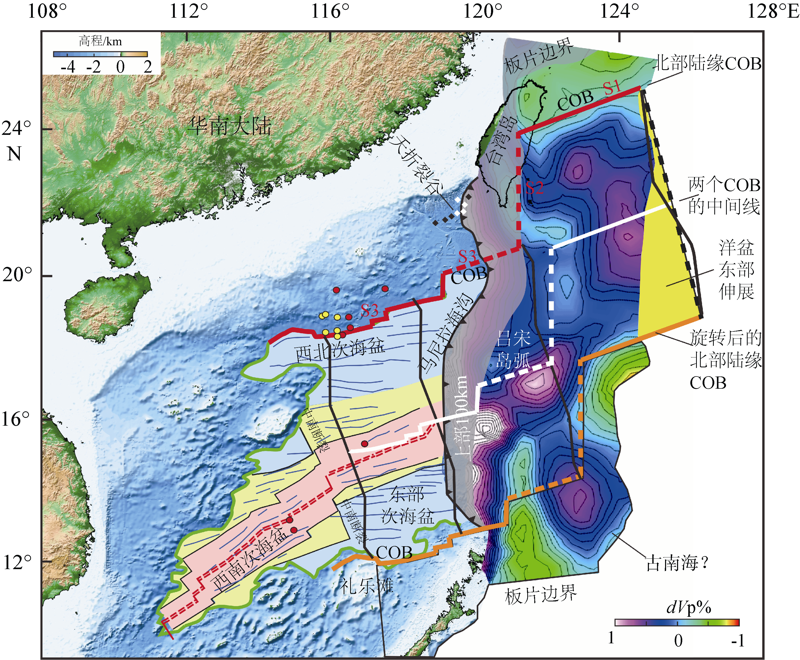
Fig. 5
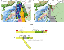
Fig. 6
The kinematic evolution of the SCS and PSP since 15 Ma (after Zhao et al, 2019). (a) About 15 Ma, the oceanic crust of the SCS started to subduct along the left shear plate boundary to the bottom of the PSP. (b)The current location of the emplacement of the Philippine belt, the accretion of the western part of the Huatung Basin and the western Luzon arc. (c) A simplified diagram of profile AA’ and BB’ located in (a) and (b), respectively. Dark green: early Cretaceous HB; light green: current PSP; extension of the HB within the portion of PSP in light grey, which will subduct to be disappeared; yellow area: eastern extension of the SCS at the end of seafloor spreading; orange domain: part of East Asian Plate defined by Wu et al (2016); and pink domain: the northeastern extension of the Sulu Sea"

Fig. 6
| [1] | 高金尉, 吴时国, 姚永坚, 等, 2018. 马尼拉俯冲带北段增生楔前缘构造变形和精细结构[J]. 地球物理学报, 61(7):2845-2858. |
| GAO JINWEI, WU SHIGUO, YAO YONGJIAN, et al, 2018. Tectonic deformation and fine structure of the frontal accretionary wedge, northern Manila subduction zone[J]. Chinese Journal of Geophysics, 61(7):2845-2858 (in Chinese with English abstract). | |
| [2] | 黄奇瑜, 2017. 台湾岛的年龄[J]. 中国科学: 地球科学, 47(4):394-405. |
| HUANG QIYU, 2017. Geological ages of Taiwan stratigraphy and tectonic events[J]. Scientia Sinica Terrae, 47(4):394-405 (in Chinese with English abstract). | |
| [3] | 李春峰, 周祖翼, 李家彪, 等, 2007. 台湾岛南部海域的前碰撞构造地球物理特征[J]. 中国科学(D辑: 地球科学), 37(5):649-659. |
| [4] | 李家彪, 金翔龙, 阮爱国, 等, 2004. 马尼拉海沟增生楔中段的挤入构造[J]. 科学通报, 49(10):1000-1008. |
| [5] | 林间, 徐敏, 周志远, 等, 2017. 全球俯冲带大洋钻探进展与启示[J]. 地球科学进展, 32(12):1253-1266. |
| LIN JIAN, XU MIN, ZHOU ZHIYUAN, et al, 2017. Ocean drilling investigation of the global subduction processes[J]. Advances in Earth Science, 32(12):1253-1266 (in Chinese with English abstract). | |
| [6] | 刘思青, 赵明辉, 张佳政, 等, 2017. 马尼拉海沟俯冲带前缘(21°N)海底地震仪数据处理初步成果[J]. 热带海洋学报, 36(2):60-69. |
| LIU SIQING, ZHAO MINGHUI, ZHANG JIAZHENG, et al, 2017. OBS seismic data processing of the Manila Trench subduction zone (21°N) and some preliminary results[J]. Journal of Tropical Oceanography, 36(2):60-69 (in Chinese with English abstract). | |
| [7] | 任昱, 赵明辉, 张佳政, 等, 2020. 宽频带海底地震仪的地震重定位对马尼拉俯冲板片形态的约束[J]. 地球物理学报, 63(5):1927-1937. |
| REN YU, ZHAO MINGHUI, ZHANG JIAZHENG, et al, 2020. Constraint on the shape of the Manila subduction slab from earthquake relocation using long-term ocean bottom seismometer data[J]. Chinese Journal of Geophysics, 63(5):1927-1937 (in Chinese with English abstract). | |
| [8] | 尚继宏, 2008. 马尼拉海沟中北段俯冲带特征对比及区域构造动力学研究[D]. 青岛: 中国科学院研究生院(海洋研究所). |
| SHANG JIHONG, 2008. Tectonic dynamics research and subducting characteristics comparison between middle and northern part of Manila subducting belt[D]. Qingdao: Graduate University of Chinese Academy of Science (The Institute of Oceanology)(in Chinese with English abstract). | |
| [9] | 汪品先, 2009. 南海——我国深海研究的突破口[J]. 热带海洋学报, 28(3):1-4. |
| WANG PINXIAN, 2009. Toward scientific breakthrough in the South China Sea[J]. Journal of Tropical Oceanography, 28(3):1-4 (in Chinese with English abstract). | |
| [10] | 汪品先, 2012. 追踪边缘海的生命史: “南海深部计划”的科学目标[J]. 科学通报, 57(20):1807-1826. |
| WANG PINXIAN, 2012. Tracing the life history of a marginal Sea——On the “South China Sea Deep” research program[J]. Chinese Science Bulletin, 57(24):3093-3114. | |
| [11] | 汪品先, 2020. 南海深部过程的探索[J]. 科技导报, 38(18):6-20. |
| WANG PINXIAN, 2020. Exploring the deep sea processes in the South China Sea[J]. Science & Technology Review, 38(18):6-20 (in Chinese with English abstract). | |
| [12] | 吴时国, 刘文灿, 2004. 东亚大陆边缘的俯冲带构造[J]. 地学前缘, 11(3):15-22. |
| WU SHIGUO, LIU WENCAN, 2004. Tectonics of subduction zone in the East Asia continental margin[J]. Earth Science Frontiers, 11(3):15-22 (in Chinese with English abstract). | |
| [13] | 张佳政, 丘学林, 赵明辉, 等, 2018. 南海巴士海峡三维OBS探测的异常数据恢复[J]. 地球物理学报, 61(4):1529-1538. |
| ZHANG JIAZHENG, QIU XUELIN, ZHAO MINGHUI, et al, 2018. Abnormal data retrieval of three-dimensional OBS survey at the Bashi Channel area of the South China Sea[J]. Chinese Journal of Geophysics, 61(4):1529-1538 (in Chinese with English abstract). | |
| [14] | 赵明辉, 贺恩远, 孙龙涛, 等, 2016. 马里亚纳海沟俯冲带深地震现状对马尼拉海沟俯冲带的研究启示[J]. 热带海洋学报, 35(1):48-60. |
| ZHAO MINGHUI, HE ENYUAN, SUN LONGTAO, et al, 2016. Research on deep seismic structures of Mariana Trench subduction zone and its inspiration for Manila Trench subduction zone[J]. Journal of Tropical Oceanography, 35(1):48-60 (in Chinese with English abstract). | |
| [15] | 赵明辉, 王强, 杨富东, 等, 2021. 花东海盆综合地震探测及其重要的构造意义[J]. 地球科学, 46(1):359-368. |
| ZHAO MINGHUI, WANG QIANG, YANG FUDONG, et al, 2021. Seismic survey in Huatung basin and its tectonic significance[J]. Earth Science, 46(1):359-368 (in Chinese with English abstract). | |
| [16] | BRIAIS A, PATRIAT P, TAPPONNIER P, 1993. Updated interpretation of magnetic anomalies and seafloor spreading stages in the south China Sea: Implications for the Tertiary tectonics of Southeast Asia[J]. Journal of Geophysical Research: Solid Earth, 98(B4):6299-6328. |
| [17] |
DING WEIWEI, SUN ZHEN, MOHN G, et al, 2020. Lateral evolution of the rift-to-drift transition in the South China Sea: Evidence from multi-channel seismic data and IODP Expeditions 367&368 drilling results[J]. Earth and Planetary Science Letters, 531:115932.
doi: 10.1016/j.epsl.2019.115932 |
| [18] |
DOO W B, HSU S K, LO C L, et al, 2015. Gravity anomalies of the active mud diapirs off southwest Taiwan[J]. Geophysical Journal International, 203(3):2089-2098.
doi: 10.1093/gji/ggv430 |
| [19] |
DU FENG, ZHANG JIAZHENG, YANG FUDONG, et al, 2018. Combination of Least Square and Monte Carlo Methods for OBS Relocation in 3D Seismic Survey Near Bashi Channel[J]. Marine Geodesy, 41(5):494-515.
doi: 10.1080/01490419.2018.1479993 |
| [20] |
HALL R, 2002. Cenozoic geological and plate tectonic evolution of SE Asia and the SW Pacific: Computer-based reconstructions, model and animations[J]. Journal of Asian Earth Sciences, 20(4):353-431.
doi: 10.1016/S1367-9120(01)00069-4 |
| [21] |
HE ENYUAN, ZHAO MINGHUI, QIU XUELIN, et al, 2016. Crustal structure across the post-spreading magmatic ridge of the East Sub-basin in the South China Sea: Tectonic significance[J]. Journal of Asian Earth Sciences, 121:139-152.
doi: 10.1016/j.jseaes.2016.03.003 |
| [22] |
HSU S K, YEH Y C, DOO W B, et al, 2004. New bathymetry and magnetic lineations identifications in the northernmost South China Sea and their tectonic implications[J]. Marine Geophysical Research, 25(1-2):29-44.
doi: 10.1007/s11001-005-0731-7 |
| [23] | KORENAGA J, HOLBROOK W S, KENT G M, et al, 2000. Crustal structure of the southeast Greenland margin from joint refraction and reflection seismic tomography[J]. Journal of Geophysical Research: Solid Earth, 105(B9):21591-21614. |
| [24] |
LARSEN H C, MOHN G, NIRRENGARTEN M, et al, 2018. Rapid transition from continental breakup to igneous oceanic crust in the South China Sea[J]. Nature Geoscience, 11(10):782-789.
doi: 10.1038/s41561-018-0198-1 |
| [25] |
LEE Y H, BYRNE T, WANG W H, et al, 2015. Simultaneous mountain building in the Taiwan orogenic belt[J]. Geology, 43(5):451-454.
doi: 10.1130/G36373.1 |
| [26] |
LEI CHAO, REN JIANYE, PANG XIONG, 2019. Rift structures and its related unconformities on and adjacent the Dongsha Rise: insights into the nature of the high-velocity layer in the northern South China Sea[J]. Marine Geophysical Research, 40(2):99-110.
doi: 10.1007/s11001-019-09381-x |
| [27] |
LIU SIQING, ZHAO MINGHUI, SIBUET J C, et al, 2018. Geophysical constraints on the lithospheric structure in the northeastern South China Sea and its implications for the South China Sea geodynamics[J]. Tectonophysics, 742-743:101-119.
doi: 10.1016/j.tecto.2018.06.002 |
| [28] | LUDWIG W J, KUMAR N, HOUTZ R E, 1979. Profiler-sonobuoy measurements in the South China Sea Basin[J]. Journal of Geophysical Research: Solid Earth, 84(B7):3505-3518. |
| [29] |
SIBUET J C, YEH Y C, LEE C S, 2016. Geodynamics of the South China Sea[J]. Tectonophysics, 692:98-119.
doi: 10.1016/j.tecto.2016.02.022 |
| [30] |
SUN ZHEN, LIN JIAN, QIU NING, et al, 2019. The role of magmatism in the thinning and breakup of the South China Sea continental margin[J]. National Science Review, 6(5):871-876.
doi: 10.1093/nsr/nwz116 |
| [31] |
WU J, SUPPE J, LU RENQI, et al, 2016. Philippine Sea and East Asian plate tectonics since 52 Ma constrained by new subducted slab reconstruction methods[J]. Journal of Geophysical Research: Solid Earth, 121(6):4670-4741.
doi: 10.1002/2016JB012923 |
| [32] | XU YA, YOU QINGYU, HUANG SONG, et al, 2017. Marine electromagnetic experiments in the South China Sea[C]// International Geophysical Conference. Qingdao, China: SEG: 917-919. |
| [33] |
ZELT C A, SMITH R B, 1992. Seismic traveltime inversion for 2-D crustal velocity structure[J]. Geophysical Journal International, 108(1):16-34.
doi: 10.1111/gji.1992.108.issue-1 |
| [34] |
ZHAO MINGHUI, HE ENYUAN, SIBUET J C, et al, 2018. Postseafloor spreading volcanism in the Central East South China Sea and its formation through an extremely thin oceanic crust[J]. Geochemistry, Geophysics, Geosystems, 19(3):621-641.
doi: 10.1002/ggge.v19.3 |
| [35] |
ZHAO MINGHUI, SIBUET J C, WU J, 2019. Intermingled fates of the South China Sea and Philippine Sea plate[J]. National Science Review, 6(5):886-890.
doi: 10.1093/nsr/nwz107 |
| [36] |
ZHOU DI, RU KE, CHEN HANZONG, 1995. Kinematics of Cenozoic extension on the South China Sea continental margin and its implications for the tectonic evolution of the region[J]. Tectonophysics, 251(1-4):161-177.
doi: 10.1016/0040-1951(95)00018-6 |
| [1] | ZHAO Minghui, YUAN Ye, ZHANG Jiazheng, ZHANG Cuimei, GAO Jinwei, WANG Qiang, SUN Zhen, CHENG Jinhui. New developments on the rift-breakup of the continent-ocean transition zone in the northern margin of the South China Sea [J]. Journal of Tropical Oceanography, 2024, 43(2): 173-183. |
| [2] | WANG Xuesong, CHEN Zhong, XU Antao, TIAN Yuhang, CAO Li, ZHANG Bin. Grain size characteristics and influencing factors of terrigenous sediment in the deep-sea basin of the northeastern South China Sea since the Last Glacial Maximum [J]. Journal of Tropical Oceanography, 2022, 41(1): 158-170. |
| [3] | LI Yang, HUANG Pengqi, LU Yuanzheng, QU Ling, GUO Shuangxi, CEN Xianrong, ZHOU Shengqi, ZHANG Jiazheng, QIU Xuelin. Bottom turbulent mixing of continental slope - deep sea basin in northeastern South China Sea based on high-resolution temperature observation [J]. Journal of Tropical Oceanography, 2022, 41(1): 62-74. |
| [4] | LI Bo’an, HU Shanzheng, YAN Pin, YU Junhui, WANG Xiao, TANG Qunshu. Property analysis and lithology identification of seismic reflection anomalies on the continental slope of northeastern South China Sea [J]. Journal of Tropical Oceanography, 2022, 41(1): 204-214. |
| [5] | LI Kaizhi, REN Yuzheng, KE Zhixin, LI Gang, TAN Yehui. Vertical distributions of epipelagic and mesopelagic zooplankton in the continental slope of the northeastern South China Sea* [J]. Journal of Tropical Oceanography, 2021, 40(2): 61-73. |
| [6] | Wenlong XU, Guifen WANG, Wen ZHOU, Zhantang XU, Wenxi CAO. Vertical variability of chlorophyll a concentration and its responses to hydrodynamic processes in the northeastern South China Sea in summer [J]. Journal of Tropical Oceanography, 2018, 37(5): 62-73. |
| [7] | LIU Jiaxing, ZHOU Linbin, LI Gang, TAN Yehui, LIU Huajian, ZHAO Chunyu, KE Zhixin, LI Jiajun, JIANG Xin. Nitrogen fixation and its contribution of nitrogen to primary production in the surface waters of the northeastern South China Sea during October 2014 [J]. Journal of Tropical Oceanography, 2016, 35(5): 38-47. |
| [8] | ZHAO Minghui, HE Enyuan, SUN Longtao, XU Ya, YOU Qingyu, HAO Tianyao, DU Feng, QIU Xuelin. Research on deep seismic structures of Mariana Trench subduction zone and its inspiration for Manila Trench subduction zone [J]. Journal of Tropical Oceanography, 2016, 35(1): 48-60. |
| [9] | ZHOU Peng,LI Dong-mei,LIU Guang-shan,MEN Wu,JI Li-hong. Biogenic silica in surface sediments of the northeastern and southern South China Sea [J]. Journal of Tropical Oceanography, 2010, 29(4): 40-47. |
| [10] | ZHAO Jun-feng,SHI Xiao-bin,QIU Xuelin,LIU Hailing. Characteristics and petroleum geological significance of Curie point isotherm in the northeastern South China Sea [J]. Journal of Tropical Oceanography, 2010, 29(1): 126-131. |
|
||