
Journal of Tropical Oceanography ›› 2026, Vol. 45 ›› Issue (1): 168-177.doi: 10.11978/2025056CSTR: 32234.14.2025056
Previous Articles Next Articles
Application and study of the DGS AT1M-11 marine gravimeter in the northeastern Indian Ocean*
WANG Xingyue( ), MAO Huabin(), QI Yongfeng, XING Huanlin, YU Linghui, LI Xianpeng
- State Key Laboratory of Tropical Oceanography, South China Sea Institute of Oceanology, Chinese Academy of Sciences, Guangzhou 511458, China
-
Received:2025-04-18Revised:2025-05-06Online:2026-01-10Published:2026-01-30 -
Contact:MAO Huabin. email:maohuabin@scsio.ac.cn -
Supported by:National Natural Science Foundation of China(42276193); Shiptime Sharing Project of National Natural Science Foundation of China(42149910)
CLC Number:
- P738.2
Cite this article
WANG Xingyue, MAO Huabin, QI Yongfeng, XING Huanlin, YU Linghui, LI Xianpeng. Application and study of the DGS AT1M-11 marine gravimeter in the northeastern Indian Ocean*[J].Journal of Tropical Oceanography, 2026, 45(1): 168-177.
share this article
Add to citation manager EndNote|Reference Manager|ProCite|BibTeX|RefWorks

Fig. 1
Physical photo of the DGS AT1M-11 gravimeter equipped with R/V “Shiyan 6”"
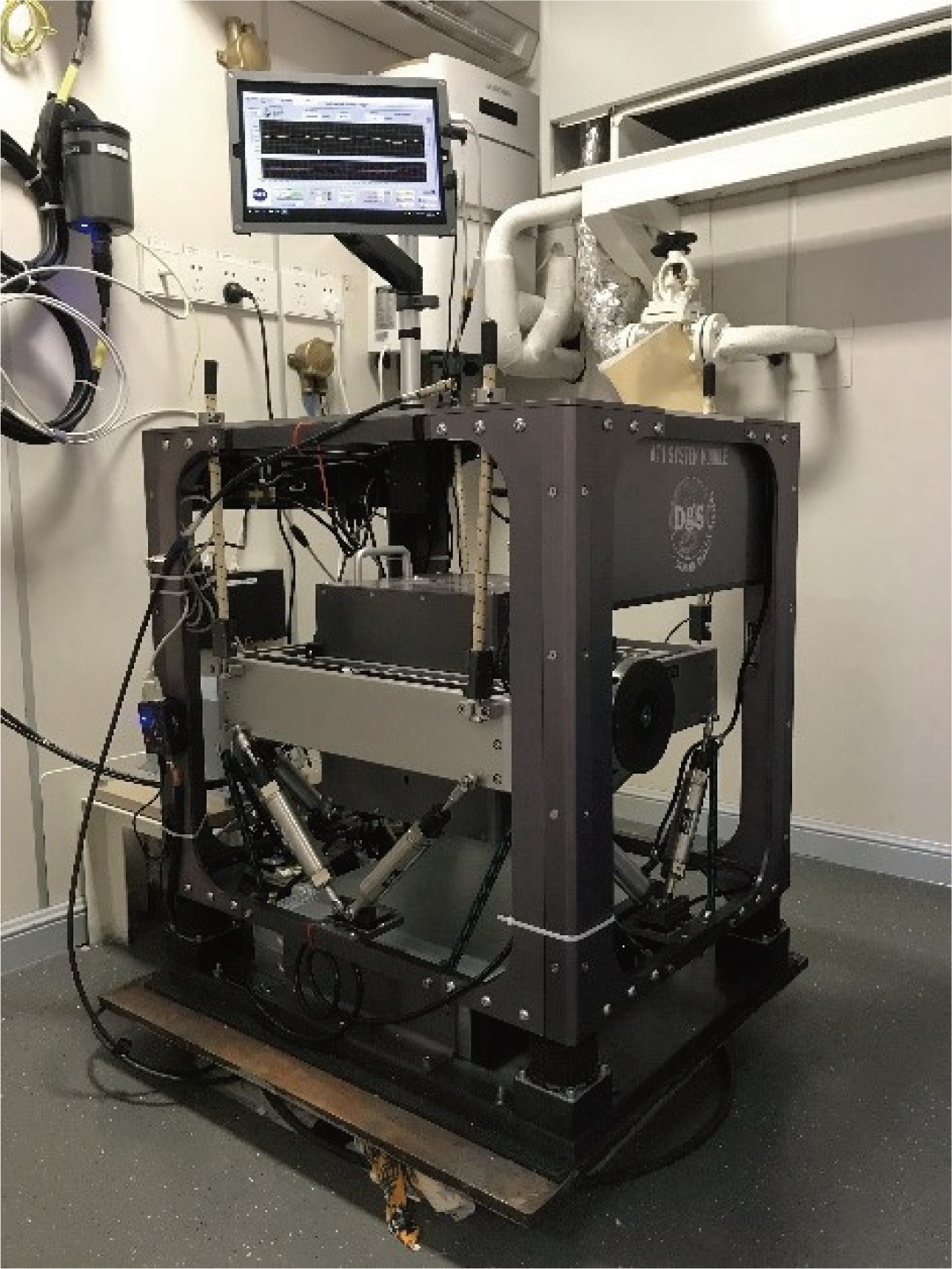
Fig. 1
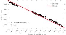
Fig. 2
Static test results of the DGS AT1M-11 gravimeter"
Fig. 2
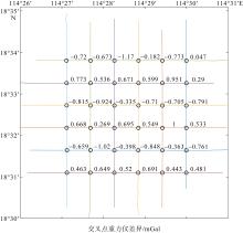
Fig. 3
Internal conformity accuracy assessment"
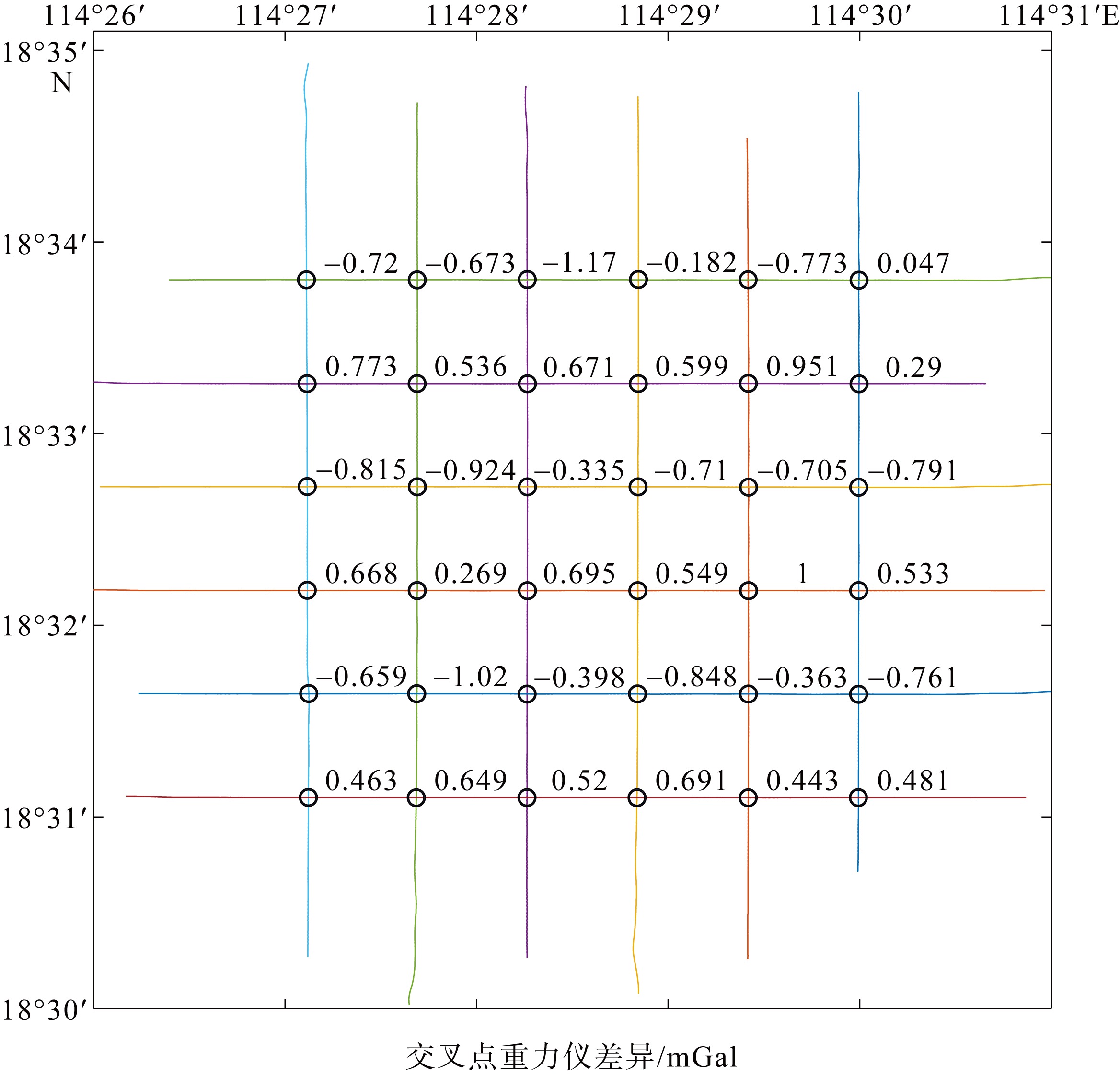
Fig. 3
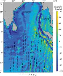
Fig. 4
Distribution of GRACE gravity anomalies in the northeastern Indian Ocean region. The transformation fault was modified from Zhu et al (2024)"

Fig. 4
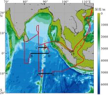
Fig. 5
Track and gravity data collection map of the 2022 Eastern Indian Ocean Shared Voyage. The A-A′, B-B′ and C-C′ profiles are the measured gravity profiles used in this paper"
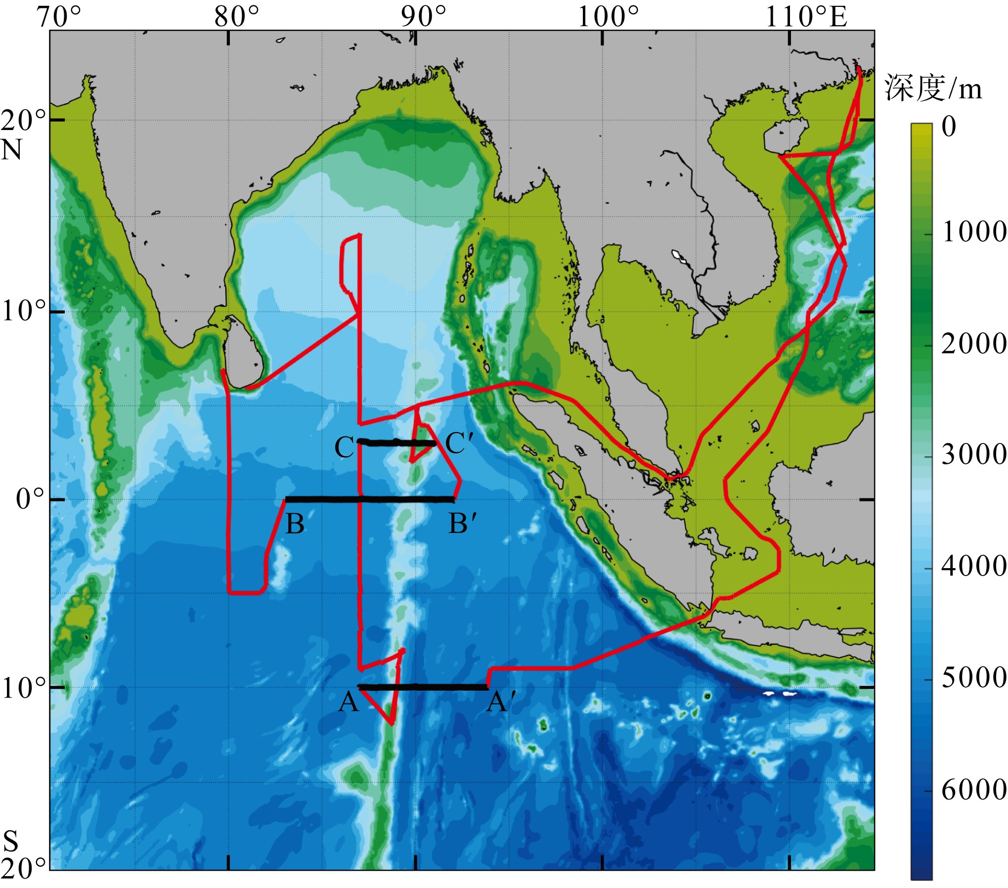
Fig. 5
Tab. 1
Pre- and post-cruise benchmark tests of the 2022 Eastern Indian Ocean Voyage"
| 日期 | 时间 | 地点 | 桥面至水面距离/m | 船舶吃水/m | 重力仪读数/mGal |
|---|---|---|---|---|---|
| 2022-03-10 | 12:40 | 南海海洋研究所新洲码头 | 2.51 | 5.6 | 10108.8 |
| 2022-05-22 | 16:14 | 南海海洋研究所新洲码头 | 1.75 | 5 | 10106.6 |
Tab. 1
Tab. 2
Gravity intersection point information from the 2022 Eastern Indian Ocean Voyage"
| 交点序号 | 经度 | 纬度 | 第一次经过 | 第二次经过 | 两次差值/mGal | ||
|---|---|---|---|---|---|---|---|
| 时间(北京) | 重力/mGal | 时间(北京) | 重力 /mGal | ||||
| 1 | 88°59′59.64″E | 9°59′50.28″S | 2022-03-25, 23:54:02 | 9467.46 | 2022-03-29, 02:59:14 | 9466.54 | −0.92 |
| 2 | 87°06′16.92″E | 0°02′37.68″N | 2022-04-05, 15:15:05 | 9300.89 | 2022-05-01, 10:20:58 | 9302.29 | −1.41 |
| 3 | 89°54′06.12″E | 2°59′54.96″N | 2022-04-08, 23:04:28 | 9336.72 | 2022-04-11, 10:02:54 | 9337.79 | 1.06 |
Tab. 2
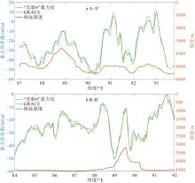
Fig. 6
Comparison between the measured profiles of A-A′ and B-B′ with the GRACE gravity field"

Fig. 6
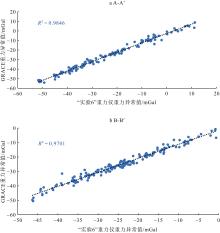
Fig. 7
Correlation analysis between measured data of the R/V “Shiyan 6” gravimeter and GRACE gravity field data"

Fig. 7
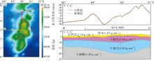
Fig. 8
Gravity modeling results of profile C-C′. (a) Schematic diagram of the geographical location of profile C-C′; (b) gravity anomalies obtained by the DGS AT1M-11 gravimeter (green) and modeled by simulation calculations (red). (c) best fitting 2-dimensional gravity model for profile C-C′, with density units in g·cm−3"
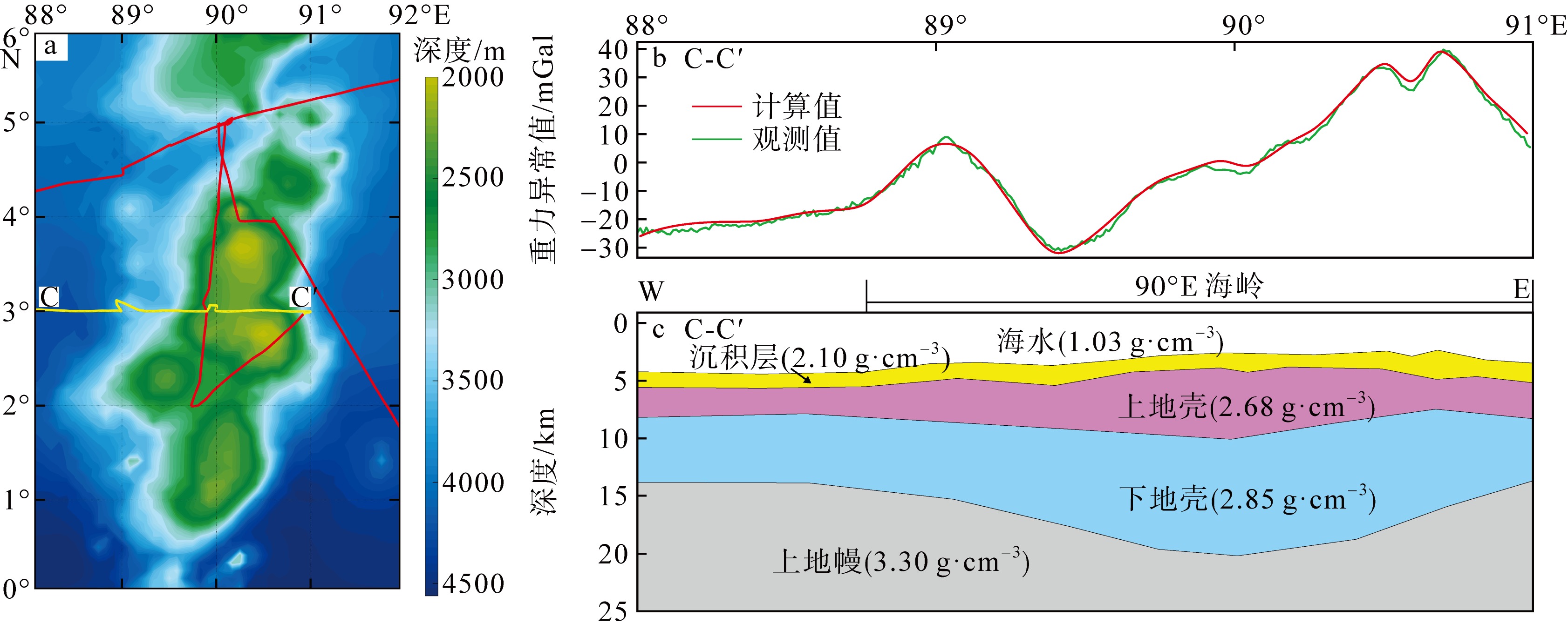
Fig. 8
| [1] |
|
| [2] |
黄谟涛, 翟国君, 管铮, 等, 2005. 海洋重力场测定及其应用[M]. 北京: 测绘出版社 (in Chinese).
|
| [3] |
黄仲良, 2008. 石油重磁电法勘探[M]. 东营: 中国石油大学出版社.
|
|
|
|
| [4] |
李锦, 成月, 魏柠阳, 2018. 海洋重力仪的研究现状[C]// 中国造船工程学会船舶力学学术委员会第九届全体会议论文集. 无锡: 中国造船工程学会 (in Chinese).
|
| [5] |
宁津生, 黄谟涛, 欧阳永忠, 等, 2014. 海空重力测量技术进展[J]. 海洋测绘, 34(3): 67-72, 76.
|
|
|
|
| [6] |
欧阳永忠, 2013. 海空重力测量数据处理关键技术研究[D]. 武汉: 武汉大学.
|
|
|
|
| [7] |
冉将军, 许厚泽, 钟敏, 等, 2014. 利用GRACE重力卫星观测数据反演全球时变地球重力场模型[J]. 地球物理学报, 57(4): 1032-1040.
|
|
|
|
| [8] |
王福民, 叶宇星, 2007. S-Ⅱ型海洋重力仪介绍和使用方法[J]. 物探装备, 17(3): 210-214.
|
| [1] |
董庆亮, 李东庆, 杨建宇, 等, 2019. 海洋重力仪更换部件时的设置与操作[J]. 海洋测绘, 39(1): 44-47.
|
| [8] |
|
| [9] |
许才军, 申文斌, 晁定波, 2006. 地球物理大地测量学原理与方法[M]. 武汉: 武汉大学出版社.
|
|
|
|
| [10] |
姚长利, 郝天珧, 管志宁, 等, 2003. 重磁遗传算法三维反演中高速计算及有效存储方法技术[J]. 地球物理学报, 46: 252-258.
|
|
|
|
| [11] |
张彬彬, 万丽丽, 2024. DGS-AT1M型海洋重力仪静态观测结果分析与评估[J]. 物探与化探, 48(4): 1018-1024.
|
|
|
|
| [12] |
张登, 袁园, 陶春辉, 等, 2020. DGS AT1M-3海洋重力仪的应用及精度评估[J]. 海洋测绘, 40(3): 68-72.
|
|
|
|
| [13] |
张遴梁, 2001. 海洋重力仪的现状和发展[J]. 海洋科学, 25(9): 18-20.
|
|
|
|
| [14] |
朱佳豪, 裴彦良, 支鹏遥, 等, 2024. 东印度洋东经90°海岭的地球物理特征和成因探讨[J]. 海洋科学进展, 42(3): 515-531.
|
|
|
|
| [15] |
曾华霖, 1999. 重力仪的现状及发展[J]. 物探与化探, 23(2): 84-89, 103.
|
|
|
|
| [16] |
曾华霖, 2005. 重力场与重力勘探[M]. 北京: 地质出版社 (in Chinese).
|
| [17] |
曾华霖, 李小孟, 1999. 重力勘探油气藏方法及其应用[M]. 北京: 地质出版社 (in Chinese).
|
| [18] |
中华人民共和国国家质量监督检验检疫总局, 中国国家标准化管理委员会, 2007. 海洋调查规范第8部分: 海洋地质地球物理调查(GB/T 12763. 8-2007)[S]. 北京: 中国标准出版社.
|
|
General Administration of Quality Supervision, Inspection and Quarantine of the People's Republic of China, Standardization Administration of the People's Republic of China, 2007. Specifications for oceanographic survey-Part 8 : Marine geology and geophysics survey(GB/T 12763. 8-2007)[S]. Beijing: Standards Press of China (in Chinese).
|
|
| [19] |
中华人民共和国自然资源部, 2020. 海洋重力测量技术规范( DZ/T 0356-2020)[S].
|
|
Ministry of Natural Resources, PRC, 2020. Technical specification for marine gravity survey (DZ/T 0356-2020) (in Chinese).
|
|
| [20] |
doi: 10.1175/2010JTECHO738.1 |
| [21] |
doi: 10.1126/science.1129007 pmid: 16902089 |
| [22] |
|
| [23] |
|
| [24] |
doi: 10.1029/JZ072i012p03015 |
| [25] |
doi: 10.1016/j.epsl.2015.06.005 |
| [26] |
doi: 10.1121/1.381747 |
| [27] |
|
| [28] |
|
| [29] |
doi: 10.1007/BF01203426 |
| [30] |
doi: 10.1093/gji/ggw162 |
| [31] |
|
| [32] |
doi: 10.1126/science.1258213 |
| [33] |
doi: 10.1130/0016-7606(1974)85<683:EOTECI>2.0.CO;2 |
| [34] |
|
| [35] |
|
| [36] |
|
| [1] | DU Shuhuan, XIANG Rong, SU Xiang, ZHANG Lanlan, PAN Zirui, XIE Jinwo, LUO Chuanxiu, WAN Sui. Calcium carbonate composition of surface sediments and influencing factors in the 90°E Ridge of the northeastern Indian Ocean* [J]. Journal of Tropical Oceanography, 2026, 45(1): 73-80. |
| [2] | ZHONG Fuchang, XIANG Rong, YANG Yiping, MAO Huabin. Distribution characteristics and influencing factors of benthic foraminifera in surface sediments of the northeast Indian Ocean Ridge region* [J]. Journal of Tropical Oceanography, 2026, 45(1): 81-90. |
| [3] | SU Xiang, XIANG Rong, ZHANG Lanlan, LUO Chuanxiu, LIU Jianguo, WAN Sui, LI Zaigui, NILUFAR Yasmin Liza. Evolution of marine primary productivity on the 90°E Ridge in the northeastern Indian Ocean since the Last Glacial Period: Insights from coccolith records⁎ [J]. Journal of Tropical Oceanography, 2026, 45(1): 131-139. |
|
||