
Journal of Tropical Oceanography ›› 2024, Vol. 43 ›› Issue (1): 137-153.doi: 10.11978/2023023CSTR: 32234.14.2023023
• Oceanographic research and observation • Previous Articles Next Articles
Remote sensing monitoring of mangrove wetland changes combined with tidal level correction in the Leizhou Peninsula
SHEN Jian1( ), JIAN Zhuokai2, OUYANG Xuemin3, AI Bin2()
- 1. Marine Development Planning Research Center of Guangdong Province, Guangzhou 510000, China
2. School of Marine Sciences, Sun Yat-sen University, Southern Marine Science and Engineering Guangdong Laboratory (Zhuhai), Zhuhai 519082, China
3. Guizhou Technological College of Machinery and Electricity, Duyun 558000, China
-
Received:2023-02-23Revised:2023-04-11Online:2024-01-10Published:2024-01-19 -
Supported by:National Natural Science Foundation of China(42071261); Innovation Group Project of Southern Marine Science and Engineering Guangdong Laboratory (Zhuhai)(311020003/311021004)
Cite this article
SHEN Jian, JIAN Zhuokai, OUYANG Xuemin, AI Bin. Remote sensing monitoring of mangrove wetland changes combined with tidal level correction in the Leizhou Peninsula[J].Journal of Tropical Oceanography, 2024, 43(1): 137-153.
share this article
Add to citation manager EndNote|Reference Manager|ProCite|BibTeX|RefWorks
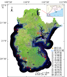
Fig. 1
Study area"

Fig. 1
Tab. 1
Remote sensing data sources and parameters"
| 年份 | 传感器型号 | 分辨率/m | 行列号 | 西区影像 | 东区影像 | ||
|---|---|---|---|---|---|---|---|
| 获取时间(GMT+8) | 云量/% | 获取时间(GMT+8) | 云量/% | ||||
| 2020年 | Landsat 8 OLI | 30 | 124/46 | 2021-12-03 11:05:38 | 0.04 | 2020-01-31 11:05:22 | 2.44 |
| Landsat 8 OLI | 30 | 124/45 | 2021-12-03 11:05:14 | 0.08 | 2020-01-31 11:04:58 | 5.43 | |
| 2015年 | Landsat 8 OLI | 30 | 124/46 | 2015-01-01 11:05:17 | 3.50 | 2016-12-05 11:05:35 | 9.32 |
| Landsat 8 OLI | 30 | 124/45 | 2015-01-01 11:04:53 | 0.10 | 2016-12-05 11:05:11 | 11.31 | |
| 2005年 | Landsat 5 TM | 30 | 124/46 | 2006-01-24 10:55:16 | 33.00 | 2004-12-04 10:50:45 | 2.00 |
| Landsat 5 TM | 30 | 124/45 | 2006-01-24 10:54:53 | 7.00 | 2004-12-04 10:50:21 | 0.00 | |
| 1995年 | Landsat 5 TM | 30 | 124/46 | 1994-01-23 10:26:32 | 1.00 | — | — |
| Landsat 5 TM | 30 | 124/45 | 1994-01-23 10:26:09 | 0.00 | — | — | |
Tab. 1
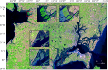
Fig. 2
Variations of tide levels in different regions. (a), (b), (d) are images of January 31, 2020, and (c), (e) are local area maps corresponding to December 3, 2021"

Fig. 2
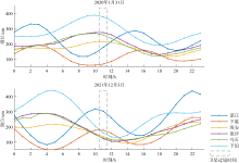
Fig. 3
Tidal station data for sensor transit times"
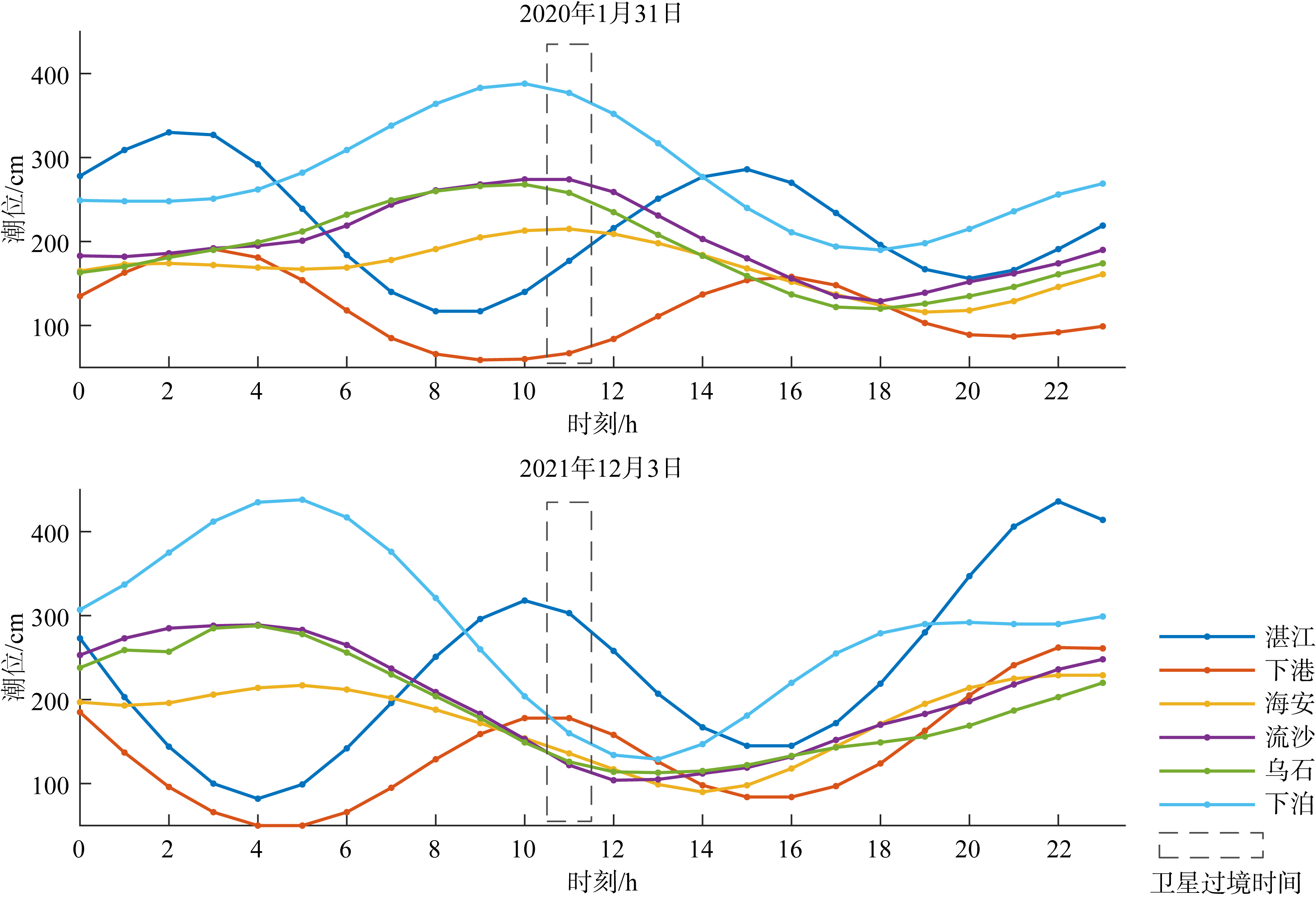
Fig. 3
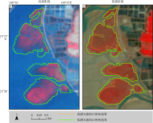
Fig. 4
Partially submerged mangroves at the high tide of the Anpu Harbor in 2005"

Fig. 4
Tab. 2
Validation samples for each study year"
| 年份 | 红树林样本数 | 其他地类样本数 | 样本总数 |
|---|---|---|---|
| 1995年 | 206 | 1194 | 1400 |
| 2005年 | 257 | 1264 | 1521 |
| 2015年 | 281 | 1182 | 1463 |
| 2020年 | 364 | 1162 | 1526 |
Tab. 2
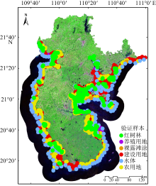
Fig. 5
Spatial distribution of validation samples in 2020"

Fig. 5
Tab. 3
Accuracy statistics of mangrove post-processing data"
| 年份 | 总体精度 | Kappa系数 |
|---|---|---|
| 1995年 | 99.79% | 0.9913 |
| 2005年 | 98.95% | 0.9642 |
| 2015年 | 99.45% | 0.9624 |
| 2020年 | 99.15% | 0.9766 |
Tab. 3
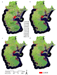
Fig. 6
Mangrove distribution in the Leizhou Peninsula, (a) 1995; (b) 2005; (c) 2015; (d) 2020"

Fig. 6

Fig. 7
Frequency distribution of partial mangrove occurrence in the Leizhou Peninsula from 1995 to 2020"

Fig. 7
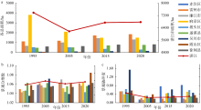
Fig. 8
Changes of mangroves in the Zhanjiang City and its counties (a) changes in area; (b) changes in landscape fractal dimensions; (c) changes in landscape fragmentation"

Fig. 8
Tab. S1
Statistical table of mangrove landscape changes in the Zhanjiang City and its counties"
| 区域 | 红树林面积/hm² | 景观分维数 | 景观破碎度 | |||||||||
|---|---|---|---|---|---|---|---|---|---|---|---|---|
| 1995 | 2005 | 2015 | 2020 | 1995 | 2005 | 2015 | 2020 | 1995 | 2005 | 2015 | 2020 | |
| 赤坎区- | 0 | 6.75 | 2.61 | 2.42 | — | 1.0587 | 1.0203 | 1.0203 | — | 0.15 | 0.77 | 0.83 |
| 雷州市+ | 1124.45 | 1192.60 | 1730.67 | 1853.19 | 1.0494 | 1.0623 | 1.0635 | 1.0619 | 0.53 | 0.22 | 0.19 | 0.20 |
| 廉江市 | 682.39 | 1018.62 | 1454.71 | 1321.50 | 1.0427 | 1.0573 | 1.0703 | 1.0567 | 0.53 | 0.13 | 0.09 | 0.15 |
| 麻章区 | 3817.56 | 2107.74 | 1496.73 | 1501.53 | 1.0454 | 1.0529 | 1.0512 | 1.0633 | 0.39 | 0.32 | 0.43 | 0.51 |
| 坡头区- | 532.55 | 526.19 | 369.22 | 305.20 | 1.0463 | 1.0525 | 1.0432 | 1.0429 | 0.64 | 0.33 | 0.46 | 0.59 |
| 遂溪县+ | 480.55 | 517.61 | 719.84 | 775.43 | 1.0629 | 1.0625 | 1.0556 | 1.0560 | 0.47 | 0.20 | 0.25 | 0.30 |
| 吴川市+ | 74.06 | 110.67 | 136.60 | 161.88 | 1.0349 | 1.0720 | 1.0389 | 1.0583 | 1.54 | 0.23 | 0.62 | 0.46 |
| 霞山区- | 62.71 | 45.97 | 30.25 | 28.04 | 1.0579 | 1.0548 | 1.0626 | 1.0848 | 0.57 | 0.39 | 0.33 | 0.36 |
| 徐闻县+ | 610.96 | 647.09 | 799.29 | 824.20 | 1.0476 | 1.0561 | 1.0541 | 1.0628 | 0.33 | 0.18 | 0.23 | 0.23 |
| 湛江市 | 7385.21 | 6173.23 | 6739.92 | 6773.39 | 1.0484 | 1.0588 | 1.0511 | 1.0563 | 0.45 | 0.24 | 0.25 | 0.29 |
Tab. S1

Fig. 9
Distribution of mangrove changes in the Leizhou Peninsula from 1995 to 2005"

Fig. 9
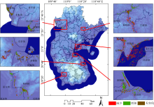
Fig. 10
Distribution of mangrove changes in the Leizhou Peninsula from 2005 to 2015"

Fig. 10

Fig. 11
Distribution of mangrove changes in the Leizhou Peninsula from 2015 to 2020"
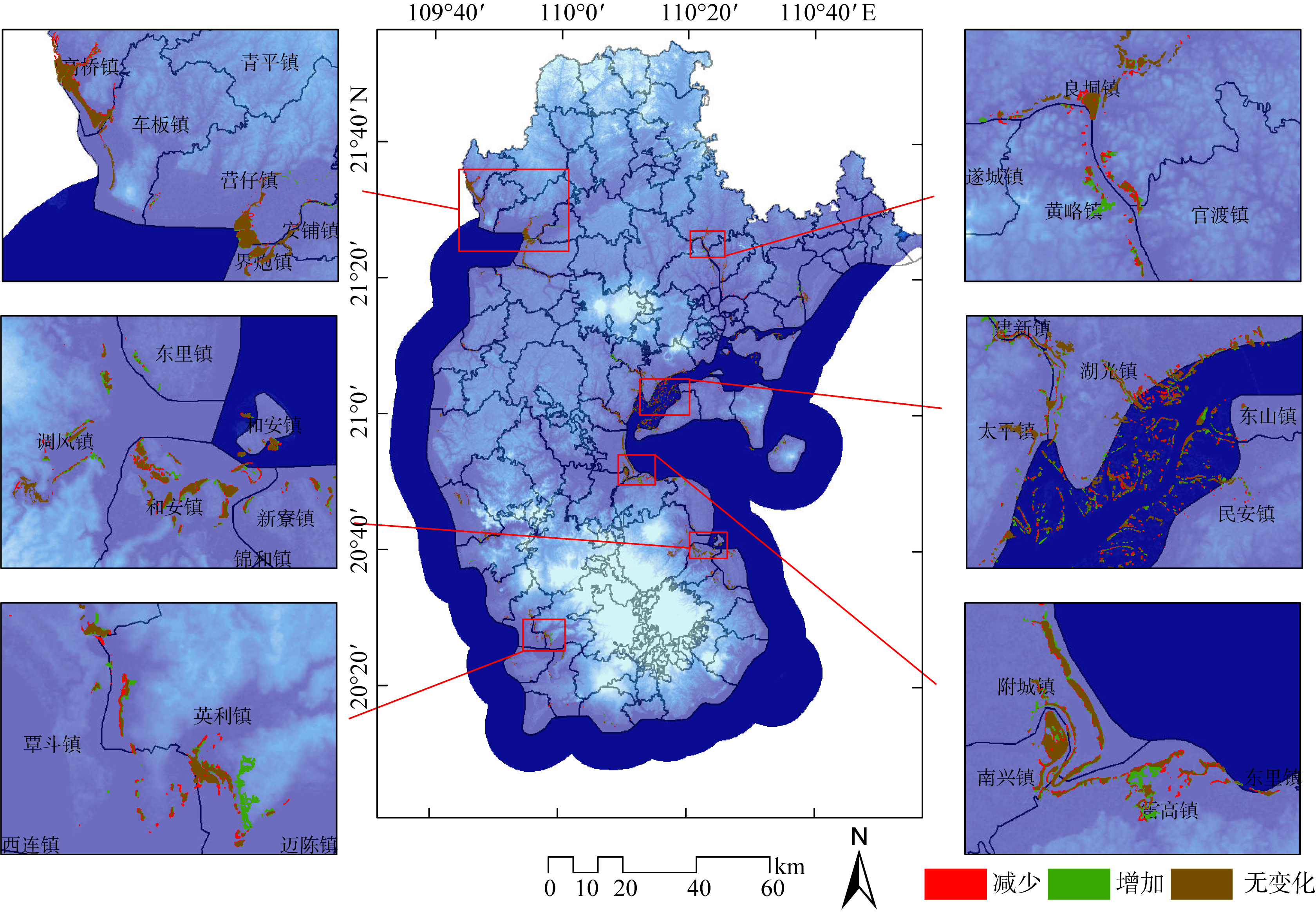
Fig. 11

Fig. 12
Dynamics of mangrove loss in the Zhanjiang City from 1995 to 2020"
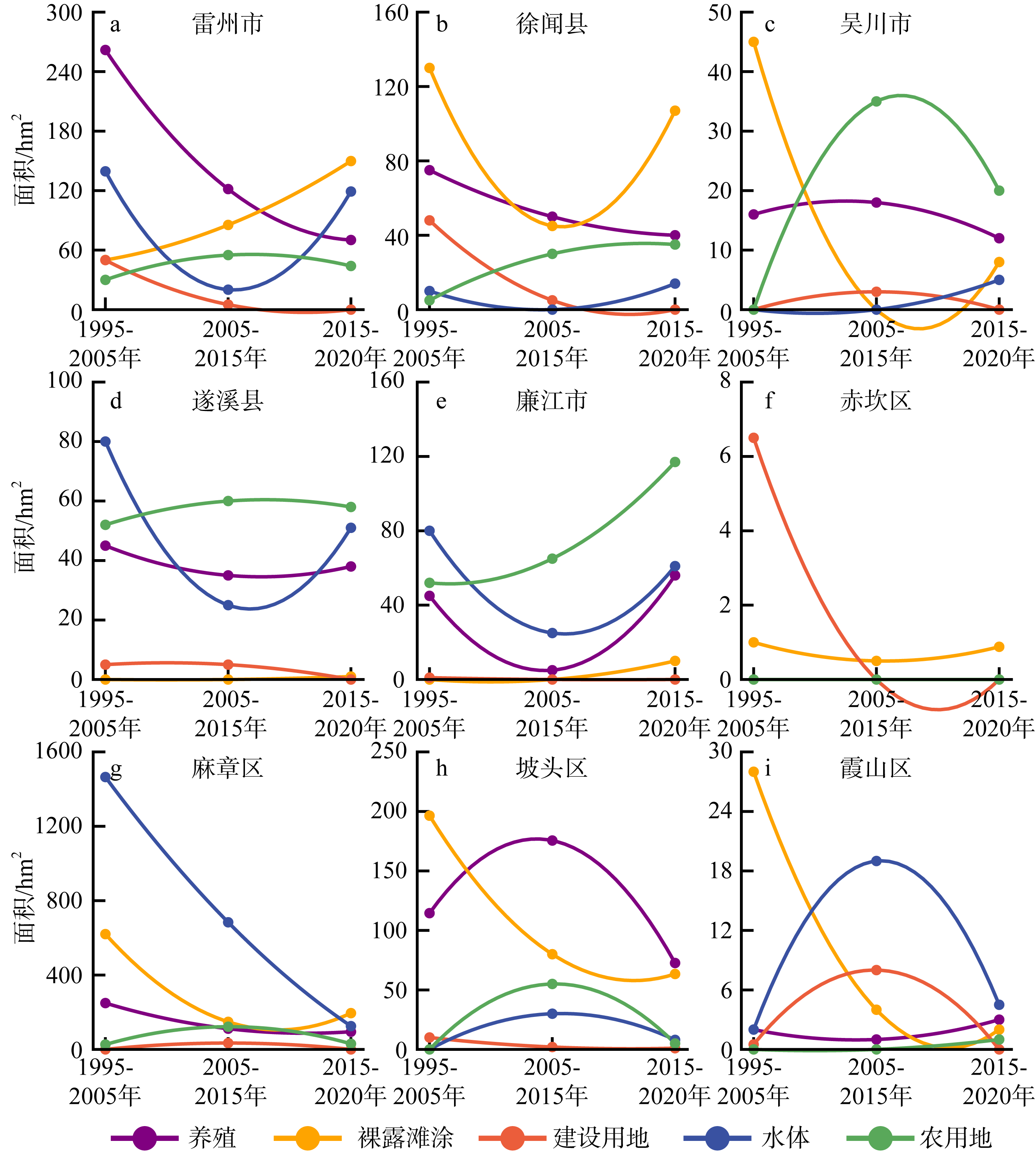
Fig. 12
Fig. 13
Dynamics of mangrove increase in the Zhanjiang City from 1995 to 2020"
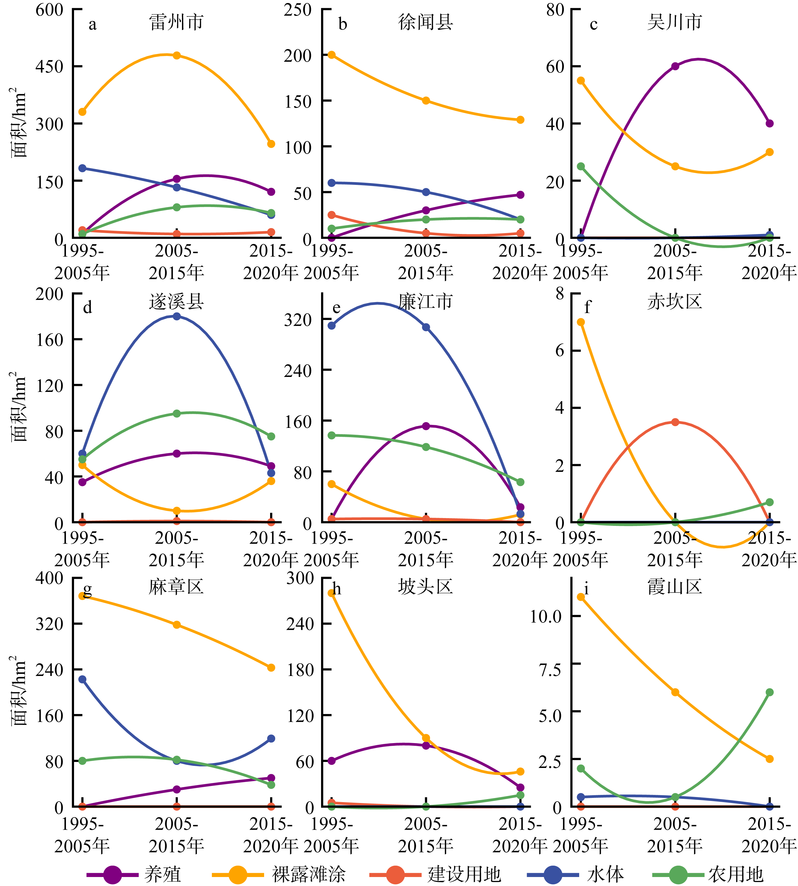
Fig. 13
Tab. S2
Area conversion between mangrove and other land cover types in the Mazhang District from 1995 to 2020"
| 主要景观类型 | 1995—2005年 红树林面积/hm² | 2005—2015年 红树林面积/hm² | 2015—2020年 红树林面积/hm² | |||
|---|---|---|---|---|---|---|
| 转入 | 转出 | 转入 | 转出 | 转入 | 转出 | |
| 养殖 | — | 249.23 | 30.03 | 111.41 | 49.98 | 95.05 |
| 裸露滩涂 | 368.33 | 620.10 | 318.01 | 148.21 | 243.00 | 195.15 |
| 建设用地 | — | — | — | 34.21 | — | — |
| 水体 | 222.57 | 1464.99 | 79.92 | 683.73 | 119.16 | 125.20 |
| 农用地 | 80.04 | 26.27 | 81.94 | 125.20 | 38.02 | 30.16 |
| 总计 | 670.74 | 2360.59 | 509.9 | 1102.76 | 450.16 | 445.56 |
Tab. S2
Tab. S3
Area conversion between mangrove and other land cover types in the Leizhou City from 1995 to 2020"
| 主要景观类型 | 1995—2005年 红树林面积/hm² | 2005—2015年 红树林面积/hm² | 2015—2020年 红树林面积/hm² | |||
|---|---|---|---|---|---|---|
| 转入 | 转出 | 转入 | 转出 | 转入 | 转出 | |
| 养殖 | 10.02 | 261.84 | 154.57 | 121.57 | 120.65 | 70.21 |
| 裸露滩涂 | 330.40 | 50.06 | 478.31 | 85.40 | 246.31 | 149.83 |
| 建设用地 | 20.04 | 49.95 | 9.98 | 5.05 | 14.98 | — |
| 水体 | 182.57 | 139.45 | 132.2 | 20.10 | 60.00 | 119.10 |
| 农用地 | 10.09 | 30.00 | 79.94 | 55.02 | 65.12 | 44.01 |
| 总计 | 553.12 | 531.30 | 855.00 | 287.14 | 507.06 | 383.18 |
Tab. S3
Tab. S4
Area conversion between mangrove and other land cover types in the Potou District from 1995 to 2020"
| 主要景观类型 | 1995—2005年 红树林面积/hm² | 2005—2015年 红树林面积/hm² | 2015—2020年 红树林面积/hm² | |||
|---|---|---|---|---|---|---|
| 转入 | 转出 | 转入 | 转出 | 转入 | 转出 | |
| 养殖 | 60.14 | 114.51 | 79.87 | 175.55 | 25.03 | 72.61 |
| 裸露滩涂 | 280.07 | 196.42 | 90.11 | 80.00 | 45.87 | 63.39 |
| 建设用地 | 5.02 | 10.02 | — | 1.98 | — | 1.03 |
| 水体 | — | — | — | 29.86 | — | 8.13 |
| 农用地 | — | — | — | 55.14 | 14.92 | 4.89 |
| 总计 | 345.23 | 320.95 | 169.98 | 342.53 | 85.82 | 150.05 |
Tab. S4
Tab. S5
Area conversion between mangrove and other land cover types in the Lianjiang City from 1995 to 2020"
| 主要景观类 | 1995—2005年 红树林面积/hm² | 2005—2015年 红树林面积/hm² | 2015—2020年 红树林面积/hm² | |||
|---|---|---|---|---|---|---|
| 转入 | 转出 | 转入 | 转出 | 转入 | 转出 | |
| 养殖 | 5.12 | 45.24 | 151.22 | 4.96 | 23.59 | 56.11 |
| 裸露滩涂 | 60.01 | — | 5.22 | — | 11.76 | 9.88 |
| 建设用地 | 4.68 | 1.14 | 5.26 | — | — | — |
| 水体 | 309.40 | 80.21 | 306.91 | 24.82 | 13.00 | 61.03 |
| 农用地 | 136.64 | 51.74 | 118.39 | 65.13 | 63.14 | 117.06 |
| 总计 | 515.85 | 178.33 | 587.00 | 94.91 | 113.49 | 244.08 |
Tab. S5
| [1] |
曹林, 韩维栋, 李凤凤, 等, 2010. 雷州湾红树湿地景观格局演变及驱动力分析[J]. 林业科技开发, 24(4): 18-23.
|
|
|
|
| [2] |
陈云, 戴锦芳, 李俊杰, 2008. 基于影像多种特征的CART决策树分类方法及其应用[J]. 地理与地理信息科学, 24(2): 33-36.
|
|
|
|
| [3] |
但新球, 廖宝文, 吴照柏, 等, 2016. 中国红树林湿地资源、保护现状和主要威胁[J]. 生态环境学报, 25(7): 1237-1243.
doi: 10.16258/j.cnki.1674-5906.2016.07.021 |
|
|
|
| [4] |
韩维栋, 高秀梅, 1998. 湛江红树林的保护策略[J]. 广东林业科技, (3): 18-22.
|
|
|
|
| [5] |
何洪钜, 1987. 华南沿海潮汐基本特征[J]. 热带海洋学报, 6(2): 39-47.
|
|
|
|
| [6] |
何闪闪, 孙羽, 2022. 绿肺焕发生机蓝碳凸显价值——广东湛江吹响建设”红树林之城”号角[J]. 环境, (2): 55-56 (in Chinese).
|
| [7] |
黄桂林, 1996. 中国红树林湿地的保护与发展[J]. 林业资源管理, (5): 15-18 (in Chinese).
|
| [8] |
贾明明, 2014. 1973-2013年中国红树林动态变化遥感分析[D]. 长春: 中国科学院研究生院(东北地理与农业生态研究所).
|
|
|
|
| [9] |
姜刘志, 杨道运, 梅立永, 等, 2018. 深圳市红树植物群落碳储量的遥感估算研究[J]. 湿地科学, 16(5): 618-625.
|
|
|
|
| [10] |
李春干, 代华兵, 2014. 红树林空间分布信息遥感提取方法[J]. 湿地科学, 12(5): 580-589.
|
|
|
|
| [11] |
廖宝文, 张乔民, 2014. 中国红树林的分布、面积和树种组成[J]. 湿地科学, 12(4): 435-440.
|
|
|
|
| [12] |
林鹏, 1997. 中国红树林生态系[M]. 北京: 科学出版社.
|
|
|
|
| [13] |
林鹏, 傅勤, 1995. 中国红树林环境生态及经济利用[M]. 北京: 高等教育出版社.
|
|
|
|
| [14] |
孟佩, 2015. 广东湛江红树林国家级自然保护区功能区调整与评价研究[D]. 长沙: 中南林业科技大学.
|
|
|
|
| [15] |
彭逸生, 周炎武, 陈桂珠, 2008. 红树林湿地恢复研究进展[J]. 生态学报, 28(2): 786-797.
|
|
|
|
| [16] |
石莉, 2002. 中国红树林的分布状况、生长环境及其环境适应性[J]. 海洋信息技术与应用, (4): 14-18.
|
|
|
|
| [17] |
唐道斌, 辛存林, 陈宁, 等, 2022. 2000—2018年湛江通明海红树林破碎化及生态服务价值[J]. 应用生态学报, 34(2): 415-422.
|
|
|
|
| [18] |
吴中亨, 蔡俊欣, 叶亲柏, 2000. 无瓣海桑引种及推广效果分析[J]. 广东林业科技, (2): 6-10.
|
|
|
|
| [19] |
徐芳, 2020. 基于Sentinel-2的红树林提取及碳储量估算研究[D]. 兰州: 兰州交通大学.
|
|
|
|
| [20] |
杨彩福, 焦学志, 2008. 近50年来湛江市年极端气温统计分析[J]. 广东气象, 30(3): 14-16.
|
|
|
|
| [21] |
杨新华, 2001. 湛江市的干旱状况及水资源的可持续利用[J]. 华中农业大学学报(社会科学版), (4): 19-23.
|
|
|
|
| [22] |
于航, 刘学录, 赵天明, 等, 2022. 基于景观格局的祁连山国家公园景观生态风险评价[J]. 生态科学, 41(2): 99-107.
|
|
|
|
| [23] |
郁林, 党星海, 纪婵, 等, 2021. 珠海市湿地景观格局演变及其驱动力分析[J]. 地理空间信息, 19(11): 48-53+7.
|
|
|
|
| [24] |
湛江市人民政府, (2023-04-14), [2023-04-26]. 湛江概况[EB-OL]. https://www.zhanjiang.gov.cn-mlzj-zjgk-content-post1300793.html
|
| [25] |
张乔民, 于红兵, 陈欣树, 等, 1997. 红树林生长带与潮汐水位关系的研究[J]. 生态学报, 17(3): 258-265.
|
|
|
|
| [26] |
张苇, 林广旋, 刘一鸣, 2011. 湛江红树林国家级自然保护区人工造林现状及造林技术探讨[J]. 湿地科学与管理, 7(1): 37-39.
|
|
|
|
| [27] |
张希然, 罗旋, 1987. 湛江港和雷州湾海涂土壤特性[J]. 热带地理, 7(2): 128-136.
|
|
|
|
| [28] |
张雪红, 葛州徽, 甄晓菊, 等, 2022. 结合潮位与DEM的红树林遥感识别研究[J/OL], 南京信息工程大学学报(自然科学版), 1-12.
|
|
|
|
| [29] |
张雪红, 周杰, 魏瑗瑗, 等, 2013. 结合潮位信息的红树林遥感识别[J]. 南京信息工程大学学报(自然科学版), 5(6): 501-507.
|
|
|
|
| [30] |
|
| [31] |
doi: 10.3390/rs10010089 |
| [32] |
doi: 10.1016/j.isprsjprs.2017.07.011 |
| [33] |
doi: 10.1080/014311698215045 |
| [34] |
doi: 10.1111/geb.2011.20.issue-1 |
| [35] |
doi: 10.1016/j.ecss.2006.12.019 |
| [36] |
doi: 10.1111/jbi.2008.35.issue-3 |
| [37] |
doi: 10.1016/j.jag.2018.04.001 |
| [38] |
doi: 10.1016/j.ecoleng.2004.10.003 |
| [39] |
doi: 10.1109/JSTARS.4609443 |
| [40] |
doi: 10.3390/rs10020294 |
| [41] |
doi: 10.1016/j.ecolind.2021.108415 |
| [42] |
|
| [43] |
doi: 10.1016/j.jag.2022.102918 |
| [44] |
doi: 10.1016/j.isprsjprs.2020.10.001 |
| [45] |
doi: 10.1002/gdj3.v9.1 |
| [1] | AN Fan, JIANG Yue, WANG Yu, CAO Guangping, GAO Chenghai, LIU Yonghong, YI Xiangxi, BAI Meng. Studies on secondary metabolites of endophytic fungus Aspergillus terreus GXIMD 03158 isolated from mangroves Acanthus ilicifolius L. [J]. Journal of Tropical Oceanography, 2024, 43(5): 41-48. |
| [2] | WU Hongbo, LUO Feng, CHEN Zhipeng, ZHU Fei, ZENG Jingwei, ZHANG Chi, LI Ruijie. A novel pattern for predicting the effects of mangrove ecological reconstruction [J]. Journal of Tropical Oceanography, 2024, 43(4): 86-97. |
| [3] | ZHENG Fa, HUANG Fulin, CHEN Zeheng, DING Weipin. Mangrove wetland dynamics in Shankou, Guangxi based on LUCC and landscape pattern change [J]. Journal of Tropical Oceanography, 2024, 43(4): 165-173. |
| [4] | ZHOU Zhigang, YUE Wen, LI Huiquan, LIN Yangyang. Influence of tree species and intertidal elevations on the carbon storage of the Gaoqiao mangrove area in Zhanjiang, Guangdong Province [J]. Journal of Tropical Oceanography, 2024, 43(2): 108-120. |
| [5] | GENG Wanlu, XING Yongze, ZHANG Qiufeng, GUAN Weibing. Structural characteristics of macrobenthic communities at intertidal zone for mangrove in Beihai, Guangxi [J]. Journal of Tropical Oceanography, 2024, 43(1): 107-115. |
| [6] | DONG Junde, HUANG Xiaofang, LONG Aimin, WANG Youshao, LING Juan, YANG Qingsong. Progress on the nitrogen-fixing microorganisms and their ecological functions in mangroves [J]. Journal of Tropical Oceanography, 2023, 42(4): 1-11. |
| [7] | LIANG Hanqiao, CHEN Wenfeng, FAN Yikai, ZHU Zidong, MA Guoxu, CHEN Deli, TIAN Jing. Research progress on the secondary metabolites and activities of endophytic fungi of genus Aspergillus and Trichoderma from mangroves [J]. Journal of Tropical Oceanography, 2023, 42(4): 12-24. |
| [8] | QIU Jin, DAI Hongtao, XING Yongze, HUANG Daji, Yin Qunjian, CHENG Dewei. Leaves, stems and roots stoichiometry characteristics of mangrove plants at different succession stages in the Shankou National Mangrove Nature Reserve, China* [J]. Journal of Tropical Oceanography, 2023, 42(3): 149-157. |
| [9] | ZHANG Chengfei, REN Guangbo, WU Peiqiang, HU Yabin, MA Yi, YAN Yu, ZHANG Jingrui. Mangrove species classification in the Hainan Bamen Bay based on GF optics and fully polarimetric SAR [J]. Journal of Tropical Oceanography, 2023, 42(2): 153-168. |
| [10] | YE Jincheng, CHEN Yiqing, GAO Lin, ZHOU Xianjiao, ZHONG Cairong, ZHANG Ying, WANG Yun. Analysis of rhizosphere bacterial community characteristics of mangrove plant Sonneratia × gulngai and its parents [J]. Journal of Tropical Oceanography, 2022, 41(6): 75-89. |
| [11] | SU Boyu, ZHANG Weishi, WANG Youshao. Response of antioxidant enzyme systems in root tissues of three mangrove species to waterlogging stress [J]. Journal of Tropical Oceanography, 2022, 41(6): 35-43. |
| [12] | INYANG Aniefiok Ini, ZHOU Yueyue, WANG Youshao. Characteristics of water quality and their eutrophication assessment on the mangrove ecosystems along the Guangdong coast [J]. Journal of Tropical Oceanography, 2022, 41(6): 1-11. |
| [13] | WU Weizhi, ZHAO Zhixia, YANG Sheng, LIANG Licheng, Chen Qiuxia, LU Xiang, LIU Xing, ZHANG Xiaowei. The mangrove forest distribution and analysis of afforestation effect in Zhejiang Province [J]. Journal of Tropical Oceanography, 2022, 41(6): 67-74. |
| [14] | HAO Lulu, KE Mingsi, ZHU Yixiu, XU Yanmin, ZHANG Ying, ZHENG Chunfang. Expression of DEAD-box RNA helicase enzyme genes in Lumnitzera littorea under low temperature stress [J]. Journal of Tropical Oceanography, 2022, 41(6): 44-55. |
| [15] | XIE Yong, WANG Youshao. Physiological response characteristics of four mangrove plants seedlings to heavy metal stress [J]. Journal of Tropical Oceanography, 2022, 41(6): 28-34. |
|
||