

Journal of Tropical Oceanography ›› 2026, Vol. 45 ›› Issue (4): 77-88.doi: 10.11978/2025235CSTR: 32234.14.2025235
• Ocean Remote Sensing • Previous Articles Next Articles
Spatiotemporal dynamics of mangroves at the Pinglu Canal estuary based on Sentinel-2
LIANG Xixing1,2,3( ), DAI Zhijun3(), LI Yan1, LI Shushi2, LI Weihua3, WANG Riming2, WU Erjiang1
- 1
Guangxi Academy of Oceanography
2Guangxi Key Laboratory of Marine Environmental Disaster Processes and Ecological Protection Technology ,Beibu Gulf University
3State Key Laboratory of Estuarine and Coastal Research ,East China Normal University
-
Received:2025-12-08Revised:2025-12-26Online:2026-07-10Published:2026-07-31 -
Contact:DAI Zhijun. email: zjdai@sklec.ecnu.edu.cn -
Supported by:Key Special Project for International Cooperation in Science and Technology under the National Key Research and Development Program of China(2023YFE0121200); Shanghai International Science and Technology Cooperation Fund Project(23230713800); National Natural Science Foundation of China(42366008); Key Research Topics for the Guangxi Science and Technology Community in 2025(Gui Kexie〔2025〕J-004)

CLC Number:
- P714
Cite this article
LIANG Xixing, DAI Zhijun, LI Yan, LI Shushi, LI Weihua, WANG Riming, WU Erjiang. Spatiotemporal dynamics of mangroves at the Pinglu Canal estuary based on Sentinel-2[J].Journal of Tropical Oceanography, 2026, 45(4): 77-88.
share this article
Add to citation manager EndNote|Reference Manager|ProCite|BibTeX|RefWorks
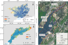
Fig. 1
Overview of the study area. (a) Geographical location of the study area in Guangxi; (b) Qinjiang River Basin; (c) extent of the study area and distribution of cross-sections used for extracting mangrove shoreline change characteristics"

Fig. 1
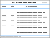
Tab. 1
Remote sensing imagery information and corresponding tidal levels"
| 序号 | 成像日期 | 卫星 | 潮位/m | 地面分辨率/m |
|---|---|---|---|---|
| 1 | 2016-04-16 | Sentinel-2 MSI | 0.96 | 10 |
| 2 | 2017-04-01 | Sentinel-2 MSI | 2.39 | 10 |
| 3 | 2018-12-17 | Sentinel-2 MSI | 2.17 | 10 |
| 4 | 2019-09-13 | Sentinel-2 MSI | 2.11 | 10 |
| 5 | 2020-11-26 | Sentinel-2 MSI | 2.21 | 10 |
| 6 | 2021-10-07 | Sentinel-2 MSI | 1.70 | 10 |
| 7 | 2022-12-21 | Sentinel-2 MSI | 1.52 | 10 |
| 8 | 2023-11-26 | Sentinel-2 MSI | 1.96 | 10 |
| 9 | 2024-11-30 | Sentinel-2 MSI | 2.13 | 10 |
| 10 | 2025-07-28 | Sentinel-2 MSI | 1.57 | 10 |
Tab. 1
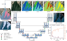
Fig. 2
Architecture of mangrove extraction based on the U-Net model and model training accuracy"

Fig. 2
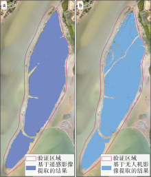
Fig. 3
Accuracy validation of mangrove extraction. (a) Mangroves extracted from Sentinel-2 imagery using the trained model (satellite passage date: December 21, 2022); (b) mangroves extracted from unmanned aerial vehicle imagery using the trained model (survey date: August 16, 2022)"

Fig. 3
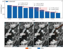
Fig. 4
Spatiotemporal dynamics of mangroves at the Pinglu Canal estuary. (a) Changes in mangrove area over time; (b-e) spatial distribution of mangrove gains and losses"

Fig. 4
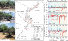
Fig. 5
Overall shoreline change trends of mangroves in the study area. (a) Spatial distribution of mangrove shoreline end point rates from 2016 to 2025; (b-d) change characteristics of mangrove shoreline for the periods 2016-2021, 2021-2023, and 2023-2025"

Fig. 5
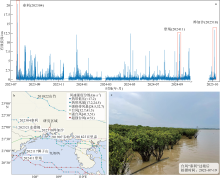
Fig. 6
Wave conditions and typhoon impacts in the study area. (a) Temporal variation of significant wave height at the outlet of the Pinglu Canal from July 2023 to October 2025; (b) typhoon tracks and intensities affecting the study area during 2016-2025; (c) mangrove conditions in the study area after the passage of typhoon Talim (202304)"
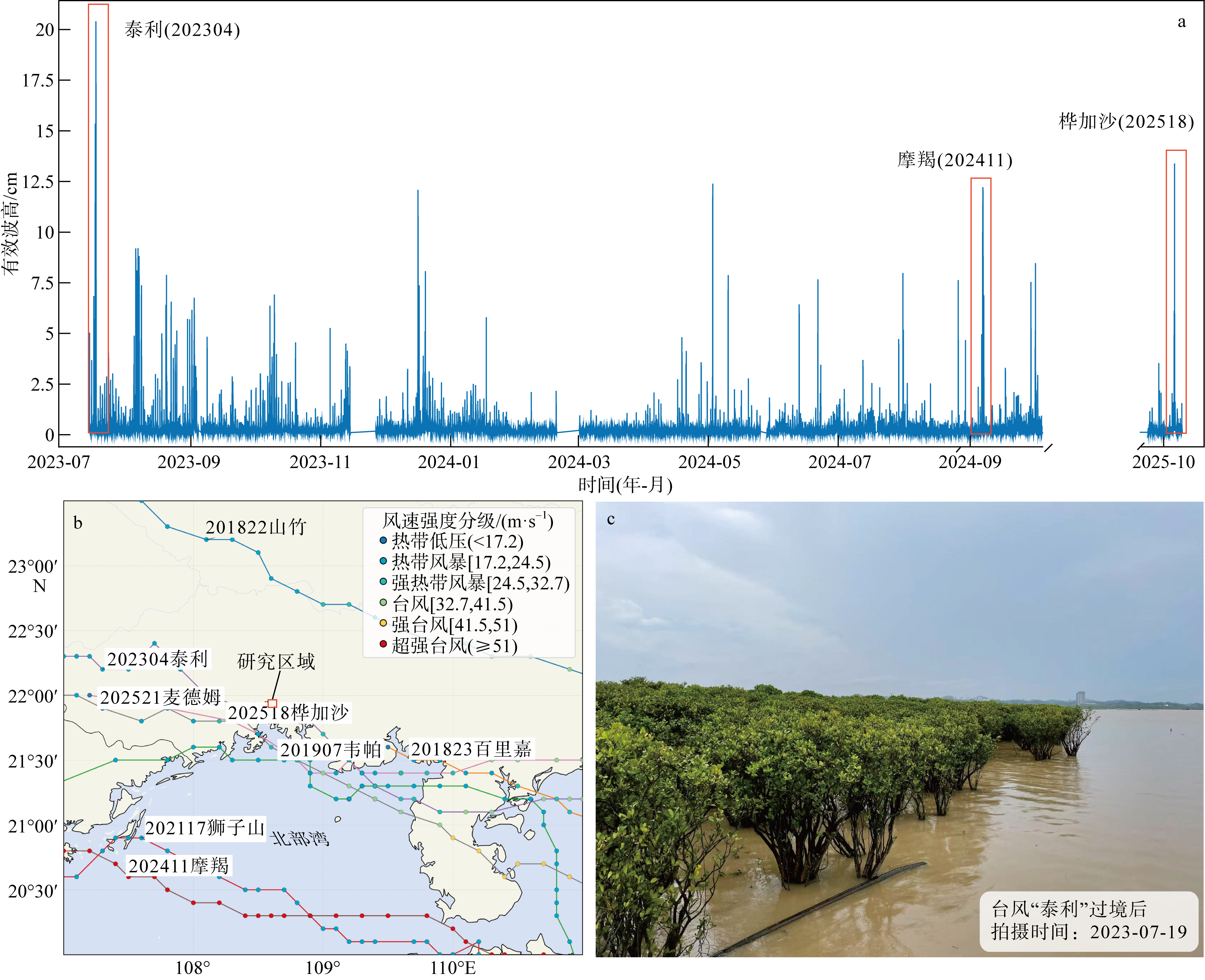
Fig. 6
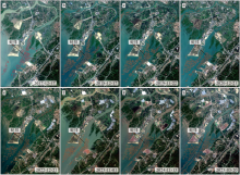
Fig. 7
Spatiotemporal distribution characteristics of oyster rafts at the Pinglu Canal estuary a. 2017-12-17; b. 2018-12-17; c. 2019-11-22; d. 2020-12-21; e. 2022-12-21; f. 2023-11-01; g. 2024-11-15; h. 2025-03-20"

Fig. 7
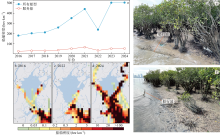
Fig. 8
Change trends in vessel density at the Pinglu Canal estuary. (a) Density variations of all vessel types and service vessels at the Pinglu Canal estuary; (b-d) spatial distribution of vessel density; (e-f) waves generated by vessel navigation"

Fig. 8
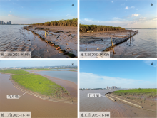
Fig. 9
Comparison before (a-b) and after (c-d) the implementation of the bamboo-fence wave-dissipation and silt-promoting project"

Fig. 9
| [1] |
戴志军, 周晓妍, 王杰, 等, 2021. 红树林潮滩沉积动力研究进展与展望[J]. 热带海洋学报, 40(3): 69-75.
doi: 10.11978/YG2020007 |
|
doi: 10.11978/YG2020007 |
|
| [2] |
冯炳斌, 王日明, 黎树式, 等, 2022. 钦州湾人工海滩剖面变化过程[J]. 热带海洋学报, 41(4): 51-60.
doi: 10.11978/2021096 |
|
doi: 10.11978/2021096 |
|
| [3] |
黄星, 辛琨, 李秀珍, 等, 2015. 基于斑块的东寨港红树林湿地景观格局变化及其驱动力[J]. 应用生态学报, 26(5):1510-1518.
pmid: 26571672 |
|
pmid: 26571672 |
|
| [4] |
黄雪松, 陈燕丽, 莫伟华, 等, 2021. 近60年广西北部湾红树林生态区气候变化及其影响因素[J]. 生态学报, 41(12): 5026-5033.
|
|
|
|
| [5] |
黎广钊, 梁文, 刘敬合, 2001. 钦州湾水下动力地貌特征[J]. 地理学与国土研究, (4): 70-75.
|
|
|
|
| [6] |
李树华, 方龙驹, 1989. 钦州湾潮汐和潮流的变化特征[J]. 海岸工程, 8(3): 39-45.
|
|
|
|
| [7] |
梁喜幸, 王日明, 戴志军, 等, 2023. 茅尾海钦江河口光滩时空变化过程研究[J]. 海洋地质与第四纪地质, 43(3): 107-118.
|
|
|
|
| [8] |
潘炜杰, 祝振昌, 蔡宴朋, 等, 2021. 潮滩冲淤扰动下外来与乡土红树植物幼苗稳定性差异[J]. 热带海洋学报, 40(6): 120-127.
doi: 10.11978/2020133 |
|
doi: 10.11978/2020133 |
|
| [9] |
任叙合, 何帅, 李保石, 2016. 茅尾海生态修复工程对冲淤影响的数值模拟研究[J]. 海洋湖沼通报, 38(6): 20-28.
|
|
|
|
| [10] |
王日明, 梁喜幸, 周晓妍, 等, 2022. 钦江河口潮滩红树林群落空间分布[J]. 遥感学报, 26(6): 1143-1154.
|
|
doi: 10.11834/jrs.20221540 |
|
| [11] |
谢小魁, 李兴荣, 王日明, 等, 2025. 北部湾茅尾海潮滩外来红树无瓣海桑时空演替[J]. 热带海洋学报, 44(6): 132-142.
|
|
|
|
| [12] |
doi: 10.1016/j.ecss.2007.08.024 |
| [13] |
doi: 10.1016/j.ecss.2019.106263 |
| [14] |
doi: 10.5194/essd-14-2445-2022 |
| [15] |
doi: 10.14324/111.444/ucloe.000057 pmid: 37229347 |
| [16] |
doi: 10.1038/s41598-019-44925-6 pmid: 31189886 |
| [17] |
doi: 10.1016/j.geomorph.2022.108484 |
| [18] |
doi: 10.1038/nclimate1970 |
| [19] |
doi: 10.3390/jmse8050325 |
| [20] |
|
| [21] |
|
| [22] |
doi: 10.3390/w15162884 |
| [23] |
doi: 10.1016/j.ecolmodel.2022.110230 |
| [24] |
doi: 10.1016/S0034-4257(02)00096-2 |
| [25] |
|
| [26] |
doi: 10.1016/j.scitotenv.2023.163475 |
| [27] |
doi: 10.1016/j.aquabot.2007.12.014 |
| [28] |
doi: 10.1111/nph.12605 pmid: 24251960 |
| [29] |
doi: 10.1038/s41467-021-24253-y pmid: 34183663 |
| [30] |
doi: 10.1080/01431169608948714 |
| [31] |
doi: 10.1038/ngeo2251 |
| [32] |
|
| [33] |
|
| [34] |
|
| [35] |
doi: 10.3389/fmars.2018.00164 |
| [36] |
doi: 10.1007/s12237-018-0463-y |
| [37] |
|
| [38] |
|
| [1] | XIE Yutong, HUANG Youju, TIAN Yichao, HAN Guangping, ZHANG Qiang, TAO Jin, DU Jinze, PENG Zijie. Laser point cloud inversion of three-dimensional structure and aboveground biomass of mangroves* [J]. Journal of Tropical Oceanography, 2026, 45(4): 89-103. |
| [2] | QI Feng, DENG Xiaojie, GUAN Yongpeng, ZHOU Shengyao, HE Qing, RAJAPAKSHALAGE Thashikala Nethmini, LI Nan, JIANG Gonglingxia, CHEN Qingxiang, LEI Xinyue, HOU Qinghua, HUANG Laizhen, LI Xiaolei, WEI Qiaoyan. Study on the stability and complexity of diazotrophic communities and key driving factors in the root-associated zones of the mangrove plant Kandelia obovata [J]. Journal of Tropical Oceanography, 2026, 45(3): 153-163. |
| [3] | TAN Qingbi, GUO Hongying, SUN Siqi, ZHONG Yuhang, NIE Hui, NIU Lixia. Analysis of nitrogen sources and influencing factors in mangrove sediments of the Qingjiang River estuary (Zhejiang) using stable isotopes [J]. Journal of Tropical Oceanography, 2026, 45(3): 202-211. |
| [4] | FANG Yang, TANG Junyi, LUO Yuchi, YE Kuangmin, DENG Weihua. Impacts of exotic mangrove introduction on ecosystem health and service functions: A case study of three representative regions in Guangdong Province [J]. Journal of Tropical Oceanography, 2026, 45(2): 173-190. |
| [5] | JIANG Shoudian, HU Xin, LAN Peixin, YAO Liqin, SHUI Bonian, JI Jianda, HE Maoqiu. Seasonal distribution characteristics and environmental driving factors of bacterial communities in mangrove sediments of Ximen Island, Zhejiang Province [J]. Journal of Tropical Oceanography, 2026, 45(2): 117-128. |
| [6] | SU Chunqing, GAO Yuhui, LUO Xinwu, HAN Mengmeng, GONG Yanzhang, ZHENG Weiguo. Forest biomass and carbon storage of different mangrove communities in Shenzhen, China [J]. Journal of Tropical Oceanography, 2025, 44(6): 155-164. |
| [7] | WANG Riming, SU Jinheng, DAI Zhijun, WU Tianliang, XIE Xiaowen, HUANG Chunmei, LI Xingrong, ZHANG Shangyu. Dynamic changes in mangrove wetland of the Maolingjiang Estuary, Qinzhou Gulf [J]. Journal of Tropical Oceanography, 2025, 44(6): 143-154. |
| [8] | XIE Xiaokui, LI Xingrong, WANG Riming, DAI Zhijun, GONG Shouji, PANG Wenhong, ZHANG Shangyu. Spatiotemporal succession of the exotic mangrove Sonneratia apetala in the Maowei Sea tidal flats, Beibu Gulf [J]. Journal of Tropical Oceanography, 2025, 44(6): 132-142. |
| [9] | LIU Tailong, XIE Tao, LI Jian, WANG Chao, ZHANG Xuehong. Deep learning-based automatic detection model for ocean eddies in SAR images [J]. Journal of Tropical Oceanography, 2025, 44(5): 65-76. |
| [10] | HU Xin, XIONG Lanlan, CHEN Shunyang, ZHANG Huangchen, ZOU Yiyang, ZHANG Jichao, LIU Dongxi, HE Jialu, WU Yuqi, ZHU Zhenjie. Study on biomass models of juvenile mangroves and carbon storage in young mangrove ecosystems* [J]. Journal of Tropical Oceanography, 2025, 44(4): 187-199. |
| [11] | TIAN Mi, ZHONG Cairong, LYU Xiaobo, FANG Zanshan, HUANG Danmin. Comparison of mangrove community characteristics in different pond-to-mangrove models in Dongzhaigang [J]. Journal of Tropical Oceanography, 2025, 44(3): 58-65. |
| [12] | LI Tiankuo, QU Ke, LI Xiaohan, WANG Aoyu, WANG Chao. The hydrodynamic characteristics and the prediction of mooring system tensions for a semi-submersible floating wind turbine foundation [J]. Journal of Tropical Oceanography, 2025, 44(3): 36-47. |
| [13] | YUAN Yujie, ZHONG Shiquan, JIANG Weiguo, CHU Aiping, LING Ziyan. Study on mangrove pests and diseases monitoring for Tieshan Port in 2023 based on HJ-2A/B satellites [J]. Journal of Tropical Oceanography, 2025, 44(3): 188-196. |
| [14] | LIU Sini, BAI Meng, ZHU Yiguang, LUO Xiaowei, GAO Chenghai, LIU Yonghong, XU Xinya, JIANG Xiaodong. 2-Hydroxyphenyl thiazoline derivatives and their biosynthetic gene clusters from the mangroves-derived Strepomyces ardesiacus [J]. Journal of Tropical Oceanography, 2025, 44(2): 64-72. |
| [15] | WU Xue, ZHAO Xin, GU Weifang, ZHU Kehua, GE Zhenming. Comparative study on soil carbon sinks of artificial Kandelia obovate mangrove and Spartina alterniflora salt marsh in the southern Zhejiang coastal zone [J]. Journal of Tropical Oceanography, 2025, 44(1): 172-181. |
|
||