

Journal of Tropical Oceanography ›› 2026, Vol. 45 ›› Issue (4): 89-103.doi: 10.11978/2025155CSTR: 32234.14.2025155
• Ocean Remote Sensing • Previous Articles Next Articles
Laser point cloud inversion of three-dimensional structure and aboveground biomass of mangroves*
XIE Yutong1( ), HUANG Youju2, TIAN Yichao1,3,4,5,6(), HAN Guangping3, ZHANG Qiang1, TAO Jin1, DU Jinze1, PENG Zijie1
- 1
College of Marine Sciences/College of Resources and Environment ,Beibu Gulf University
2Key Laboratory of Tropical Marine Ecosystems and Biological Resources ,Fourth Institute of Oceanography, Ministry of Natural Resources
3Guangxi Zhuang Autonomous Region Remote Sensing Institute of Natural Resources
4Pinglu Canal and Beibu Gulf Coastal Ecosystem Observation and Research Station of Guangxi ,Guangxi Key Laboratory of Marine Environmental Disaster Processes and Ecological Protection Technology, Beibu Gulf University
5Key Laboratory of Marine Geographic Information Resource Development and Utilization of the Beibu Gulf ,Beibu Gulf University
6Beibu Gulf Marine Development Research Center ,Beibu Gulf University
-
Received:2025-09-01Revised:2025-09-09Online:2026-07-10Published:2026-07-31 -
Contact:TIAN Yichao. email: tianyichao1314@yeah.net -
Supported by:National Natural Science Foundation of China(42261024); Key Laboratory of Tropical Marine Ecosystems and Biological Resources, Ministry of Natural Resources(2023ZD06); Guangxi Bagui Young Scholar; Guangxi Forestry Science and Technology Promotion Demonstration Project(Guilin scientific research [2022] no. 4); Marine Science Plateau Discipline, Beibu Gulf University(DRB003); Key Research Base of Humanities and Social Sciences in Guangxi Universities “Beibu Gulf Ocean Development Research Center”(BHZKY2202); Major Projects of Key Research Bases for Humanities and Social Sciences in Guangxi universities(JDZD202214); High-level Talent Introduction Project of Beibu Gulf University(2019KYQD28); Innovation Project of Guangxi Graduate Education(YCSW2025623)

CLC Number:
- P715
Cite this article
XIE Yutong, HUANG Youju, TIAN Yichao, HAN Guangping, ZHANG Qiang, TAO Jin, DU Jinze, PENG Zijie. Laser point cloud inversion of three-dimensional structure and aboveground biomass of mangroves*[J].Journal of Tropical Oceanography, 2026, 45(4): 89-103.
share this article
Add to citation manager EndNote|Reference Manager|ProCite|BibTeX|RefWorks
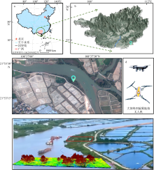
Fig. 1
Overview of the study area. (a) Map of China and the location of the Beibu Gulf Economic Zone; (b) relative location of the study area in Guangxi; (c) Gaofen 2 (GF-2) satellite image of the study area taken in October 2023; (d) model of the drone used for LiDAR point cloud data collection; (e) drone LiDAR point cloud data capture site (left) and example images of aerial photography and processed LiDAR point cloud data of the study area"

Fig. 1
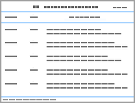
Appendix Tab. 1
Selected vegetation indices"
| 植被指数名称 | 英文名称 | 简称 | 公式 | 特点 | 参考文献 |
|---|---|---|---|---|---|
| 归一化差异 植被指数 | normalized difference vegetation index | NDVI | (RNIR−Rred)/( RNIR + Rred) | 突出观测植被的特殊光谱特征, 已经被广泛应用。可用于监测植被生长状况。该指数也可用于地表分类、区分不同的树种等领域 | Rouse et al, |
| 增强型 植被指数 | enhanced vegetation index | EVI | 2.5(RNIR − Rred) | EVI是一种优化后的植被指数, 通过对植被冠层信号的解耦, 提高了高生物量区域的反演效果的同时又能纠正土壤背景和气溶胶散射的影响。 | Huete et al, |
| 过绿指数 | excess green index | EXG | 2 Rgreen − Rred - Rblue | 这是一种泛用的监测小范围植物的植被指数 | Woebbecke et al, |
| 绿色归一化 植被指数 | normalized green difference vegetation index | GNDVI | (RNIR − Rgreen)/( RNIR + Rgreen) | 这是一种改良的NDVI指数, 与氮的相关性良好。对正在拔节、抽雄时期的植被反应精度较高 | Daughtry et al, |
| 湿度植被指数 | moisture vegetation index | MVI | (RNIR − Rred)/( RNIR + Rred) + 0.5 | 湿度植被指数不仅可以反应植被的冠层结构, 还能反应叶片属性 | 金一谔 等, |
| 归一化差异 绿度指数 | normalized difference green degree index | NDGI | (Rgreen − Rred)/( Rgreen + Rred) | 主要反应植被的光能转化 | Lyon et al, |
| 归一化 色素比值指数 | normalized pigment chlorophyll index | NPCI | (Rred − Rblue)/( Rred + Rblue) | 一种用来反应叶绿素的植被指数, 多用于植被的生长检测 | Clay et al, |
| 红色植被指数 | redness index | RI | (Rred − Rgreen)/( Rred + Rgreen) | 校正了土壤颜色对植被指数的影响 | Huete et al, |
| 结构 不敏感指数 | structure independent pigment index | SIPI | (RNIR − Rblue)/( RNIR + Rblue) | 该指数的内在逻辑为, 当植被叶面积指数降低时, 类胡萝卜指数(一种对叶绿素比率敏感的指数)和冠层应力增加 | Penuelas et al, |
| 转换植被指数 | triangle vegetation index | TVI | 60(RNIR − Rgreen)−100(Rred − Rgreen) | 该指数多用以反应植物吸收的辐射能量与红、绿、近红外波段的反射率关系, 是很好的反应生物量的指数 | Broge et al, |
Appendix Tab. 1
Appendix Tab. 2
Extracted texture indices"
| 纹理特征参数名称 | 公式 | 参考文献 |
|---|---|---|
| 均值(mean) | $\sum_{i, j=0}^{N-1} i P_{i, j}$ | Kadiyala et al, |
| 方差(variance) | $\sum_{i, j=0}^{N-1} P_{i, j}\left(1-\mu_{i}\right)$ | Kadiyala et al, |
| 同质性(homogeneity) | $\sum_{i, j=0}^{N-1} \frac{i P_{i, j}}{1+(1-j)^{2}}$ | |
| 对比度(contrast) | $\sum_{i, j=0}^{N-1} i P_{i, j}(i-j)$ | Kadiyala et al, |
| 异质性(dissimilarity) | $\sum_{i, j=0}^{N-1} i P_{i, j}|i-j|$ | |
| 熵(entropy) | $\sum_{i, j=0}^{N-1} P_{i, j}\left(-\ln P_{i, j}\right)$ | |
| 角二阶矩(angular second moment) | $\sum_{i, j=0}^{N-1}\left(i P_{i, j}\right)^{2}$ | |
| 相关性(correlation) | $\sum_{i, j=0}^{N-1} \frac{i j P_{i, j}-\mu_{i} \mu_{i j}}{\sigma_{i}^{2} \sigma_{j}^{2}}$ |
Appendix Tab. 2
Appendix Tab. 3
Laser point cloud parameters"
| 参数名称 | 说明 | 参考文献 |
|---|---|---|
| 间隙率(gap fraction) | 间隙率(P)是指在特定天顶角θ方向上, 激光脉冲能够穿透植被冠层到达地面的概率 | Shamaoma et al, |
| 叶面积指数(LAI) | $\text{LAI}=-\ln \left( P \right)\times k$ 其中, P是间隙率, k是消光系数, 通常需要根据植被类型和激光入射角进行校准 | |
| 覆盖度(coverage) | 覆盖度通常指植被冠层覆盖地面的比例。在LiDAR中, 可以通过计算冠层点云投影到地面的面积与总地面面积的比例来估算 | |
| 强度百分位(intensity percentiles) | 强度百分位是激光回波强度值的百分位数统计量。本文选用了第90百分位的强度值 |
Appendix Tab. 3
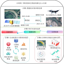
Fig. 2
Technical flowchart"
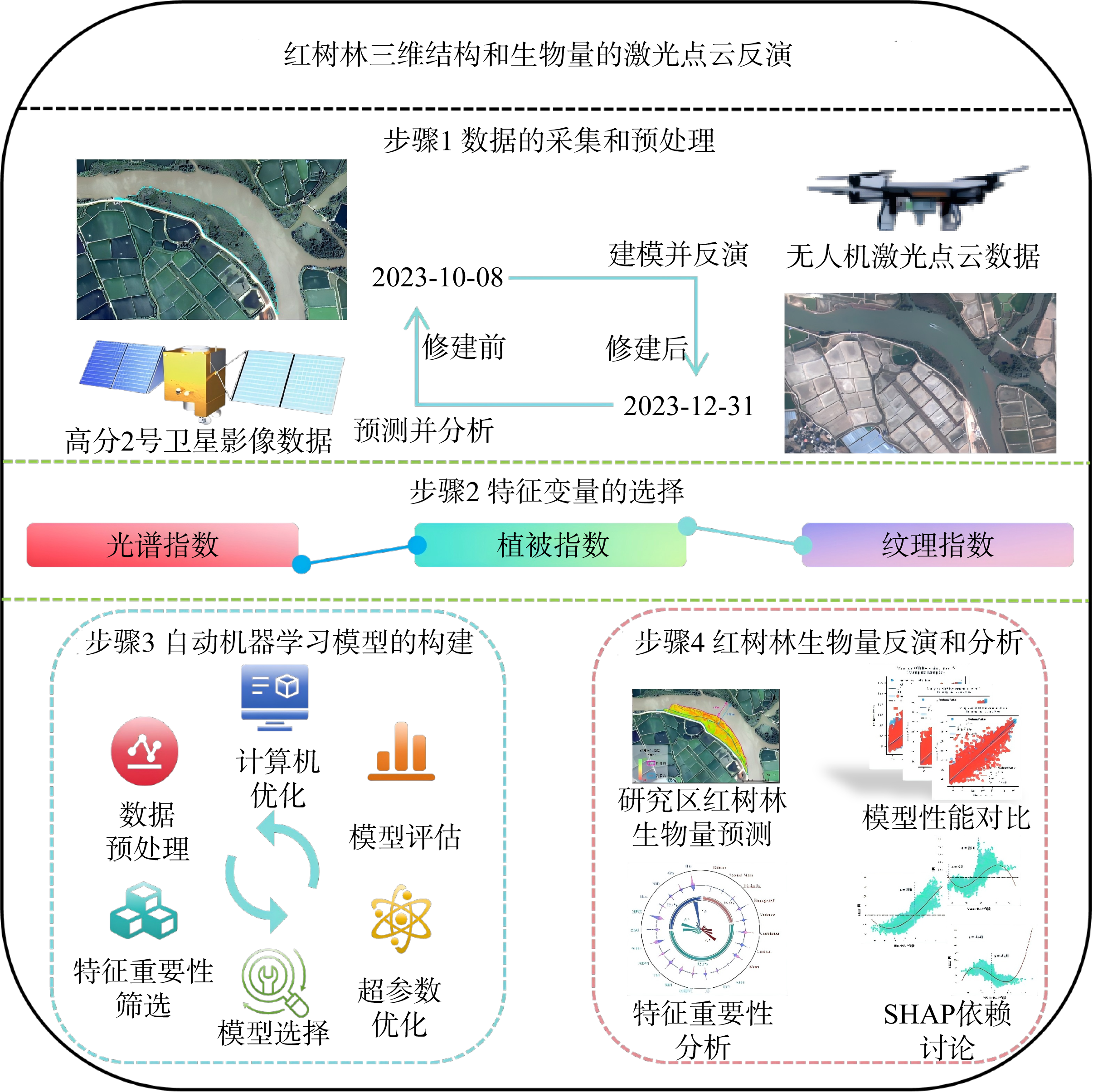
Fig. 2
Tab. 1
Contribution of each characteristic variable to inversion accuracy"
| 使用的特征变量 | 最佳模型 | 训练集精度 | 训练集标准差/(t·hm−2) | 测试集精度 | 测试集标准差/(t·hm−2) |
|---|---|---|---|---|---|
| 仅用影像原始波段 | LGBM | 0.63 | 17.20 | 0.58 | 18.67 |
| 影像波段+植被指数 | LGBM | 0.95 | 5.82 | 0.81 | 12.07 |
| 影像波段+植被指数+纹理指数 | LGBM | 0.98 | 4.36 | 0.84 | 11.32 |
| 影像波段+植被指数+纹理指数+激光点云参数 | LGBM | 0.98 | 3.39 | 0.85 | 11.20 |
Tab. 1
Tab. 2
Performance of different models in aboveground biomass prediction"
| 模型 | 训练集精度 | 训练集标准差/(t·hm−2) | 测试集精度 | 测试集标准差/(t·hm−2) |
|---|---|---|---|---|
| LGBM | 0.98 | 3.39 | 0.85 | 11.20 |
| RF | 0.97 | 4.52 | 0.82 | 12.80 |
| XGBoost | 0.98 | 3.49 | 0.84 | 11.49 |
| CatBoost | 0.92 | 7.96 | 0.83 | 11.89 |
| XGB_limitdepth | 0.99 | 2.73 | 0.83 | 11.77 |
| KNeighbor | 1 | 0 | 0.42 | 21.73 |
Tab. 2
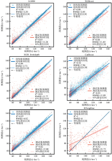
Fig. 3
Comparison of prediction performance of models under the FLAML framework"

Fig. 3
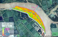
Fig. 4
Prediction result map of mangrove biomass in the study area"

Fig. 4
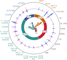
Fig. 5
SHAP analysis diagram of each characteristic variable"

Fig. 5
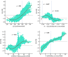
Fig. 6
SHAP dependence of the optimal variable among four types of characteristic variables"

Fig. 6
Tab. 3
Impact of runtime (number of iterations) on models"
| 运行时间 | 迭代次数 | 训练集精度 | 训练集标准差/(t·hm−2) | 测试集精度 | 测试集标准差(/t·hm−2) |
|---|---|---|---|---|---|
| 10s | 10 | 0.77 | 13.69 | 0.68 | 15.69 |
| 20s | 14 | 0.88 | 9.71 | 0.77 | 13.31 |
| 30s | 17 | 0.91 | 8.30 | 0.80 | 12.60 |
| 45s | 19 | 0.98 | 3.39 | 0.85 | 11.20 |
| 60s | 21 | 0.98 | 3.39 | 0.85 | 11.20 |
Tab. 3
| [1] |
敖登, 杨佳慧, 丁维婷, 等, 2023. 54种植被指数研究进展综述[J]. 安徽农业科学, 51(1): 13-21+28.
|
|
|
|
| [2] |
金一谔, 刘长盛, 张文忠, 1998. 利用气象卫星GMS和AVHRR资料推算地面水分含量的方法[J]. 应用气象学报, 9(2): 197-204.
|
|
|
|
| [3] |
doi: 10.1017/S0376892902000231 |
| [4] |
doi: 10.1146/annurev-marine-010213-135020 pmid: 24405426 |
| [5] |
doi: 10.3390/f13101545 |
| [6] |
doi: 10.1016/j.biortech.2023.129436 |
| [7] |
doi: 10.1890/1540-9295(2006)004[0124:NBTNDR]2.0.CO;2 |
| [8] |
doi: 10.1016/S0034-4257(00)00197-8 |
| [9] |
doi: 10.1126/science.223.4642.1290 pmid: 17759366 |
| [10] |
doi: 10.1007/s11705-024-2487-0 |
| [11] |
|
| [12] |
doi: 10.2134/agronj2005.0204 |
| [13] |
doi: 10.1016/j.ppees.2007.11.001 |
| [14] |
doi: 10.1016/0034-4257(92)90132-4 |
| [15] |
doi: 10.1016/j.scitotenv.2022.154707 |
| [16] |
doi: 10.1080/01431161.2012.712224 |
| [17] |
doi: 10.1080/01431161.2017.1285083 |
| [18] |
|
| [19] |
doi: 10.1016/j.ecss.2017.11.004 |
| [20] |
doi: 10.1016/S0034-4257(02)00096-2 |
| [21] |
doi: 10.1016/0034-4257(91)90008-T |
| [22] |
doi: 10.1016/j.apgeog.2013.09.024 |
| [23] |
|
| [24] |
doi: 10.3390/rs3050878 |
| [25] |
|
| [26] |
doi: 10.3390/su17188211 |
| [27] |
doi: 10.1890/110004 |
| [28] |
doi: 10.1186/s13021-021-00172-9 pmid: 33730236 |
| [29] |
doi: 10.7717/peerj-cs.2188 pmid: 39145237 |
| [30] |
doi: 10.1038/nclimate2734 |
| [31] |
doi: 10.1007/s00468-015-1334-9 |
| [32] |
|
| [33] |
doi: 10.1016/j.jag.2024.103769 |
| [34] |
doi: 10.1117/1.JRS.11.026010 |
| [35] |
doi: 10.1080/01431161.2018.1471544 |
| [36] |
doi: 10.3390/rs11030230 |
| [37] |
doi: 10.1016/j.rse.2020.112165 |
| [38] |
doi: 10.1016/j.rsase.2022.100725 |
| [39] |
doi: 10.1088/1748-9326/ac31ee |
| [40] |
|
| [41] |
|
| [42] |
doi: 10.1016/j.ecss.2020.106585 |
| [43] |
doi: 10.1186/s13007-024-01212-4 pmid: 38849856 |
| [44] |
|
| [45] |
doi: 10.3390/su10020472 |
| [46] |
doi: 10.1016/j.scitotenv.2021.146816 |
| [47] |
doi: 10.3390/rs14194868 |
| [48] |
|
| [49] |
doi: 10.3390/computers10010011 |
| [50] |
doi: 10.1038/s41597-025-04881-5 |
| [51] |
doi: 10.1109/Access.6287639 |
| [52] |
doi: 10.1080/01431161.2015.1117679 |
| [53] |
doi: 10.13031/2013.27838 |
| [54] |
|
| [55] |
|
| [1] | LIANG Xixing, DAI Zhijun, LI Yan, LI Shushi, LI Weihua, WANG Riming, WU Erjiang. Spatiotemporal dynamics of mangroves at the Pinglu Canal estuary based on Sentinel-2 [J]. Journal of Tropical Oceanography, 2026, 45(4): 77-88. |
| [2] | QI Feng, DENG Xiaojie, GUAN Yongpeng, ZHOU Shengyao, HE Qing, RAJAPAKSHALAGE Thashikala Nethmini, LI Nan, JIANG Gonglingxia, CHEN Qingxiang, LEI Xinyue, HOU Qinghua, HUANG Laizhen, LI Xiaolei, WEI Qiaoyan. Study on the stability and complexity of diazotrophic communities and key driving factors in the root-associated zones of the mangrove plant Kandelia obovata [J]. Journal of Tropical Oceanography, 2026, 45(3): 153-163. |
| [3] | TAN Qingbi, GUO Hongying, SUN Siqi, ZHONG Yuhang, NIE Hui, NIU Lixia. Analysis of nitrogen sources and influencing factors in mangrove sediments of the Qingjiang River estuary (Zhejiang) using stable isotopes [J]. Journal of Tropical Oceanography, 2026, 45(3): 202-211. |
| [4] | FANG Yang, TANG Junyi, LUO Yuchi, YE Kuangmin, DENG Weihua. Impacts of exotic mangrove introduction on ecosystem health and service functions: A case study of three representative regions in Guangdong Province [J]. Journal of Tropical Oceanography, 2026, 45(2): 173-190. |
| [5] | JIANG Shoudian, HU Xin, LAN Peixin, YAO Liqin, SHUI Bonian, JI Jianda, HE Maoqiu. Seasonal distribution characteristics and environmental driving factors of bacterial communities in mangrove sediments of Ximen Island, Zhejiang Province [J]. Journal of Tropical Oceanography, 2026, 45(2): 117-128. |
| [6] | SU Chunqing, GAO Yuhui, LUO Xinwu, HAN Mengmeng, GONG Yanzhang, ZHENG Weiguo. Forest biomass and carbon storage of different mangrove communities in Shenzhen, China [J]. Journal of Tropical Oceanography, 2025, 44(6): 155-164. |
| [7] | WANG Riming, SU Jinheng, DAI Zhijun, WU Tianliang, XIE Xiaowen, HUANG Chunmei, LI Xingrong, ZHANG Shangyu. Dynamic changes in mangrove wetland of the Maolingjiang Estuary, Qinzhou Gulf [J]. Journal of Tropical Oceanography, 2025, 44(6): 143-154. |
| [8] | XIE Xiaokui, LI Xingrong, WANG Riming, DAI Zhijun, GONG Shouji, PANG Wenhong, ZHANG Shangyu. Spatiotemporal succession of the exotic mangrove Sonneratia apetala in the Maowei Sea tidal flats, Beibu Gulf [J]. Journal of Tropical Oceanography, 2025, 44(6): 132-142. |
| [9] | HU Xin, XIONG Lanlan, CHEN Shunyang, ZHANG Huangchen, ZOU Yiyang, ZHANG Jichao, LIU Dongxi, HE Jialu, WU Yuqi, ZHU Zhenjie. Study on biomass models of juvenile mangroves and carbon storage in young mangrove ecosystems* [J]. Journal of Tropical Oceanography, 2025, 44(4): 187-199. |
| [10] | TIAN Mi, ZHONG Cairong, LYU Xiaobo, FANG Zanshan, HUANG Danmin. Comparison of mangrove community characteristics in different pond-to-mangrove models in Dongzhaigang [J]. Journal of Tropical Oceanography, 2025, 44(3): 58-65. |
| [11] | YUAN Yujie, ZHONG Shiquan, JIANG Weiguo, CHU Aiping, LING Ziyan. Study on mangrove pests and diseases monitoring for Tieshan Port in 2023 based on HJ-2A/B satellites [J]. Journal of Tropical Oceanography, 2025, 44(3): 188-196. |
| [12] | LIU Sini, BAI Meng, ZHU Yiguang, LUO Xiaowei, GAO Chenghai, LIU Yonghong, XU Xinya, JIANG Xiaodong. 2-Hydroxyphenyl thiazoline derivatives and their biosynthetic gene clusters from the mangroves-derived Strepomyces ardesiacus [J]. Journal of Tropical Oceanography, 2025, 44(2): 64-72. |
| [13] | WU Xue, ZHAO Xin, GU Weifang, ZHU Kehua, GE Zhenming. Comparative study on soil carbon sinks of artificial Kandelia obovate mangrove and Spartina alterniflora salt marsh in the southern Zhejiang coastal zone [J]. Journal of Tropical Oceanography, 2025, 44(1): 172-181. |
| [14] | HUANG Liangmin, LIN Qiang, TAN Yehui, HUANG Xiaoping, ZHOU Linbin, HUANG Hui. Thoughts on the restoration, reconstruction and protection of typical tropical marine ecosystems [J]. Journal of Tropical Oceanography, 2024, 43(6): 1-12. |
| [15] | AN Fan, JIANG Yue, WANG Yu, CAO Guangping, GAO Chenghai, LIU Yonghong, YI Xiangxi, BAI Meng. Studies on secondary metabolites of endophytic fungus Aspergillus terreus GXIMD 03158 isolated from mangroves Acanthus ilicifolius L. [J]. Journal of Tropical Oceanography, 2024, 43(5): 41-48. |
|
||