
热带海洋学报 ›› 2020, Vol. 39 ›› Issue (4): 116-129.doi: 10.11978/2019100CSTR: 32234.14.2019100
• 海洋调查与观测 • 上一篇
基于高分辨率遥感的珊瑚礁地貌单元体系构建和分类方法—以8波段Worldview-2影像为例
董娟1( ), 任广波1(), 胡亚斌1,2, 逄今朝1,3, 马毅1
- 1.自然资源部第一海洋研究所, 山东 青岛 266061
2.大连海事大学信息科学技术学院, 辽宁 大连 116026
3.中国石油大学(华东), 山东 青岛 266580
-
收稿日期:2019-10-12修回日期:2020-02-02出版日期:2020-07-20发布日期:2020-07-27 -
通讯作者:任广波 -
作者简介:董娟(1995—), 女, 硕士研究生, 主要从事珊瑚礁遥感监测研究。Email:dongj_0829@163.com -
基金资助:国家自然科学基金项目(51839002)
Construction and classification of coral reef geomorphic unit system based on high-resolution remote sensing: using 8-band Worldview-2 Image as an example
Juan DONG1(), Guangbo REN1(), Yabin HU1,2, Jinzhao PANG1,3, Yi MA1
- 1. First Institute of Oceanography, Ministry of Natural Resources, Qingdao 266061, China
2. Information Science and Technology College, Dalian Maritime University, Dalian 116026, China
3. China University of Petroleum, Qingdao 266580, China
-
Received:2019-10-12Revised:2020-02-02Online:2020-07-20Published:2020-07-27 -
Contact:Guangbo REN -
Supported by:Foundation item: National Natural Science Foundation of China(51839002)
摘要:
珊瑚礁生态系统是全球初级生产力最高的生态系统之一, 在维持海洋生物多样性、防浪固滩、资源供给等方面发挥着巨大作用。珊瑚礁遥感地貌分类体系是珊瑚礁保护、管理及可持续发展的必要基础, 但目前还未有结合珊瑚覆盖度进行分类的体系。本文基于WorldView-2高分辨率遥感影像, 以中国南海西沙群岛七连屿北部赵述岛和西沙洲所在礁盘作为研究区, 结合珊瑚覆盖度、区域地貌成分和水动力条件等指标, 建立了既适用于遥感监测又与珊瑚生存状况相关联的珊瑚礁地貌单元分类体系。同时, 利用面向对象的支持向量机(Support Vector Machine, SVM)和随机森林(Random Forest, RF)分类方法进行珊瑚礁地貌单元的信息提取, 并对分类结果进行精度评价。结果表明, SVM和RF两种分类方法均能较好地提取出珊瑚礁地貌单元, 分类精度分别为87.59%和79.81%。针对分类过程中出现的错分、漏分问题, 结合珊瑚礁成因和分布规律对分类结果进行修正, 修正后分类提取的精度达到91.3%, Kappa系数为0.9041, 表明本文构建的珊瑚礁地貌单元分类体系在一定程度上能满足当前珊瑚岛礁信息提取的需要。
中图分类号:
- P737.2
引用本文
董娟, 任广波, 胡亚斌, 逄今朝, 马毅. 基于高分辨率遥感的珊瑚礁地貌单元体系构建和分类方法—以8波段Worldview-2影像为例[J]. 热带海洋学报, 2020, 39(4): 116-129.
Juan DONG, Guangbo REN, Yabin HU, Jinzhao PANG, Yi MA. Construction and classification of coral reef geomorphic unit system based on high-resolution remote sensing: using 8-band Worldview-2 Image as an example[J]. Journal of Tropical Oceanography, 2020, 39(4): 116-129.

图1
研究区位置示意图 图a基于标准地图服务网(http://bzdt.ch.mnr.gov.cn)下载的审图号为GS(2016)2891号的标准地图制作"
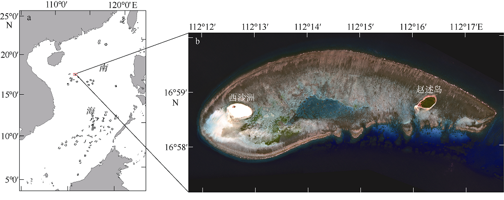
图1
表1
WorldView-2影像信息"
| 波段名称 | 波长/nm | 分辨率/m | 幅宽/km | 重访周期/d |
|---|---|---|---|---|
| 海岸(Coastal) | 400~450 | 1.85 | 16.4 | 1.1 |
| 蓝(Blue) | 450~510 | 1.85 | 16.4 | 1.1 |
| 绿(Green) | 510~580 | 1.85 | 16.4 | 1.1 |
| 黄(Yellow) | 585~625 | 1.85 | 16.4 | 1.1 |
| 红(Red) | 630~690 | 1.85 | 16.4 | 1.1 |
| 红边(Red Edge) | 705~745 | 1.85 | 16.4 | 1.1 |
| 近红外(Near-IR1) | 770~895 | 1.85 | 16.4 | 1.1 |
| 近红外2(Near-IR2) | 860~1040 | 1.85 | 16.4 | 1.1 |
表1
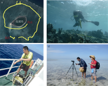
图2
现场调查的路线(a)、潜水调查(b)和摄影记录(c、d)"

图2
表2
珊瑚礁地貌单元主要底质组成"
| 珊瑚礁地貌单元 | 主要底质组成 |
|---|---|
| 深礁前斜坡 | 粉砂质黏土(浅)、细砂(深) |
| 浅礁前斜坡 | 小礁块、生物碎屑 |
| 礁前阶地 | 死珊瑚、贝壳砾屑、珊瑚藻 |
| 礁脊 | 礁块、礁砾、珊瑚藻 |
| 珊瑚丛生区 | 珊瑚礁岩、生物碎屑 |
| 珊瑚沉积区 | 珊瑚砂 |
| 礁塘 | 珊瑚砂 |
| 点礁 | 基本为活珊瑚 |
| 潟湖坡 | 生物碎屑 |
| 沙洲 | 珊瑚砂、其他生物碎屑 |
| 沙坪 | 珊瑚砂、其他生物碎屑 |
表2
表3
已有的珊瑚礁地貌分类体系"
| 建立方法 | 文献来源 | 遥感数据 | 分类体系 |
|---|---|---|---|
| 实地调查 | — | 礁后: 海岸带、潟湖; 礁脊: 邻近潟湖带、礁坪、破碎带、贫瘠带、礁凸起带; 向海斜坡: 礁前斜坡、深礁前斜坡带; 共9类。 | |
| — | 礁坡区; 礁盘区: 外礁盘、堤滩、次成潟湖、沙岛区(海滩岩、沙堤带、中部洼地); 潟湖区: 点礁; 共8类。 | ||
| — | 向海坡; 外礁坪; 礁凸起; 内礁坪: 珊瑚稀疏带、珊瑚丛林带、礁坑发育带; 潟湖: 潟湖坡、潟湖盆、点礁; 共9类。 | ||
| — | 礁后; 礁脊; 潮沟: 低潮沟、高潮沟; 礁前; 急陡坡; 点礁: 浓密点礁、分散点礁; 潟湖层: 浅潟湖层、深潟湖层; 共10类。 | ||
| 遥感影像 | Landsat ETM+ | 礁前; 礁脊; 礁坪: 珊瑚带、砂礁坪、海草床、植被沙洲; 潟湖: 砂质礁后、潟湖点礁、深潟湖; 点礁; 共10类。 | |
| QucikBird-2 | 礁坡; 礁脊; 外礁坪; 内礁坪; 浅潟湖; 深潟湖; 共6类。 | ||
| WorldView-2 | 水下礁脊; 外礁坪; 礁凸起带; 附礁生物稀疏带; 附礁生物丛生带; 礁坑发育带; 潟湖: 潟湖坡、潟湖底; 点礁; 潮汐通道; 沙洲; 灰沙岛: 海滩、沙堤、沙席、洼地; 共15类。 | ||
| CBERS-03B CCD | 向海坡; 礁前; 礁坪: 礁脊、槽沟、珊瑚生长带、礁坑发育带; 潟湖: 潟湖坡、潟湖盆、潟湖点礁; 潮汐通道; 暗沙/暗滩; 灰沙岛: 海滩、沙丘; 共13类。 | ||
| WorldView-2 | 外礁缘; 外礁坪; 礁突起带; 内礁坪: 生物稀疏带、生物密集带、礁坑发育带; 潟湖: 潟湖坡、潟湖盆、点礁; 沙洲; 共10类。 | ||
| WorldView-2、QucikBird | 水下礁脊; 礁前斜坡: 礁前斜坡下坡、礁前斜坡上坡; 礁坪: 外礁坪、礁凸起带、内礁坪(生物稀疏带、潮间带浅滩、生物丛生带、礁坑发育带); 潟湖: 潟湖坡、潟湖底、点礁、潮汐通道; 浅水礁塘; 沙洲; 灰沙岛: 海滩、沙堤、沙席、洼地; 共19类。 | ||
| Landsat-8 OLI | 植被; 岛屿/沙洲; 礁坪; 水下部分; 共4类。 |
表3
表4
本文珊瑚礁地貌单元分类体系"
| Ⅰ级 | Ⅱ级 | 定义 | 珊瑚覆盖度 | 影像纹理特征 | 解译标志 |
|---|---|---|---|---|---|
| 向海坡 | 深礁前斜坡 | 坡度和缓, 呈切割起伏型, 为波浪基面以下坡度小于40°的坡面, 50~1000m水深处多是细砂, 1000m以下为粉砂质黏土( | 由于较强的水动力, 冲蚀与溶蚀作用抑制了珊瑚的生长, 活珊瑚覆盖度小于50%( | 处于礁体的最外围, 影像中最深的蓝黑色部分, 白色条状沟槽几乎很少 | |
| 浅礁前斜坡 | 礁缘外向海一侧的水下斜坡, 位于水深30m左右的波浪基面以上, 坡度达50°以上, 多数呈峭壁状, 少数呈缓坡状; 一般为硬底质( | 此区域水动力作用不强, 即海浪对珊瑚的生长发育影响较小, 种类繁多、形态各异的活珊瑚几乎达到全覆盖( | 处于深礁前斜坡的内侧, 是更浅的蓝黑色, 白色条状沟槽开始增多 | | |
| 礁前 阶地 | 位于礁脊和浅礁前斜坡之间, 紧邻海浪破波带; 此处有礁缘槽沟发育, 由礁缘坡折线到沟头宽20~25m( | 此处水动力较强( | 处于浅礁前斜坡的内侧, 颜色为较均匀的灰色, 在外侧边缘有白色浪花存在 | | |
| Ⅰ级 | Ⅱ级 | 定义 | 珊瑚覆盖度 | 影像纹理特征 | 解译标志 |
| 礁坪 | 礁脊 | 展布在礁坪前缘、环礁外缘礁带内侧, 存在锯齿状沟槽, 低潮时完全干出, 一般高出礁坪1m以上, 抗浪性强; 一般为硬底质堆积, 多由礁块或礁砾组成( | 因受到强烈的水动力作用, 只有零星珊瑚生长或只有一层珊瑚藻覆盖着的平滑礁脊( | 处于礁前阶地的内侧, 颜色为灰色并带有较少的黑灰色, 主要是带锯齿的竖条状纹理 | |
| 珊瑚丛生区 | 表面凹凸不平, 并大多处在低潮面下30~50cm( | 水动力较弱, 是抗浪性差的珊瑚群落的优良生长区, 有众多活珊瑚( | 处于礁脊的内侧, 影像中颜色最深的部分, 颜色为较均匀的黑灰色 | | |
| 珊瑚沉积区 | 位于珊瑚丛生带内侧, 以沉积作用为主, 多有礁坑发育, 礁坑堆积有白色的珊瑚砂, 大潮低潮时局部礁面微露, 除部分礁坑外, 珊瑚沉积区地势宽广平坦 | 稀疏的珊瑚及附礁生物( | 处于珊瑚丛生区的内侧, 主要为灰色, 有较少的蓝色和黑色相间, 内部有边界模糊的黑色小斑块 | | |
| 礁塘 | 珊瑚丛生区或珊瑚沉积区上常积水的低洼地, 深几十厘米至数米, 低潮时不出露, 底质为砂质 | 水动力较弱, 内部零星分布有点礁( | 处于礁坪的中心部分, 颜色为亮蓝色, 其中有边界明显的黑色斑块 | | |
| 潟湖 | 点礁 | 又称斑礁, 指由潟湖底部或斜坡上显著突出的墩状珊瑚礁, 且彼此孤立、平面上呈点状分布的礁体( | 礁体顶面有很多种类的珊瑚丛生( | 深蓝色海水中边界明显的黑蓝色斑块 | |
| 潟湖坡 | 位于礁后, 易于维持水道的背风面, 呈扩散性边缘, 深度30~40m左右, 个别超过200m | 有点礁分布, 其上有分枝状珊瑚生长, 但珊瑚生长情况较差( | 颜色为深蓝色, 其中零星分布黑蓝色斑块 | | |
| 灰沙岛 | 沙洲 | 风浪的作用使沙坪规模变大, 砂质物质增加, 可积存少量淡水, 甚至有植被发育, 地形相对沙坪稳定 | 无珊瑚生长 | 颜色为十分均匀的黄白色,与其他地物界限明显 | |
| 沙坪 | 在新近浮出海面的珊瑚礁上, 具有称为“沙帽”的一层浅沙, 当堆积物堆高超出海面后, 形成沙洲。底质较硬, 由松散的珊瑚砂砾、贝壳碎屑和其他生物碎屑等组成。海拔高度很低, 常受到潮水冲刷, 大风浪可将其淹没, 其上多砾质, 植被很少, 位置游移不定。 | 无珊瑚生长 | 颜色为较明亮的蓝白色, 间有少量黑灰色的纹理或斑块 | |
表4

图3
技术路线图"
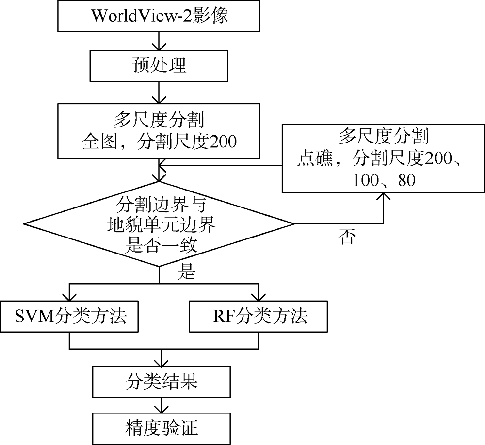
图3
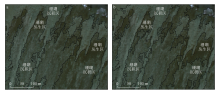
图4
珊瑚丛生区和珊瑚沉积区在尺度参数为500(a)和200(b)下的分割效果、"
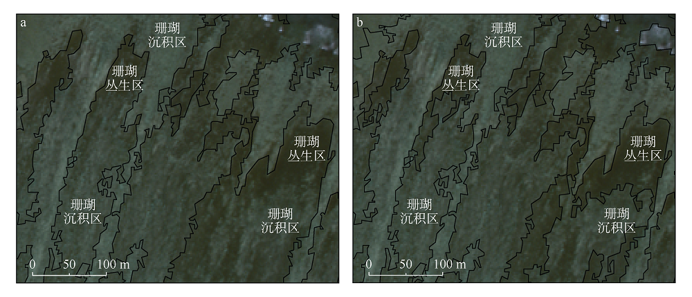
图4
图5
尺度参数分别为200(a)、100(b)和80(c)的点礁分割结果"
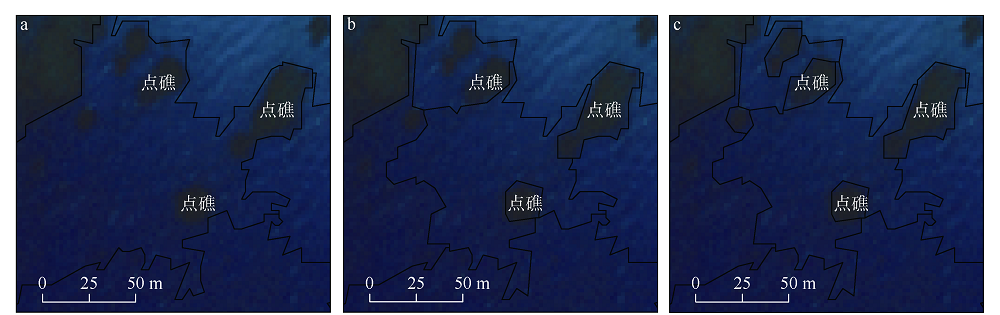
图5
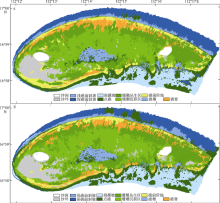
图6
基于面向对象的支持向量机(SVM)分类结果(a)和随机森林(RF)分类结果(b)"

图6
表5
基于面向对象的支持向量机(SVM)和随机森林(RF)分类精度"
| SVM分类精度 | RF分类精度 | |||||
|---|---|---|---|---|---|---|
| PA/% | UA/% | PA/% | UA/% | |||
| 地貌类型 | 深礁前斜坡 | 63.41 | 84.4 | 63.41 | 85.65 | |
| 浅礁前斜坡 | 71.05 | 67.02 | 43.83 | 55.63 | ||
| 礁前阶地 | 82.81 | 77.86 | 71.23 | 75.15 | ||
| 礁脊 | 100 | 84.09 | 98.64 | 75.7 | ||
| 珊瑚丛生区 | 100 | 89.81 | 100 | 89.09 | ||
| 珊瑚沉积区 | 100 | 100 | 100 | 100 | ||
| 点礁 | 85.97 | 80.03 | 88.28 | 38.05 | ||
| 礁塘 | 100 | 93.14 | 58.35 | 99.81 | ||
| 潟湖坡 | 94.14 | 100 | 100 | 100 | ||
| 沙洲 | 100 | 100 | 100 | 82.47 | ||
| 沙坪 | 71.54 | 100 | 71.54 | 98.94 | ||
| 植被 | 100 | 100 | 80.69 | 100 | ||
| 总体精度/% | 87.59 | 79.81 | ||||
| Kappa系数 | 0.8631 | 0.7780 | ||||
表5
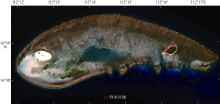
图7
样本区域示意图"

图7
表6
研究区各地貌单元珊瑚覆盖度估算"
| 地貌单元 | 深礁前斜坡 | 浅礁前斜坡 | 礁前 阶地 | 礁脊 | 珊瑚丛生区 | 珊瑚沉积区 | 礁塘 | 点礁 | 潟湖坡 | 沙洲 | 沙坪 | 植被 |
|---|---|---|---|---|---|---|---|---|---|---|---|---|
| 覆盖度/% | 30~40 | 80~90 | 10~20 | 0 | 80~90 | 30~40 | 0 | 80~90 | 0 | 0 | 0 | 0 |
表6
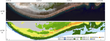
图8
错分区域相应影像(a)及分类结果(b)"
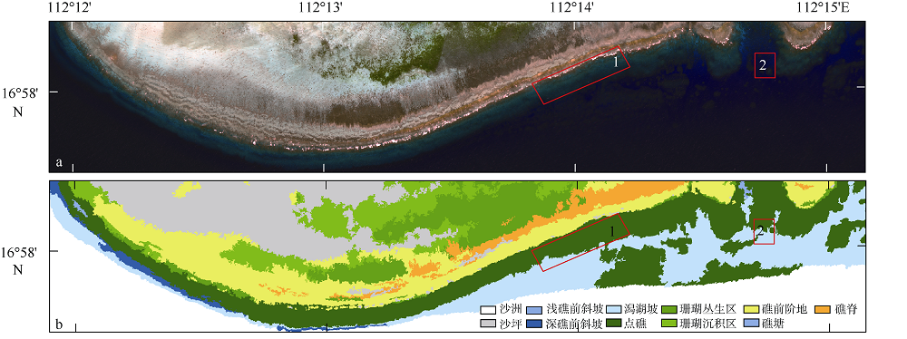
图8
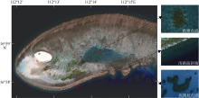
图9
浅礁前斜坡、礁塘点礁和潟湖坡点礁的颜色特征对比"
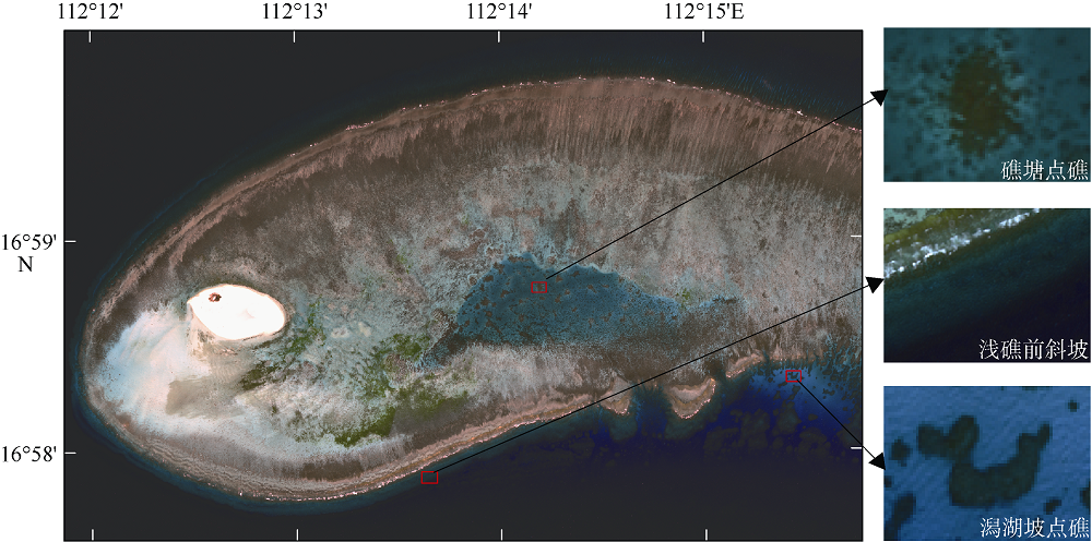
图9

图10
浅礁前斜坡、礁塘点礁和潟湖坡点礁光谱曲线对比"
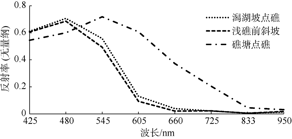
图10

图11
修正后基于面向对象的支持向量机(SVM)分类结果"
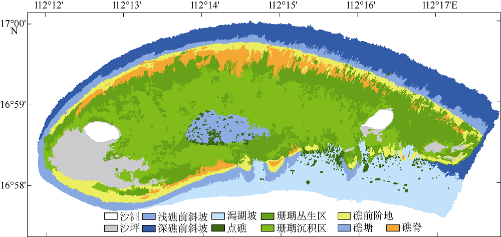
图11
| [1] | 陈云浩, 冯通, 史培军, 等, 2006. 基于面向对象和规则的遥感影像分类研究[J]. 武汉大学学报·信息科学版, 31(4):316-320. |
| CHEN YUNHAO, FENG TONG, SHI PEIJUN, et al, 2006. Classification of remote sensing image based on object oriented and class rules[J]. Geomatics and information science of Wuhan University, 31(4):316-320 (in Chinese with English abstract). | |
| [2] | 程益锋, 黄文骞, 吴迪, 等, 2018. 基于高分一号卫星影像的珊瑚岛礁分类方法[J]. 海洋测绘, 38(6):49-53. |
| CHENG YIFENG, HUANG WENQIAN, WU DI, et al, 2018. Coral reefs classification methods based on GF-1 satellite image[J]. Hydrographic Surveying and Charting, 38(6):49-53 (in Chinese with English abstract). | |
| [3] | 佃袁勇, 方圣辉, 姚崇怀, 2016. 多尺度分割的高分辨率遥感影像变化检测[J]. 遥感学报, 20(1):129-137. |
| DIAN YUANYONG, FANG SHENGHUI, YAO CHONGHUAI, 2016. Change detection for high-resolution images using multilevel segment method[J]. Journal of Remote Sensing, 20(1):129-137 (in Chinese with English abstract). | |
| [4] |
龚剑明, 朱国强, 杨娟, 等, 2014. 面向对象的南海珊瑚礁地貌单元提取[J]. 地球信息科学学报, 16(6):997-1004.
doi: 10.3724/SP.J.1047.2014.00997 |
|
GONG JIANMING, ZHU GUOQIANG, YANG JUAN, et al, 2014. A study on the object-oriented model for geomorphic unit extraction of coral reefs in the South China Sea[J]. Journal of Geo-Information Science, 16(6):997-1004 (in Chinese with English abstract).
doi: 10.3724/SP.J.1047.2014.00997 |
|
| [5] | 顾海燕, 闫利, 李海涛, 等, 2016. 基于随机森林的地理要素面向对象自动解译方法[J]. 武汉大学学报·信息科学版, 41(2):228-234. |
| GU HAIYAN, YAN LI, LI HAITAO, et al, 2016. An object-based automatic interpretation method for Geographic features based on random forest machine learning[J]. Geomatics and Information Science of Wuhan University, 41(2):228-234 (in Chinese with English abstract). | |
| [6] | 李晓峰, 张树清, 刘强, 等, 2009. 高分辨率遥感影像的快速分割方法[J]. 红外与毫米波学报, 28(2):146-150. |
| LI XIAOFENG, ZHANG SHUQING, LIU QIANG, et al, 2009. Fast segmentation method of high-resolution remote sensing image[J]. Journal of Infrared and Millimeter Waves, 28(2):146-150 (in Chinese with English abstract). | |
| [7] | 李元超, 陈石泉, 郑新庆, 等, 2018. 永兴岛及七连屿造礁石珊瑚近10年变化分析[J]. 海洋学报, 40(8):97-109. |
| LI YUANCHAO, CHEN SHIQUAN, ZHENG XINGING, et al, 2018. Analysis of the change of hermatypic corals in Yongxing Island and Qilianyu Island in nearly a decade[J]. Acta Oceanologica Sinica, 40(8):97-109 (in Chinese with English abstract). | |
| [8] | 刘宝银, 刘琳, 2014. 印度洋马尔代夫环礁发育空间特征——航天遥感融合信息海气关联[M]. 北京: 海洋出版社 (in Chinese). |
| [9] | 仇江啸, 王效科, 2016. 基于高分辨率遥感影像的面向对象城市土地覆被分类比较研究[J]. 遥感技术与应用, 25(5):653-661. |
| QIU JIANGXIAO, WANG XIAOKE, 2016. A comparative study on object-based land cover classification in high spatial resolution remote sensing imagery of Urban areas[J]. Remote Sensing Technology and Application, 25(5):653-661 (in Chinese with English abstract). | |
| [10] | 夏东兴, 边淑华, 丰爱平, 等, 2014. 海岸带地貌学[M]. 北京: 海洋出版社 (in Chinese). |
| [11] | 余克服, 2012. 南海珊瑚礁及其对全新世环境变化的记录与响应[J]. 中国科学:地球科学, 42(08):1160-1172. |
| YU KEFU, 2012. Coral reefs in the South China Sea: Their response to and records on past environmental changes[J]. Sci China Earth Sci, 42(08):1160-1172 (in Chinese with English abstract). | |
| [12] | 曾昭璇, 1982. 中国环礁的类型划分[J]. 海洋通报, (4):46-53 (in Chinese). |
| [13] | 张华, 张改改, 2018. 面向对象的GF-1遥感影像多尺度分割研究[J]. 甘肃农业大学学报, 53(4):116-123. |
| ZHANG HUA, ZHANG GAIGAI, 2018. Study on multi-scale segmentation of GF-1 remote sensing image with object-oriented method[J]. Journal of Gansu Agricultural University, 53(4):116-123 (in Chinese with English abstract). | |
| [14] | 张晓羽, 李凤日, 甄贞, 等, 2016. 基于随机森林模型的陆地卫星-8遥感影像森林植被分类[J]. 东北林业大学学报, 44(6):53-57, 74. |
| ZHANG XIAOYU, LI FENGRI, ZHEN ZHEN, et al, 2016. Forest vegetation classification of landsat8 remote sensing image based on random forests model[J]. Journal of Northeast Forestry University, 44(6):53-57, 74 (in Chinese with English abstract). | |
| [15] | 赵焕庭, 温孝胜, 孙宗勋, 等, 1996. 南沙群岛珊瑚礁自然特征[J]. 海洋学报, 18(5):61-70 (in Chinese). |
| [16] | 周安发, 周家香, 2012. 一种高分辨率遥感影像道路信息提取方法[J]. 遥感技术与应用, 27(1):94-99. |
| ZHOU ANFA, ZHOU JIAXIANG, 2012. A methodology for road extraction from high resolution remote sensing images[J]. Remote Sensing Technology and Application, 27(1):94-99 (in Chinese with English abstract). | |
| [17] |
周旻曦, 刘永学, 李满春, 等, 2015. 多目标珊瑚岛礁地貌遥感信息提取方法——以西沙永乐环礁为例[J]. 地理研究, 34(4):677-690.
doi: 10.11821/dlyj201504007 |
|
ZHOU MINXI, LIU YONGXUE, LI MANCHUN, et al, 2015. Geomorphologic information extraction for multi-objective coral islands from remotely sensed imagery: A case study for Yongle Atoll, South China Sea[J]. Geographical Research, 34(4):677-690 (in Chinese with English abstract).
doi: 10.11821/dlyj201504007 |
|
| [18] | 朱海天, 冯倩, 梁超, 等, 2015. 基于随机森林的南沙岛礁分类方法研究, [C]// “一带一路”战略与海洋科技创新——中国海洋学会2015年学术论文集. 北京: 海洋出版社: 99-104(in Chinese). |
| [19] |
左秀玲, 苏奋振, 赵焕庭, 等, 2018. 南海珊瑚礁高分辨率遥感地貌分类体系研究[J]. 地理科学进展, 37(11):1463-1472.
doi: 10.18306/dlkxjz.2018.11.003 |
|
ZUO XIULING, SU FENZHEN, ZHAO HUANTING, et al, 2018. Development of a geomorphic classification scheme for coral reefs in the South China Sea based on high-resolution satellite images[J]. Progress in Geography, 37(11):1463-1472 (in Chinese with English abstract).
doi: 10.18306/dlkxjz.2018.11.003 |
|
| [20] |
BREIMAN L, 2001. Random forests[J]. Machine Learning, 45(1):5-32.
doi: 10.1023/A:1010933404324 |
| [21] |
DONG YANZHU, LIU YONGXUE, HU CHUANMIN, et al, 2019. Coral reef geomorphology of the Spratly Islands: A simple method based on time-series of Landsat-8 multi-band inundation maps[J]. ISPRS Journal of Photogrammetry and Remote Sensing, 157:137-154.
doi: 10.1016/j.isprsjprs.2019.09.011 |
| [22] |
FOODY G M, MATHUR A, 2004. A relative evaluation of multiclass image classification by support vector machines[J]. IEEE Transactions on Geoscience and Remote Sensing, 42(6):1335-1343.
doi: 10.1109/TGRS.2004.827257 |
| [23] |
GOREAU T F, 1959. The ecology of Jamaican coral reefs I. species composition and zonation[J]. Ecology, 40(1):67-90.
doi: 10.2307/1929924 |
| [24] |
HAMYLTON S M, CARVALHO R C, DUCE S, et al, 2016. Linking pattern to process in reef sediment dynamics at Lady Musgrave Island, southern great barrier reef[J]. Sedimentology, 63(6):1634-1650.
doi: 10.1111/sed.12278 |
| [25] |
KAYANNE H, AOKI K, SUZUKI T, et al, 2016. Eco-geomorphic processes that maintain a small coral reef island: Ballast Island in the Ryukyu Islands, Japan[J]. Geomorphology, 271:84-93.
doi: 10.1016/j.geomorph.2016.07.021 |
| [26] |
LEON J, WOODROFFE C D, 2011. Improving the synoptic mapping of coral reef geomorphology using object-based image analysis[J]. International Journal of Geographical Information Science, 25(6):949-969.
doi: 10.1080/13658816.2010.513980 |
| [27] |
MUMBY P J, HARBORNE A R, 1999. Development of a systematic classification scheme of marine habitats to facilitate regional management and mapping of Caribbean coral reefs[J]. Biological Conservation, 88(2):155-163.
doi: 10.1016/S0006-3207(98)00108-6 |
| [28] |
NAYLOR L A, VILES H A, CARTER N E A, 2002. Biogeomorphology revisited: looking towards the future[J]. Geomorphology, 47(1):3-14.
doi: 10.1016/S0169-555X(02)00137-X |
| [29] |
PAL M, MATHER P M, 2005. Support vector machines for classification in remote sensing[J]. International Journal of Remote Sensing, 26(5):1007-1011.
doi: 10.1080/01431160512331314083 |
| [30] |
PHINN S R, ROELFSEMA C M, MUMBY P J, 2012. Multi-scale, object-based image analysis for mapping geomorphic and ecological zones on coral reefs[J]. International Journal of Remote Sensing, 33(12):3768-3797.
doi: 10.1080/01431161.2011.633122 |
| [31] |
ROELFSEMA C, KOVACS E, ORTIZ J C, et al, 2018. Coral reef habitat mapping: A combination of object-based image analysis and ecological modelling[J]. Remote Sensing of Environment, 208:27-41.
doi: 10.1016/j.rse.2018.02.005 |
| [32] |
SHEN JIANWEI, JOHNSON M E, FU FEIXUE, et al, 2017. Seasonal wind patterns influence the configuration and geomorphology of insular reef systems: Yongxing Island, Xisha Islands, China[J]. Geological Journal, 53:754-766.
doi: 10.1002/gj.v53.2 |
| [33] | SPALDING M D, GREEN E P, RAVILIOUS C, 2001. World atlas of coral reefs[M]. California: University of California Press. |
| [34] |
SPENCER T, VILES H, 2002. Bioconstruction, bioerosion and disturbance on tropical coasts: coral reefs and rocky limestone shores[J]. Geomorphology, 48(1-3):23-50.
doi: 10.1016/S0169-555X(02)00174-5 |
| [35] |
STODDART D R, 2008. Ecology and morphology of recent coral reefs[J]. Biological Reviews, 44(4):433-498.
doi: 10.1111/brv.1969.44.issue-4 |
| [36] | VAPNIK V N, 2000. Direct methods in statistical learning theory[M]// The Nature of Statistical Learning Theory. New York, NY: Springer. |
| [37] |
VILES H A, NAYLOR L A, 2002. Editorial[J]. Geomorphology, 47(1):1-2.
doi: 10.1016/S0169-555X(02)00136-8 |
| [1] | 莫丹杨, 宁志铭, 杨斌, 夏荣林, 刘志金. 涠洲岛珊瑚礁区沉积物硝酸盐异化还原过程对温度变化的响应[J]. 热带海洋学报, 2024, 43(4): 137-143. |
| [2] | 江绿苗, 陈天然, 赵宽, 张婷, 许莉佳. 南海北部涠洲岛边缘珊瑚礁的生物侵蚀实验研究[J]. 热带海洋学报, 2024, 43(3): 155-165. |
| [3] | 贾男, 周天成, 胡思敏, 张琛, 黄晖, 刘胜. 南沙群岛海域珊瑚礁区三种寄居蟹的摄食差异比较[J]. 热带海洋学报, 2024, 43(3): 109-121. |
| [4] | 彭尔曼, 姚宇, 李壮志, 许从昊. 波流共同作用下珊瑚礁海岸水动力特性数值模拟研究[J]. 热带海洋学报, 2024, 43(3): 187-194. |
| [5] | 黄晖, 袁翔城, 宋严, 李颖心, 周伟华, 龙爱民. 珊瑚礁生态系统固碳过程及储碳机制研究进展*[J]. 热带海洋学报, 2024, 43(3): 13-21. |
| [6] | 黄晖, 俞晓磊, 黄林韬, 江雷. 珊瑚礁生态学研究现状和展望[J]. 热带海洋学报, 2024, 43(3): 3-12. |
| [7] | 高洁, 余克服, 许慎栋, 黄学勇, 陈飚, 王永刚. 西沙群岛永乐环礁礁外坡沉积物中有机碳的含量与来源分析[J]. 热带海洋学报, 2024, 43(3): 131-145. |
| [8] | 张浴阳, 刘骋跃, 俞晓磊, 罗勇, 周天成, 练健生, 黄晖. 三亚凤凰岛造礁石珊瑚迁移效果研究*[J]. 热带海洋学报, 2024, 43(3): 177-186. |
| [9] | 雷明凤, 余克服, 廖芝衡, 陈飚, 黄学勇, 陈小燕. 西沙群岛银屿珊瑚礁的生态快速退化及其对鱼类的影响[J]. 热带海洋学报, 2024, 43(3): 87-99. |
| [10] | 许莉佳, 廖芝衡, 陈辉, 王永智, 黄柏强, 林巧云, 甘健锋, 杨静. 南海北部珊瑚群落结构特征及其对海洋热浪事件的响应[J]. 热带海洋学报, 2024, 43(3): 58-71. |
| [11] | 梁宇娴, 刘骋跃, 俞晓磊, 张浴阳, 练文科, 陈伦举, 黄晖. 聚焦退化珊瑚礁关键造礁石珊瑚类群的补充与恢复—以三亚西岛为例[J]. 热带海洋学报, 2024, 43(3): 166-176. |
| [12] | 赵金发, 刘永, 李纯厚, 王腾, 石娟, 肖雅元, 吴鹏, 宋晓宇. 应用高通量测序技术研究永乐环礁和东岛鱼卵种类组成和分布[J]. 热带海洋学报, 2023, 42(6): 127-136. |
| [13] | 胡晨悦, 丘仲锋, 廖廓, 赵冬至, 吴到懋. 福建海雾的CALIOP遥感监测及基于Himawari-8的云下雾光谱特征分析*[J]. 热带海洋学报, 2023, 42(4): 104-112. |
| [14] | 杨芳芳, 肖志梁, 韦章良, 黄怡, 龙丽娟. 海水酸化与升温对孔石藻(Porolithon cf. onkodes)生长钙化的影响[J]. 热带海洋学报, 2023, 42(1): 87-97. |
| [15] | 马文刚, 夏景全, 魏一凡, 尹洪洋, 覃乐政, 刘相波, 胡雪晴, 许强, 李秀保, 王爱民. 三亚蜈支洲岛海洋牧场近岛区底表大型底栖动物群落结构及评价[J]. 热带海洋学报, 2022, 41(3): 135-146. |
|
||