Ocean dynamic processes in the South China Sea driven by the monsoon are characterized by seasonal and multi-scale variations, which have significant impacts on the evolution of marine ecosystems. Marine bacteria, as an important component of material cycle and energy flow in marine ecosystems, have active responses to the environmental changes associated with multi-scale dynamic processes. The interdisciplinary research on microbial community structures, their dynamic variation and associated physical processes is one of the hot issues in marine sciences, which combines marine microbiology, microbial ecology and physical oceanography. Based on the primary results of the Key Research Program, "Study on bacteria diversity coupled with the monsoon circulation in the South China Sea and significance in microbial oceanography" supported by the National Natural Science Foundation of China, we discuss in this paper current research progress, including coastal upwelling, seasonal thermal fronts, mesoscale eddy, sub-mesoscale processes, and their potential impacts on the marine bacterial diversity and local ecosystem in the South China Sea.
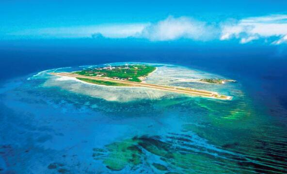
Coral reefs over the Nansha Islands have characteristic geomorphological patterns; they exist in the form of atolls. The Niu’e (also known as Mckennan) and Ximen (Whitsum) reefs of the Jiuzhang Giant Atoll are two secondary atolls with newly-formed debris deposits, which may represent an important stage of landform evolution from a submerged atoll towards a reef island. Grain-size analysis of the surficial sediment samples collected from the two reefs shows that gravel-sized coral debris is the main component of the deposit. Medium grain sizes of the samples (measured by the long axis) range from 14 to 45 mm. Sorting coefficients range from 4.5 (being poorly sorted) to 31 with a sphericity value of 0.52 to 0.68 (far from a sphere shape). Medium grain sizes show a trend of increasing away from the shoreline. Medium grain sizes of the sediment samples are positively correlated with sorting coefficients, whereas they are more or less negatively correlated with sphericity values. Based on an analysis of historical records and satellite images, these beach ridge- or sand bar-like deposits represent modern accumulation landforms; their formations are related to storm waves and to some extent to the winter monsoon waves. The sand bar on the Niu’e reef had been extending towards the southeast and at the same time moving towards the north. The sand bar on the Ximen reef had an overall migration towards the southeast, with recurved sand spits on both sides. The mechanisms for the formulation of these features, in terms of changes in coral material supply and storm wave pattern, need further investigations.
A conid species, Conus ferrugineus Hwass in Bruguière, 1792, was recorded from China for the first time based on specimens deposited in the Marine Biodiversity Collections of the South China Sea, Chinese Academy of Sciences, and on samples recently collected from voyages to the South China Sea. The specimens were collected from the Xisha Islands. The shell morphological features of this species were presented, as well as its habitat and distribution. C. ferrugineus is easily confused with its sympatric sibling species C. vitulinus Hwass in Bruguière, 1792. The most remarkable difference is its uniformly white aperture, in contrast to the violet to violet brown base of the aperture in C. vitulinus. The identification characteristics between them were also discussed and summarized in this paper.
In situ hydrographic data of sea surface salinity (SSS) revealed a freshening trend in the northern South China Sea (SCS) during 2004—2012, which was the freshest in 2012. Such freshening was also found in the UK Met Office EN4 objective analysis product and the ocean general circulation model for the Earth Simulator (OFES) output during 1993-2014, particularly west of Luzon Island and in the southeastern SCS. The salinity budget analysis in the upper layer indicated that the fresh water forcing and horizontal salinity advection contributed to the trends of SSS west of Luzon Island and in the western SCS, respectively. The excessive precipitation in summer accounted for the decrease of SSS to a great extent west of Luzon Island, which was associated with the strengthening trend of the Walker Circulation.
Cold-water corals, also known as deep-water corals, are newly found ecological resources with high biological diversity and attract scientific research on environmental changes. In this study, we investigated cold-water corals retrieved from the cold seep area in the northern South China Sea. We identified two species (Crispatotrochus sp.1, Crispatotrochus sp.2) and four genera [Balanophyllia (Balanophyllia), Balanophyllia (Eupsammia), Lochmaeotrochus, and Enallopsammia]. Stable carbon and oxygen isotopic analyses revealed that the δ13C and δ18O of cold-water corals were -7.36‰ ~ -1.15‰ and -1.38‰ ~ 3.67‰, respectively. The δ13C and δ18O results were close to the carbon and oxygen isotopic values of cold-water corals in other parts of the world, but were quite different from those of warm-water corals, cold-seep carbonate rocks and low-temperature hydrothermal carbonate rocks. This research discovered cold-water corals in a cold seep region of the northern South China Sea. This discovery is important for the studies on environmental effects of deep-water currents and of cold springs in the region.
There are many islands and reefs associated with abundant fishery resources in the South China Sea (SCS). Ecological variables such as chlorophyll in these regions were seldom studied. In this paper, merged ocean color data in recent ~20 years are used to analyze the spatial, seasonal and interannual variations of sea surface chlorophyll concentration (CHL) around 38 islands and reefs in the SCS. The results show that CHL is relatively high around these islands and reefs, which is generally reduced to the background level at five equivalent radii from the island center. The CHL anomaly (relative to the background CHL) is consistent with background CHL in terms of spatial distribution. They are relatively high in Xisha and Dongsha regions, and relatively low in Zhongsha and Nansha regions, mainly due to differences in temperatures and monsoon intensities. The CHL has significant seasonal and interannual variations. It rises during the winter monsoon and falls to a minimum before the summer monsoon onset. It declines in the following years of El Ni?o, when the SST increases and the monsoon weaken; and the opposite happens in the following years of La Ni?a. Moreover, the CHL anomaly increases in spring and autumn seasons when the coral reef community is growing vigorously in Xisha and Dongsha regions. It decreased significantly (P=5.05×10 -5) during the last 20 years, probably due to the increases in sea surface temperature and its amplitude. These findings provide useful information for the development and management of fishery resources in the SCS.
We investigate submesoscale characteristics of summer upwelling fronts in the western South China Sea (WSCS) and associated ageostrophic processes by using satellite measurements and high-resolution ROMS simulations. Active submesoscale filaments with a typical horizontal scale of O(1-10) km are detected to be characterized by O(1) Rossby number (Ro) from the fine-resolution satellite images and simulation results. The diagnostic analysis shows that down-front wind forcing drives a net cross-front Ekman transport and advects heavy water over light water. This process at submesoscale tends to reduce the stratification and potential vorticity (PV), exacerbates the frontal instabilities, and forms the cross-front secondary circulation. The high-resolution simulation results show that the maximum vertical velocity in the frontal zone can reach 100m?d -1, which significantly enhances vertical material exchange. In this context, active submesoscale processes may contribute to enhanced vertical exchanges of the upper ocean in the summer upwelling front of the western SCS.
In this paper, we review latest research on the Zhongnan-Liyue Fault Zone (ZLFZ), and then analyze the spatial distribution and tectonic deformation feature of the ZLFZ based on the geophysical data including topographic, seismic, gravity, and magnetic data. The results show that the ZLFZ in the South China Sea Basin has obvious north-south segmentation characteristics. The north section, which is between northwest sub-basin and east sub-basin, is a NNW trend narrow zone with a width of ~16 km from (18°00'N, 115°30'E) to (17°30'N, 116°30'E). The south section, which is between southwest sub-basin and east sub-basin, is a NNW trend wide zone with a width of 60~80 km from the east of the Zhongsha Bank to the west of the Liyue Bank. The main fault of the ZLFZ is NNW trend along the seamounts’ ridge of Zhongnan. The ZLFZ of transition region is NNE trend from the north section to the south section. On the eastern and western sides of the ZLFZ, the sub-basin’s sedimentary thickness and oceanic crust thickness are obviously different. We speculate that the ZLFZ plays an important role in the geological structure of sub-basin. According to the change of crustal structure, we suspect that the ZLFZ is at least a crustal fracture zone.
Chlorophyll a (Chla) concentration is an important indicator of phytoplankton biomass for estimating primary production, which exhibits inhomogeneous vertical distribution. In this study, optical measurements with high vertical resolution were used for studying the spatio-temporal variability of Chla profiles and its influencing mechanism, providing us much insights for understanding marine environmental dynamics in the South China Sea. In this study, an optical inversion method was proposed to retrieve Chla profiles from in situ measurements with high-spectral absorption/attenuation spectrophotometer in the northeastern South China Sea. Based on the in situ data of the Kuroshio Cruise in summer 2015, an empirical relationship between the absorption line height at 676 nm and Chla was developed for inverting Chla with a high accuracy (Chla=49.96×(aLH(676) (676))0.9339, the coefficient of determination R2=0.87, the root mean square error RMSE=0.16 mg·m-3). Moreover, the response characteristics of Chla profiles to different hydrodynamic processes were studied. Results showed that large spatial differences existed in the vertical distribution of Chla. In the nearshore area, surface Chla varied from 0.42 to 1.57 mg·m-3, which generally followed a decreasing trend with depth. Uniform vertical distribution of Chla in upper ocean was observed in the coastal upwelling region. The Subsurface Chlorophyll Maximum (SCM) layer is nearly ubiquitous in stratified waters of the open ocean, with its vertical structure being influenced by mesoscale processes. The depth of SCM ranged between 34 and 100 m, which showed consistent variability with the isopycnal depth of 1023 kg·m-3. The SCM layer was uplifted to about 34 m due to the mixing effect in the upper ocean caused by Kuroshio intrusion in the western area of Luzon Island. The uplifting and widening of the SCM layer were also observed in the area affected by a cold eddy, with obviously different features in the eddy center from that on the eddy edge.
Oithona is one of the most abundant species of small and medium zooplankton in the ocean, and plays an important role in marine biogeographic genetics and ecology research. In this study, we employed 28S rDNA to analyze the population genetic structure and haplotype pattern of the most common species (Oithona setigera) in the South China Sea. A dataset of 792 bp in length sequences was obtained. The average contents of G+C (58.2%) were significantly higher than those of A+T (41.8%) in the fragment. A total of 28 haplotypes were defined from 186 individuals, of which the dominant haplotype H10 was found in 21 populations. The largest distance between two sampling sites harboring this haplotype is more than 1000 km, indicating Oithona setigera can achieve long distance disperse and be affected by ocean currents. The Mantel test showed that there was no linear correlation between the genetic distance and geographical distance (R= -0.04615, P=0.678); the RDA (redundancy analysis) results indicated space factor significantly affect the population genetic structure rather than environmental factors. The population genetic structure of Oithona setigera may be caused by colonization events followed by demographic expansions.
Mesoscale energy can be effectively extracted from geostrophic flows via sub-mesoscale processes and forward cascade to smaller dissipation scales. These ubiquitous sub-mesoscale processes in the upper ocean play an important role in the transport of mass and energy, mesoscale variability and re-stratification of mixed layer. Using the high-resolution (500-m) ROMS results, we preliminarily analyze the sub-mesoscale dynamic processes of typical anticyclonic eddy in the northern South China Sea in winter. Our results show that the strong lateral buoyancy gradient at eddy periphery can efficiently reduce the Ertel potential vorticity of the front, which exacerbates frontal instabilities and is favorable for the development of symmetric instability (SI). In this case, one of the most important mechanisms is the frontogenesis for the generation of frontal SI. Furthermore, sub-mesoscale processes and associated instabilities can trigger a strong vertical secondary circulation across the front. The vertical velocity is up to 95 m·d-1, suggesting significant vertical exchanges of mass and energy in the mixed layer.
The shallow gas reservoir in the northern deep water area of the South China Sea (SCS) is a new type of oil-gas reservoir associated with gas hydrate, which has the characteristics of shallow burial and large scale, and its burial depth is generally less than 300 m. The shallow gas reservoir was formed by the gas hydrate cap in the deep cracking gas along the fault, and the identification of bottom simulating reflector is an effective method to find the shallow gas reservoir. The gas sources mainly include: pyrolysis gas, biogas and mixture. Slope tensile rupture is a major channel for gas migration, a sand layer at the bottom of the hydrate is the main reservoir of shallow gas accumulation, and the hydrate layer is blocked. Looking from gas hydrate distribution characteristics found in the SCS, shallow gas reservoir, widely distributed in slope deep-water area, with big reservoir thickness, and potentially significant resources, is a new type of reservoir while mining costs are relatively low.
Using remote sensing to accurately estimate phytoplankton absorption coefficient aph(l) can provide basic data and useful method to distinguish different functions of phytoplankton species for long time and large spatial scale. In this paper, the characteristics of aph(l) spectral are compared and analyzed in four typical areas of the South China Sea (SCS), east area of Qiongdong (QD), Guangdong Coastal area (GD), and the Pearl River Estuary (PE) by using field data collected during2003-2012.Then, the phytoplankton population structure differences are preliminarily identified. Furthermore, the performances of MODIS-Aqua aph(l) products derived from the semi-analytical algorithm QAA and empirical algorithm PL by using MODIS-Aqua remote sensing reflectance Rrs(l) products are compared in the SCS and QD waters based on the relaxed match-ups between MODIS-Aqua products and field data. The results show the differences of aph(l) spectral features are obvious among the clear water represented by the SCS and QD and turbid waters represented by GD and PE. In the clear waters, the aph(l) value is small but in a dominant position of particle absorption, while in the GD and PE areas, the aph(l) value is relatively large but not in a dominant position. The aph(l) coefficient have obvious spatial differences, and the possible causes are pigment packaging effect and the variation of pigment composition and concentration. MODIS-Aqua aph(l) products derived from the empirical algorithm PL perform better than those from the semi-analytical algorithm QAA. The algorithm QAA-derived aph(l) products underestimate the results compared to the field data, while the algorithm PL overestimate the results, with the average relative error (APD)less than 22% for both algorithms. There is a great improvement in the accuracy of the PL algorithm by using the Chl-a products derived from the optimized algorithm of OCI (named algorithm NOCI), with the APD less than 14%. In summary, there are strong application prospects to discuss different functions of ocean phytoplankton species by using remote sensing products.
The effect of microorganisms on coral skeletons is more concealed than that by macro-bioerosion, which is visible to the naked eye. The study of micro-bioerosion is rare, and there is no such research in China. In this study, micro-bioerosion research was carried out under scanning electron microscopy on the coral skeletons of the Porites samples collected from Weizhou Island, Daya Bay and Chenhang Island. The “Orange Bands” were formed by microorganisms in the coral skeletons of Weizhou Island and Daya Bay, while there were no similar bands in the samples of Chenhang Island. This phenomenon may be related to the eutrophication of local sea water. Scanning electron microscopy of these "Orange Bands" revealed that this was caused by an endolithic algae—Ostreobium quekettii, a common eroding microorganism in the tropical coral reef area. The structure of Porites skeleton eroded by Ostreobium quekettii is destroyed, the thickness is reduced, the porosity is increased from 1.54% to 6.76%, and the compressive strength is reduced from 27.1% to 51.2%. The microorganism makes the coral skeleton more "loose" and form a layer of "osteoporosis" on the entire surface of the coral. This microorganism acts as a “forerunner,” making corals more susceptible to macro-bioerosion, which in turn promote micro-bioerosion. The “positive feedback effect” explains the increased bioerosion of the coral skeleton in the eutrophic northern South China Sea.
Well LF14, drilled in the Lufeng Sag of the northern South China Sea, discloses marine sediment archives ranging from the mid-to-late period of the early Miocene to the early Pliocene. An abrupt rise in paleo-water depth up to 275 m during the early Miocene is recorded at the lowermost part of the well, followed by several fluctuations thereafter. The early Miocene to early Pliocene deposits are interpreted as formed under middle-to-outer shelf environment, and five complete transgressive-regressive sea-level cycles are identified. The results of backstripping calculations indicate a rapid subsidence in the study area during 17.5-10 Ma. The high sedimentation rate in this period may be caused by rapid tectonic subsidence and high terrigenous input. The subsidence rate was low from 10 to 4.53 Ma, characterized by a low sedimentation rate mainly due to less supply of terrigenous materials and less accommodation space caused by the Dongsha Movement. Finally, several short-lived uplift events were identified in the well based on quantitative reconstruction of paleo-water depth.
The South China Sea is the largest marginal sea in the northwestern Pacific and the key channel connecting the North Pacific and northern Indian Ocean. When the Kuroshio flows northward along the Philippine Islands, signals from the western Pacific are transmitted to the South China Sea through the Luzon Strait, thus affecting the hydrodynamic environment of the South China Sea. We analyze the spatial distribution and low-frequency variability of subsurface salinity in the South China Sea, and try to explain the relationship between the subsurface salinity in the South China Sea and the Pacific Decadal Oscillation (PDO); we also explore the change of the subsurface salinity in recent years. The results are as follows. 1) Driven by the subsurface cyclonic circulation, subsurface salinity at about 24-26 σθ decreases gradually from north to south counterclockwise starting from the Luzon Strait. 2) The low-frequency variability of subsurface salinity is significantly correlated with PDO. When the PDO is in the positive phase, the westward transport in the Luzon Strait is strengthened and the subsurface salinity increases. When the PDO is in the negative phase, the westward transport in the Luzon Strait is weakened and the subsurface salinity decreases, and the salinity change is directly affected by the horizontal circulation. 3) In recent years, the subsurface salinity has shown a trend of refreshing from 2006 to early 2014, and then increasing from 2014 to early 2017, lagging behind the PDO by about 10 months. Since 2017, the salinity decreased again.
Dongsha area is a critical gas hydrate area of the northern South China Sea, and a submarine slide is extensively developed on its slope. In this paper, we analyzed the sedimentological particle size, species characteristic and stable isotope of benthic foraminifera in the cores 973-4 and 973-5, respectively, recovered from the middle of the slope and the flat area at the base. The results of the distinctly negative δ13C values and the heavier δ18O values in both cores in the Last Glacial period suggested that there were persistent gas hydrate dissociation events in the Dongsha area during this period. The δ13C negative gradually disappeared and the δ18O values decreased since the Last Deglacial period, indicating that gas hydrate dissociation was prevented because of global sea level rise. In the core 974, obvious submarine slide deposits only occurred in 440~600 cm according to the Last Glacial Maximum and the number of Uvigerina spp. and Bulimina spp. sharply increased in this location, which implied the submarine slide was probably caused by an intense methane release event induced by the descending sea level in the Last Glacial Maximum period. A smaller scale submarine slide was also recorded in core 973-5, but the deposition time was later than that of core 973-4.
For deep understanding of the evolution of a fault in the passive continental margin slope, we analyzed the characteristics of fault activities and sedimentary response on the northern slope of the Baiyun Sag in this paper. Based on geological structural interpretation of 3D seismic profiles, fault activities were studied by using growth index. The results showed that the fault strike mainly is NWW-trending, while the rest are NEE- to EW-trending of small faults in the eastern and northern slope zones of the Baiyun Sag. In the vertical sections, these faults exhibited ladder and conjugated shaped combinations, while a single fault may be of planar shape. There were three episodes of post-rift fault activities, namely, 23.03-21 Ma, 19.1-15.97 Ma and 10-2.59 Ma. There has been a significant increasing activity since 10 Ma. The study of faults’ orientation indicates that Cenozoic stress field rotated clockwise from NS to NNE and the deflection angle is about 8 degrees. The main controlling factor of fault activities on the northern slope zone of the Baiyun Sag was the continuing strong abnormal subsidence and rapid sedimentation, while the rifting of the South China Sea was also an important factor that formed weak compressive stress on the northern margin; and the convergence between South China Sea plate and Philippine Sea plate played a key role in faults’ reactivation. Sedimentary units responded to tectonic movements directly in a series of deformation. The Dongsha Event was most obvious by canyon incisions, strata truncation and fault reactivation. We suggest the driving force came from the east.
In this study, the vertical characteristics of near-inertial oscillations (NIOs) induced by Typhoon Kalmaegi are analyzed by using data from two moorings about 20 km apart in the northeastern South China Sea in Sept. 2014. The results show that the energy of typhoon-induced NIOs, which propagates downward into the ocean interior, increases with depth in the upper layer and becomes maximum in the mid layer before dissipating with depth. However, we find that there is a large difference in vertical characteristics of typhoon-induced NIOs between the two moorings. The NIOs at mooring A had three different vertical phase velocities at different depths while the NIOs at mooring B showed invariable phase velocity. The value and depth of the maximum near-inertial kinetic energy (NIKE) are also different at the two moorings. The maximum NIKE was 15% greater at mooring B than at mooring A. After the passage of Kalmaegi, fD2 via nonlinear wave interaction between f and D2 occurred at the two moorings, except that the intensities of fD2 at the two moorings were different. At mooring A, fD2 changed with depth and its interaction between f and D2 was weak. The energy of fD2 at mooring B enhanced at the full depth, and the kinetic energy and velocities of fD2 and f had a good correlation for their time-space distributions and variations. The difference of vertical phase velocity of NIOs and fD2 at the two moorings may be caused by the effects of eddy and different stratifications.
A coupled physical-biological 3D model was established, which is forced by realistic forcing, to quantify the effects and underlying mechanisms of upwelling and river plume on the spatial distribution of phytoplankton biomass during summer in the northern South China sea (NSCS). The model was validated by using cruise data of 2006 and 2008 and remote-sensing observations from 2006 to 2008. The results suggest that the model satisfactorily captures the processes of coastal upwelling and river plume dynamics that determine phytoplankton distribution. Model results indicate that summer phytoplankton in the NSCS were mainly distributed within 50m isobath. In Qiongdong and Shantou, phytoplankton distributed evenly. Upwelling processes accounted for up to 90% of the biomass, and horizontal advection in the upper layer was the main sink, while biological processes were the main sources for the phytoplankton biomass. In the Pearl River and Shanwei, phytoplankton shows surface and subsurface maxima: the river plume contributed 35%~40% (mainly to the upper layer) of the phytoplankton biomass, and upwelling contributed 60%~65% (mainly to the middle and bottom layers). In Yuexi, the phytoplankton biomass was extremely low in the upper layer, and mainly distributed in the middle and bottom layers; in total, upwelling contributed 92% of phytoplankton biomass. In the NSCS, both upwelling and river plume processes stimulated phytoplankton through nutrient supply. In the upwelling process, nutrient supply reflected the combination of along- and across-shore nutrient transports. The thermocline, which alters vertical nutrient transfer, is the key factor affecting the variable contributions of upwelling and river plume processes for phytoplankton in different layers. Overall, the spatial variation of summer phytoplankton is mainly driven by upwelling and river plume processes, and by the circulation-nutrient-biological coupling effect.
Driven by the southwest monsoon, an offshore jet is usually formed in the western South China Sea (SCS) and sandwiched by a cyclonic eddy in the north and an anticyclonic eddy in the south, which affects the ecosystem of the region. Using in-situ and satellite data in September 2014, we analyzed the impact of this jet with two eddies on phytoplankton size structure in this region. The data showed that picophytoplankton (0.2~2 µm) dominated the surface, averaged at 76.7% of the total chlorophyll. The contributions of nanophytoplankton (2~20 µm) and microphytoplankton(20~200 µm)in the jet area were respectively higher, and had a positive relationship with the total chlorophyll. Comparatively higher percentage of microphytoplankton appeared in the anticyclonic eddy at surface (average 10.3%) than in the cyclonic eddy (average 3.6%). The results suggested that physical processes significantly influenced summertime surface phytoplankton size structure in the western South China Sea. Both the jet and eddies can affect phytoplankton size structure by increasing the contribution of microphytoplankton. Surface horizontal advection of phytoplankton by the northeastward jet formed the coastal upwelling area and was the main source of microphytoplankton in the open sea. The interactions of convergence and divergence in the eddies with the jet formed a chlorophyll front and increased the microphytoplankton component. Upwelling in the center of the cyclonic eddy brought up nutrients, which increased the percentage of the microphytoplankton component.
The third scientific drilling in the South China Sea (SCS) will be carried out during Feb. to Jun. 2017 under the system of the International Ocean Discovery Program (IODP), namely, IODP Legs 367 and 368. The drilling project will improve the research on geology and geophysics of the SCS and bring it to an unprecedented stage. The combination of Ocean Bottom Seismometers (OBS) deep seismic survey with IODP drilling data will improve drilling achievement, and contribute greatly to our understanding of the specific mechanism of rifting and breakup processes in the northern SCS. We first built three original velocity models based on the three geological presumptions of IODP Legs 367 and 368 as follows. 1) the exhumed lower crust, 2) the oldest oceanic crust and 3) the exhumed upper mantle. Second, the ray-tracing and travel-time modelling were performed for different OBS intervals with employment of Rayinvr and Tomo2d software, as well as check-board tests for the models. The testing results suggest that the ray-tracing paths and ray density with the 7 km interval of OBS stations are better than those with the 10 km interval. However, the seismic survey line is 100 km, enough in length to make sure to detect the crustal structure at 30 km depth. And the results of check-board tests show that the 7 km interval of OBS stations is necessary to difference the 20-km-in-size velocity anomaly, which is the uncertainty zone in the seismic profile. The design analysis on the optimal deployment scheme of OBS stations will not only provide a good suggestion for the design of future seismic survey, but also contribute to our understanding of the mechanism of rifting and breakup processes in the SCS.
Summer (from June to September) time series of 15 years (2002-2016) of chlorophyll-a (Chl a) from the Moderate Resolution Imaging Spectroradiometer (MODIS) Aqua products were collected to discuss seasonal and interannual variability of ecological response of the Pearl River Plume in the Northern South China Sea (NSCS). In June, under the influence of southwest monsoon, nutrients from the Pearl River Delta were transported eastward to the shelf area, phytoplankton bloomed and Chla increased. The coverage area over the shelf in the NSCS reached the maximum in July, and decreased in August when the river discharge and wind reduced. In September when the northeasterly wind prevailed in the NSCS, the coverage area with high concentration of Chla (AHCHL) west of the estuary increased. Linear regression analysis suggested that the river discharge was the main reason for driving the AHCHL variability with a time lag of about one month. The combined effect of stronger (weaker) than the multi-year mean river discharge and wind resulted in extremely large (small) AHCHL in 2008 (2004). Because the spatiotemporal variability of Chl a in the NSCS was mainly influenced by the Pearl River Plume, the quality controlled satellite Chl a products can be used to discuss the variability of the Pearl River Plume.
Marine planktonic ostracods are small crustaceans with a wide distribution, playing an important role in ocean carbon cycle. The ostracods in smaller size are usually underestimated when marine zooplankton samples were collected with 505 μm mesh. Based on the zooplankton samples collected with 505 and 160 μm meshes in the northern South China Sea from July to August 2006 (summer) and from December 2006 to January 2007 (winter), the capture efficiency for the ostracods using two planktonic mesh sizes was compared, and the community structure and the influence of environmental factors on their distributions were analyzed. We found that the abundance of ostracods obtained by the 160 μm mesh net was six times that by the 505 μm net in summer. The community structure of planktonic ostracods collected by the 160 μm mesh was analyzed with the following findings. 1) The species richness of planktonic ostracods of a total of 32 species was identified to increase from nearshore to offshore, and the difference between the areas with water depth shallower and deeper than 100 m was extremely significant (p<0.01). 2) The abundance of planktonic ostracods was higher in summer, when the high abundance area appeared mainly in the coastal waters of the Leizhou Peninsula and northeast Hainan Island higher than that in offshore significantly (p<0.05), and lower in winter, when the distribution of ostracods abundance was homogeneous. 3) Euconchoecia aculeata, dominant species, contributed the most to high abundance in the nearshore. 4) The species richness of ostracods was positively correlated with temperature and water depth; and the abundance was negatively correlated with temperature and salinity, and positively correlated with chlorophyll α concentration. Qiongdong coastal upwelling and Yuexi Coastal Current boosted the abundance of planktonic ostracods up to 1252 ind·m -3 in the coastal waters of the Leizhou Peninsula and northeast Hainan Island. Results suggest that smaller mesh net should be used for the overall assessment of community characteristics of planktonic ostracods.
Recent investigations of the ultraslow-spreading (full spreading rate: 12~18mm#cod#x000b7;yr-1) Southwest Indian Ridge revealed two kinds of crustal structure: Magmatic and amagmatic accretionary crust. Magmatic accretionary segments appear as the axial rise, relatively low mantle Bouguer gravity anomaly, strong magnetization and thick crust. Amagmatic accretionary segments feature detachments and abundant high-angle normal faults, lack of transform faults, deep water, relatively high mantle Bouguer gravity anomaly and weak magnetization. There are also significant amount of serpentinized peridotites exposed on the seafloor, and the igneous crust is thin, even absent. The Southwest Sub-basin of the South China Sea (SWSB) has relatively slow-spreading rates (full spreading rate: 50~35mm#cod#x000b7;yr-1). The central part of SWSB also presents thin crust and there might be some serpentinized peridotites in the basin area, which are similar to the characteristics of the amagmatic accretionary crust in the ultraslow-spreading Southwest Indian Ridge.
The central western South China Sea is one of the main fishing grounds for fishery development. To understand the trophic relationships of major fishery organisms of the central western South China Sea, stable isotope techniques were used to analyze and determine carbon and nitrogen stable isotope ratios of major fishery biological samples in the area. The trophic levels of the main fishery biota were calculated to construct a continuous trophic spectrum of the main fishery organisms in the area. These results show that the major fishery isotope ratios have a wide range of changes in the central western South China Sea. The δ13C and δ15N values of the fish ranged from -20.00‰ to -16.51‰ and from 7.94‰ to 11.81‰, respectively. The δ13C and δ15N values of the cephalopods ranged from -18.84‰ to -17.60‰ and from 10.10‰ to 12.85‰, respectively. The corresponding trophic levels of each species were calculated using zooplankton as the baseline organism. The trophic level of fish ranged from 2.41 to 3.53, and that of cephalopods ranged from 3.03 to 3.84. Among the organisms, the average trophic level of cephalopods is higher than that of fish. Comparison of trophic levels in different lengths (mantle length) of Symplectoteuthis oualaniensis, Thysanoteuthis rhombus, Decapterus russelli, Decapterus lajang, and Thunnus albacares reveals that the trophic level has a correspondingly increasing trend as body length increases. In this study, we preliminarily established the continuous trophic levels’ spectrum of major fishery bio-nutritional levels in the central and western waters of the central western South China Sea, providing a theoretical basis for the food web structure and fishery resource utilization in the area.
Jack mackerel (Trachurus japonicus) is one of the main catches in the northern South China Sea. Based on the survey data of the North China Coastal Fishery Resources Survey (2014-2017) in the South China Sea, we used geostatistics to explore the spatial and temporal distribution characteristics of jack mackerel and related eco-dynamic processes. The results showed that the overall spatial distribution of jack mackerel was mainly associated with low resource density and less high density of resources. The characteristics of seasonal aggregation are obvious and as follows: summer> spring> autumn> winter. We found that the spatial distribution had a strong heterogeneity, and the proportion of spatial structure was above 75%. The spatial variability was dominated by Gaussian distribution, and the spatial correlation distance (variation range) was about 0.52° with obvious seasonal characteristics. Through the research on the correlation between geostatistical parameter values and catch per unit effort (CPUE), we found that the greater the resource density of jack mackerel, the more obvious the spatial heterogeneity was. Through the heterogeneity analysis in all directions, we found that the spatial heterogeneity in the northwest-southeast direction was significant, indicating that the marine dynamic process in this direction had a significant impact on the migration and distribution of jack mackerel. In addition, based on the Kriging interpolation analysis of the spatial distribution of jack mackerel, we found that jack mackerel had a pattern of migratory distribution from southwest to northeast, which had obvious characteristics of patchy distribution. Jack mackerel was also susceptible to extreme climate (El Nino, La Nina, and other extreme events).
Intra-seasonal variability (ISV) of sea level anomalies (SLA) and their propagation features in the northern South China Sea (NSCS) are investigated using 25-year (1993-2017) satellite observations. The standard deviation of intra-seasonal SLA reveals that larger ISV exists in the northeastern South China Sea along the continental shelf/slope (200~2000 m) where it extends southwestward from Taiwan to Hainan. The ISV of SLA exhibits obvious seasonality, being strong in winter and weak in summer. By using Complex Empirical Orthogonal Function (CEOF) analysis, the spatial pattern and temporal variability of the ISV, as well as their inter-annual modulation, are studied. We find that there are mainly two types of ISV pattern, showing great agreement with eddy activities in the NSCS. The ISV of SLA is also modulated by seasonal and inter-annual variation. The first mode of CEOF indicates southwestward propagation of the ISV from southwest of Taiwan to east of the Xisha Islands, being especially strong in winter. The second mode of CEOF reveals two westward ISV regions: southwest to Taiwan and south to the Dongsha Islands. The statistical analysis for the seasonal variation of mesoscale eddies indicates that the CEOF results are consistent with the distribution of mesoscale eddy activities in the NSCS.
Marine ecosystem dynamics model is an important means to study marine ecological environment. As the model complexity increases, the number and uncertainty of biological parameters increase, which has a great impact on model results; therefore, optimization of model parameters is particularly important. In this paper, a one-dimensional physical-biological model is applied to the northern South China Sea, and the key biological parameters obtained through sensitivity analysis are optimized by using genetic algorithm. The results show that the sensitive parameters in the model are related to phytoplankton growth, zooplankton growth, feeding and death, and detritus sinking. Based on the genetic algorithm optimization of the above-mentioned parameters, we find that the surface and vertical simulation errors of the model are reduced by 27.80% and 21.40%, respectively, by using only surface satellite data; the surface and vertical simulation errors are reduced by 14.90% and 32.70%, respectively, by adding observed profile data. The success of applying genetic algorithm in the one-dimensional model provides the basis for its further application in three-dimensional marine ecosystem models.
Our Argo trajectory simulation system for the South China Sea (SCS) contains the high-resolution ambient velocity field, a Lagrangian particle tracking model and the parameterization that represents the vertical motions of profiling Argo floats. This system is applied to simulate both conventional Argo floats (typically parked at 1000 m depth and profiling to 2000 m depth) and Deep Argo floats (parked at 500 m above the seafloor) within the SCS. By conducting the simulation with the counterparts of six core Argo floats serviced in the SCS, we find the displacements of synthetic floats from the simulation system resemble the real float displacements over 100-day time intervals. We therefore judge the simulations for core Argo are robust and further apply the system to simulate a potential Deep Argo array (with the resolution of 2°×2°×30 day). The results explore both the representativeness and the predictability of float displacements, which may provide a basis to understand float displacements in the deep layer as well as to contribute to planning deep Argo array program.