
Journal of Tropical Oceanography ›› 2022, Vol. 41 ›› Issue (2): 52-64.doi: 10.11978/2021072CSTR: 32234.14.2021072
• Marine Physics • Previous Articles Next Articles
Evolution of water level profile dynamics in the Modaomen estuary of the Pearl River and its responses to human activities*
MA Yuting1,2,3,4( ), CAI Huayang1,2,3,4, YANG Hao1,2,3,4, LIU Feng1,2,3,4, CHEN Ou1,2,3,4, XIE Rongyao1,2,3,4, OU Suying1,2,3,4(), YANG Qingshu1,2,3,4
- 1. Institute of Estuarine and Coastal Research, School of Marine Engineering and Technology, Sun Yat-sen University, Guangzhou 510275, China
2. State and Local Joint Engineering Laboratory of Estuarine Hydraulic Technology, Guangzhou 510275, China
3. Guangdong Provincial Engineering Research Center of Coasts, Islands and Reefs, Guangzhou 510275, China
4. Southern Laboratory of Ocean Science and Engineering (Zhuhai), Zhuhai 519000, China
-
Received:2021-06-09Revised:2021-08-05Online:2022-03-10Published:2021-08-16 -
Contact:OU Suying E-mail:mayt8@mail2.sysu.edu.cn;ousuying@mail.sysu.edu.cn -
Supported by:National Key Research and Development Program of China(2016YFC0402600);National Natural Science Foundation of China(41106015);National Natural Science Foundation of China(42076171);National Natural Science Foundation of China(51979296);Science and Technology Planning Project of Guangdong Province, China(202002030452);Water Resource Science and Technology Innovation Program of Guangdong Province(2016-20)
CLC Number:
- P731.23
Cite this article
MA Yuting, CAI Huayang, YANG Hao, LIU Feng, CHEN Ou, XIE Rongyao, OU Suying, YANG Qingshu. Evolution of water level profile dynamics in the Modaomen estuary of the Pearl River and its responses to human activities*[J].Journal of Tropical Oceanography, 2022, 41(2): 52-64.
share this article
Add to citation manager EndNote|Reference Manager|ProCite|BibTeX|RefWorks
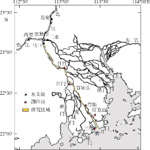
Fig. 1
Map of the study area and the stations used in this study"
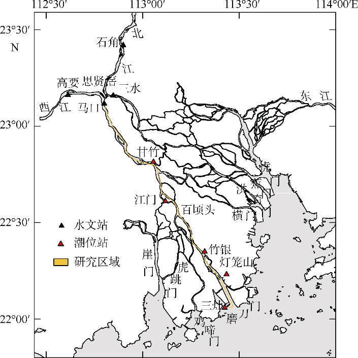
Fig. 1
Fig. 2
Sketch of the residual water level curvature (a) and comparison of fitting methods for water level profiles along the estuary (b)"
Fig. 2
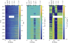
Fig. 3
Evolution of the residual water level (a), residual water level slope (b) and residual water level curvature (c) along the Modaomen estuary"
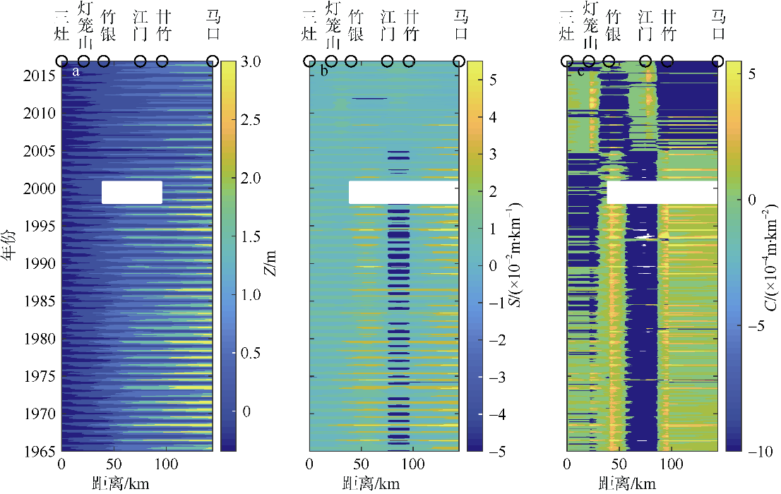
Fig. 3

Fig. 4
Monthly averaged variations in residual water level slope (a~e) and curvature (f~j) in the pre-human period (1965-1990) and post-human period (2001-2016)"
Fig. 4
Tab. 1
Calibration of the bivariate linear regression model with three parameters in the Modaomen estuary"
| 站点 | 缓变阶段 | 调整阶段 | |||||
|---|---|---|---|---|---|---|---|
| α1 | α2 | β | RMSE | R2 | RMSE | R2 | |
| 马口 | 2.78×10⁻⁴ | 0.33 | -0.29 | 0.38 | 0.94 | 0.22 | 0.93 |
| 甘竹 | 1.57×10⁻⁴ | 0.61 | -0.10 | 0.26 | 0.91 | 0.08 | 0.97 |
| 江门 | 1.14×10⁻⁴ | 0.67 | 0.09 | 0.21 | 0.89 | 0.09 | 0.95 |
| 竹银 | 0.46×10⁻⁴ | 0.83 | 0.03 | 0.07 | 0.94 | 0.05 | 0.93 |
| 灯笼山 | 0.19×10⁻⁴ | 0.86 | 0.03 | 0.04 | 0.92 | 0.03 | 0.94 |
Tab. 1
Fig. 5
Calibration of the regression model in the pre-human period (a, c, e, g, i) and reconstruction of the water level in the post-human period (b, d, f, h, j) in the Modaomen estuary"
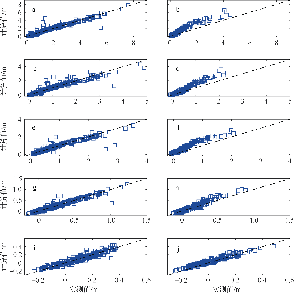
Fig. 5
Fig. 6
Longitudinal variations in the residual water level (a), residual water level slope (b) and the residual water level curvature (c) along the Modaomen estuary"
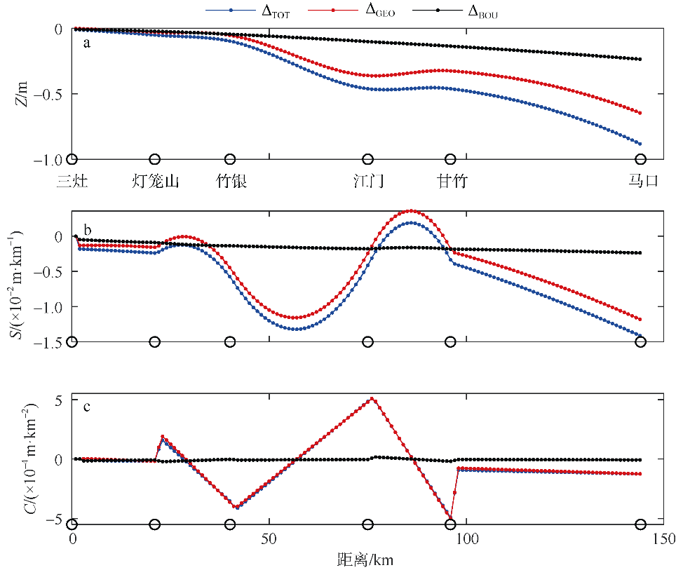
Fig. 6
Tab. 2
Influence of strong human interventions on the residual water level, slope and curvature along the estuary"
| 三灶—灯笼山 | 灯笼山—竹银 | 竹银—江门 | 江门—甘竹 | 甘竹—马口 | ||
|---|---|---|---|---|---|---|
| 余水位/m | △TOT | -0.029 | -0.070 | -0.292 | -0.461 | -0.634 |
| △GEO | -0.015 | -0.036 | -0.219 | -0.341 | -0.450 | |
| △BOU | -0.015 | -0.034 | -0.073 | -0.119 | -0.185 | |
| 余水位坡降/(×10-2m·km-1) | △TOT | -0.198 | -0.245 | -1.039 | 0.001 | -0.876 |
| △GEO | -0.131 | -0.125 | -0.880 | 0.169 | -0.669 | |
| △BOU | -0.068 | -0.120 | -0.160 | -0.167 | -0.207 | |
| 余水位曲率/(×10-4m·km-2) | △TOT | -0.137 | -0.882 | 0.230 | 0.187 | -1.122 |
| △GEO | -0.064 | -0.755 | 0.286 | 0.157 | -1.044 | |
| △BOU | -0.098 | -0.121 | -0.062 | -0.007 | -0.058 | |
Tab. 2
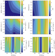
Fig. 7
Contour plot of residual water level (a, b), slope (c, d) and curvature (e, f) as a function of river discharge and downstream water level. The red line is the contour with zero residual water level slope"
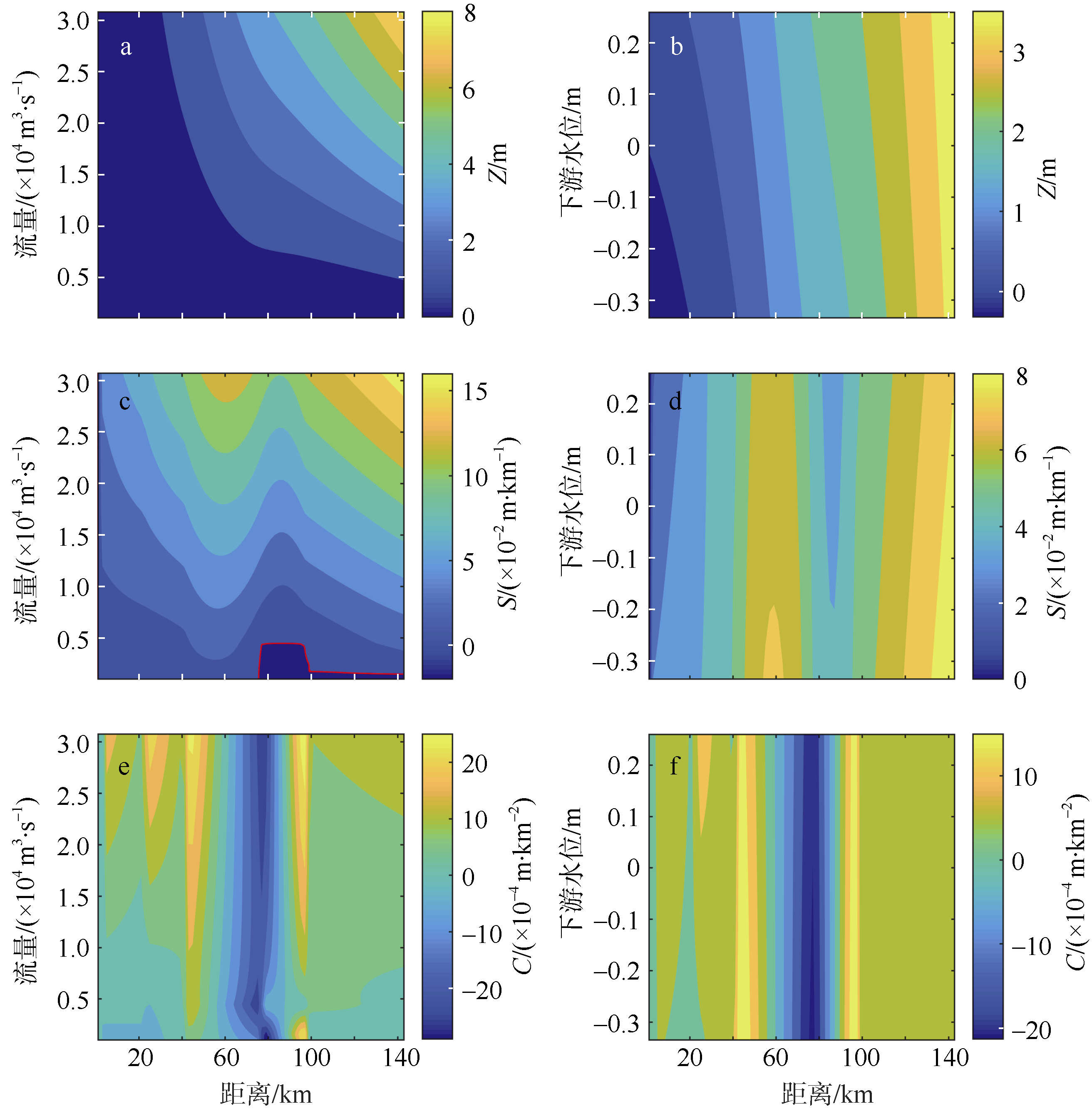
Fig. 7
Tab. 3
Correlation between curvature and tendency of erosion and deposition in different reaches of the Modaomen estuary"
| 年份 | 河段 | 平均水深变化/m | 实测冲淤变化 | 曲率/(×10-4m·km-2) | 动力反演冲淤趋势 |
|---|---|---|---|---|---|
| 1962—1977 | 三灶至灯笼山 | / | / | 0.66 | 淤积 |
| 灯笼山至竹银 | -0.10 | 淤积 | 1.23 | 淤积 | |
| 竹银至百顷头 | -0.25 | 淤积 | 0.26 | 淤积 | |
| 百顷头至甘竹 | 0.11 | 侵蚀下切 | -1.24 | 冲刷 | |
| 甘竹至马口 | 0.22 | 侵蚀下切 | 1.30 | 淤积 | |
| 1977—1999 | 三灶至灯笼山 | / | / | -0.01 | 冲刷 |
| 灯笼山至竹银 | 0.21 | 侵蚀下切 | 0.75 | 淤积 | |
| 竹银至百顷头 | 0.40 | 侵蚀下切 | 0.15 | 淤积 | |
| 百顷头至甘竹 | 0.23 | 侵蚀下切 | -1.47 | 冲刷 | |
| 甘竹至马口 | -0.04 | 微淤 | 1.71 | 淤积 | |
| 1999—2005 | 三灶至灯笼山 | / | / | -0.28 | 冲刷 |
| 灯笼山至竹银 | -0.06 | 微淤 | 0.04 | 淤积 | |
| 竹银至百顷头 | 0.25 | 侵蚀下切 | -0.01 | 冲刷 | |
| 百顷头至甘竹 | 0.46 | 侵蚀下切 | -0.26 | 冲刷 | |
| 甘竹至马口 | 1.06 | 侵蚀下切 | 0.89 | 淤积 | |
| 2005—2013 | 三灶至灯笼山 | / | / | 0.53 | 淤积 |
| 灯笼山至竹银 | 0.72 | 侵蚀下切 | -0.26 | 冲刷 | |
| 竹银至百顷头 | 0.80 | 侵蚀下切 | -0.20 | 冲刷 | |
| 百顷头至甘竹 | -0.02 | 微淤 | 0.11 | 淤积 | |
| 甘竹至马口 | 0.31 | 侵蚀下切 | -0.01 | 冲刷 |
Tab. 3
| [1] | 陈吉余, 程和琴, 戴志军, 2008. 河口过程中第三驱动力的作用和响应--以长江河口为例[J]. 自然科学进展, 18(9): 994-1000. (in Chinese) |
| [2] | 韩志远, 田向平, 欧素英, 2010. 人类活动对磨刀门水道河床地形和潮汐动力的影响[J]. 地理科学, 30(4): 582-587. |
| HAN ZHIYUAN, TIAN XIANGPING, OU SUYING, 2010. Impacts of large-scale human activities on riverbed morphology and tidal dynamics at Modaomen Estuary[J]. Scientia Geographica Sinica, 30(4): 582-587. (in Chinese with English abstract) | |
| [3] | 洪鹏锋, 杜文印, 2019. 强人类活动驱动下珠江磨刀门河口潮汐动力增强原因初探[J]. 人民珠江, 40(9): 28-32. |
| HONG PENGFENG, DU WENYIN, 2019. Preliminary study on the reasons for the enhancement of tide dynamic in Modaomen Estuary of Pearl River driven by strong human activities[J]. Pearl River, 40(9): 28-32. (in Chinese with English abstract) | |
| [4] | 胡煌昊, 徐阳, 官明开, 等, 2016. 珠江河口水下三角洲冲淤演变分析[J]. 水道港口, 37(6): 593-598. |
| HU HUANGHAO, XU YANG, GUAN MINGKAI, et al, 2016. Analysis on morphological evolution of underwater delta in the Pearl River Estuary[J]. Journal of Waterway and Harbor, 37(6): 593-598. (in Chinese with English abstract) | |
| [5] | 黎开志, 周文浩, 钱挹清, 等, 2005. 珠江磨刀门整治效果分析[J]. 人民珠江, (S1): 31-34. (in Chinese) |
| [6] | 刘锋, 田向平, 韩志远, 等, 2011. 近四十年西江磨刀门水道河床演变分析[J]. 泥沙研究, (1): 45-50. |
| LIU FENG, TIAN XIANGPING, HAN ZHIYUAN, et al, 2011. Analysis of river channel evolution of Modaomen Channel of Xijiang River in past forty years[J]. Journal of Sediment Research, (1): 45-50. (in Chinese with English abstract) | |
| [7] | 吕海滨, 吴超羽, 刘斌, 2006. 珠江口磨刀门整治前后水动力数值模拟[J]. 海洋科学, 30(11): 58-63. |
| LÜ HAIBIN, WU CHAOYU, LIU BIN, 2006. Hydrodynamic numerical simulation during the rebuilding of Modaomen Estuary of the Pearl River[J]. Marine Sciences, 30(11): 58-63. (in Chinese with English abstract) | |
| [8] | 倪晋仁, 1990. 关于悬移质输沙率计算模式的探讨[J]. 水利学报, (8): 10-19. |
| NI JINREN, 1990. Calculation models for the suspended sediment transport rate[J]. Journal of Hydraulic Engineering, (8): 10-19. (in Chinese with English abstract) | |
| [9] | 钱挹清, 2004. 珠江三角洲河道无序采沙影响及管理措施[J]. 人民珠江, (2): 44-46, 58. |
| QIAN YIQING, 2004. Effects of disordered sand borrowing in river channels in the Pearl River delta and management measures[J]. Pearl River, (2): 44-46, 58. (in Chinese with English abstract) | |
| [10] | 杨昊, 欧素英, 傅林曦, 等, 2020. 珠江磨刀门河口日均水位变化及影响因子辨识[J]. 水利学报, 51(7): 869-881. |
| YANG HAO, OU SUYING, FU LINXI, et al, 2020. Quantifying the impacts of external forcing on daily averaged water levels in the Modaomen Estuary of the Pearl River[J]. Journal of Hydraulic Engineering, 51(7): 869-881. (in Chinese with English abstract) | |
| [11] | 袁建国, 廖志伟, 2009. 珠江河口综合治理概述[J]. 人民珠江, 30(S2): 13-14, 18. |
| YUAN JIANGUO, LIAO ZHIWEI, 2009. Summary of Pearl River estuary comprehensive regulation[J]. Pearl River, 30(S2): 13-14, 18. (in Chinese with English abstract) | |
| [12] | 张红武, 张俊华, 卜海磊, 等, 2011. 试论推移质输沙率公式[J]. 南水北调与水利科技, 9(6): 140-145. |
| ZHANG HONGWU, ZHANG JUNHUA, BU HAILEI, et al, 2011. Discussion of bed-load transport equations[J]. South-to-North Water Transfers and Water Science & Technology, 9(6): 140-145. (in Chinese with English abstract) | |
| [13] | 张先毅, 黄竞争, 杨昊, 等, 2019. 长江河口潮波传播机制及阈值效应分析[J]. 海洋与湖沼, 50(4): 788-798. |
| ZHANG XIANYI, HUANG JINGZHENG, YANG HAO, et al, 2019. The governing mechanism of tidal wave propagation and threshold effect in the Changjiang River Estuary[J]. Oceanologia et Limnologia Sinica, 50(4): 788-798. (in Chinese with English abstract) | |
| [14] | 张先毅, 杨昊, 黄竞争, 等, 2020. 强人类活动驱动下珠江磨刀门河口径潮动力的季节性异变特征[J]. 海洋与湖沼, 51(5): 1043-1054. |
| ZHANG XIANYI, YANG HAO, HUANG JINGZHENG, et al, 2020. Impact of intensive human activity on seasonal variation in river-tide dynamics in the Modaomen Estuary of Zhujiang (Pearl) River[J]. Oceanologia et Limnologia Sinica, 51(5): 1043-1054. (in Chinese with English abstract) | |
| [15] | 张子昊, 2018. 人类活动影响下珠江网河河道演变与机制[D]. 广州: 中山大学: 55-61. |
| ZHANG ZHIHAO, 2018. Evolution of the River Channel and its Mechanism in Response to Diverse Human Activities in the Pearl River Network[D]. Guangzhou: Sun Yat-sen University: 55-61. (in Chinese with English abstract) | |
| [16] | 郑国栋, 2005. 人类活动对珠江三角洲水动力环境影响研究[D]. 武汉: 武汉大学: 87-97. |
| ZHENG GUODONG, 2005. Research of the human activity impact on hydrodynamic environment in pearl river delta[D]. Wuhan: Wuhan University: 87-97. (in Chinese with English abstract) | |
| [17] | 邹志利, 2009. 海岸动力学[M]//邹志利. 沙质海岸泥沙运动. 4版. 北京: 人民交通出版社: 159-176. (in Chinese) |
| [18] | BUSCHMAN F A, HOITINK A J F, VAN DER VEGT M, et al, 2009. Subtidal water level variation controlled by river flow and tides[J]. Water Resources Research, 45(10): W10420. |
| [19] |
CAI H, SAVENIJE H H G, JIANG C, 2014. Analytical approach for predicting fresh water discharge in an estuary based on tidal water level observations[J]. Hydrology and Earth System Sciences, 18(10): 4153-4168.
doi: 10.5194/hess-18-4153-2014 |
| [20] | CAI HUAYANG, SAVENIJE H H G, TOFFOLON M, 2013. Linking the river to the estuary: influence of river discharge on tidal damping[J]. Hydrology and Earth System Sciences Discussions, 10(7): 9191-9238. |
| [21] | CAI HUAYANG, SAVENIJE H H G, JIANG CHENJUAN, et al, 2015. Analytical approach for determining the mean water level profile in an estuary with substantial fresh water discharge[J]. Hydrology and Earth System Sciences Discussions, 12(8): 8381-8417. |
| [22] | CAI HUAYANG, YANG HAO, LIU JUNYONG, et al, 2019. Quantifying the impacts of human interventions on relative mean sea level change in the Pearl River Delta, China[J]. Ocean & Coastal Management, 173: 52-64. |
| [23] |
HOITINK A J F, JAY D A, 2016. Tidal river dynamics: implications for deltas[J]. Reviews of Geophysics, 54(1): 240-272.
doi: 10.1002/rog.v54.1 |
| [24] | LAMB M P, NITTROUER J A, MOHRIG D, et al, 2012. Backwater and river plume controls on scour upstream of river mouths: implications for fluvio-deltaic morphodynamics[J]. Journal of Geophysical Research, 117(F1): 117. |
| [25] |
LIU FENG, XIE RONGYAO, LUO XIANGXIN, et al, 2019. Stepwise adjustment of deltaic channels in response to human interventions and its hydrological implications for sustainable water managements in the Pearl River Delta, China[J]. Journal of Hydrology, 573: 194-206.
doi: 10.1016/j.jhydrol.2019.03.063 |
| [26] |
YANG HAO, ZHANG XIANYI, CAI HUAYANG, et al, 2020. Seasonal changes in river-tide dynamics in a highly human-modified estuary: modaomen Estuary case study[J]. Marine Geology, 427: 106273.
doi: 10.1016/j.margeo.2020.106273 |
| [1] | XU Jie, GUO Jibing, CHEN Zhiqiang, ZHU Zhihui, WANG Qin, TANG Yanling. Comparative study on the contribution of various influential factors and characteristics analysis of an extra-tropical storm surge caused by cold front in the Yangshan Port and its adjacent area [J]. Journal of Tropical Oceanography, 2022, 41(4): 126-135. |
| [2] | SUN Fenglin. Disaster loss assessment of storm surge based on Dempster-Shafer theory of evidence [J]. Journal of Tropical Oceanography, 2022, 41(1): 75-81. |
| [3] | XIE Meifang, ZHANG Ping, YANG Hao, FU Linxi, WANG Heng, CAI Huayang, YANG Qingshu. Tidal wave propagation dynamics in Lingdingyang Bay-Humen outlet-tidal channel of the Pearl River [J]. Journal of Tropical Oceanography, 2021, 40(4): 1-13. |
| [4] | ZHOU Xuan, LI Ziqiang, AN Yuzhu, ZHANG Yaowen, YANG Xiaofeng. Surface current characteristics in the central eastern sea area of Hainan Island detected by high-frequency surface wave radar [J]. Journal of Tropical Oceanography, 2021, 40(2): 103-111. |
| [5] | JIANG Chenjuan, ZHOU Jianan, YANG Qingshu. Effects of human intervention on tidal dynamics in the Modaomen Estuary, Pearl River [J]. Journal of Tropical Oceanography, 2020, 39(6): 66-76. |
| [6] | TONG Chaofeng, SI Jialin, ZHANG Wei, GAO Xiangyu. Analysis of tidal wave propagation distortion and asymmetry in Lingding Bay during wet season [J]. Journal of Tropical Oceanography, 2020, 39(1): 36-52. |
| [7] | Min ZHANG, Jun LUO, Jinlei HU, Xuezhi ZENG. Inundation risk assessment of storm surge along Lei Zhou coastal areas* [J]. Journal of Tropical Oceanography, 2019, 38(2): 1-12. |
| [8] | Huaixin ZHU, Tingting ZU, Jian LI, Yeqiang SHU, Ju CHEN, Dongxiao WANG. Analysis of tidal current and tidal energy on the west coast of Guangdong Province based on High Frequency Ground Wave Radar observation [J]. Journal of Tropical Oceanography, 2018, 37(5): 25-32. |
| [9] | LI Juan, BAI Yiping, ZUO Juncheng, TAN Wei, ZHAO Xue. The influence of melting season of the Greenland ice sheet on the sea level variation during the 21st century [J]. Journal of Tropical Oceanography, 2016, 35(3): 20-29. |
| [10] | ZHU Xue-ming, SONG De-hai, BAO Xian-wen, LIU Gui-mei. Tidal energy flux and dissipation in the Northwest Pacific [J]. Journal of Tropical Oceanography, 2014, 33(1): 1-9. |
| [11] | WANG Kang-fa-sheng,YIN Zhan-e,YIN Jie. Analysis on typhoon-induced storm surge vulnerability of China’s coastal areas on rising sea level background [J]. Journal of Tropical Oceanography, 2011, 30(6): 31-36. |
| [12] | DENG Guotong, LIU Mincong, XING Jiuxing, SHENG Jinyu, ZHOU Kai, CHEN Shengli. Analysis on the influencing factors of storm surges near Shenzhen [J]. Journal of Tropical Oceanography, 2022, 41(3): 91-100. |
|
||