
Journal of Tropical Oceanography ›› 2017, Vol. 36 ›› Issue (2): 70-78.doi: 10.11978/2016064CSTR: 32234.14.2016064
Special Issue: 海洋大数据及应用
• Orginal Article • Previous Articles Next Articles
Retrieval of island shallow water depth from the GaoFen-1 multi-spectral imagery
Benqing CHEN( ), Yanming YANG, Kai LUO
- Third Institute of Oceanography, State Oceanic Administration, Xiamen, 361005, China
-
Received:2016-06-27Revised:2016-11-04Online:2017-03-20Published:2017-04-06 -
Supported by:High Resolution Earth Observation System Special Project (41-Y30B12-9001-14/16);Promote Cross-Taiwan Strait Union Science and Technology Cooperation Fund (U1405234);Scientific Research Foundation of Third Institute of Oceanography, State Oceanic Administration (2014017)
CLC Number:
- P714
Cite this article
Benqing CHEN, Yanming YANG, Kai LUO. Retrieval of island shallow water depth from the GaoFen-1 multi-spectral imagery[J].Journal of Tropical Oceanography, 2017, 36(2): 70-78.
share this article
Add to citation manager EndNote|Reference Manager|ProCite|BibTeX|RefWorks
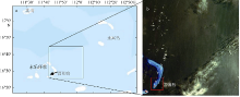
Fig. 1
Location of Jinqing Island (a) and acquired Gaofen-1 satellite image (b). The red box in (b) denotes the study area"

Fig. 1
Tab. 1
Related parameters of Gaofen-1 satellite image"
| 传感器 | 波长/mm | 分辨率/m | 幅宽/km | 自主定位精度 |
|---|---|---|---|---|
| 全色 | 0.45~0.90 | 2.0 | 60 | 优于50m |
| 多光谱 | 蓝波段: 0.45~0.52 绿波段: 0.52~0.59 红波段: 0.63~0.69 近红外波段: 0.77~0.89 | 8.0 | 60 |
Tab. 1
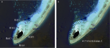
Fig. 2
Reference points (a) and accuracy validation points (b) of water depth"
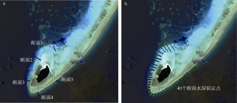
Fig. 2

Fig. 3
Location distribution of two objects for evaluating atmospheric effect of DOS3"
Fig. 3
Fig. 4
Reflectance comparison of two different objects before and after atmospheric correction"
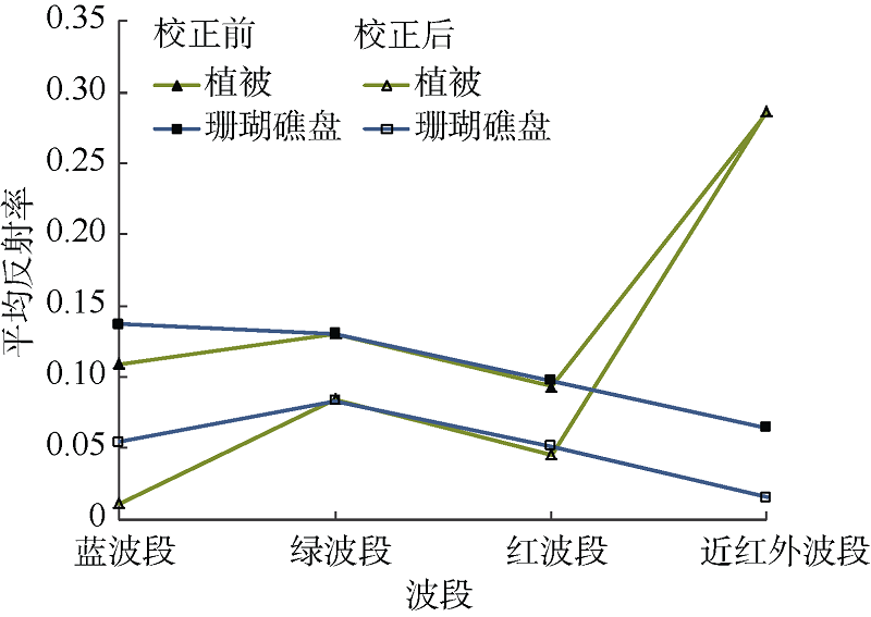
Fig. 4
Tab. 2
Radiance calibration coefficients and solar exoatmospheric irradiances constant of Gaofen-1 satellite"
| 波段 | 增益值/ (W·m-2·Sr-1·µm-1) | 偏移值/ (W·m-2·Sr-1·µm-1) | E0 / (W·m-2) |
|---|---|---|---|
| 蓝波段 | 0.2247 | 0.0 | 1944.98 |
| 绿波段 | 0.1892 | 0.0 | 1854.42 |
| 红波段 | 0.1889 | 0.0 | 1542.63 |
| 近红外波段 | 0.1939 | 0.0 | 1080.81 |
Tab. 2
Tab. 3
Atmospheric parameters after iteration and stability of DOS3 algorithm"
| 蓝波段 | 绿波段 | 红波段 | 近红外波段 | |
|---|---|---|---|---|
| 迭代次数 | 3 | 3 | 3 | 2 |
| Tv | 0.59 | 0.73 | 0.78 | 0.80 |
| Tz | 0.58 | 0.72 | 0.77 | 0.79 |
| Ed/(W·m-2·µm-1) | 774.89 | 484.85 | 333.45 | 210.36 |
| 光学厚度 | 0.54 | 0.32 | 0.25 | 0.23 |
| Lp/(W·m-2·µm-1) | 61.76 | 38.66 | 26.54 | 16.81 |
Tab. 3
Fig. 5
Graphical interpretation of sun glint correction method of Heldley et al (2005)"
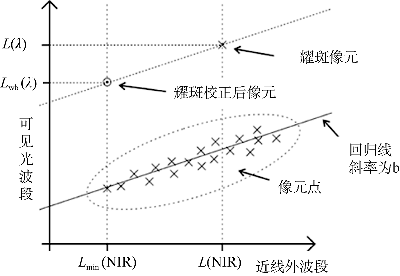
Fig. 5
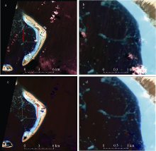
Fig. 6
Image and its corresponding magnification before and after sun glint correction (a, b: before correction; c, d: after correction)"

Fig. 6
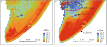
Fig. 7
Estimated water depth map from the log-ratio model (a) and dual-band linear model by using Gaofen-1 image"
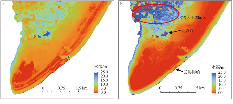
Fig. 7

Fig. 8
Scatter plots of retrieved water depths from the log-ratio model (a) and dual-band linear model (b) versus actual water depths"
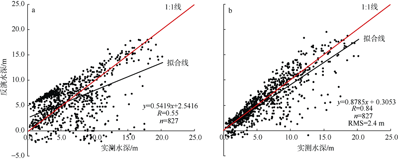
Fig. 8
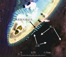
Fig. 9
Graphical display of the outlier points"
Fig. 9
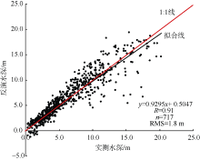
Fig. 10
Same as Fig. 8b, except after eliminating the outlier points"
Fig. 10
Tab. 4
Error estimation of different water depth ranges"
| 水深范围/m | 0~5 | 5~10 | 10~15 | 15~20 |
|---|---|---|---|---|
| 验证点数/个 | 349 | 233 | 113 | 22 |
| 均方根误差(RMS)/m | 1.14 | 1.89 | 2.67 | 3.33 |
Tab. 4
| 1 | 陈坚, 金翔龙, 2002. 机载激光测深技术进展及应用[J]. 海洋通报, 21(6): 75-82. |
| CHEN JIAN, JIN XIANGLONG, 2002. Advances in and application of airborne laser bathymetry technology[J]. Marine Science Bulletin, 21(6): 75-82 (in Chinese). | |
| 2 | 陈蕾, 邓孺孺, 何颖清, 等, 2012. 基于海岛阴坡植被和短波红外水体的遥感水色大气校正——以ETM影像为例[J]. 海洋学报, 34(5): 183-190. |
| CHEN LEI, DENG RURU, HE YINQING, et al, 2012. The ocean color atmospheric correction based on water body characteristics of SWIR and vegetation on the shadow side of oceanic island: A case study of ETM data[J]. Acta Oceanologica Sinica, 34(5): 183-190 (in Chinese). | |
| 3 | 陈启东, 邓孺孺, 陈蕾, 等, 2014. 西沙群岛岛礁区域WorldView-2影像大气校正[J]. 热带海洋学报, 33(3): 88-94. |
| CHEN QIDONG, DENG RURU, CHEN LEI, et al, 2014. Atmospheric correction of WorldView-2 data for the Xisha islands and reefs imagery[J]. Journal of Tropical Oceanography, 33(3): 88-94 (in Chinese). | |
| 4 | 党福星, 丁谦, 2003. 利用多波段卫星数据进行浅海水深反演方法研究[J]. 海洋通报, 22(3): 55-60. |
| DANG FUXING, DING QIAN, 2003. A technique for extracting water depth information from multispectral scanner data in the South China Sea[J]. Marine Science Bulletin, 22(3): 55-60 (in Chinese). | |
| 5 | 邸凯昌, 丁谦, 陈薇, 等, 1999. 南沙群岛海域浅海水深提取及影像海图制作技术[J]. 国土资源遥感, 41(3): 59-64. |
| DI KAICHANG, DING QIAN, CHEN WEI, et al, 1999. Shallow water depth extraction and chart production from TM images in Nansha islands and nearby sea area[J]. Remote Sensing for Land & Resources, 41(3): 59-64 (in Chinese). | |
| 6 | 郭红, 顾行发, 谢勇, 等, 2014. 基于ZY-3CCD相机数据的暗像元大气校正方法分析与评价[J]. 光谱学与光谱分析, 34(8): 2203-2207. |
| GUO HONG, GU XINGFA, XIE YONG, et al, 2014. Evaluation of four dark object atmospheric correction methods based on ZY-3CCD data[J]. Spectroscopy and Spectral Analysis, 34(8): 2203-2207 (in Chinese). | |
| 7 | 黄文骞, 吴迪, 杨杨, 等, 2013. 浅海多光谱遥感水深反演技术[J]. 海洋技术, 32(2): 43-46. |
| HUANG WENQIAN, WU DI, YANG YANG, et al, 2013. Multi-spectral remote sensing water depth retrieval technique in shallow sea[J]. Ocean Technology, 32(2): 43-46 (in Chinese). | |
| 8 | 梁建, 张杰, 马毅, 2015. 控制点与检查点数量和比例对水深遥感反演精度的影响分析[J]. 海洋科学, 39(2): 15-19. |
| LIANG JIAN, ZHANG JIE, MA YI, 2015. Analysis of the influence of the amount and proportion of control points and check points on the accuracy of bathymetry remote sensing inversion[J]. Marine Sciences, 39(2): 15-19 (in Chinese). | |
| 9 | 盛琳, 王双亭, 周高伟, 等, 2015. 非线性模型岛礁礁盘遥感水深反演[J]. 测绘科学, 40(10): 43-47. |
| SHENG LIN, WANG SHUANGTING, ZHOU GAOWEI, et al, 2015. Research on reefs bathymetry estimation by remote sensing based on nonlinear model[J]. Science of Surveying and Mapping, 40(10): 43-47 (in Chinese). | |
| 10 | 徐兵, 2013. 珊瑚礁遥感监测方法研究[D]. 南京: 南京师范大学: 1-107. |
| XU BING, 2013. Method study of coral reef remote sensing monitoring[D]. Nanjing: Nanjing Normal University: 1-107 (in Chinese). | |
| 11 | 许海蓬, 马毅, 梁建, 等, 2014. 基于半经验模型的水深反演及不同水深范围的误差分析[J]. 海岸工程, 33(1): 19-25. |
| XU HAIPENG, MA YI, LIANG JIAN, et al, 2014. Bathymetry inversion based on semi-empirical model and error analysis of different water depth ranges[J]. Coastal Engineering, 33(1): 19-25 (in Chinese). | |
| 12 | 张鹰, 张芸, 张东, 等, 2009. 南黄海辐射沙脊群海域的水深遥感[J]. 海洋学报, 31(3): 39-45. |
| ZHANG YING, ZHANG YUN, ZHANG DONG, et al, 2009. An underwater bathymetry reversion in the radial sand ridge group region of the southern Huanghai Sea using the remote sensing technology[J]. Acta Oceanologica Sinica, 31(3): 39-45 (in Chinese). | |
| 13 | EUGENIO F, MARCELLO J, MARTIN J, 2015. High-resolution maps of bathymetry and benthic habitats in shallow-water environments using multispectral remote sensing imagery[J]. IEEE Transactions on Geoscience and Remote Sensing, 53(7): 3539-3549. |
| 14 | GOODMAN J A, LEE Z, USTIN S L, 2008. Influence of atmospheric and sea-surface corrections on retrieval of bottom depth and reflectance using a semi-analytical model: a case study in Kaneohe Bay, Hawaii[J]. Applied Optics, 47(28): F1-F11. |
| 15 | HEDLEY P J, HARBORNE, A R, MUMBY P J, 2005. Simple and robust removal of sun glint for mapping shallow-water benthos[J]. International Journal of Remote Sensing, 26(10): 2107-2112. |
| 16 | HOCHBERG E J, ANDREFOUET S, TYLER M R, 2003. Sea surface correction of high spatial resolution Ikonos images to improve bottom mapping in near-shore environments[J]. IEEE Transactions on Geoscience and Remote Sensing, 41(7): 1724-1729. |
| 17 | JAY S, GUILLAUME M, 2014. A novel maximum likelihood based method for mapping depth and water quality from hyperspectral remote-sensing data[J]. Remote Sensing of Environment, 147: 121-132. |
| 18 | LYZENGA D R, 1978. Passive remote sensing techniques for mapping water depth and bottom features[J]. Applied Optics, 17(3): 379-383. |
| 19 | LYZENGA D R, 1981. Remote sensing of bottom reflectance and water attenuation parameters in shallow water using aircraft and Landsat data[J]. International Journal of Remote Sensing, 2(1): 71-82. |
| 20 | LYZENGA D R, 1985. Shallow-water bathymetry using combined lidar and passive multispectral scanner data[J]. International Journal of Remote Sensing, 6(1): 115-125. |
| 21 | LYZENGA D R, MALINAS N P, TANIS F J, 2006. Multispectral bathymetry using a simple physically based algorithm[J]. IEEE Transactions on Geoscience and Remote Sensing, 44(8): 2251-2259. |
| 22 | PHILPOT W D, 1987. Radiative transfer in stratified waters: a single-scattering approximation for irradiance[J]. Applied Optics, 26(19): 4123-4132. |
| 23 | PHILPOT W D, 1989. Bathymetric mapping with passive multispectral imagery[J]. Applied Optics, 28(8): 1569-1578. |
| 24 | SANDIDGE J C, HOLYER R J, 1998. Coastal bathymetry from hyperspectral observations of water radiance[J]. Remote Sensing of Environment, 65(3): 341-352. |
| 25 | STUMPF R P, HOLDERIED K, SINCLAIR M, 2003. Determination of water depth with high-resolution satellite imagery over variable bottom types[J]. Limnology and Oceanography, 48(1part2): 547-556. |
| 26 | SU HAIBIN, LIU HONGXING, WANG LEI, et al, 2014. Geographically adaptive inversion model for improving bathymetric retrieval from satellite multispectral imagery[J]. IEEE Transactions on Geoscience and Remote Sensing, 52(1): 465-476. |
| [1] | ZHAO Zhongwei, WU Lingyun, GAO Weijian, LI Wei. A study of the effect of shore platform morphology on coastal erosion of rocky cliffs in the Wucaiwan Bay, E’man, Hainan Island [J]. Journal of Tropical Oceanography, 2024, 43(5): 106-115. |
| [2] | WANG Jiaxi, LU Humu, QI Xin, GAO Chenghai, LIU Yonghong, LUO Xiaowei. Study on the secondary metabolites from the Weizhou Island coral Acropora austera associated fungus Arachniotus ruber GXIMD 02510 and their antibacterial activity [J]. Journal of Tropical Oceanography, 2024, 43(4): 174-180. |
| [3] | GAO Jie, YU Kefu, XU Shendong, HUANG Xueyong, CHEN Biao, WANG Yonggang. Content and source analysis of organic carbon in the outer slope sediments of the Yongle Atoll, Xisha Islands [J]. Journal of Tropical Oceanography, 2024, 43(3): 131-145. |
| [4] | ZHANG Yuyang, LIU Chengyue, YU Xiaolei, LUO Yong, ZHOU Tiancheng, LIAN Jiansheng, HUANG Hui. Study on relocation effect of scleractinian coral in the Fenghuang Island, Sanya* [J]. Journal of Tropical Oceanography, 2024, 43(3): 177-186. |
| [5] | LEI Mingfeng, YU Kefu, LIAO Zhiheng, CHEN Biao, HUANG Xueyong, CHEN Xiaoyan. The rapid ecological degradation and its impact on fish of the Yinyu Island in the Xisha Islands [J]. Journal of Tropical Oceanography, 2024, 43(3): 87-99. |
| [6] | LIANG Yuxian, LIU Chengyue, YU Xiaolei, ZHANG Yuyang, LIAN Wenke, CHEN Lunju, HUANG Hui. Focusing on supplementing and restoring degraded coral reefs with key groups of reef-building coral - paradigms in the restoration of Xidao Island’s coral reef [J]. Journal of Tropical Oceanography, 2024, 43(3): 166-176. |
| [7] | CHEN Shu, XU Hong, LU Shushen, Zhang Haiyang, MA Yazeng, LUO Jinxiong. The framework, reservoir characteristics and reef formation model of Miocene algal reef dolomite in the Xisha Islands* [J]. Journal of Tropical Oceanography, 2024, 43(2): 140-153. |
| [8] | CHEN Junqiang, WANG Wenbo, WANG Qing, YANG Yufeng. Species diversity and habitat preference of bdelloid rotifers in the Weizhou island, Guangxi [J]. Journal of Tropical Oceanography, 2024, 43(2): 81-91. |
| [9] | ZHAO Jinfa, LIU Yong, LI Chunhou, WANG Teng, SHI Juan, XIAO Yayuan, WU Peng, SONG Xiaoyu. Study on species composition and distribution of fish eggs in Yongle Atoll and Dongdao Island by high-throughput sequencing technology [J]. Journal of Tropical Oceanography, 2023, 42(6): 127-136. |
| [10] | ZENG Weite, ZHANG Dongqiang, LIU Bing, YANG Yongpeng, ZHANG Hangfei, WU Duoyu, WANG Xiaolin. Distribution, main controlling factors and pollution assessment of heavy metals in surface seawater of the Northern Bay of Hainan Island, south China [J]. Journal of Tropical Oceanography, 2023, 42(6): 156-167. |
| [11] | XING Nannan, REN Runxin, TANG Zhenzhou, LUO Zhihong, XIA Chenxi, LIU Yonghong, PENG Liang, CHEN Xianqiang. Study on the secondary metabolites of fungus Aspergillus sp. GXIMD02003 derived from marine sediment in the Weizhou island [J]. Journal of Tropical Oceanography, 2023, 42(5): 154-160. |
| [12] | GUO Jianlin, SUN Xian, YANG Yufeng, WANG Qing. The succession characteristics of copepod community structure in the seaweed bed and its adjacent waters in the Weizhou Island, Guangxi Province [J]. Journal of Tropical Oceanography, 2023, 42(4): 155-165. |
| [13] | HU Chenyue, QIU Zhongfeng, LIAO Kuo, ZHAO Dongzhi, WU Daomao. CALIOP remote sensing monitoring of the Fujian sea fog and spectral characteristics analysis of subcloud fog based on Himawari-8 [J]. Journal of Tropical Oceanography, 2023, 42(4): 104-112. |
| [14] | WANG Pengxia, ZHAO Yi, DU Xiaofei, WANG Weiquan, WANG Xiaoxue. Identification and functional study of the genomic island GIPspSM9913 in Pseudoalteromonas sp. SM9913 [J]. Journal of Tropical Oceanography, 2023, 42(2): 45-53. |
| [15] | YANG Hongqiang, TAN Fei, XU Huilong, ZHANG Xiyang, SHI Qi, TAO Shichen. Reconstruction of the tropical cyclones activity in the Nansha Islands since the Little Ice Age from the atoll lagoon sediments [J]. Journal of Tropical Oceanography, 2022, 41(6): 171-182. |
|
||