
Journal of Tropical Oceanography ›› 2022, Vol. 41 ›› Issue (2): 26-37.doi: 10.11978/2021045CSTR: 32234.14.2021045
• Marine Meteorology • Previous Articles Next Articles
Analysis of diurnal variation characteristics of precipitation over South China before typhoon landfall
LI Zhuo1( ), LI Weibiao1,2, ZHANG Aoqi1,2()
- 1. Sun Yat-sen University, Zhuhai 519080, China
2. Laboratory of Southern Ocean Science and Engineering (Zhuhai), Zhuhai 519080, China
-
Received:2021-04-09Revised:2021-07-07Online:2022-03-10Published:2021-07-09 -
Contact:ZHANG Aoqi E-mail:lizh227@mail2.sysu.edu.cn;zhangaoq3@mail.sysu.edu.cn -
Supported by:National Natural Science Foundation of China(42075004);National Natural Science Foundation of China(42005062);Natural Science Foundation of Guangdong Province of China(2021A1515011404)
CLC Number:
- P732.42
Cite this article
LI Zhuo, LI Weibiao, ZHANG Aoqi. Analysis of diurnal variation characteristics of precipitation over South China before typhoon landfall[J].Journal of Tropical Oceanography, 2022, 41(2): 26-37.
share this article
Add to citation manager EndNote|Reference Manager|ProCite|BibTeX|RefWorks
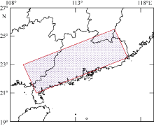
Fig. 1
The key area used in this study, shown by the red box"
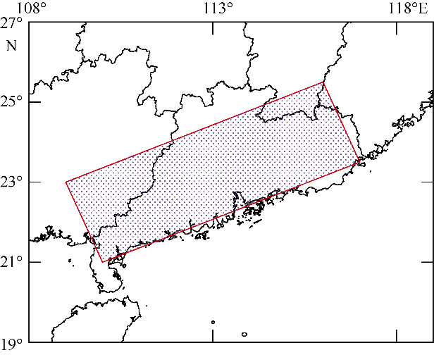
Fig. 1
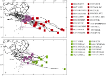
Fig. 2
The selected Typhoon-1 (a) and Typhoon-2 (b) from 1998 to 2017. Their numbers, names, routes, and longitude and latitude of typhoon center on day0 as shown in the picture. The points marked in the purple box are the longitudes and latitudes of the typhoons’ centers when the first wave of cyclonic spiral rain band reached South China"

Fig. 2
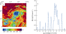
Fig. 3
Horizontal distribution of Himawari-8 10.4 μm brightness temperature on day0 moment for typhoon 201604 (a), and time series of average precipitation within the study area before and after day0 (b)"

Fig. 3
Tab. 1
Basic information for two classes of typhoons"
| 1类台风: 影响下华南地区午后降水强(20个) | 2类台风: 影响下华南地区午后降水不明显(12个) | ||||||||
|---|---|---|---|---|---|---|---|---|---|
| 编号 | 起始月份 | 最大强度 | day0强度 | day0日期/(月.日) | 编号 | 起始月份 | 最大强度 | day0强度 | day0日期/(月.日) |
| 199803 | 8 | 强热带风暴 | 热带风暴 | 8.9 | 199910 | 9 | 强热带风暴 | 热带风暴 | 9.12 |
| 200104 | 7 | 台风 | 台风 | 7.4 | 200308 | 7 | 强热带风暴 | 热带风暴 | 7.19 |
| 200107 | 7 | 台风 | 热带风暴 | 7.23 | 200313 | 8 | 强台风 | 台风 | 9.1 |
| 200307 | 7 | 强台风 | 强台风 | 7.22 | 200606 | 8 | 台风 | 热带风暴 | 8.1 |
| 200312 | 8 | 台风 | 台风 | 8.23 | 200616 | 9 | 超强台风 | 台风 | 9.29 |
| 200812 | 8 | 台风 | 台风 | 8.21 | 201117 | 9 | 强台风 | 台风 | 9.28 |
| 200814 | 9 | 强台风 | 强台风 | 9.22 | 201119 | 9 | 强台风 | 台风 | 9.30 |
| 200906 | 7 | 台风 | 强热带风暴 | 7.17 | 201319 | 9 | 超强台风 | 超强台风 | 9.20 |
| 200915 | 9 | 台风 | 热带风暴 | 9.13 | 201330 | 11 | 超强台风 | 台风 | 11.8 |
| 201108 | 7 | 强热带风暴 | 热带风暴 | 7.28 | 201522 | 10 | 强台风 | 热带风暴 | 10.2 |
| 201306 | 6 | 强热带风暴 | 热带风暴 | 6.30 | 201621 | 10 | 超强台风 | 台风 | 10.16 |
| 201311 | 8 | 超强台风 | 台风 | 8.12 | 201720 | 10 | 强台风 | 热带风暴 | 10.13 |
| 201321 | 10 | 超强台风 | 热带风暴 | 9.27 | |||||
| 201409 | 7 | 超强台风 | 台风 | 7.16 | |||||
| 201415 | 9 | 台风 | 台风 | 9.15 | |||||
| 201604 | 7 | 强台风 | 强热带风暴 | 7.31 | |||||
| 201622 | 10 | 超强台风 | 超强台风 | 10.19 | |||||
| 201707 | 7 | 热带风暴 | 热带风暴 | 7.22 | |||||
| 201713 | 8 | 强台风 | 热带风暴 | 8.20 | |||||
| 201714 | 8 | 台风 | 热带风暴 | 8.25 | |||||
Tab. 1
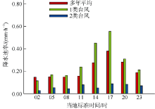
Fig. 4
Changes of precipitation rate in a day, which were three days before day0"

Fig. 4
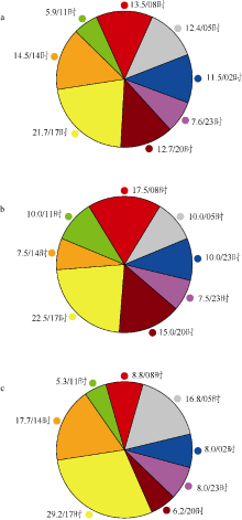
Fig. 5
Probability distribution of precipitation peak in key area under the influence of two kinds of typhoons and of annual average precipitation from June to November"

Fig. 5
Fig. 6
The average horizontal distributions of precipitation overlapped with 850 hPa wind field at different local times within three days before day0 under the influence of Typhoon-1 (a~d) and Typhoon-2 (c~d). The red box indicates the key area"
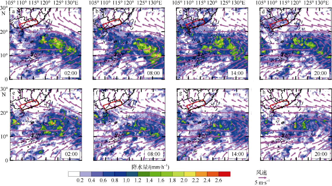
Fig. 6
Fig. 7
Temporal variations of vertical velocity (a, b), CAPEL (c, d), temperature (e, f), and specific humidity (g, h) with height in the key area within three days before day0"
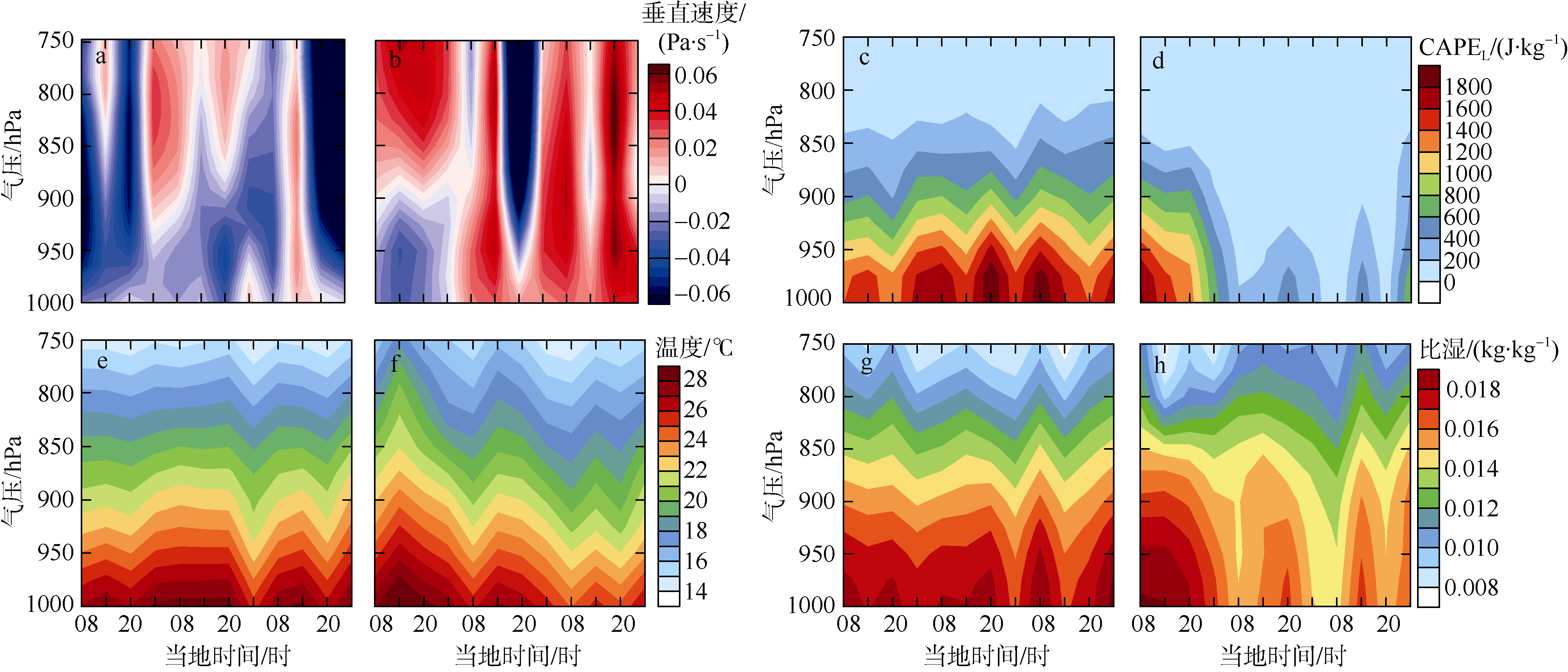
Fig. 7
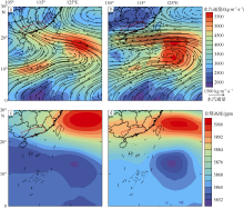
Fig. 8
Horizontal distributions of average 500 hPa geopotential height overlapped with column water vapor flux within three days before day0 for the two types of typhoon"

Fig. 8
| [1] | 陈炯, 郑永光, 张小玲, 等, 2013. 中国暖季短时强降水分布和日变化特征及其与中尺度对流系统日变化关系分析[J]. 气象学报, 71(3). 367-382. |
| CHEN JIONG, ZHENG YONGGUANG, ZHANG XIAOLING, et al, 2013. Analysis of the climatological distribution and diurnal variations of the short-duration heavy rain and its ralation with diurnal variations of the MCSs over China during the warm season[J]. Acta Meteorologica Sinica, 71(3): 367-382. (in Chinese with English abstract) | |
| [2] | 黄天福, 谢佳君, 刘鹏, 2013. 基于多卫星资料的全国夏秋季节降水日变化特征研究[J]. 贵州气象, 37(6): 30-33. (in Chinese) |
| [3] | 李传祥, 王咏青, 夏华弟, 等, 2013. “海棠”、“罗莎”和“莫拉克”登陆前降水量差异分析[J]. 浙江气象, 34(2): 32-39. (in Chinese) |
| [4] | 李德帅, 2013. 基于逐小时资料的华南地区汛期降水时空变化特征及其成因研究[D]. 兰州: 兰州大学: 1-151. |
| LI DESHUAI, 2013. Research on the spatiotemporal characteristics of hourly precipitation over South China during the warm season and its possible causes[D]. Lanzhou: Lanzhou University: 1-151. (in Chinese with English abstract) | |
| [5] | 吕翔, 徐海明, 2007. 中南半岛地区夏季降水日变化特征[J]. 南京气象学院学报, 30(5): 632-642. |
| LÜ XIANG, XU HAIMING, 2007. Diurnal variations of rainfall in summer over the Indo-China peninsula[J]. Journal of Nanjing Institute of Meteorology, 30(5): 632-642. (in Chinese with English abstract) | |
| [6] | 莫志祥, 1983. 从两次暴雨过程看热力条件分析的重要性[J]. 广西气象, (3): 21-24. (in Chinese) |
| [7] | 唐红玉, 顾建峰, 俞胜宾, 等, 2011. 西南地区降水日变化特征分析[J]. 高原气象, 30(2): 376-384. |
| TANG HONGYU, GU JIANFENG, YU SHENGBIN, et al, 2011. Analysis on diurnal variation of precipitation in Southwest China[J]. Plateau Meteorology, 30(2): 376-384. (in Chinese with English abstract) | |
| [8] | 唐晓春, 刘会平, 潘安定, 等, 2003. 广东沿海地区近50年登陆台风灾害特征分析[J]. 地理科学, 23(2): 182-187. |
| TANG XIAOCHUN, LIU HUIPING, PAN ANDING, et al, 2003. Analysis of disastrous features of landing Typhoo in coastal regions of Guangdong province in recent 50 years[J]. Scientia Geographica Sinica, 23(2): 182-187. (in Chinese with English abstract) | |
| [9] | 王美蓉, 郭栋, 钟珊珊, 2019. 多源资料在青藏高原大气热源计算中的适用性分析[J]. 气象, 45(12): 1718-1726. |
| WANG MEIRONG, GUO DONG, ZHONG SHANSHAN, 2019. Comparision of the multi-source datasets in calculation of the atmospheric heat sources over the Tibetan Plateau[J]. Meteorological Monthly, 45(12): 1718-1726. (in Chinese with English abstract) | |
| [10] | 王文秀, 郭汝凤, 陈世发, 等, 2018. 1951-2016年登陆我国华南地区台风的时空分布特征分析[J]. 防护林科技, (6): 16-18. |
| WANG WENXIU, GUO RUFENG, CHEN SHIFA, et al, 2018. Spatial and temporal distribution characteristics of Typhoons in Southern China from 1951 to 2016[J]. Protection Forest Science and Technology, (6): 16-18. (in Chinese with English abstract) | |
| [11] | 夏静雯, 傅云飞, 2016. 东亚与南亚雨季对流和层云降水云内的温湿结构特征分析[J]. 大气科学, 40(3): 563-580. |
| XIA JINGWEN, FU YUNFEI, 2016. The vertical characteristics of temperature and humidity inside convective and stratiform precipitating clouds in the East Asian summer monsoon region and Indian summer monsoon region[J]. Chinese Journal of Atmospheric Sciences, 40(3): 563-580. (in Chinese with English abstract) | |
| [12] | 许春林, 王文波, 杨森槐, 等, 2009. 台风“鹦鹉”登陆过程中肇庆降水显著偏弱的原因[J]. 广东气象, 31(6): 32-35. |
| XU CHUNLIN, WANG WENBO, YANG SENHUAI, et al, 2009. Significantly weaker precipitation in Zhaoqing during the landfall of typhoon Nuri compared to historical cases[J]. Guangdong Meteorology, 31(6): 32-35. (in Chinese with English abstract) | |
| [13] | 徐建平, 林佩云, 1995. 台湾地形对过岛台风的影响[J]. 广东气象, (4): 42-44. |
| XU JIANPING, LIN PEIYUN, 1995. The influence of Taiwan topography on Typhoon crossing the island[J]. Guangdong Meteorology, (4): 42-44. (in Chinese with English abstract) | |
| [14] | 杨慧, 2019. 1960-2017年中国热带气旋降水气候特征研究[D]. 北京: 中国气象科学研究院: 1-62. |
| YANG HUI, 2019. Research on the climate characteristics of Tropical cyclone precipitation in China from 1960 to 2017[D]. Beijing: Chinese Academy of Meteorological Sciences: 1-62. (in Chinese with English abstract) | |
| [15] | 杨云月, 许涛, 罗翠榆, 等, 2020. 典型厄尔尼诺期间台风降水δ18O变化分析: 以2018年22号台风“山竹”为例[J]. 热带海洋学报, 39(4): 34-41. |
| YANG YUNYUE, XU TAO, LUO CUIYU, et al, 2020. Analysis on the variation of typhoon precipitation δ18O during typical El Niño event: A case study of Typhoon Mangkhut (2018)[J]. Journal of Tropical Oceanography, 39(4): 34-41. (in Chinese with English abstract) | |
| [16] | 宇如聪, 李建, 陈昊明, 等, 2014. 中国大陆降水日变化研究进展[J]. 气象学报, 72(5): 948-968. |
| YU RUCONG, LI JIAN, CHEN HAOMING, et al, 2014. Progress in studies of the precipitation diurnal variation over contiguous China[J]. Acta Meteorologica Sinica, 72(5): 948-968. (in Chinese with English abstract) | |
| [17] | 宇如聪, 李建, 2016. 中国大陆日降水峰值时间位相的区域特征分析[J]. 气象学报, 74(1): 18-30. |
| YU RUCONG, LI JIAN, 2016. Regional characteristics of diurnal peak phases of precipitation over contiguous China[J]. Acta Meteorologica Sinica, 74(1): 18-30. (in Chinese with English abstract) | |
| [18] | 张长江, 薛利成, 马雷鸣, 等, 2018. 热带气旋客观定位的红外亮温方差方法[J]. 中国图象图形学报, 23(3): 450-457. |
| ZHANG CHANGJIANG, XUE LICHENG, MA LEIMING, et al, 2018. Infrared brightness-temperature variance method for the objective location of tropical cyclones[J]. Journal of Image and Graphics, 23(3): 450-457. (in Chinese with English abstract) | |
| [19] | 张思齐, 2019. 全球再分析与中国观测资料对比研究[D]. 北京: 中国气象科学研究: 1-72. |
| ZHANG SIQI, 2019. Comparison research of observation and reanalysis data over China[D]. Beijing: Chinese Academy of Meteorological Sciences: 1-72.(in Chinese with English abstract) | |
| [20] | 张学敏, 1991. 台风环流降水的诊断分析[J]. 海洋预报, 8(1): 76-83. |
| ZHANG XUEMIN,, 1991. Diagnostic analysis of typhoon circulation precipitation[J]. Marine Forecasts, 8(1): 76-83 (in Chinese with English abstract). | |
| [21] | 周琴芳, 2019. 副热带高压对“灿鸿”和“苏迪罗”台风路径的影响[J]. 现代农业科技, (19): 196-197, 200. |
| ZHOU QINFANG, 2019. Influence of subtropical high on Typhoon track of “Canhong” and “Sudiro”[J]. Modern Agricultural Science and Technology, (19): 196-197, 200. (in Chinese with English abstract) | |
| [22] | 邹丽丽, 谭桂容, 李任承, 等, 2017. 对流有效位能的本质和一种新的计算方法[J]. 气象科技进展, 7(3): 6-15. |
| ZOU LILI, TAN GUIRONG, LI RENCHENG, et al, 2017. On the essence and new computing method of convective available potential energy[J]. Advances in Meteorological Science and Technology, 7(3): 6-15. (in Chinese with English abstract) | |
| [23] | BESSHO K, DATE K, HAYASHI M, et al, 2016. An introduction to Himawari-8/9 - Japan’s new-generation geostationary meteorological satellites[J]. Journal of the Meteorological Society of Japan. Ser. Ⅱ, 94(2): 151-183. |
| [24] |
CHANG A T C, CHIU L S, KUMMEROW C, et al, 1999. First results of the TRMM Microwave Imager (TMI) monthly oceanic rain rate: comparison with SSM/I[J]. Geophysical Research Letters, 26(15): 2379-2382.
doi: 10.1029/1998GL900452 |
| [25] |
HU HAO, DUAN YIHONG, WANG YUQING, et al, 2017. Diurnal cycle of rainfall associated with Landfalling tropical cyclones in China from rain gauge observations[J]. Journal of Applied Meteorology and Climatology, 56(9): 2595-2605.
doi: 10.1175/JAMC-D-16-0335.1 |
| [26] |
NESBITT S W, ZIPSER E J, 2003. The diurnal cycle of rainfall and convective intensity according to three years of TRMM measurements[J]. Journal of Climate, 16(10): 1456-1475.
doi: 10.1175/1520-0442(2003)016<1456:TDCORA>2.0.CO;2 |
| [27] | SHEN YAN, XIONG ANYUAN, WANG YING, et al, 2010. Performance of high-resolution satellite precipitation products over China[J]. Journal of Geophysical Research: Atmospheres, 115(D2): D02114. |
| [28] |
YAO SUXIANG, HUANG QIAN, 2016. An analysis of extreme intraseasonal rainfall events during January-March 2010 over eastern China[J]. Dynamics of Atmospheres and Oceans, 75: 22-32.
doi: 10.1016/j.dynatmoce.2016.04.001 |
| [29] | YU RUCONG, ZHOU TIANJUN, XIONG ANYUAN, et al, 2007. Diurnal variations of summer precipitation over contiguous China[J]. Geophysical Research Letters, 34(1): L01704. |
| [30] |
YUAN WEIHUA, YU RUCONG, ZHANG MINGHUA, et al, 2012. Regimes of diurnal variation of summer rainfall over subtropical East Asia[J]. Journal of Climate, 25(9): 3307-3320.
doi: 10.1175/JCLI-D-11-00288.1 |
| [31] | ZHANG AOQI, CHEN YILUN, ZHOU S N, et al, 2020. Diurnal variation of Meiyu rainfall in the Yangtze plain during atypical Meiyu Years[J]. Journal of Geophysical Research: Atmospheres, 125(1): e2019JD031742. |
| [32] |
ZHANG AOQI, FU YUNFEI, 2018. Life cycle effects on the vertical structure of precipitation in East China measured by Himawari-8 and GPM DPR[J]. Monthly Weather Review, 146(7): 2183-2199.
doi: 10.1175/MWR-D-18-0085.1 |
| [1] | XU Chao, LONG Lijuan, LI Sha, YUAN Li, XU Xiaolu. Systematic reorganization of historical data of scientific investigation in the South China Sea and its affiliated islands and reefs 3. data sharing service and application [J]. Journal of Tropical Oceanography, 2024, 43(5): 158-165. |
| [2] | XU Chao, LONG Lijuan, LI Sha, HE Yunkai, YUAN Li, XU Xiaolu. Systematic reorganization of historical data of scientific investigation in the South China Sea and its affiliated islands and reefs 1. data reorganization technology and application [J]. Journal of Tropical Oceanography, 2024, 43(5): 143-149. |
| [3] | XU Chao, LONG Lijuan, LI Sha, XU Xiaolu, YUAN Li. Systematic reorganization of historical data of scientific investigation in the South China Sea and its affiliated islands and reefs 2. data curation and application [J]. Journal of Tropical Oceanography, 2024, 43(5): 150-157. |
| [4] | SUN Zeming, HAN Shuzong, WANG Mingjie, SU Hanxiang. Statistical study on the influence of typhoon with different path on the temperature of coastal waters of China [J]. Journal of Tropical Oceanography, 2024, 43(5): 17-31. |
| [5] | SHANG Jie, WU Ying, ZOU Yike, MA Jingwen. Retrieval of typhoon precipitation rate over ocean surface based on FY-3D/MWRI Data* [J]. Journal of Tropical Oceanography, 2024, 43(5): 32-40. |
| [6] | LIU Yuan, KE Zhixin, LI Kaizhi, TAN Yehui, LIANG Junce, ZHOU Weihua. Zooplankton community in the coastal waters of eastern Guangdong under the influence of human activities and ocean currents [J]. Journal of Tropical Oceanography, 2024, 43(4): 98-111. |
| [7] | LIU Didi, ZHANG Xiyang, SUN Fulin, WANG Mingzhuang, TAN Fei, SHI Qi, WANG Guan, YANG Hongqiang. Microbial communities and specific strains within beachrocks of the South China Sea: implications for the origin of beachrock* [J]. Journal of Tropical Oceanography, 2024, 43(4): 112-122. |
| [8] | JIANG Lyumiao, CHEN Tianran, ZHAO Kuan, ZHANG Ting, XU Lijia. Experimental study on bioerosion of marginal reefs in the Weizhou Island, northern South China Sea [J]. Journal of Tropical Oceanography, 2024, 43(3): 155-165. |
| [9] | XU Lijia, LIAO Zhiheng, CHEN Hui, WANG Yongzhi, HUANG Baiqiang, LIN Qiaoyun, GAN Jianfeng, YANG Jing. Community structure of scleractinian corals in the northern South China Sea and their responses to the marine heatwaves [J]. Journal of Tropical Oceanography, 2024, 43(3): 58-71. |
| [10] | ZHAO Minghui, YUAN Ye, ZHANG Jiazheng, ZHANG Cuimei, GAO Jinwei, WANG Qiang, SUN Zhen, CHENG Jinhui. New developments on the rift-breakup of the continent-ocean transition zone in the northern margin of the South China Sea [J]. Journal of Tropical Oceanography, 2024, 43(2): 173-183. |
| [11] | HUANG Yu, WANG Lin, MAI Zhimao, LI Jie, ZHANG Si. Isolation and characterization of sand fixation ability of bacteria in biological soil crusts of the tropical islands, South China Sea [J]. Journal of Tropical Oceanography, 2023, 42(6): 101-110. |
| [12] | ZHANG Zheran, HU Junyang, ZHOU Kai, ZHANG Penghui, XING Jiuxing, CHEN Shengli. Storm surge simulations of the coastal area of Shenzhen using different types of typhoon meteorological fields—a case study of Typhoon Mangkhut* [J]. Journal of Tropical Oceanography, 2023, 42(6): 1-14. |
| [13] | WANG Chenyan, SHI Jingwen, YAN Annan, KANG Yaru, WANG Yuxuan, QIN Suli, HAN Minwei, ZHANG Ruijie, YU Kefu. Bioaccumulation characteristics and source apportionment of organophosphate esters in Acanthaster planci from the South China Sea [J]. Journal of Tropical Oceanography, 2023, 42(5): 30-37. |
| [14] | LI Niu, DI Pengfei, FENG Dong, CHEN Duofu. The impact of cold seepage on geochemical indices for redox conditions of marine sediments ―Site F active seep site in the northeastern South China Sea* [J]. Journal of Tropical Oceanography, 2023, 42(5): 144-153. |
| [15] | LI Junmin, LI Bo, CHEN Wuyang, LIU Junliang. Observation characteristics of coastal waves in Sanya and their responses to typhoon processes [J]. Journal of Tropical Oceanography, 2023, 42(4): 25-35. |
|
||