
Journal of Tropical Oceanography ›› 2020, Vol. 39 ›› Issue (2): 107-117.doi: 10.11978/2019063CSTR: 32234.14.2019063
• Marine Survey and Monitoring • Previous Articles Next Articles
Integrating spaceborne optical and SAR imagery for monitoring mangroves and Spartina alterniflora in Zhangjiang Estuary
Di DONG( ), Jisheng ZENG, Zheng WEI, Jinhui YAN
- South China Sea Institute of Planning and Environmental Research, South China Sea Bureau of Ministry of Natural Resources, Guangzhou 510300, China
-
Received:2019-07-09Revised:2019-10-12Online:2020-03-10Published:2020-03-10 -
Supported by:Open Fund of Key Laboratory of National Bureau of Surveying, Mapping and Geographic Information of China(2017NGCM08);Natural Science Foundation of Guangdong Province of China(2018A030310032);Guangdong Key Lab of Ocean Remote Sensing(South China Sea Institute of Oceanology Chinese Academy of Sciences)(2017B030301005-LORS1806)
CLC Number:
- P735.52
Cite this article
Di DONG, Jisheng ZENG, Zheng WEI, Jinhui YAN. Integrating spaceborne optical and SAR imagery for monitoring mangroves and Spartina alterniflora in Zhangjiang Estuary[J].Journal of Tropical Oceanography, 2020, 39(2): 107-117.
share this article
Add to citation manager EndNote|Reference Manager|ProCite|BibTeX|RefWorks
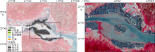
Fig. 1
Location of the study area, spatial distribution of the sample data (a) and the Sentinel-2A image of the study area on October 1st, 2018 (b). The black rectangle in (a) denotes the study area; the band combination of the Sentinel-2 A image is near-infrared band, red band and green band"
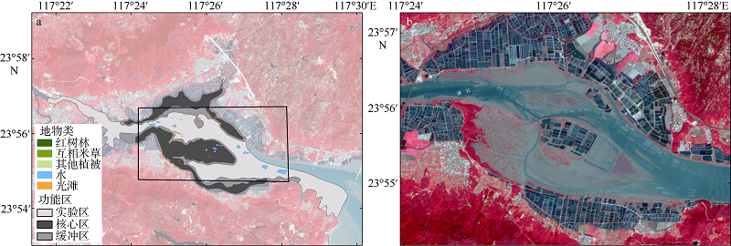
Fig. 1
Tab. 1
The sample information of different land covers in this study"
| 类别 | 红树林 | 互花米草 | 水 | 光滩 | 其他植被 |
|---|---|---|---|---|---|
| 2016年与2017年 | 40 (10.13) | 38 (2.04) | 12 (21.25) | 22 (5.58) | 17 (0.47) |
| 2018年 | 40 (10.13) | 55 (2.70) | 12 (21.25) | 22 (5.58) | 22 (0.66) |
Tab. 1
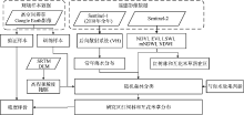
Fig. 2
Workflow of this study"
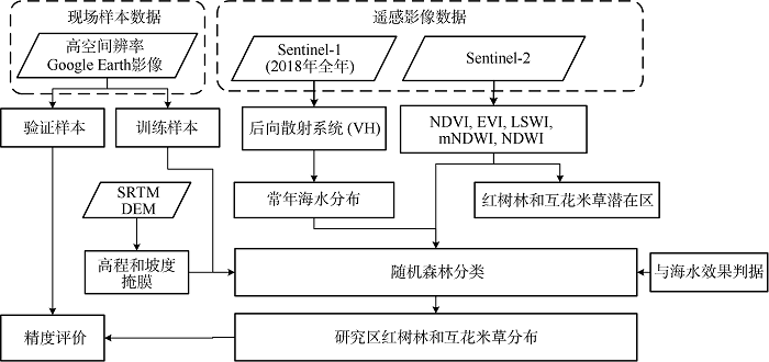
Fig. 2

Fig. 3
The potential distribution masks of Spartina alterniflora and mangroves (a), the classified map using random forest (b), and the yearlong seawater mask in the study region (c) in 2018"
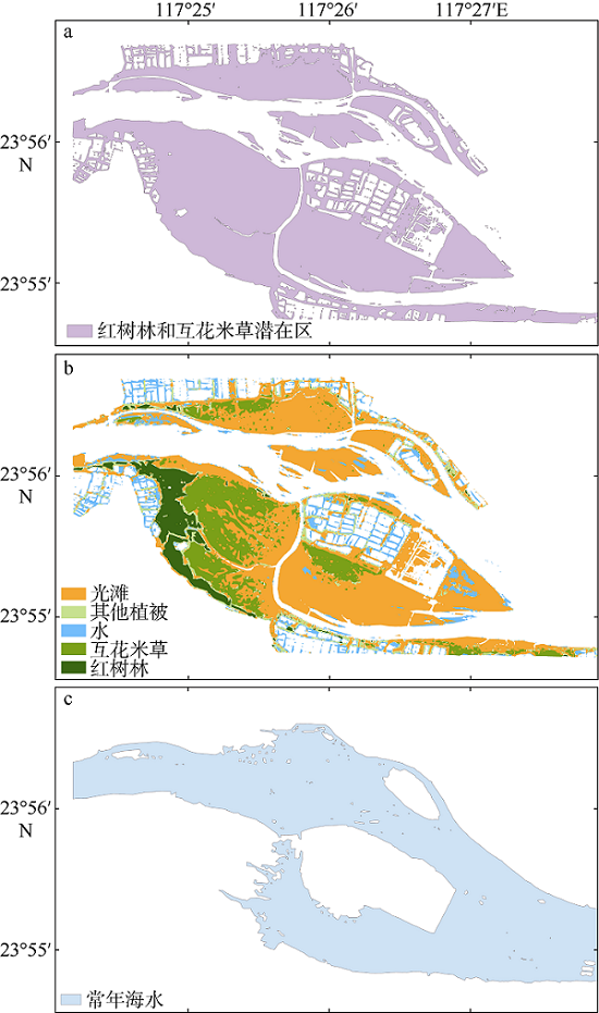
Fig. 3
Tab. 2
Confusion matrix and accuracy assessment for the study region from 2016 to 2018"
| 年度 | 类别 | 红树林 | 互花米草 | 光滩 | 水 | 其他植被 | 制图精度/% | 用户精度/% |
|---|---|---|---|---|---|---|---|---|
| 2016年 | 红树林 | 418 | 0 | 0 | 0 | 0 | 100.00 | 100.00 |
| 互花米草 | 0 | 99 | 3 | 0 | 0 | 97.06 | 100.00 | |
| 光滩 | 0 | 0 | 422 | 2 | 8 | 97.69 | 98.60 | |
| 水 | 0 | 0 | 0 | 318 | 1 | 99.69 | 98.76 | |
| 其他植被 | 0 | 0 | 3 | 2 | 17 | 77.27 | 65.39 | |
| 2017年 | 红树林 | 418 | 0 | 0 | 0 | 0 | 99.76 | 99.76 |
| 互花米草 | 0 | 90 | 1 | 9 | 2 | 94.74 | 94.74 | |
| 光滩 | 0 | 0 | 402 | 19 | 6 | 99.26 | 99.26 | |
| 水 | 0 | 5 | 0 | 319 | 0 | 91.93 | 91.93 | |
| 其他植被 | 1 | 0 | 2 | 0 | 19 | 70.37 | 70.37 | |
| 2018年 | 红树林 | 486 | 0 | 0 | 0 | 1 | 99.80 | 100.00 |
| 互花米草 | 0 | 76 | 5 | 0 | 0 | 93.83 | 98.70 | |
| 光滩 | 0 | 0 | 18 | 0 | 0 | 100.00 | 60.00 | |
| 水 | 0 | 0 | 0 | 628 | 2 | 99.68 | 100.00 | |
| 其他植被 | 0 | 1 | 7 | 0 | 18 | 69.23 | 85.71 |
Tab. 2
Tab. 3
Summary of land cover classification accuracies in the study region from 2016 to 2018"
| 2016年 | 2017年 | 2018年 | |
|---|---|---|---|
| 总体精度/% | 98.53 | 96.52 | 98.71 |
| Kappa系数 | 0.980 | 0.952 | 0.978 |
Tab. 3
"


Fig. 4
The Sentinel-2 satellite image (a) and distribution map of Spartina alterniflora and mangroves (b) on January 25th, 2016. The Sentinel-2 satellite image (c) and distribution map of Spartina alterniflora and mangroves (d) on February 11th, 2017. The Sentinel-2 satellite image (e) and distribution map of Spartina alterniflora and mangroves (f) on October 1st, 2018. The band combination of the Sentinel-2 A images on the left is blue band, green band and red band; and that on the right is near-infrared band, red band and green band"
Fig. 4
Tab. 4
The areas of mangroves and Spartina alterniflora in Zhangjiang Estuary (units: hm2)"
| 类别 | 2014年 | 2015年 | 2016年 | 2017年 | 2018年 |
|---|---|---|---|---|---|
| 红树林 | 59.91 ( | 62.19 ( | 60 ( 56.85 (本算法) | 59.88 (本算法) | 58.61 (本算法) |
| 互花米草 | — | 116.11 ( | 117 ( | 124.00 (本算法) | 142.39 (本算法) |
Tab. 4
Fig. 5
The Sentinel-2 satellite image (a) and distribution map of Spartina alterniflora and mangroves (b) on January 25th, 2016. The Sentinel-2 satellite image (c) and distribution map of Spartina alterniflora and mangroves (d) on February 11th, 2017. The Sentinel-2 satellite image (e) and distribution map of Spartina alterniflora and mangroves (f) on October 1st, 2018. All are in the southwest part of the study region. The band combination of the Sentinel-2 A images is near-infrared band, red band and green band"
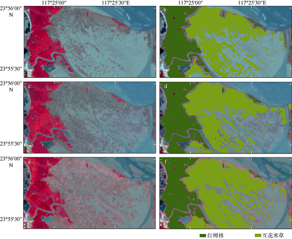
Fig. 5
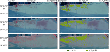
Fig. 6
The Sentinel-2 satellite image (a) and distribution map of Spartina alterniflora and mangroves (b) on January 25th, 2016. The Sentinel-2 satellite image (c) and distribution map of Spartina alterniflora and mangroves (d) on February 11th, 2017. The Sentinel-2 satellite image (e) and distribution map of Spartina alterniflora and mangroves (f) on October 1st, 2018. All are in the north part of the study region. The band combination of the Sentinel-2 A images is near-infrared band, red band and green band"
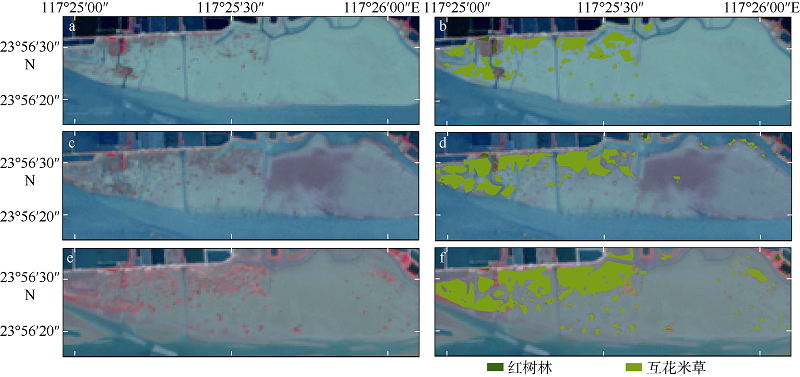
Fig. 6
| 1 | 陈权, 马克明 , 2015. 红树林生物入侵研究概况与趋势[J]. 植物生态学报, 39(3):283-299. |
| CHEN QUAN, MA KEMING, 2015. Research overview and trend on biological invasion in mangrove forests[J]. Chinese Journal of Plant Ecology, 39(3):283-299 (in Chinese with English abstract). | |
| 2 | 陈远丽, 路春燕, 刘金福 , 等, 2019. 漳江口湿地变化的遥感监测[J]. 森林与环境学报, 39(1):61-69. |
| CHEN YUANLI, LU CHUNYAN, LIU JINFU, et al, 2019. Remote sensing monitoring of Zhangjiang Estuary wetland[J]. Journal of Forest and Environment, 39(1):61-69 (in Chinese with English abstract). | |
| 3 | 和晓风, 林辉, 孙华 , 等, 2015. 基于GF-1卫星东洞庭湖湿地类型信息提取[J]. 中南林业科技大学学报, 35(11):10-15. |
| HE XIAOFENG, LIN HUI, SUN HUA, et al, 2015. Wetland types information extraction form east Dongting lake based on GF-1 satellite[J]. Journal of Central South University of Forestry & Technology, 35(11):10-15 (in Chinese with English abstract). | |
| 4 | 黄冠闽, 张宜辉, 方柏州 , 等, 2013. 互花米草对红树植物秋茄幼苗更新的影响[J]. 福建林业科技, 40(4):93-95, 113. |
| HUANG GUANMIN, ZHANG YIHUI, FANG BAIZHOU, et al, 2013. Effects of Spartina alterniflora on mangrove Kandelia candel seedlings regeneration[J]. Journal of Fujian Forestry Science and Technology, 40(4):93-95, 113 (in Chinese with English abstract). | |
| 5 | 黄华梅, 张利权 , 2007. 上海九段沙互花米草种群动态遥感研究[J]. 植物生态学报, 31(1):75-82. |
| HUANG HUAMEI, ZHANG LIQUAN, 2007. Remote Sensing analysis of range expansion of Spartina alterniflora at Jiuduansha shoals in Shanghai, China[J]. Chinese Journal of Plant Ecology, 31(1):75-82 (in Chinese with English abstract). | |
| 6 | 李春干, 谭必增 , 2003. 基于“3S”的红树林资源调查方法研究[J]. 自然资源学报, 18(2):215-221. |
| LI CHUNGAN, TAN BIZENG, 2003. Studies on the methods of mangrove inventory based on RS, GPS and GIS[J]. Journal of Natural Resources, 18(2):215-221 (in Chinese with English abstract). | |
| 7 | 李屹, 陈一宁, 李炎 , 2017. 红树林与互花米草盐沼交界区空间格局变化规律的遥感分析[J]. 海洋通报, 36(3):348-360. |
| LI YI, CHEN YINING, LI YAN, 2017. Remote sensing analysis of the changes in the ecotone of mangrove forests and Spartina alterniflora saltmarshes[J]. Marine Science Bulletin, 36(3):348-360 (in Chinese with English abstract). | |
| 8 | 刘春悦, 张树清, 江红星 , 等, 2009. 江苏盐城滨海湿地外来种互花米草的时空动态及景观格局[J]. 应用生态学报, 20(4):901-908. |
| LIU CHUNYUE, ZHANG SHUQING, JIANG HONGXING, et al, 2009. Spatiotemporal dynamics and landscape pattern of alien species Spartina alterniflora in Yancheng coastal wetlands of Jiangsu Province, China[J]. Chinese Journal of Applied Ecology, 20(4):901-908 (in Chinese with English abstract). | |
| 9 | 潘卫华, 陈家金, 张春桂 , 等, 2011. 福建沿海水域互花米草蔓延的动态监测分析[J]. 中国农业气象, 32(S1):174-177. |
| PAN WEIHUA, CHEN JIAJIN, ZHANG CHUNGUI, et al, 2011. Dynamic monitoring analysis of expansion of Spartina alterniflora in Fujian[J]. Chinese Journal of Agrometeorology, 32(S1):174-177 (in Chinese with English abstract). | |
| 10 | 孙飒梅 , 2005. 三都湾互花米草的遥感监测[J]. 台湾海峡 227, 265. |
| SUN SAMEI, 2005. Monitoring of smooth cordgrass invasion by remote sensing in Sandu Bay, Fujian[J]. Journal of Oceanography in Taiwan Strait, 227, 265 (in Chinese with English abstract). | |
| 11 | 王友绍 , 2013. 红树林生态系统评价与修复技术[M]. 北京: 科学出版社. |
| WANG YOUSHAO, 2013. Assessment and remediation techniques of mangrove ecosystems[M]. Beijing: Science Press (in Chinese). | |
| 12 | 薛星宇, 刘红玉 , 2012. 基于ALOS影像的盐城海滨湿地遥感信息分类方法研究[J]. 遥感技术与应用, 27(2):248-255. |
| XUE XINGYU, LIU HONGYU, 2012. Study on the classification approaches of Yancheng coastal wetlands based on ALOS image[J]. Remote Sensing Technology and Application, 27(2):248-255 (in Chinese with English abstract). | |
| 13 | 袁爽, 况润元, 廖启卿 , 2018. 湿地植被遥感提取及动态变化研究——以崇明东滩为例[J]. 江西理工大学学报, 39(1):44-51. |
| YUAN SHUANG, KUANG RUNYUAN, LIAO QIQING, 2018. Remote sensing extraction and dynamic change of wetland vegetation—A case study of Eastern Chongming Island[J]. Journal of Jiangxi University of Science and Technology, 39(1):44-51 (in Chinese with English abstract). | |
| 14 | 张宜辉, 黄冠闽, 方清 , 等, 2011. 红树林和互花米草相互作用对环境变化的响应[C]//中国第五届红树林学术会议论文摘要集. 温州: 15 (in Chinese). |
| 15 | 周振超, 李贺, 黄翀 , 等, 2018. 红树林遥感动态监测研究进展[J]. 地球信息科学学报, 20(11):1631-1643. |
| ZHOU ZHENCHAO, LI HE, HUANG CHONG, et al, 2018. Review on dynamic monitoring of mangrove forestry using remote sensing[J]. Journal of Geo-Information Science, 20(11):1631-1643 (in Chinese with English abstract). | |
| 16 | BREIMAN L , 2001. Random forests[J]. Machine Learning, 45(1):5-32. |
| 17 | CHEN BANGQIAN, XIAO XIANGMING, LI XIANGPING , et al, 2017. A mangrove forest map of China in 2015: Analysis of time series Landsat 7/8 and Sentinel-1A imagery in Google Earth Engine cloud computing platform[J]. ISPRS Journal of Photogrammetry and Remote Sensing, 131:104-120. |
| 18 | GIRI C , 2016. Observation and monitoring of mangrove forests using remote sensing: Opportunities and challenges[J]. Remote Sensing, 8(9):783. |
| 19 | HUETE A R, LIU H Q, BATCHILY K , et al, 1997. A comparison of vegetation indices over a global set of TM images for EOS-MODIS[J]. Remote Sensing of Environment, 59(3):440-451. |
| 20 | KUENZER C, BLUEMEL A, GEBHARDT S , et al, 2011. Remote sensing of mangrove ecosystems: A review[J]. Remote Sensing, 3(5):878-928. |
| 21 | LIU KAI, LI XIA, SHI XUN , et al, 2008. Monitoring mangrove forest changes using remote sensing and GIS data with decision-tree learning[J]. Wetlands, 28(2):336-346. |
| 22 | LIU MINGYUE, LI HUIYING, LI LIN , et al, 2017. Monitoring the invasion of Spartina alterniflora using multi-source high-resolution imagery in the Zhangjiang Estuary, China[J]. Remote Sensing, 9(6):539. |
| 23 | LIU MINGYUE, Mao DEHUA, WANG ZONGMING , et al, 2018. Rapid invasion of Spartina alterniflora in the coastal zone of mainland China: New observations from landsat OLI images[J]. Remote Sensing, 10(12):1933. |
| 24 | MAHDIANPARI M, SALEHI B, MOHAMMADIMANESH F , et al, 2019. The first wetland inventory map of newfoundland at a spatial resolution of 10 m using Sentinel-1 and Sentinel-2 data on the Google earth engine cloud computing platform[J]. Remote Sensing, 11(1):43. |
| 25 | MAO DEHUA, LIU MINGYUE, WANG ZONGMING , et al, 2019. Rapid invasion of Spartina alterniflora in the coastal zone of mainland China: Spatiotemporal patterns and human prevention[J]. Sensors, 19(10):2308. |
| 26 | TUCKER C J , 1979. Red and photographic infrared linear combinations for monitoring vegetation[J]. Remote Sensing of Environment, 8(2):127-150. |
| 27 | WANG ANQI, CHEN JIADAI, JING CHANGWEI , et al, 2015. Monitoring the invasion of Spartina alterniflora from 1993 to 2014 with Landsat TM and SPOT 6 satellite data in Yueqing Bay, China[J]. PLoS One, 10(8):e0135538. |
| 28 | WANG CONG, LIU HONGYU, ZHANG YING , et al, 2014. Classification of land-cover types in muddy tidal flat wetlands using remote sensing data[J]. Journal of Applied Remote Sensing, 7(1):073457. |
| 29 | WANG LE, JIA MINGMING, YIN DAMENG , et al, 2019. A review of remote sensing for mangrove forests: 1956-2018[J]. Remote Sensing of Environment, 231:111223. |
| 30 | XIAO XIANGMING, BOLES S, LIU JIYUAN , et al, 2002. Characterization of forest types in Northeastern China, using multi-temporal SPOT-4 VEGETATION sensor data[J]. Remote Sensing of Environment, 82(2-3):335-348. |
| 31 | XIAO XIANGMING, HOLLINGER D, ABER J , et al, 2004. Satellite-based modeling of gross primary production in an evergreen needleleaf forest[J]. Remote Sensing of Environment, 89(4):519-534. |
| 32 | XU HANQIU , 2006. Modification of normalised difference water index (NDWI) to enhance open water features in remotely sensed imagery[J]. International Journal of Remote Sensing, 27(14):3025-3033. |
| 33 | ZHOU YUTING, XIAO XIANGMING, QIN YUANWEI , et al, 2016. Mapping paddy rice planting area in rice-wetland coexistent areas through analysis of Landsat 8 OLI and MODIS images[J]. International Journal of Applied Earth Observation and Geoinformation, 46:1-12. |
| 34 | ZUO PING, ZHAO SHUHE, LIU CHANG’AN , et al, 2012. Distribution of Spartina spp. along China's coast[J]. Ecological Engineering, 40:160-166. |
| [1] | AN Fan, JIANG Yue, WANG Yu, CAO Guangping, GAO Chenghai, LIU Yonghong, YI Xiangxi, BAI Meng. Studies on secondary metabolites of endophytic fungus Aspergillus terreus GXIMD 03158 isolated from mangroves Acanthus ilicifolius L. [J]. Journal of Tropical Oceanography, 2024, 43(5): 41-48. |
| [2] | WU Hongbo, LUO Feng, CHEN Zhipeng, ZHU Fei, ZENG Jingwei, ZHANG Chi, LI Ruijie. A novel pattern for predicting the effects of mangrove ecological reconstruction [J]. Journal of Tropical Oceanography, 2024, 43(4): 86-97. |
| [3] | GENG Wanlu, XING Yongze, ZHANG Qiufeng, GUAN Weibing. Structural characteristics of macrobenthic communities at intertidal zone for mangrove in Beihai, Guangxi [J]. Journal of Tropical Oceanography, 2024, 43(1): 107-115. |
| [4] | LIANG Hanqiao, CHEN Wenfeng, FAN Yikai, ZHU Zidong, MA Guoxu, CHEN Deli, TIAN Jing. Research progress on the secondary metabolites and activities of endophytic fungi of genus Aspergillus and Trichoderma from mangroves [J]. Journal of Tropical Oceanography, 2023, 42(4): 12-24. |
| [5] | HU Chenyue, QIU Zhongfeng, LIAO Kuo, ZHAO Dongzhi, WU Daomao. CALIOP remote sensing monitoring of the Fujian sea fog and spectral characteristics analysis of subcloud fog based on Himawari-8 [J]. Journal of Tropical Oceanography, 2023, 42(4): 104-112. |
| [6] | INYANG Aniefiok Ini, ZHOU Yueyue, WANG Youshao. Characteristics of water quality and their eutrophication assessment on the mangrove ecosystems along the Guangdong coast [J]. Journal of Tropical Oceanography, 2022, 41(6): 1-11. |
| [7] | LI Yiqiong, BAI Junwu, ZHANG Li, LI Tong. Review on the research of seagrass optical remote sensing monitoring [J]. Journal of Tropical Oceanography, 2021, 40(6): 1-13. |
| [8] | WANG Jian, CHEN Chuqun, ZHOU Weihua, LI Xiangfu, WU Jie, YE Haibin, TANG Shilin. Estimating the spatial distribution of heterotrophic bacteria abundance in the Northern South China Sea using remote sensing* [J]. Journal of Tropical Oceanography, 2021, 40(5): 53-62. |
| [9] | TANG Danling, LIU Wang, SUI Guangjun, WANG Ying, WANG Sufen. A bibliometric analysis of remote sensing research hotspots on the South China Sea and its U-boundary [J]. Journal of Tropical Oceanography, 2021, 40(3): 83-95. |
| [10] | WANG Youshao. Impacts, challenges and opportunities of global climate change on mangrove ecosystems [J]. Journal of Tropical Oceanography, 2021, 40(3): 1-14. |
| [11] | ZHANG Yu, WANG Guifen, XU Zhantang, Yang Yuezhong, ZHOU Wen, ZHENG Wendi, ZENG Kai, DENG Lin. Retrieval of diffuse attenuation coefficient in high frequency red tide area of the East China Sea based on buoy observation [J]. Journal of Tropical Oceanography, 2020, 39(5): 71-83. |
| [12] | Juan DONG, Guangbo REN, Yabin HU, Jinzhao PANG, Yi MA. Construction and classification of coral reef geomorphic unit system based on high-resolution remote sensing: using 8-band Worldview-2 Image as an example [J]. Journal of Tropical Oceanography, 2020, 39(4): 116-129. |
| [13] | Xiaolong HUANG, Zhiyou JING, Ruixi ZHENG, Xu ZHANG. Analysis of submesoscale characteristics of summer upwelling fronts in the western South China Sea [J]. Journal of Tropical Oceanography, 2020, 39(3): 1-9. |
| [14] | LI Zili, LIU Aoqi, MO Xutao. A numerical method for solving the three-dimensional ocean dynamics model based on surface state parameters [J]. Journal of Tropical Oceanography, 2020, 39(1): 12-19. |
| [15] | Yanfeng WANG,Jing YU,Pimao CHEN,Jie YU,Zhunan LIU. Relationship between spatial-temporal distribution of light falling-net fishing ground and marine environments * [J]. Journal of Tropical Oceanography, 2019, 38(5): 68-76. |
|
||